이 페이지는 앱이나 개발자의 공식 페이지가 아니며, 정보 제공 및 논평을 목적으로 작성된 독립 편집 간행물입니다. 명시적으로 달리 언급되지 않는 한, 해당 앱이나 개발자는 MWM, Apple, Google Play, 앱 퍼블리셔 또는 앱 개발자와 제휴, 보증, 후원, 승인 또는 공식적으로 연결되어 있지 않으며, 이 페이지의 어떤 내용도 해당 앱이 MWM의 서비스를 사용하여 개발되었음을 의미하지 않습니다. 모든 상표, 로고, 스크린샷 및 기타 콘텐츠는 해당 소유자의 자산입니다.

다운로드
663K+사용자 평점
총 평가 수
19K+개발사
카테고리
Navigation지원 언어
1최신 버전
7.5.1크기
78.0 MB출시일
2020년 5월 21일Master Every Road in Taiwan
The ultimate driving companion for the Taiwanese landscape, combining real-time visual data, safety alerts, and local travel intelligence into one powerful interface.
Live Visual Traffic Feeds
Stop guessing and start seeing. Access thousands of real-time CCTV cameras across highways and city streets to verify road conditions and weather before you drive.
Smart Enforcement Protection
Drive with peace of mind using comprehensive alerts for speed traps, interval enforcement, and noise detection zones to ensure a ticket-free journey.
자주 묻는 질문
에 대해 알아야 할 모든 것 即時路況影像
即時路況影像 (Instant Traffic Image) 앱은 무엇인가요?
即時路況影像 (Instant Traffic Image)는 대만의 실시간 교통 카메라 보기, 과속 단속 카메라 감지, 경찰 라디오 업데이트, 기본 날씨 및 야시장 지도를 제공하는 앱입니다. 위치를 기반으로 주변 지점을 표시합니다.
即時路況影像 (Instant Traffic Image)는 실시간 교통 카메라 보기를 제공하나요?
네, 即時路況影像는 지도에서 실시간 교통 카메라 보기(CCTV)를 표시합니다. 사용자는 확대/축소할 수 있으며 지도를 이동함에 따라 동적으로 업데이트되는 가장 가까운 50개의 활성 지점을 볼 수 있습니다.
即時路況影像 (Instant Traffic Image)는 과속 단속 카메라를 감지하나요?
네, 即時路況影像는 과속 단속 카메라를 감지하고 지도에 해당 위치를 표시합니다. 경로상의 과속 단속 카메라 지점에 대한 경고를 방송하는 내비게이션 과속 단속 카메라 모드를 제공합니다.
即時路況影像 (Instant Traffic Image)는 과속 단속 카메라 경고와 함께 내비게이션에 사용할 수 있나요?
네, 即時路況影像에는 내비게이션 과속 단속 카메라 모드가 포함되어 있습니다. 이 모드는 내비게이션을 제공하고 이동 경로상의 과속 단속 카메라 위치를 방송합니다. 또한 플로팅 창도 지원합니다.
即時路況影像 (Instant Traffic Image)는 어떤 종류의 날씨 정보를 제공하나요?
即時路況影像는 일별 및 주별 예보를 포함한 기본 날씨 조회를 제공합니다. 선정된 지역의 대기질 변화 및 아침/저녁 날씨 예보에 대한 푸시 알림을 제공합니다.
即時路況影像 (Instant Traffic Image)는 경찰 라디오 교통 업데이트를 제공하나요?
네, 即時路況影像는 경찰 라디오 교통 정보를 제공합니다. 사용자가 실시간 교통 사고를 알 수 있도록 전국 및 지역 경찰 방송 라디오 네트워크를 포함한 다양한 방송 라디오 방송국을 재생합니다.
사용자는 即時路況影像 (Instant Traffic Image)에서 즐겨찾는 위치를 저장할 수 있나요?
네, 即時路況影像는 사용자가 자주 조회하는 위치를 '즐겨찾기 지점'으로 저장할 수 있도록 합니다. 이 기능을 통해 그룹화할 수 있는 특정 저장된 지점에 대한 이미지와 정보에 빠르게 액세스할 수 있습니다.
即時路況影像 (Instant Traffic Image)의 '국도 편도 모드'는 무엇인가요?
即時路況影像의 국도 편도 모드를 통해 사용자는 국도 및 고속도로의 실시간 교통 상황과 이미지를 독립적으로 확인하고 도로 구간을 전환할 수 있습니다.
即時路況影像 (Instant Traffic Image)는 Picture-in-Picture 모드를 지원하나요?
네, 即時路況影像는 운전 과속 단속 카메라 모드에 플로팅 창(Picture-in-Picture) 기능을 제공합니다. 이를 통해 다른 내비게이션 지도 애플리케이션과 동시에 사용할 수 있습니다.
即時路況影像 (Instant Traffic Image)의 데이터 소스는 무엇인가요?
即時路況影像는 교통부, 국가경찰청, 내무부, 환경보호국 등 다양한 정부 기관에서 데이터를 소싱하여 포괄적인 교통 및 날씨 데이터를 보장합니다.
다음 스크린샷과 설명은 앱의 공식 스토어 목록에서 직접 가져온 것이며 앱 개발자의 자산입니다.
앱 스토어
스크린샷
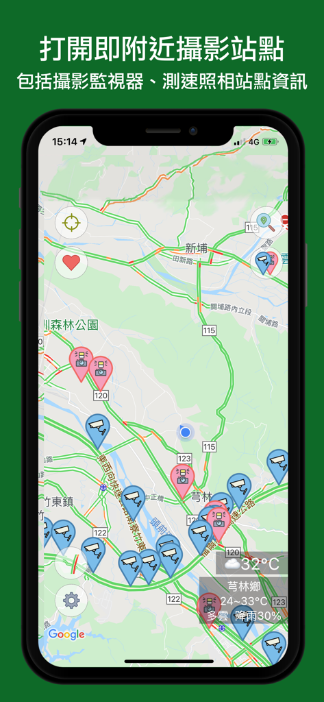
Smartphone screen displaying a map of Taiwan with real-time traffic CCTV and speed camera icons.
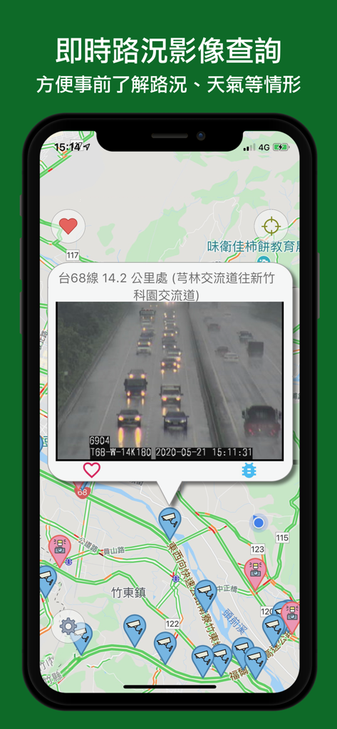
Smartphone screen displaying a real-time traffic camera feed on a map of Taiwan
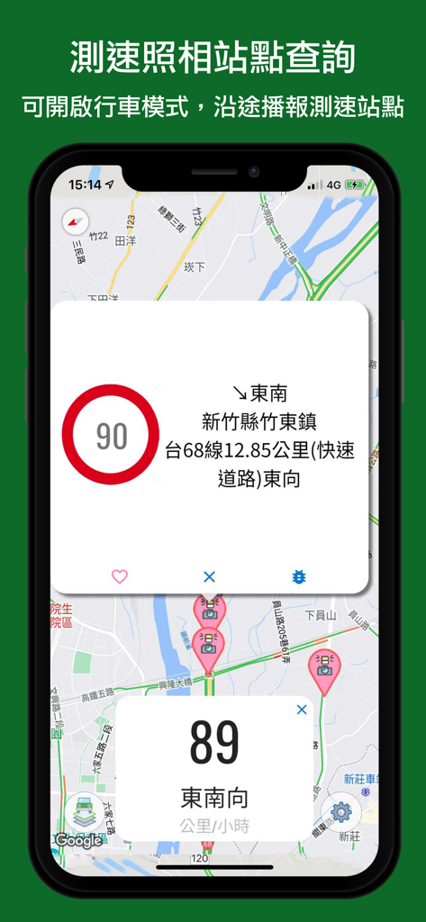
A mobile app interface showing a map of Taiwan with speed camera icons and a 90 kilometer per hour speed limit warning.
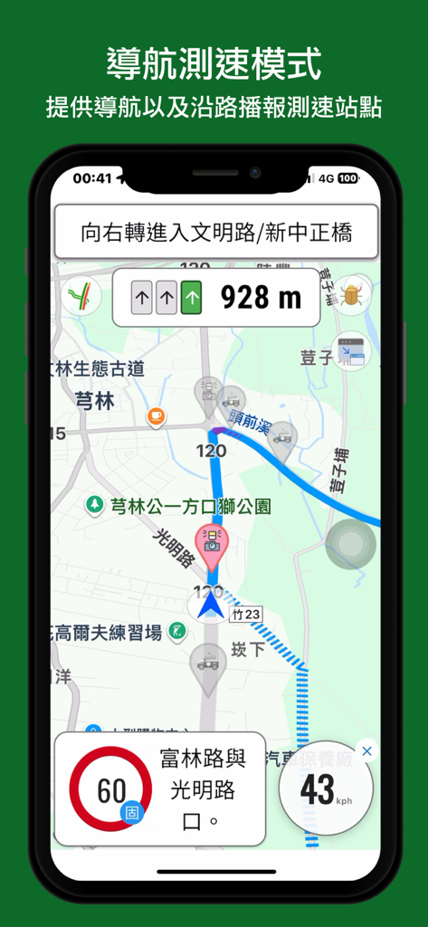
Mobile app interface showing a navigation map with real-time speed camera warnings and vehicle speed detection in Taiwan.
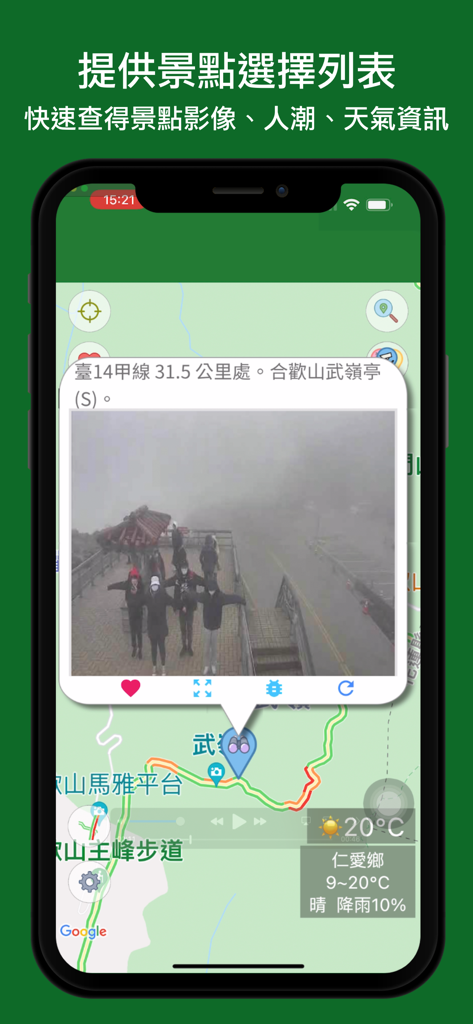
Mobile app screen showing a live CCTV feed of a Taiwan tourist attraction with local weather and map
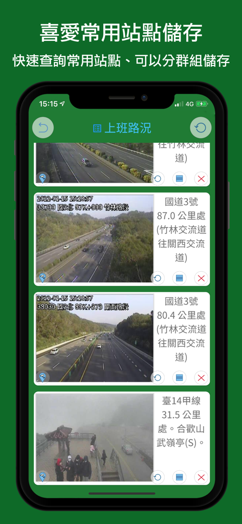
A list of favorite real-time traffic camera feeds showing highway conditions in Taiwan

Real-time traffic map of Taiwan with CCTV icons and road condition alerts
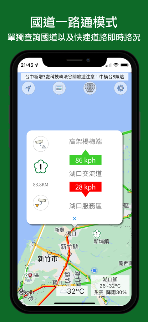
Taiwan traffic app interface showing highway speeds and map
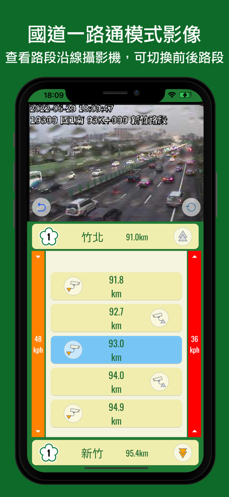
Real-time traffic camera feed and camera locations on a Taiwan highway navigation app
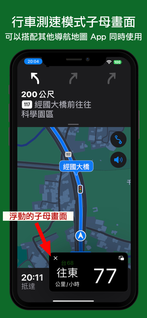
Navigation app screenshot demonstrating the picture-in-picture mode for speed alerts and traffic monitoring over a map interface.
설명
Download
비슷한 앱
유사한 기능과 사용자 경험을 가진 앱

Waze Navigation & Live Traffic
waze

LeisecaMaps
Alan Costa

MapXplorer: Map Radar Navigate
GOLDLAB APPLICATIONS YAZILIM VE BILISIM ANONIM SIRKETI

Radarbot: Speed Cameras | GPS
Iteration Mobile S.L

Yandex Navi – navigation, maps
DIRECT CURSUS COMPUTER SYSTEMS TRADING LLC

TomTom - Maps & Traffic
TomTom

ASFINAG
ASFINAG MAUT SERVICE GMBH

導航王 TM
KingwayTek Technology Co., Ltd.

Speed Cameras Radar
Bigdream Corporation
이 페이지는 앱이나 개발자의 공식 페이지가 아니며, 정보 제공 및 논평을 목적으로 작성된 독립 편집 간행물입니다. 명시적으로 달리 언급되지 않는 한, 해당 앱이나 개발자는 MWM, Apple, Google Play, 앱 퍼블리셔 또는 앱 개발자와 제휴, 보증, 후원, 승인 또는 공식적으로 연결되어 있지 않으며, 이 페이지의 어떤 내용도 해당 앱이 MWM의 서비스를 사용하여 개발되었음을 의미하지 않습니다. 모든 상표, 로고, 스크린샷 및 기타 콘텐츠는 해당 소유자의 자산입니다.