이 페이지는 앱이나 개발자의 공식 페이지가 아니며, 정보 제공 및 논평을 목적으로 작성된 독립 편집 간행물입니다. 명시적으로 달리 언급되지 않는 한, 해당 앱이나 개발자는 MWM, Apple, Google Play, 앱 퍼블리셔 또는 앱 개발자와 제휴, 보증, 후원, 승인 또는 공식적으로 연결되어 있지 않으며, 이 페이지의 어떤 내용도 해당 앱이 MWM의 서비스를 사용하여 개발되었음을 의미하지 않습니다. 모든 상표, 로고, 스크린샷 및 기타 콘텐츠는 해당 소유자의 자산입니다.

Desert Maps: Navigator Offline
이 앱은 당신이 문명에서 멀리 떨어져 있을 때도 길을 잃지 않는 절대적인 힘을 부여합니다. 지도 한 장 없던 시절의 무능함은 옛말이 됩니다.
다운로드
100k+사용자 평점
총 평가 수
3.2K개발사
카테고리
Navigation지원 언어
44최신 버전
8크기
147.9 MB출시일
2025년 2월 5일오프라인 환경 탐색을 위한 필수 기능 분석
Desert Maps: Navigator Offline 앱 주요 기능 평가
오프라인 및 통신망 독립 작동
이 앱은 인터넷 연결이나 모바일 네트워크 커버리지 없이 사막과 도시 모두에서 효율적으로 작동하여 어디서든 안정적인 내비게이션을 제공합니다.
상세 오프라인 지도
이 도구는 OpenStreetMap 커뮤니티의 기여를 바탕으로 다른 지도에서는 찾을 수 없는 위치를 포함한 상세한 오프라인 지도를 제공합니다.
경로 추적 및 기록
사용자는 여행 경로를 기록하여 동일한 경로를 통해 안전하게 돌아올 수 있으며, 이는 탐험 중 길을 잃을 위험을 줄여줍니다.
모든 좌표 유형 지원
이 앱은 모든 유형의 좌표를 입력하고 공유할 수 있도록 지원하여 쉬운 내비게이션 계획과 정밀한 위치 파악을 가능하게 합니다.
등고선 및 고도 프로필
이 도구는 봉우리, 경사 및 등고선에 대한 명확한 세부 정보를 제공하여 지형을 정확하게 이해하고 경로를 계획하는 데 도움을 줍니다.
데이터 가져오기 및 내보내기
사용자는 KML, KMZ, GPX와 같은 다양한 형식으로 랜드마크와 지도를 가져오고 내보낼 수 있어 다른 플랫폼과의 유연한 데이터 교환을 가능하게 합니다.
종합적인 경로 안내
이 앱은 도로, 직선 또는 나침반 기반 내비게이션을 통해 사용자의 선호에 따라 종합적인 경로 안내를 제공합니다.
위치 저장 및 검색
사용자는 중요한 위치를 저장하고 언제든지 쉽게 접근할 수 있어 관심 지점을 효율적으로 관리할 수 있습니다.
거리 측정 도구
이 도구는 위치 간 거리를 높은 정확도로 측정할 수 있는 통합 기능을 제공하여 계획 및 분석에 유용합니다.
기존 내비게이션 기기 대체
이 앱은 기존 내비게이션 기기를 대체하며, 부드럽고 통합된 내비게이션 경험을 제공합니다.
자주 묻는 질문
에 대해 알아야 할 모든 것 Desert Maps: Navigator Offline
Does Desert Maps: Navigator Offline work without an internet connection?
Yes, the Desert Maps app operates efficiently in both deserts and cities without requiring an internet connection or mobile network coverage.
Is Desert Maps: Navigator Offline a free app?
No, Desert Maps offers a 3-day free trial to explore its features. After the trial, users must subscribe to a paid package to access professional features.
What navigation modes does the Desert Maps app support?
The Desert Maps app supports comprehensive navigation via roadways, direct line, or compass-based navigation. It also offers car, bicycle, and walking routes.
Where does Desert Maps: Navigator Offline get its detailed offline maps from?
The Desert Maps app provides detailed offline maps for all countries, sourced from the OpenStreetMap community. This allows for locations not found on other maps.
Can I record my trip's path with Desert Maps: Navigator Offline?
Yes, the Desert Maps app features trip tracking. You can record your trip's path to safely and comfortably return via the same route, and it records GPX tracks.
What data formats can Desert Maps: Navigator Offline import and export?
The Desert Maps app supports importing and exporting landmarks and maps in various formats, including KML, KMZ, and GPX.
Does Desert Maps: Navigator Offline support different coordinate types?
Yes, the Desert Maps app supports the input and sharing of all types of coordinates. This feature facilitates easy navigation and planning.
What new features are coming soon to the Desert Maps app?
Soon, the Desert Maps app will add features such as weather updates, rain radar, spring detection radar, and satellite imagery. The developers are open to suggestions.
다음 스크린샷과 설명은 앱의 공식 스토어 목록에서 직접 가져온 것이며 앱 개발자의 자산입니다.
앱 스토어
스크린샷
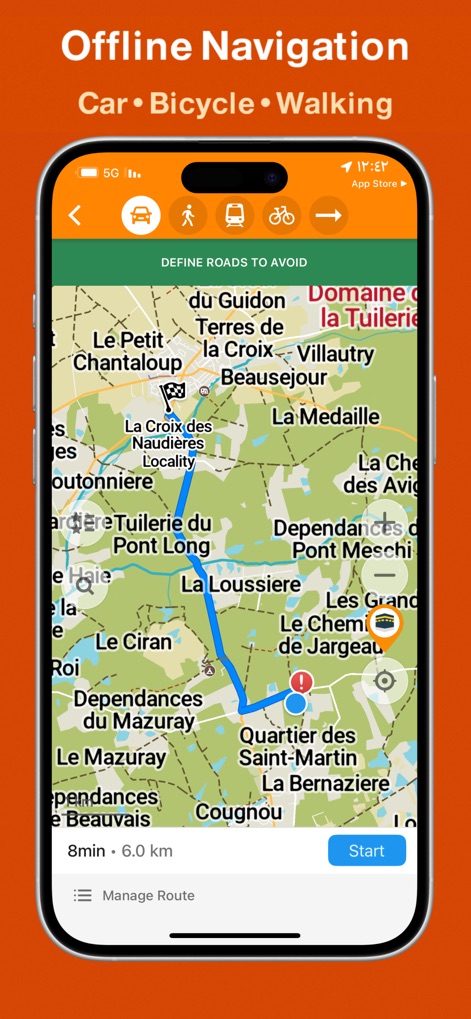
이 앱은 인터넷 연결 없이도 자동차, 자전거, 도보 등 다양한 이동 수단에 대한 경로를 계획할 수 있으며, 지도에 표시된 예상 소요 시간과 거리를 제공합니다.
오프라인 경로 탐색
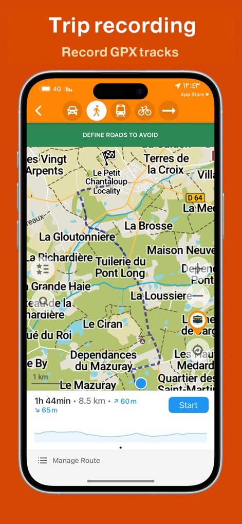
사용자는 이 도구를 사용하여 GPX 트랙으로 이동 경로를 기록하고, 총 거리 및 고도 변화를 포함한 상세한 여정 정보를 그래프로 시각적으로 확인할 수 있습니다.
여정 추적 및 분석
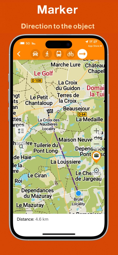
이 앱은 특정 지점에 마커를 설정하고 현재 위치에서 목표 지점까지의 직선 거리를 정확하게 측정하여 사용자가 원하는 위치로 쉽게 이동할 수 있도록 돕습니다.
목표 지점 탐색
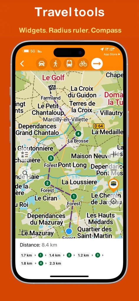
이 도구는 지도 위에서 여러 개의 번호 매겨진 지점을 설정하여 각 지점 간의 거리를 정확하게 측정하고, 사용자가 복잡한 경로를 효율적으로 계획하고 관리할 수 있도록 지원합니다.
다재다능한 여행 도구
설명
Download
비슷한 앱
유사한 기능과 사용자 경험을 가진 앱

Detecht - Motorcycle App & GPS
Detecht Technologies AB

REVER - Motorcycle GPS & Rides
Rever, LLC

NYSSA Snowmobile Trails
Mapgears Inc.

Scenic Motorcycle Navigation
Applified Life Ltd.

Trails Offroad: Offline Maps
TRAILS OFFROAD LLC

Overland Bound One: Maps & GPS
Overland Bound Inc

Stegra.io - Motorcycle GPS
Stegraio AB

GoSnowmobiling NB
Mapgears Inc.

Lost Riders
Lost Riders, LLC
이 페이지는 앱이나 개발자의 공식 페이지가 아니며, 정보 제공 및 논평을 목적으로 작성된 독립 편집 간행물입니다. 명시적으로 달리 언급되지 않는 한, 해당 앱이나 개발자는 MWM, Apple, Google Play, 앱 퍼블리셔 또는 앱 개발자와 제휴, 보증, 후원, 승인 또는 공식적으로 연결되어 있지 않으며, 이 페이지의 어떤 내용도 해당 앱이 MWM의 서비스를 사용하여 개발되었음을 의미하지 않습니다. 모든 상표, 로고, 스크린샷 및 기타 콘텐츠는 해당 소유자의 자산입니다.