이 페이지는 앱이나 개발자의 공식 페이지가 아니며, 정보 제공 및 논평을 목적으로 작성된 독립 편집 간행물입니다. 명시적으로 달리 언급되지 않는 한, 해당 앱이나 개발자는 MWM, Apple, Google Play, 앱 퍼블리셔 또는 앱 개발자와 제휴, 보증, 후원, 승인 또는 공식적으로 연결되어 있지 않으며, 이 페이지의 어떤 내용도 해당 앱이 MWM의 서비스를 사용하여 개발되었음을 의미하지 않습니다. 모든 상표, 로고, 스크린샷 및 기타 콘텐츠는 해당 소유자의 자산입니다.

Earthquake - alerts and map
USGS, EMSC 및 NOAA의 가장 빠른 전 세계 경고를 신뢰하는 5백만 명의 사용자와 함께하세요. iPhone 및 Apple Watch에서 광고 없는 고정밀 지도 및 중요 알림으로 정보를 얻으세요.
다운로드
3M+사용자 평점
총 평가 수
175K+개발사
카테고리
Weather지원 언어
17최신 버전
7.3.1크기
45.1 MB출시일
2013년 5월 9일완벽한 안전을 위한 전문 모니터링
5백만 명 이상의 사용자에게 신뢰받는 저희 앱은 가장 중요한 것을 보호하는 데 도움이 되는 실시간 지진 데이터와 중요 경고를 제공합니다.
즉각적인 중요 경고
'방해 금지 모드'를 우회할 수 있는 우선순위 높은 알림을 받아 이벤트 감지 순간 생명을 구하는 정보를 얻을 수 있습니다.
USGS, EMSC 및 NOAA의 라이브 피드에 접근하고 지각판, 화산 위치 및 인구 밀도를 보여주는 고급 지도 레이어를 이용하세요.
자주 묻는 질문
에 대해 알아야 할 모든 것 Earthquake - alerts and map
What is the "Earthquake - alerts and map" app?
"Earthquake - alerts and map" 앱은 iPhone 및 iPad용 최고의 지진 애플리케이션으로, 전 세계 지진 데이터, 푸시 알림, 이벤트 정보가 포함된 상세 지도를 제공합니다.
Does the "Earthquake - alerts and map" app offer push notifications for earthquakes?
네, "Earthquake - alerts and map" 앱은 공식 소스의 데이터를 사용할 수 있는 즉시 지진 이벤트에 대한 풍부한 푸시 알림을 제공합니다. 사용자는 최대 4개의 알림을 설정할 수 있습니다.
Can users filter earthquake notifications in the "Earthquake - alerts and map" app?
네, 사용자는 "Earthquake - alerts and map" 앱에서 규모 임계값 및 위치별로 알림을 필터링할 수 있습니다. 사용자 지정 필터를 통해 최소 규모 및 특정 반경을 알림용으로 설정할 수 있습니다.
What data sources does the "Earthquake - alerts and map" app use?
"Earthquake - alerts and map" 앱은 USGS, EMSC, GeoScience Australia, GNS Science, Instituto Geográfico Nacional, Servicio Sismológico Nacional, British Geological Survey, GFZ GEOFON, Natural Resources Canada, NOAA를 포함한 여러 공식 소스를 사용합니다.
How can users search the earthquake catalog in the "Earthquake - alerts and map" app?
사용자는 "Earthquake - alerts and map" 카탈로그를 날짜, 장소, 국가/주/대륙, 데이터 소스 또는 지도에 표시된 특정 지역별로 검색할 수 있습니다. 카탈로그는 1970년까지 거슬러 올라갑니다.
What map layers are available in the "Earthquake - alerts and map" app?
"Earthquake - alerts and map" 앱은 지각판 경계, 조산대, 화산, 원자력 발전소, 인구 밀도에 대한 지도 레이어를 제공합니다. 이는 시각적 데이터 표현을 향상시킵니다.
Does the "Earthquake - alerts and map" app provide tsunami information?
네, "Earthquake - alerts and map" 앱은 NOAA의 데이터를 활용하여 쓰나미 경보 및 상세 정보를 제공하여 사용자가 잠재적 쓰나미 이벤트에 대한 정보를 얻을 수 있도록 합니다.
Does the "Earthquake - alerts and map" app contain advertisements?
아니요, "Earthquake - alerts and map" 앱에는 광고가 포함되어 있지 않아 지진 데이터 및 알림에 대한 중단 없는 사용자 경험을 보장합니다.
Does "Earthquake - alerts and map" support Critical Alerts?
네, "Earthquake - alerts and map" 앱은 중요한 알림을 지원합니다. 이러한 알림은 무음 모드 및 방해 금지 설정을 우회하여 중요한 지진 알림이 항상 들리도록 합니다.
Does the "Earthquake - alerts and map" app include user-reported earthquake data?
네, "Earthquake - alerts and map" 앱은 사용자 보고를 기반으로 한 알림을 지원합니다. 또한 지도에 지진 데이터로 확인된 앱 사용자들의 예비 보고서를 표시합니다.
다음 스크린샷과 설명은 앱의 공식 스토어 목록에서 직접 가져온 것이며 앱 개발자의 자산입니다.
앱 스토어
스크린샷
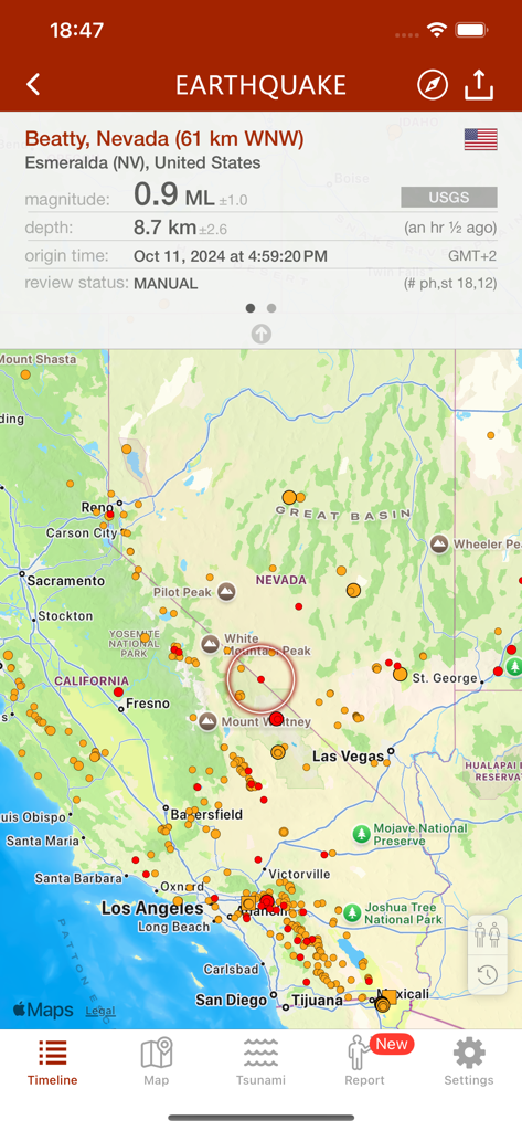
캘리포니아와 네바다의 지진 활동 및 이벤트 데이터를 보여주는 지진 앱 지도.
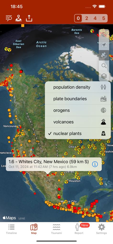
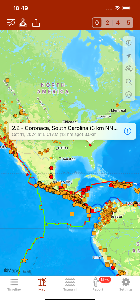
북미 전역의 지진 활동 및 원자력 발전소 위치를 보여주는 지진 앱 지도 보기.
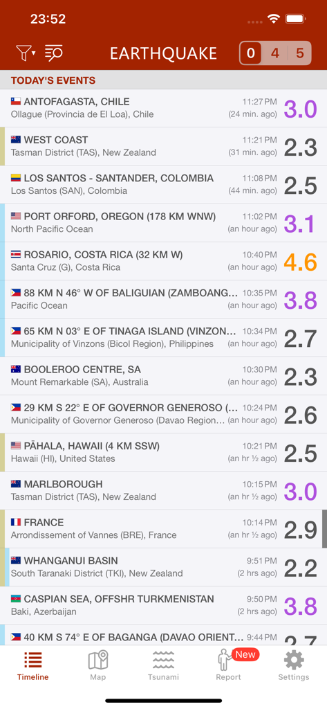
지진 앱에서 규모와 위치별 최근 전 세계 지진 이벤트 목록을 보여주는 스마트폰 화면.
지진 앱에서 지진 활동 경고 및 지각판 경계를 표시하는 세계 지도.
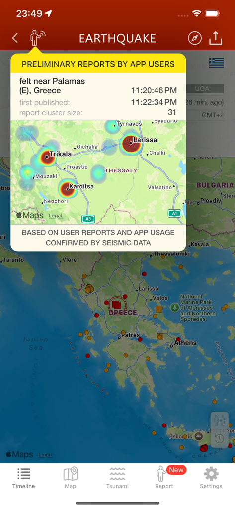
그리스의 지진 활동에 대한 사용자 보고서 및 히트맵을 표시하는 지진 앱 인터페이스
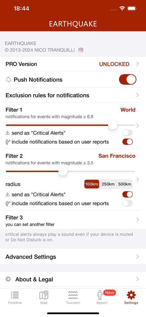
샌프란시스코와 같은 지진 및 위치에 대한 지진 알림 필터링을 보여주는 설정 화면
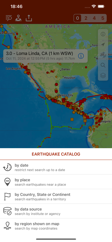
날짜 및 위치 필터가 있는 아메리카 대륙의 지진 활동 지도 및 지진 카탈로그 검색 옵션
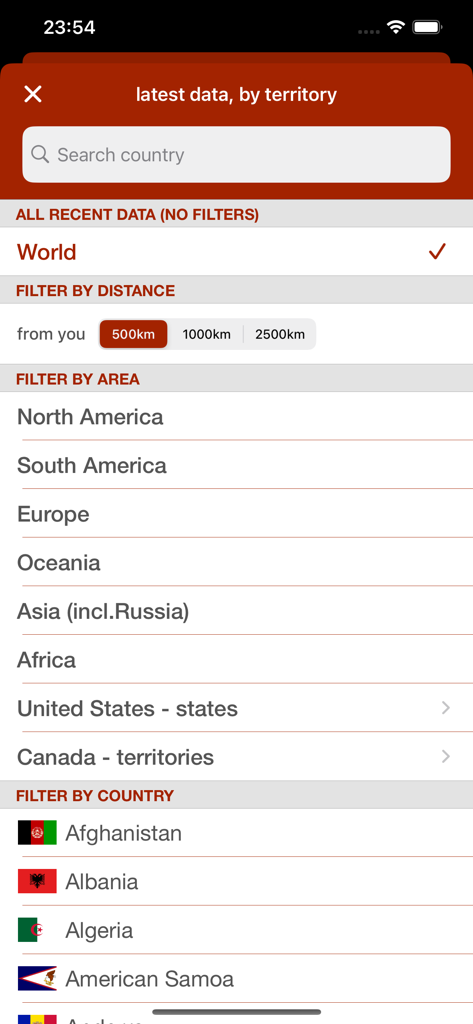
국가 및 지역별 지진 이벤트 필터링을 위한 지진 앱 인터페이스
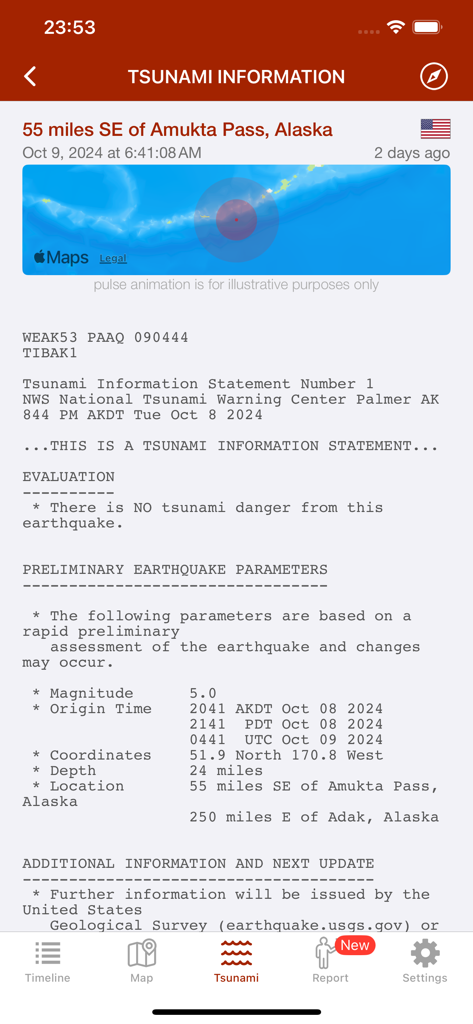
알래스카 근처 규모 5.0 이벤트와 쓰나미 위험 없음 상태를 보여주는 지진 앱의 쓰나미 정보 화면.
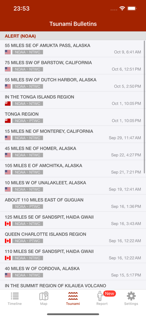
지진 앱에 표시된 NOAA의 쓰나미 경고 및 게시물 목록
설명
Download
비슷한 앱
유사한 기능과 사용자 경험을 가진 앱

Alerta Sísmica México - SASSLA
Diego Ramirez

QuakeFeed Earthquake Alerts
Artisan Global LLC

My Earthquake Alerts Pro
JRustonApps B.V.

My Earthquake Alerts & Feed
JRustonApps B.V.

Earthquake+ Alerts, Map & Info
Slava Barouline

LastQuake
Ctre Sismologique Euro Mediterraneen

Earthquake Alert - Seismic
婷 张

Volcanoes: Map, Alerts & Ash
Slava Barouline

EarthQuake+
Avni Sagiroglu
이 페이지는 앱이나 개발자의 공식 페이지가 아니며, 정보 제공 및 논평을 목적으로 작성된 독립 편집 간행물입니다. 명시적으로 달리 언급되지 않는 한, 해당 앱이나 개발자는 MWM, Apple, Google Play, 앱 퍼블리셔 또는 앱 개발자와 제휴, 보증, 후원, 승인 또는 공식적으로 연결되어 있지 않으며, 이 페이지의 어떤 내용도 해당 앱이 MWM의 서비스를 사용하여 개발되었음을 의미하지 않습니다. 모든 상표, 로고, 스크린샷 및 기타 콘텐츠는 해당 소유자의 자산입니다.