이 페이지는 앱이나 개발자의 공식 페이지가 아니며, 정보 제공 및 논평을 목적으로 작성된 독립 편집 간행물입니다. 명시적으로 달리 언급되지 않는 한, 해당 앱이나 개발자는 MWM, Apple, Google Play, 앱 퍼블리셔 또는 앱 개발자와 제휴, 보증, 후원, 승인 또는 공식적으로 연결되어 있지 않으며, 이 페이지의 어떤 내용도 해당 앱이 MWM의 서비스를 사용하여 개발되었음을 의미하지 않습니다. 모든 상표, 로고, 스크린샷 및 기타 콘텐츠는 해당 소유자의 자산입니다.
eVario2 - Variometer Pro
9축 센서 정밀도, 고급 날씨 에마그램, 3D 비행 기록으로 열기류를 정복하세요. 외부 하드웨어 없이 켜고 바로 비행하세요.
주요 수치
다운로드
26K+
사용자 평점
1.0/5
총 평가 수
0
개발사
Jean-Marc Meyer
카테고리
Sports
지원 언어
3
최신 버전
3.8
크기
98.5 MB
출시일
2022년 2월 23일
기능
전문가 등급의 정밀도로 비행을 향상시키세요
실시간 센서 정확도와 고급 데이터 분석을 요구하는 조종사를 위해 설계된 고성능 비행 컴퓨터로 iPhone을 바꿔보세요.
정밀 계기판
외부 하드웨어 없이도 초정밀 수직 속도계, 고도계, 지면 속도 데이터를 활용하세요.
스마트 열기류 감지
열기류를 더 효율적으로 식별, 중앙 집중화 및 활용하는 데 도움이 되도록 설계된 실시간 음향 및 시각 피드백을 사용하여 공중을 정복하세요.
다음 스크린샷과 설명은 앱의 공식 스토어 목록에서 직접 가져온 것이며 앱 개발자의 자산입니다.
앱 스토어
스크린샷
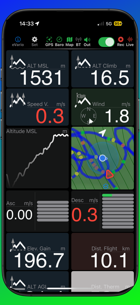
eVario2 앱 대시보드가 고도, 속도 및 바람 측정값을 포함한 패러글라이딩 실시간 비행 데이터를 표시하고 있습니다
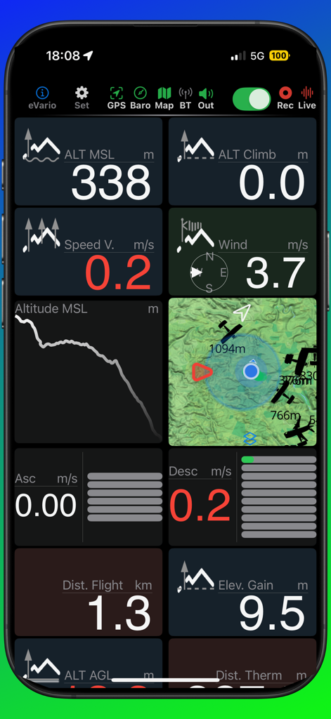
eVario2 비행 조종석 대시보드가 실시간 고도, 풍속 및 지형 지도 데이터를 표시하고 있습니다
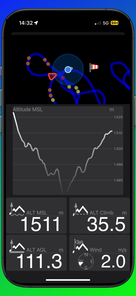
eVario2 비행 조종석이 고도 그래프와 실시간 비행 측정값을 표시하고 있습니다
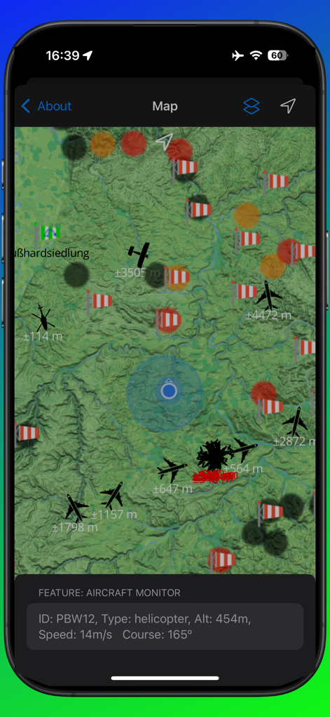
eVario2의 지형 지도 보기에서 실시간 항공기 추적 및 비행 데이터를 표시하고 있습니다
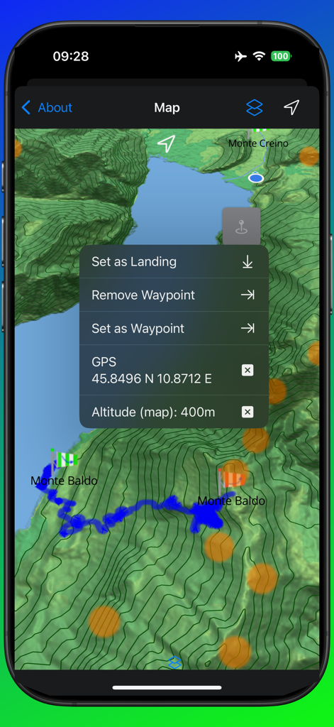
eVario2 앱에서 웨이포인트 선택 메뉴가 있는 지형 비행 지도
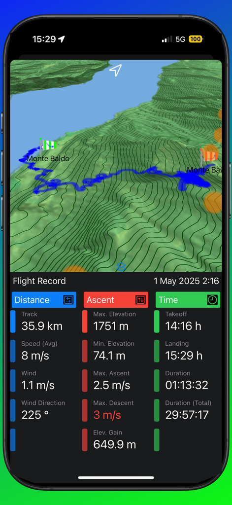
eVario2 앱이 지형 지도에 3D 비행 경로를 표시하고 있으며 거리, 속도, 상승 및 비행 시간에 대한 자세한 측정값이 있습니다
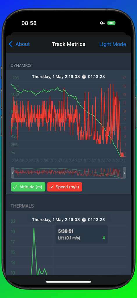
eVario2 앱 인터페이스가 에어로 스포츠 애호가를 위한 고도 및 속도 역학 그래프를 포함한 자세한 비행 경로 측정값을 표시하고 있습니다
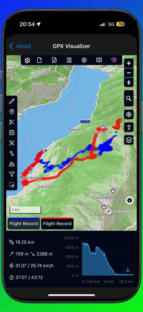
eVario2 앱 스크린샷이 산악 지도 위의 패러글라이딩 비행 경로와 속도 및 고도와 같은 성능 통계를 보여주는 GPX 시각화 도구를 표시하고 있습니다
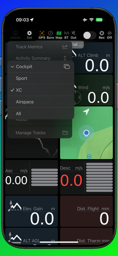
eVario2 비행 계기판이 XC 모드 메뉴 옵션을 표시하고 있습니다
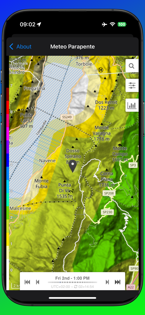
eVario2 앱에서 패러글라이딩을 위한 열기류 핫스팟과 속도를 보여주는 지형 날씨 지도
설명
App with new design!
--
eVario is your connected flight navigation companion during and after your adventure trip to visualise relevant data, assist you while progressing in the air by returning visual and acoustical feedback.
eVario is a 9-axis measurement (accelerometer, gyrometer, gps), barometer assisted, connected and intuitive instrument with a polychrom display, exploiting the embedded device’s hardware and accurate sensoric, without need to connect external devices. It typically provides real time information of a variometer like altimeter, speedometer, odometer, chronometer, gyrometer, anemometer for every (air)craft pilot. Its configurable cockpit allows you to keep track of the most relevant to you. The integrated data logger automatically records your 3D location and provides the recorded track file to your iCloud for track visualisation or flight metrics.
Turn on & Fly!
No need for additional/external hardware.
eVario is mainly designed for paragliding/hang-gliding, but may be used as well while biking, hiking, running, sailing, skiing, flying, …
Optimised for low battery usage, the app lets you:
▶ PLAN AHEAD: Check detailed weather conditions (emagram) over days for your safety, in Europe. Check surroundings and thermal hotspots on the topographic outdoor map.
▶ PLAN LANDING: Set a marker e.g. at the landing area and get assistance when approaching.
▶ TOUCH&GO: Turn on & Go fly! The cockpit shows real-time data after a short automatic instrument calibration.
▶ TAKE OFF: Automatic track recording is taking place in background and take-off altitude is referenced.
▶ STAY IN CONTROL: Control the behaviour, update rate, unit of the instruments, anytime and anywhere. Select a pre-defined setting profile matching thermal conditions.
▶ THERMALLING: Get acoustical and visual feedback of the encountered thermals and easily locate them when returning back.
▶ BE EFFICIENT: Track wind estimation, direction and force, to soar or prepare your landing.
▶ FIND LANDING: At e.g. a new site, locate the marked landing zone.
▶ REVIEW TRACK: Visualise the past track on 4 map styles or show the track elevation profile graph in animated or interactive mode.
▶ MANAGE LOGBOOK: Access each individual track record time stamped file, synchronise them with your iCloud. Personalise eVario to contain glider/user information.
▶ DO MORE: Re-Play your 3D flight e.g. in GoogleEarth, Analyse flight metrics in BaseCamp.
KEY FEATURES
*Cockpit
▶ Clear dashboard of digital real time data
▶ Advanced interactive cockpit with configurable measurement field display
▶ Access a large number of settings directly impacting sensoric, display, acoustic or interaction
▶ Unlimited GPS tracks and waypoints saves
▶ Support of metric and imperial unit system
▶ Support of GPX/IGC record formats
▶ Automatic tracking start/stop upon movement detection
▶ Automatic GPS track recording
▶ Logbook with individual 3D GPS track records (timestamp, latitude, longitude, elevation) supporting derived data analysis
▶ Manage/Share track files from within integrated file browser
*Map
▶ Visualise your position, track line, thermal hotspots, sites, weather data on map
▶ Map enhancement by overlaid instruments like altitude, speed or ascent
▶ Map style selection: choose from 4 styles including terrain (dark/bright), topo and satellite
▶ Offline map downloads worldwide! Including topographic data, peak names and heights
▶ Unlimited map downloading for offline use (saves mobile data)
▶ Waypoint setting
*Assistance
▶ Advanced interactive assistance with voice coaching
▶ Pre-defined setting profiles for weak, normal and strong thermals
▶ Connected variometer (map, detailed/layered meteorological weather data, SOS)
*Graph
▶ Bar graph for vertical ascent/descent with peak hold functionality
▶ Visualise current and last track elevation profile versus time
▶ Visualise altitude on graph
*Supported Languages
▶ English, French, German, Spanish, Russian
More on the developer's website.
이 페이지는 앱이나 개발자의 공식 페이지가 아니며, 정보 제공 및 논평을 목적으로 작성된 독립 편집 간행물입니다. 명시적으로 달리 언급되지 않는 한, 해당 앱이나 개발자는 MWM, Apple, Google Play, 앱 퍼블리셔 또는 앱 개발자와 제휴, 보증, 후원, 승인 또는 공식적으로 연결되어 있지 않으며, 이 페이지의 어떤 내용도 해당 앱이 MWM의 서비스를 사용하여 개발되었음을 의미하지 않습니다. 모든 상표, 로고, 스크린샷 및 기타 콘텐츠는 해당 소유자의 자산입니다.