이 페이지는 앱이나 개발자의 공식 페이지가 아니며, 정보 제공 및 논평을 목적으로 작성된 독립 편집 간행물입니다. 명시적으로 달리 언급되지 않는 한, 해당 앱이나 개발자는 MWM, Apple, Google Play, 앱 퍼블리셔 또는 앱 개발자와 제휴, 보증, 후원, 승인 또는 공식적으로 연결되어 있지 않으며, 이 페이지의 어떤 내용도 해당 앱이 MWM의 서비스를 사용하여 개발되었음을 의미하지 않습니다. 모든 상표, 로고, 스크린샷 및 기타 콘텐츠는 해당 소유자의 자산입니다.

Explore Hong Kong
현지인처럼 자신 있게 MTR을 탐색하세요. CNN과 Lonely Planet이 신뢰하는 저희의 사용하기 쉬운 경로 플래너와 거리 지도는 인터넷 연결 없이 100% 오프라인으로 작동합니다—데이터 또는 로밍이 필요하지 않습니다.
다운로드
127K+사용자 평점
총 평가 수
1K+개발사
카테고리
Travel지원 언어
5최신 버전
20.0.0크기
29.9 MB출시일
2010년 1월 27일자신 있게 홍콩 MTR 마스터하기
CNN과 Lonely Planet이 신뢰하는 저희 앱은 스마트한 국제 여행자를 위해 특별히 설계된 가장 직관적인 오프라인 지원 교통 도구를 제공합니다.
100% 오프라인 자유
비싼 로밍 요금은 잊으세요. 지하 깊은 곳에서도 인터넷 연결 없이 전체 지도에 액세스하고, 역을 검색하고, 전체 경로를 계획하세요.
3번의 탭으로 경로 계획
더 빨리 목적지에 도착하세요. 간단한 세 번의 탭만으로 가장 빠른 경로를 계산하고 모든 여정에 대한 정확한 이동 시간을 얻으세요.
다음 스크린샷과 설명은 앱의 공식 스토어 목록에서 직접 가져온 것이며 앱 개발자의 자산입니다.
앱 스토어
스크린샷
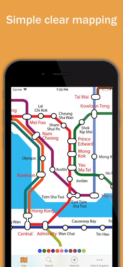
아이폰 화면에 표시된 홍콩의 간단하고 명확한 MTR 지하철 노선도
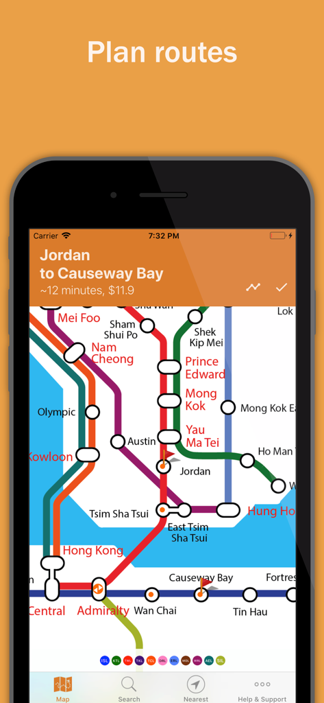
Explore Hong Kong 앱 경로 플래너, Jordan에서 Causeway Bay까지의 지하철 여정 표시
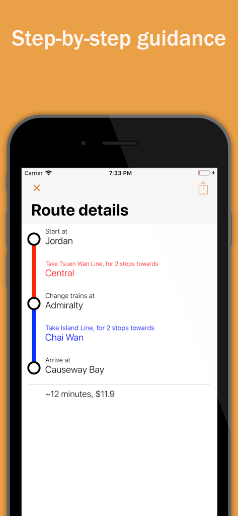
홍콩의 MTR 길 안내 및 이동 시간을 보여주는 단계별 경로 안내
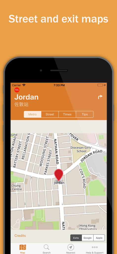
홍콩 Jordan MTR 역의 이중 언어 거리 및 출구 지도
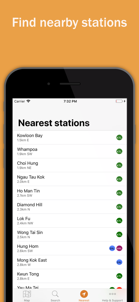
Explore Hong Kong 앱에서 거리와 노선 이름이 표시된 가장 가까운 홍콩 MTR 역 목록.
설명
Download
비슷한 앱
같은 카테고리의 상위 앱

Uber - Request a ride
Uber Technologies, Inc.

Airbnb
Airbnb, Inc.

铁路12306
ACADEMY OF RAILWAY SCIENCES CO., ltd.

Booking.com: Hotels & Travel
Booking.com B.V.

Grab: Taxi Ride, Food Delivery
GRABTAXI HOLDINGS PTE. LTD.

Trip.com: Book Flights, Hotels
Trip.com Travel Singapore Pte. Ltd.

DiDi China: Ride Hailing
Didi Chuxing (Beijing) Network Platform Technology Co., Ltd

去哪儿旅行-订酒店机票火车票
Beijing Qunar Information Technology Company Limit

Bolt: Request a Ride
BOLT TECHNOLOGY OU
이 페이지는 앱이나 개발자의 공식 페이지가 아니며, 정보 제공 및 논평을 목적으로 작성된 독립 편집 간행물입니다. 명시적으로 달리 언급되지 않는 한, 해당 앱이나 개발자는 MWM, Apple, Google Play, 앱 퍼블리셔 또는 앱 개발자와 제휴, 보증, 후원, 승인 또는 공식적으로 연결되어 있지 않으며, 이 페이지의 어떤 내용도 해당 앱이 MWM의 서비스를 사용하여 개발되었음을 의미하지 않습니다. 모든 상표, 로고, 스크린샷 및 기타 콘텐츠는 해당 소유자의 자산입니다.