이 페이지는 앱이나 개발자의 공식 페이지가 아니며, 정보 제공 및 논평을 목적으로 작성된 독립 편집 간행물입니다. 명시적으로 달리 언급되지 않는 한, 해당 앱이나 개발자는 MWM, Apple, Google Play, 앱 퍼블리셔 또는 앱 개발자와 제휴, 보증, 후원, 승인 또는 공식적으로 연결되어 있지 않으며, 이 페이지의 어떤 내용도 해당 앱이 MWM의 서비스를 사용하여 개발되었음을 의미하지 않습니다. 모든 상표, 로고, 스크린샷 및 기타 콘텐츠는 해당 소유자의 자산입니다.

다운로드
220K+사용자 평점
총 평가 수
200개발사
카테고리
Navigation지원 언어
1최신 버전
2025.31크기
23.7 MB출시일
2010년 6월 21일모든 비행 단계에 대한 전문적인 정확성
숙련된 항공기 조종사들이 제작한 FlyBy E6B는 비행 학교 시험부터 복잡한 상업 운영까지 수동 계산을 없애고 인지 부하를 줄이도록 설계된 70가지 이상의 전문 항공 도구를 제공합니다.
고급 항법 및 VNAV
Critical Point, Point of No Return, 정밀 수직 항법(VNAV) 하강 프로필을 위한 전문 등급 도구로 기본 수학을 넘어서세요.
실시간 바람 및 속도
정확한 항공 속도(TAS), 지상 속도 및 맞바람/측풍 구성 요소에 대한 즉각적인 계산으로 항공기보다 앞서 나가십시오.
다음 스크린샷과 설명은 앱의 공식 스토어 목록에서 직접 가져온 것이며 앱 개발자의 자산입니다.
앱 스토어
스크린샷
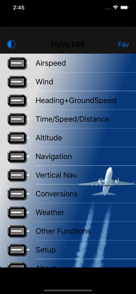
FlyBy E6B 메인 메뉴 인터페이스에 항공 계산 옵션 표시
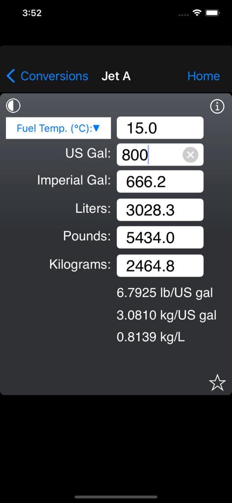
FlyBy E6B 앱 인터페이스에 Jet A 연료 부피 및 무게 변환 화면 표시

FlyBy E6B 앱에서 비행 계획을 위한 항공 승객 무게 계산 화면
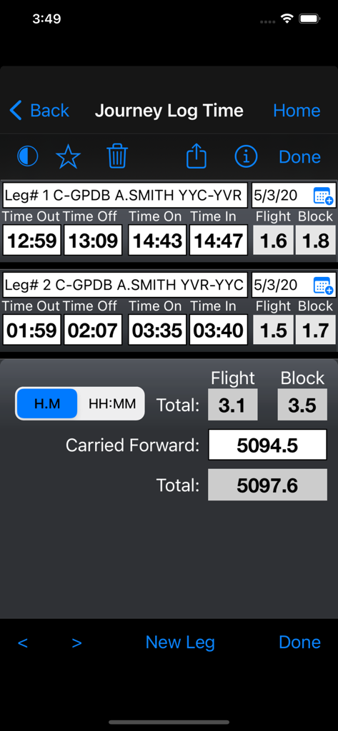
FlyBy E6B 앱 인터페이스에 여러 구간의 비행 및 블록 시간 계산이 포함된 여정 기록 시간 기능 표시
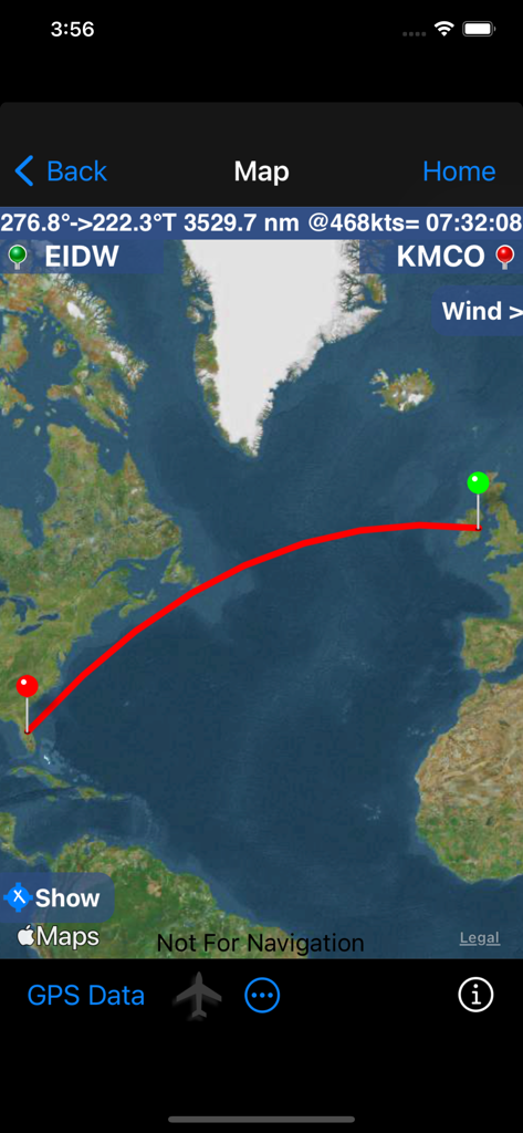
FlyBy E6B 앱 지도 인터페이스에 더블린에서 올랜도까지의 거리 및 시간 세부 정보가 포함된 비행 경로 표시
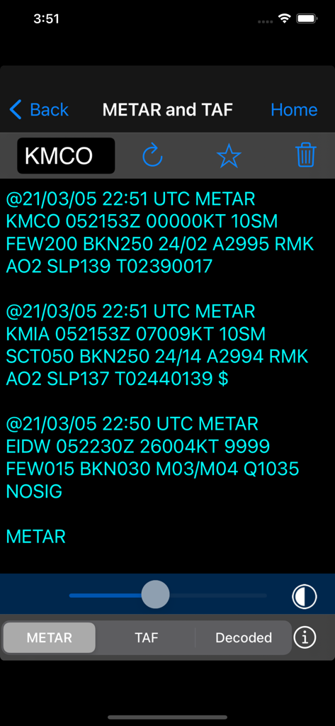
FlyBy E6B 앱에서 METAR 및 TAF 데이터를 보여주는 항공 날씨 보고서 화면
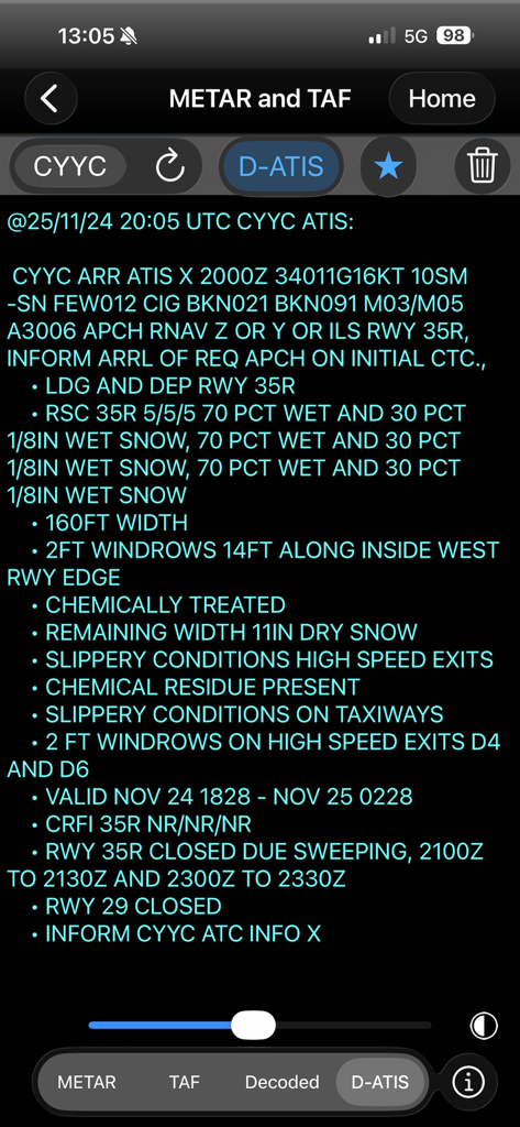
FlyBy E6B 앱에 상세 D-ATIS 날씨 보고서 및 활주로 조건 표시
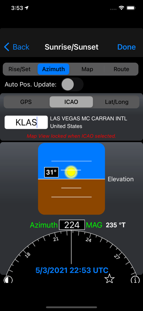
FlyBy E6B 앱에서 라스베이거스 공항의 일출 및 일몰 방위각 계산
설명
Download
비슷한 앱
유사한 기능과 사용자 경험을 가진 앱

BA Financial Calculator
Angel Montana

Astrology Master
ibrahim veli

Sporty's E6B Flight Computer
Sporty's Pilot Shop

BA Financial Calculator (PRO)
Angel Montana

Construction Master Pro Calc
Calculated Industries, Inc.

Construction Master 5 Calc
Calculated Industries, Inc.

Pipe Trades Pro Calc
Calculated Industries, Inc.

Qualifier Plus IIIx/fx
Calculated Industries, Inc.

Resolutioner
Sun Apps, LLC
이 페이지는 앱이나 개발자의 공식 페이지가 아니며, 정보 제공 및 논평을 목적으로 작성된 독립 편집 간행물입니다. 명시적으로 달리 언급되지 않는 한, 해당 앱이나 개발자는 MWM, Apple, Google Play, 앱 퍼블리셔 또는 앱 개발자와 제휴, 보증, 후원, 승인 또는 공식적으로 연결되어 있지 않으며, 이 페이지의 어떤 내용도 해당 앱이 MWM의 서비스를 사용하여 개발되었음을 의미하지 않습니다. 모든 상표, 로고, 스크린샷 및 기타 콘텐츠는 해당 소유자의 자산입니다.