이 페이지는 앱이나 개발자의 공식 페이지가 아니며, 정보 제공 및 논평을 목적으로 작성된 독립 편집 간행물입니다. 명시적으로 달리 언급되지 않는 한, 해당 앱이나 개발자는 MWM, Apple, Google Play, 앱 퍼블리셔 또는 앱 개발자와 제휴, 보증, 후원, 승인 또는 공식적으로 연결되어 있지 않으며, 이 페이지의 어떤 내용도 해당 앱이 MWM의 서비스를 사용하여 개발되었음을 의미하지 않습니다. 모든 상표, 로고, 스크린샷 및 기타 콘텐츠는 해당 소유자의 자산입니다.

Hiking Maps - PeakVisor
탐험가를 위한 최고의 비주얼 툴킷입니다. 백만 개 이상의 봉우리를 식별하고, 최첨단 3D 지형 모델링으로 내비게이션하며, 전문가급 GPS로 하이킹 또는 스키 모험을 추적하세요. 모든 기능은 오프라인에서도 사용 가능합니다.
다운로드
2M+사용자 평점
총 평가 수
62K+개발사
카테고리
Travel지원 언어
14최신 버전
5.73크기
150.6 MB출시일
2016년 12월 21일최첨단 도구로 모든 정상에 도전하세요
PeakVisor는 스마트폰을 고정밀 내비게이션 시스템으로 변환하여, 증강 현실(AR)과 3D 지형 모델링을 결합해 모든 산악 모험을 향상시킵니다.
즉각적인 봉우리 식별
카메라를 비추어 백만 개 이상의 봉우리를 즉시 식별하세요. 통신이 되지 않는 곳에서도 이름, 고도 및 상세 지형 데이터를 확인할 수 있습니다.
고정밀 3D 지도
차세대 지형도를 사용하여 자신 있게 길을 찾으세요. 몰입감 넘치는 3D 환경에서 산책로의 경사도와 지형의 미세한 차이를 시각화합니다.
자주 묻는 질문
에 대해 알아야 할 모든 것 Hiking Maps - PeakVisor
PeakVisor란 무엇인가요?
PeakVisor는 최첨단 봉우리 식별, 3D 지도, 트레일 및 야외 GPS 추적 기능을 제공하는 산악 내비게이션 앱입니다. 하이킹, 스키, 등반과 같은 활동을 위해 설계되었으며 상세한 3D 산악 경험을 제공합니다.
PeakVisor는 봉우리 식별을 위해 증강 현실을 사용하나요?
네, PeakVisor는 증강 현실(AR) 기술을 사용합니다. 실시간 식별을 위해 주변 봉우리의 이름과 고도를 iPhone 카메라 뷰에 직접 오버레이합니다.
PeakVisor는 몇 개의 산을 식별할 수 있나요?
PeakVisor는 전 세계적으로 백만 개 이상의 산, 언덕, 뷰트, 첨탑을 식별할 수 있습니다. 고도, 지형 돌출 정도, 산맥, 추가 Wikipedia 기사를 포함한 상세한 프로필을 제공합니다.
PeakVisor를 사용하여 하이킹 경로를 계획할 수 있나요?
네, PeakVisor는 3D 지도와 방대한 트레일 네트워크를 사용하여 하이킹 경로를 계획할 수 있습니다. 예상 거리, 고도 프로필, 예상 완료 시간을 평가하는 데 도움이 됩니다.
PeakVisor는 어떤 스키 기능을 제공하나요?
PeakVisor는 스키를 위한 지형 3D 지도를 제공하며, 산악 리프트, 스키 리조트 트레일, 백컨트리 경로를 상세하게 보여줍니다. 또한 겨울 모드와 눈사태 지형 식별을 위한 경사도 오버레이도 포함되어 있습니다.
PeakVisor는 케이블카 및 산장 정보를 표시하나요?
네, PeakVisor의 3D 지도에는 케이블카와 산장이 포함되어 있으며, 운행 시간표도 제공됩니다. 이 기능은 특히 유럽 지역에서 산악 목표물 계획에 도움이 됩니다.
PeakVisor는 제 야외 활동을 추적할 수 있나요?
네, PeakVisor는 하이킹, 스키, 산악 자전거와 같은 야외 모험을 위한 GPS 추적 기능을 제공합니다. 3D로 경로를 시각화하고, 거리 및 고도 상승과 같은 통계를 확인하며, GPX 파일을 내보낼 수 있습니다.
PeakVisor는 인터넷 연결 없이도 작동하나요?
네, PeakVisor의 모든 기능은 오프라인으로 작동합니다. 사용자는 알프스와 같은 지역의 지형 지도 데이터를 다운로드하여 인터넷 연결 없이도 모든 기능을 사용할 수 있습니다.
PeakVisor의 모든 기능을 제한 없이 어떻게 사용할 수 있나요?
사용자는 PeakVisor PRO를 구독하면 PeakVisor의 모든 기능을 제한 없이 사용할 수 있습니다. 이 프리미엄 구독은 월간 또는 연간 단위로 제공됩니다.
PeakVisor 앱에 광고가 표시되나요?
아니요, PeakVisor 앱에는 광고가 표시되지 않습니다. 앱에서 발생하는 모든 수익은 PeakVisor PRO의 사용자 구독에서 나옵니다.
PeakVisor를 사용하여 사진에 산을 태그할 수 있나요?
네, PeakVisor는 AR 기술을 사용하여 사진에 산을 태그할 수 있습니다. 봉우리 이름과 고도를 이미지에 오버레이하고 저장할 수 있습니다.
PeakVisor는 경로의 애니메이션 플라이오버 동영상을 제공하나요?
네, PeakVisor는 "애니메이션 플라이오버 동영상" 기능을 제공합니다. 사용자는 경로의 멋진 애니메이션을 시작하여 다른 사람과 공유하거나 추억을 다시 볼 수 있습니다.
다음 스크린샷과 설명은 앱의 공식 스토어 목록에서 직접 가져온 것이며 앱 개발자의 자산입니다.
앱 스토어
스크린샷
산이 부르고 있다, 3D로 탐험하라는 문구와 함께 산길을 걷고 있는 하이커
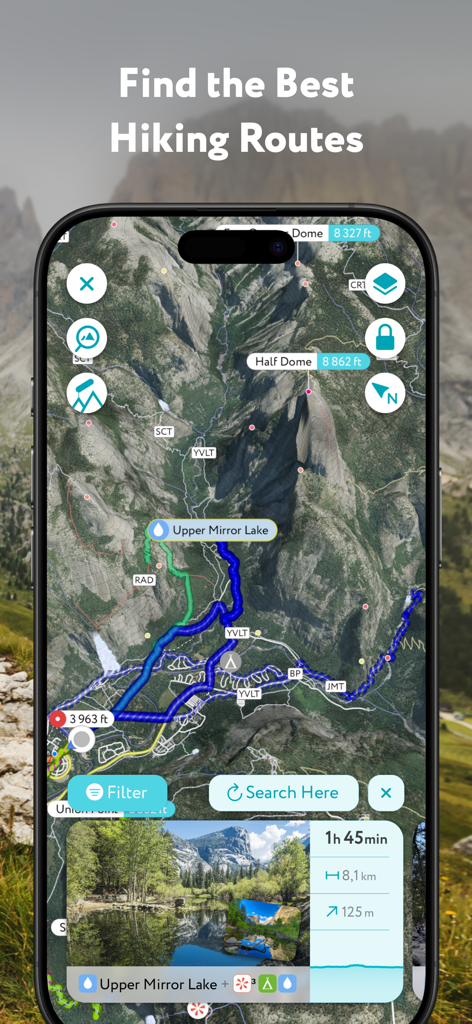
하프 돔의 3D 하이킹 경로와 산책로 정보를 표시하는 PeakVisor 모바일 앱
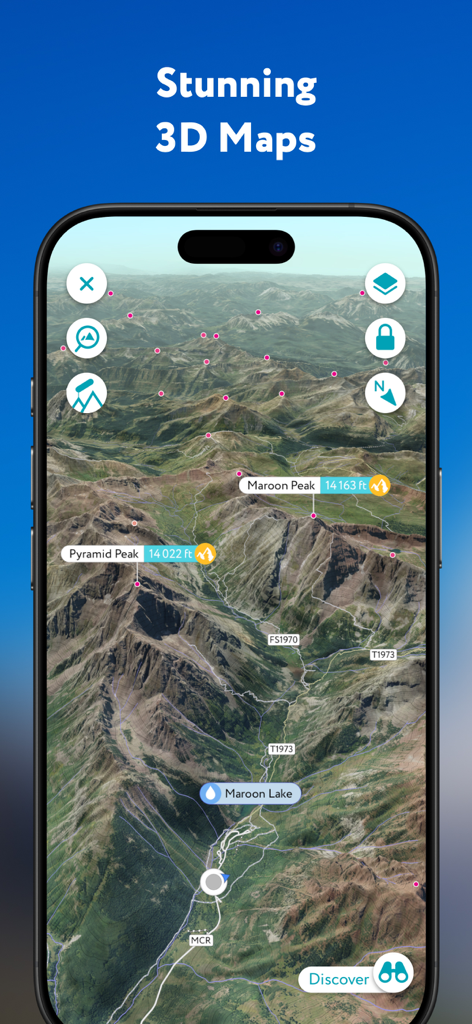
이름이 표시된 산봉우리와 하이킹 경로가 있는 고정밀 3D 지형도를 보여주는 PeakVisor 앱
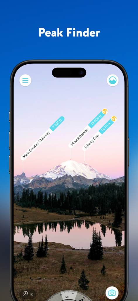
고도 태그와 함께 레이니어 산과 같은 산봉우리를 식별하는 PeakVisor 앱의 증강 현실 인터페이스
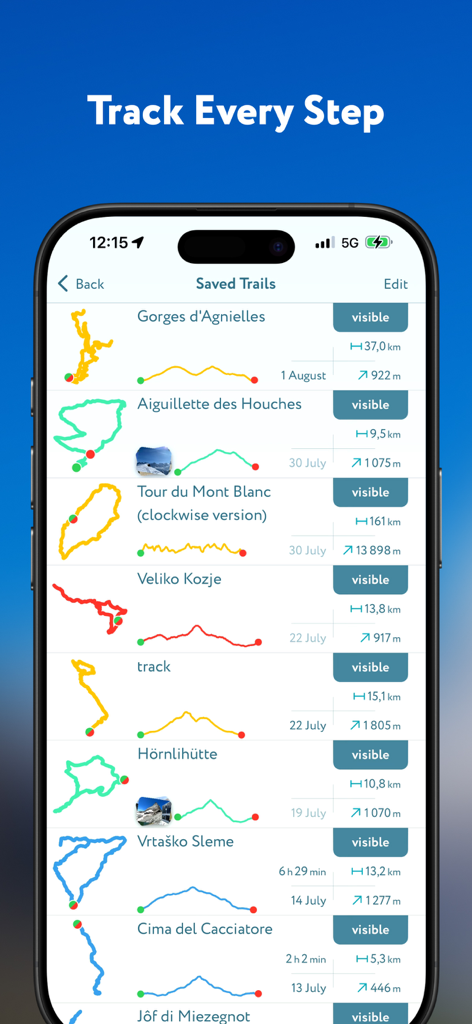
상세한 경로 지도와 고도 프로필이 포함된 저장된 하이킹 코스 목록을 보여주는 PeakVisor 앱 화면
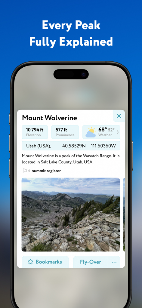
고도 돌출도와 날씨 데이터를 보여주는 PeakVisor 앱의 울버린 산 상세 프로필
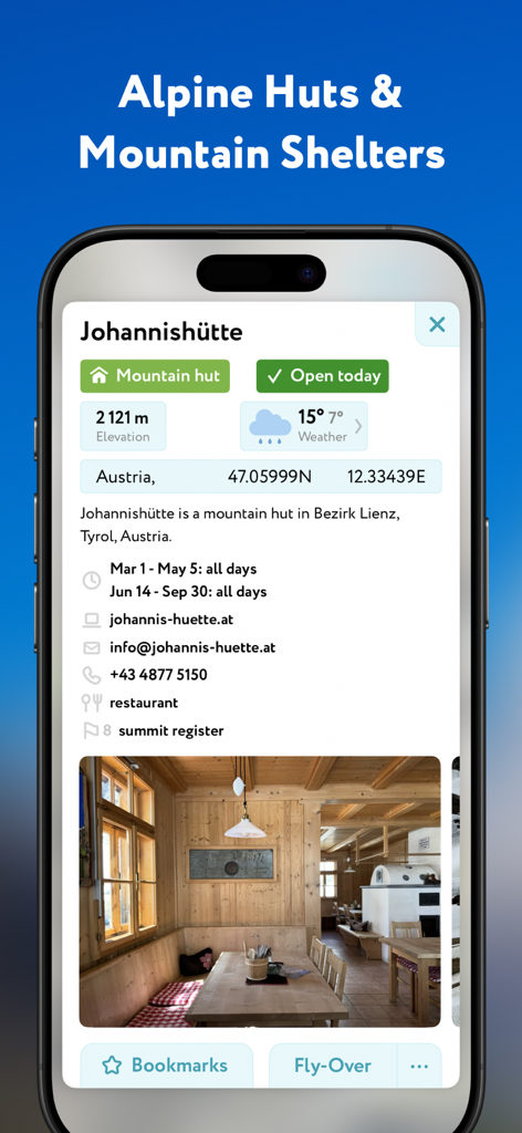
오스트리아 요하니스휘테 산장의 고도 및 날씨 정보와 함께 상세 정보를 보여주는 PeakVisor 앱 화면
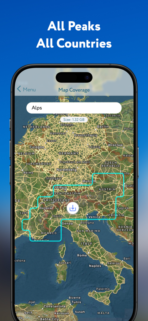
오프라인 산악 데이터 다운로드 옵션이 포함된 알프스 지도를 보여주는 PeakVisor 앱 화면
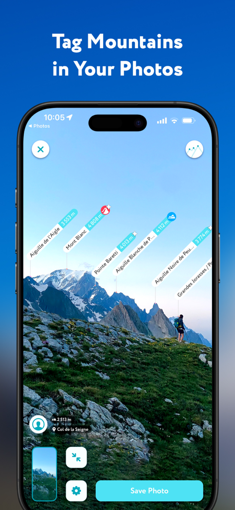
풍경 사진에 이름과 고도 태그가 표시된 산봉우리를 보여주는 PeakVisor 앱 인터페이스
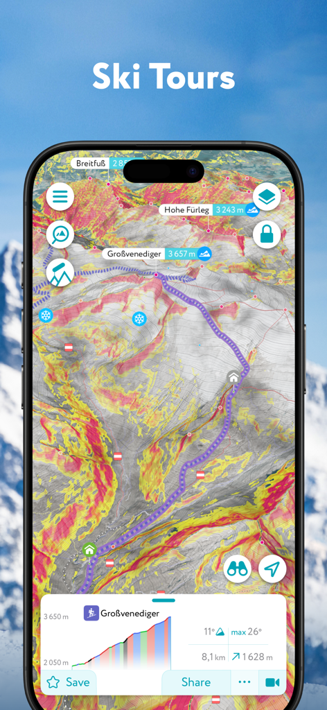
경사도 안전 오버레이와 함께 스키 투어 경로를 표시하는 PeakVisor 앱의 3D 지형도
설명
Download
비슷한 앱
유사한 기능과 사용자 경험을 가진 앱


이 페이지는 앱이나 개발자의 공식 페이지가 아니며, 정보 제공 및 논평을 목적으로 작성된 독립 편집 간행물입니다. 명시적으로 달리 언급되지 않는 한, 해당 앱이나 개발자는 MWM, Apple, Google Play, 앱 퍼블리셔 또는 앱 개발자와 제휴, 보증, 후원, 승인 또는 공식적으로 연결되어 있지 않으며, 이 페이지의 어떤 내용도 해당 앱이 MWM의 서비스를 사용하여 개발되었음을 의미하지 않습니다. 모든 상표, 로고, 스크린샷 및 기타 콘텐츠는 해당 소유자의 자산입니다.