이 페이지는 앱이나 개발자의 공식 페이지가 아니며, 정보 제공 및 논평을 목적으로 작성된 독립 편집 간행물입니다. 명시적으로 달리 언급되지 않는 한, 해당 앱이나 개발자는 MWM, Apple, Google Play, 앱 퍼블리셔 또는 앱 개발자와 제휴, 보증, 후원, 승인 또는 공식적으로 연결되어 있지 않으며, 이 페이지의 어떤 내용도 해당 앱이 MWM의 서비스를 사용하여 개발되었음을 의미하지 않습니다. 모든 상표, 로고, 스크린샷 및 기타 콘텐츠는 해당 소유자의 자산입니다.

Lowrance: app for anglers
고해상도 C-MAP 차트로 정밀하게 계획하고, 소파에서 조종석까지 웨이포인트를 손쉽게 동기화하세요. 더 많은 물고기를 찾고 자신 있게 항해하는 데 필요한 전문적인 이점을 얻으세요.
다운로드
600K+사용자 평점
총 평가 수
2K+개발사
카테고리
Navigation지원 언어
1최신 버전
2.5.4크기
176.0 MB출시일
2019년 10월 17일전문 정보로 모든 여행을 마스터하세요
스마트폰을 고출력 스카우팅 도구로 바꾸세요. 토너먼트 프로들이 사용하는 것과 동일한 정밀도와 데이터 깊이로 계획, 동기화 및 탐색하세요.
소파에서 조종석까지 계획
검색 시간을 줄이고 낚시 시간을 늘리세요. 집에서 사용자 지정 웨이포인트와 경로를 만든 다음 보트 디스플레이로 즉시 동기화하세요.
REVEAL 음영 처리된 지형
고해상도 수심 측량으로 경쟁 우위를 확보하세요. 업계 최고의 선명도로 1피트 등고선과 수중 구조물을 시각화하세요.
자주 묻는 질문
에 대해 알아야 할 모든 것 Lowrance: app for anglers
로렌스 앱이란 무엇인가요?
로렌스 앱은 상세한 C-MAP 지도를 제공하고, 웨이포인트 관리를 지원하며, 새로운 낚시 장소를 발견하고, 여행 계획을 용이하게 하는 낚시 동반자입니다. 더 나은 낚시 경험을 위해 로렌스 장치와 데이터를 원활하게 동기화합니다.
로렌스 앱은 웨이포인트를 어떻게 관리하는 데 도움이 되나요?
로렌스 앱을 통해 사용자는 웨이포인트와 낚시 장소를 생성, 저장, 편집 및 공유할 수 있습니다. 새로운 수역을 탐색하고 미리 여행을 계획할 수 있으며, 외딴 지역에서는 오프라인 지도 보기 기능도 제공합니다.
로렌스 앱은 어떤 지도 기능을 제공하나요?
로렌스 앱은 최신 C-MAP 지도와 함께 고해상도 수심측량, 사용자 정의 음영, 경사로 및 연료를 포함한 수천 개의 관심 지점을 제공합니다. 낚시 웨이포인트로 최적의 탐색을 위한 자동 경로 기능을 포함합니다.
로렌스 앱은 다른 장치와 동기화할 수 있나요?
네, 로렌스 앱은 호환되는 로렌스 장치와 웨이포인트, 낚시 장소 및 데이터를 동기화합니다. 이를 통해 사용자는 물 위에서나 물 밖에서나 앱과 해양 전자 장치 간의 데이터를 원활하게 전송할 수 있습니다.
어떤 로렌스 장치가 로렌스 앱과 호환되나요?
로렌스 앱은 Elite ti2, Elite FS, HDS Carbon, HDS Live 및 HDS Pro 장치와 호환됩니다. 이러한 장치는 직접 통합 기능을 위해 NOS 소프트웨어 버전 20.0 이상이 필요합니다.
로렌스 앱은 프리미엄 기능에 대한 무료 체험을 제공하나요?
네, 로렌스 앱은 프리미엄 기능에 대해 14일 무료 체험을 제공합니다. 덴마크와 스웨덴에서는 체험 기간이 3일입니다. 이를 통해 사용자는 구독하기 전에 고급 기능을 경험할 수 있습니다.
무료 로렌스 앱에는 어떤 기능이 포함되어 있나요?
무료 로렌스 앱에는 C-MAP 차트 뷰어, 자동 경로, 개인 웨이포인트, 트랙 기록, 수천 개의 POI, 해양 날씨 예보, 차트 개인화 및 GPX 파일 가져오기/내보내기 기능이 포함됩니다.
로렌스 앱 프리미엄을 통해 어떤 추가 기능을 사용할 수 있나요?
로렌스 앱 프리미엄은 전체 GPS 기능, 오프라인 지도 다운로드, REVEAL 음영 지형, 고해상도 수심측량, 사용자 정의 수심 음영, AIS 및 C-MAP 교통 정보를 잠금 해제합니다. 이러한 기능은 탐색 및 안전을 향상시킵니다.
로렌스 앱 프리미엄 구독에 대한 청구는 어떻게 되나요?
로렌스 앱 프리미엄 구독에 대한 결제는 구매 확인 시 iTunes 계정으로 청구됩니다. 구독은 기간 종료 24시간 전에 비활성화하지 않는 한 자동 갱신되며, 계정 청구는 갱신 전에 발생합니다.
로렌스 앱에서 트랙을 기록하고 경로를 만들 수 있나요?
네, 로렌스 앱을 사용하면 트랙을 기록하고 새 경로를 만들 수 있습니다. 이 기능은 이전 여행을 검토하고 낚시 탐험을 위한 미래 탐색 경로를 효율적으로 계획하는 데 도움이 됩니다.
로렌스 앱은 날씨 정보를 제공하나요?
네, 로렌스 앱은 해양 날씨 예보, 경로상의 날씨, 날씨 오버레이 기능 등 포괄적인 날씨 정보를 제공합니다. 이러한 도구는 사용자가 안전하고 효과적으로 여행을 계획하는 데 도움이 됩니다.
사용자는 로렌스 앱 구독을 어떻게 관리할 수 있나요?
사용자는 구매 후 계정 설정에 액세스하여 로렌스 앱 구독을 관리하고 자동 갱신을 비활성화할 수 있습니다. 이를 통해 구독 기본 설정에 대한 직접적인 제어를 제공합니다.
다음 스크린샷과 설명은 앱의 공식 스토어 목록에서 직접 가져온 것이며 앱 개발자의 자산입니다.
앱 스토어
스크린샷
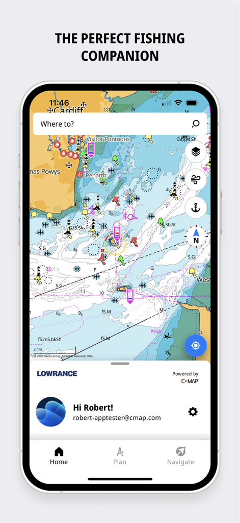
Lowrance 앱 인터페이스가 낚시 웨이포인트 및 탐색 도구가 있는 상세한 해도에 표시됨
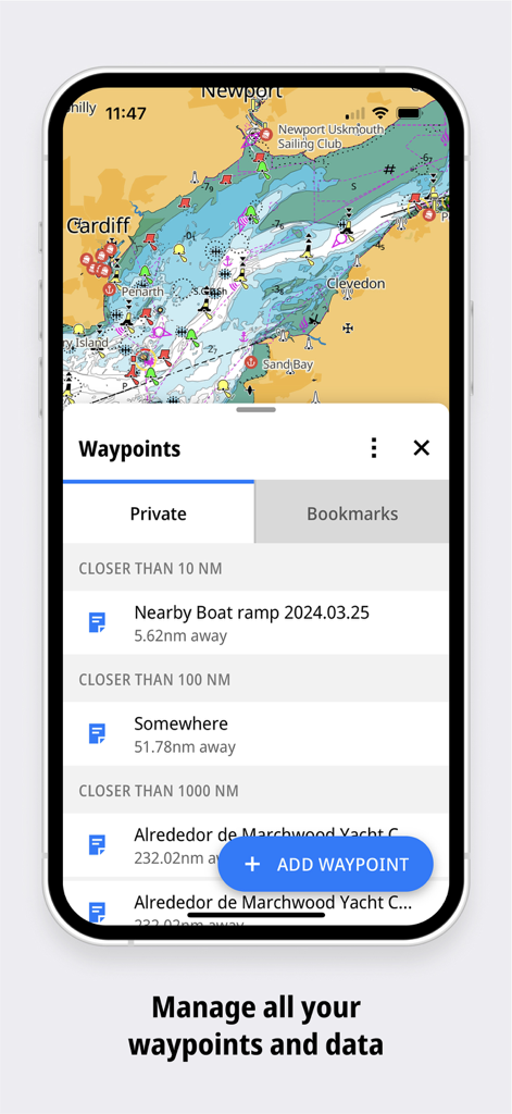
Lowrance 앱의 모바일 인터페이스가 낚시 웨이포인트 및 보트 경사로 관리를 위한 팝업 목록과 함께 해상 탐색 지도를 보여줌
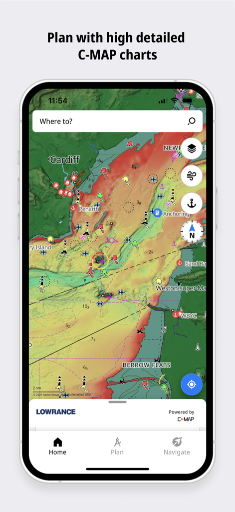
낚시 여행 계획을 위한 매우 상세한 C-MAP 차트 및 수심 측량 데이터가 있는 Lowrance 앱을 보여주는 모바일 화면
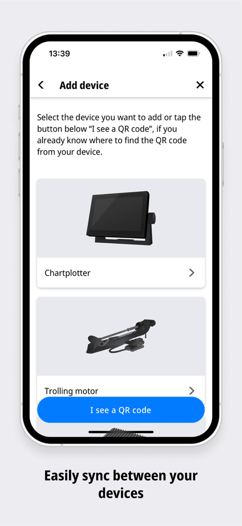
차트플로터 및 트롤링 모터 하드웨어 동기화 옵션이 있는 Lowrance 앱 장치 추가 메뉴를 보여주는 iPhone 화면
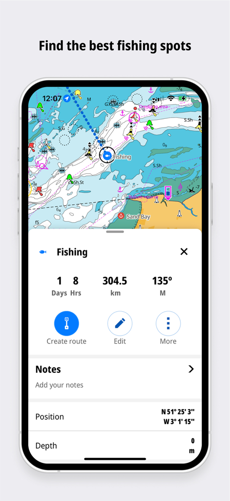
낚시 웨이포인트 세부 정보 및 탐색 옵션이 있는 해상 지도를 보여주는 Lowrance 앱 스크린샷
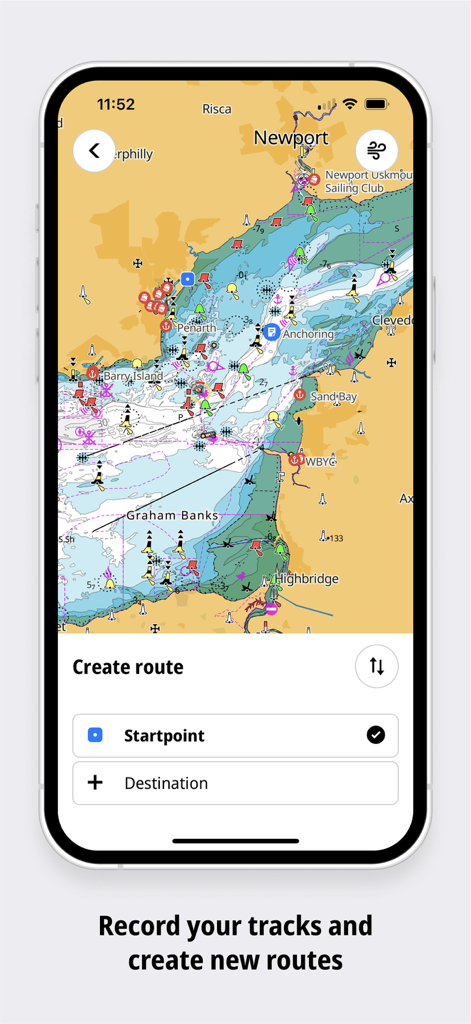
상세한 해도에 낚시 경로를 만드는 Lowrance 앱 인터페이스.
설명
Download
비슷한 앱
유사한 기능과 사용자 경험을 가진 앱

dēzl™
Garmin International

ActiveCaptain®
Garmin International

Fusion Audio
Garmin International

NMEAremote
zapfware

RayControl
Raymarine Belgium BVBA

One-Boat Network
Johnson Outdoors Inc

iAIS
Digital Yacht Ltd

Raymarine
Raymarine UK Limited

Boat Instruments
Imray, Laurie, Norie & Wilson LTD
이 페이지는 앱이나 개발자의 공식 페이지가 아니며, 정보 제공 및 논평을 목적으로 작성된 독립 편집 간행물입니다. 명시적으로 달리 언급되지 않는 한, 해당 앱이나 개발자는 MWM, Apple, Google Play, 앱 퍼블리셔 또는 앱 개발자와 제휴, 보증, 후원, 승인 또는 공식적으로 연결되어 있지 않으며, 이 페이지의 어떤 내용도 해당 앱이 MWM의 서비스를 사용하여 개발되었음을 의미하지 않습니다. 모든 상표, 로고, 스크린샷 및 기타 콘텐츠는 해당 소유자의 자산입니다.