이 페이지는 앱이나 개발자의 공식 페이지가 아니며, 정보 제공 및 논평을 목적으로 작성된 독립 편집 간행물입니다. 명시적으로 달리 언급되지 않는 한, 해당 앱이나 개발자는 MWM, Apple, Google Play, 앱 퍼블리셔 또는 앱 개발자와 제휴, 보증, 후원, 승인 또는 공식적으로 연결되어 있지 않으며, 이 페이지의 어떤 내용도 해당 앱이 MWM의 서비스를 사용하여 개발되었음을 의미하지 않습니다. 모든 상표, 로고, 스크린샷 및 기타 콘텐츠는 해당 소유자의 자산입니다.

다운로드
61K+사용자 평점
총 평가 수
0개발사
카테고리
Weather지원 언어
-최신 버전
3.0.1크기
60.6 MB출시일
2020년 12월 18일진지한 항해사를 위한 정밀 기압계
iPhone 또는 iPad를 전문 등급의 해양 기기로 변환하세요. 고정밀 기압 추세를 추적하고, 항해 데이터를 기록하고, 해상에서 신뢰할 수 있는 안정성으로 날씨보다 앞서 나가세요.
고급 기압 경향 추적
최대 16일간의 과거 데이터를 시각화하고 공식 기압 경향 코드를 계산하여 폭풍 전선이 현재 위치에 도달하기 전에 감지하세요.
자동 항해 기록
대기압, GPS 위치 및 속도를 백그라운드에서 안전하게 기록하세요. 전문 내비게이션 소프트웨어를 위해 전체 항해 경로를 GPX 파일로 내보내세요.
자주 묻는 질문
에 대해 알아야 할 모든 것 Marine Barograph
Marine Barograph 앱이란 무엇인가요?
Marine Barograph 앱은 해상 및 육상 여행을 위한 향상된 기압계입니다. 기압, GPS 데이터, 코스, 속도를 자동으로 저장하여 상세한 압력 추세 분석 및 내보내기 기능을 제공합니다.
Marine Barograph 앱은 기압 데이터를 자동으로 기록하나요?
예, Marine Barograph 앱은 기압 데이터를 자동으로 저장합니다. 백그라운드에서 실행 중일 때도 압력, 시간, 날짜, GPS 위치, 이동 코스, 이동 속도를 기록합니다.
Marine Barograph 앱은 기압 데이터를 얼마나 오래 그래프로 표시할 수 있나요?
Marine Barograph 앱은 다양한 시간 간격으로 압력 데이터를 그래프로 표시할 수 있습니다. 30분부터 최대 16일까지의 기간을 제공하여 포괄적인 추세 분석이 가능합니다.
Marine Barograph 앱에서 수집된 데이터를 볼 수 있나요?
예, Marine Barograph 앱 내에서 저장된 데이터를 직접 볼 수 있습니다. 항해 또는 육상 여행 기록과 함께 내비게이션 정보 및 압력 데이터가 표시됩니다.
Marine Barograph 앱에서 데이터를 어떻게 내보낼 수 있나요?
Marine Barograph 앱을 사용하면 저장된 압력 데이터와 GPS 트랙을 내보낼 수 있습니다. 압력 데이터는 시간 범위별로 내보낼 수 있으며, GPS 위치는 GPX 파일로 내보낼 수 있습니다.
Marine Barograph는 압력 추세 화살표를 표시하나요?
예, Marine Barograph 앱은 눈에 띄는 압력 추세 화살표를 표시합니다. 이 화살표는 지난 1시간 동안의 변화를 기반으로 압력 추세를 나타내어 날씨 분석에 도움이 됩니다.
Marine Barograph 앱은 데이터를 무선으로 공유할 수 있나요?
예, Marine Barograph 앱은 압력 및 위치 정보를 모두 무선으로 공유합니다. 사용자가 선택한 포트에서 WIFI를 통해 UDP 모드로 데이터를 브로드캐스트하여 다른 내비게이션 시스템의 소스 역할을 합니다.
Marine Barograph에서 압력 표시 옵션은 무엇인가요?
Marine Barograph 앱은 압력 표시 옵션을 제공합니다. 사용자는 해수면 압력 또는 현지 압력을 선택할 수 있으며, 설정에서 정밀도와 위도 및 경도 형식을 조정할 수 있습니다.
기존 iPhone을 Marine Barograph 앱으로 전용 기압계로 사용할 수 있나요?
예, Marine Barograph 앱은 구형 iPhone(iPhone 6 이상)을 유용한 독립형 전자 기압계 및 항해 데이터 로거로 변환할 수 있습니다. 연결되어 있을 때 연속적인 보기를 제공합니다.
Marine Barograph 앱에 도움말 파일이 포함되어 있나요?
예, Marine Barograph 앱에는 전체 도움말 파일이 포함되어 있습니다. 작동 방법을 자세히 설명하고 내비게이션을 위해 대기압을 사용하는 방법에 대한 팁을 제공하며, 온라인에서도 볼 수 있습니다.
다음 스크린샷과 설명은 앱의 공식 스토어 목록에서 직접 가져온 것이며 앱 개발자의 자산입니다.
앱 스토어
스크린샷
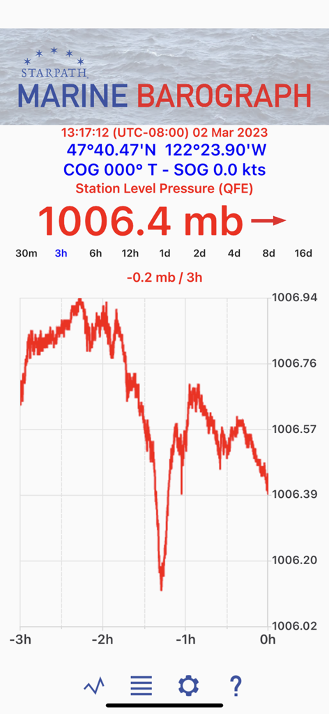
Marine Barograph 앱 디스플레이에 실시간 대기압 추세 및 GPS 좌표 표시
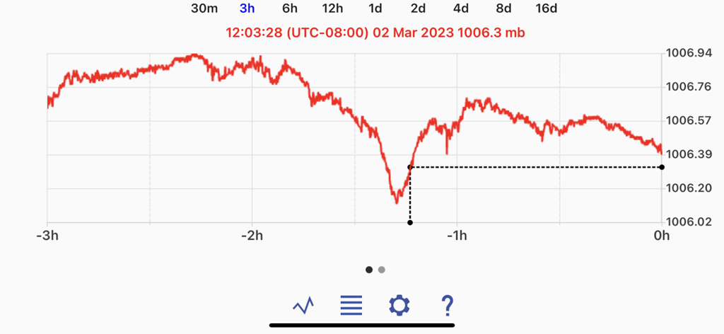
Marine Barograph 앱 디스플레이에 3시간 대기압 이력 그래프 표시
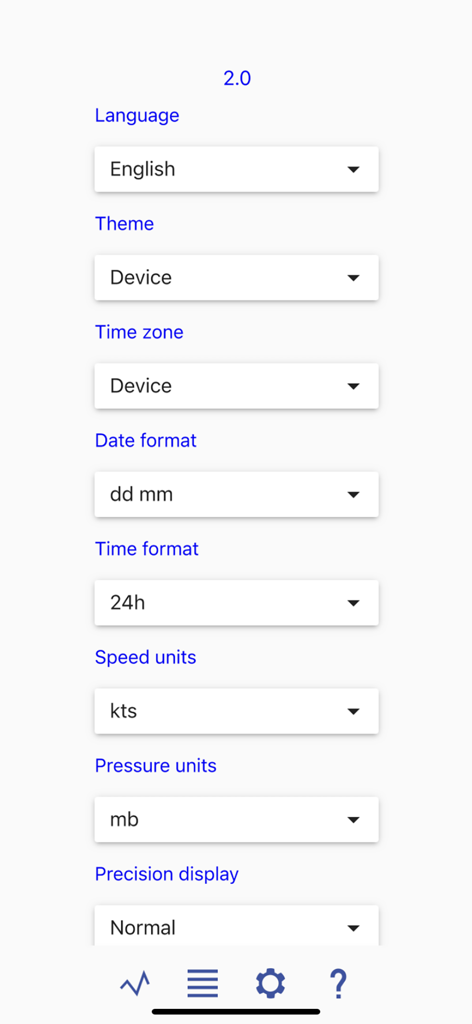
Marine Barograph 앱 설정 메뉴에 언어, 시간대 및 측정 단위 구성 옵션 표시

Marine Barograph 앱 설정 메뉴에 기압 및 위치 구성 표시
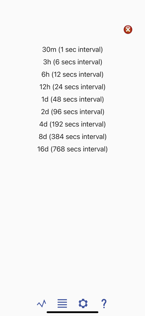
Marine Barograph 앱의 시간 및 기압 기록 간격 목록
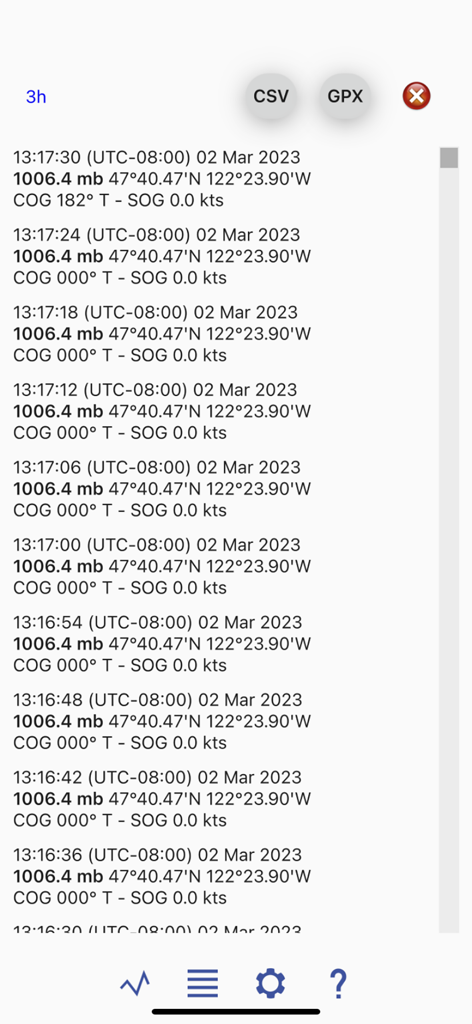
Marine Barograph 앱의 기압 및 GPS 내비게이션 데이터 상세 로그
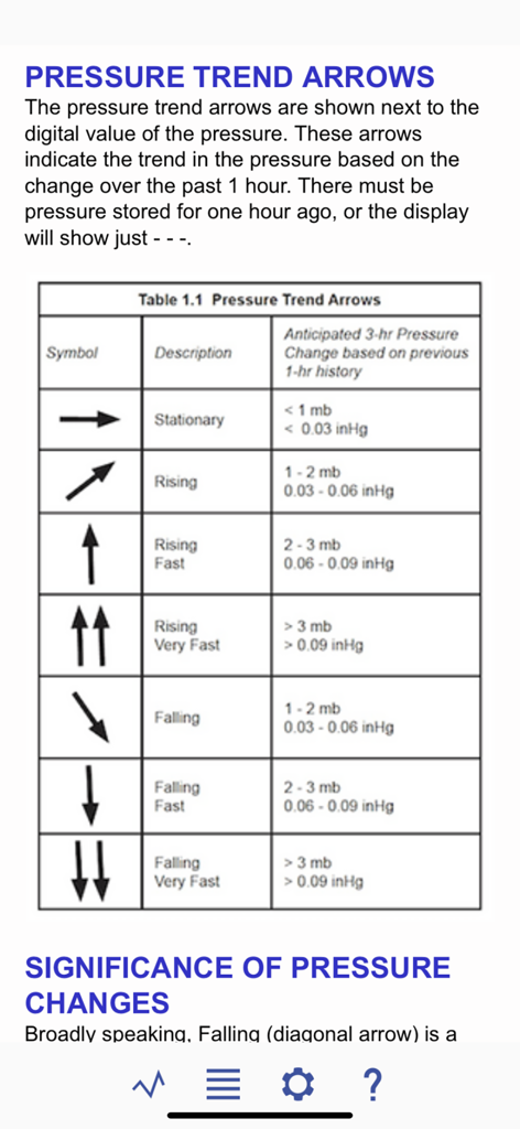
Marine Barograph 앱의 대기압 경향 화살표 의미를 설명하는 차트
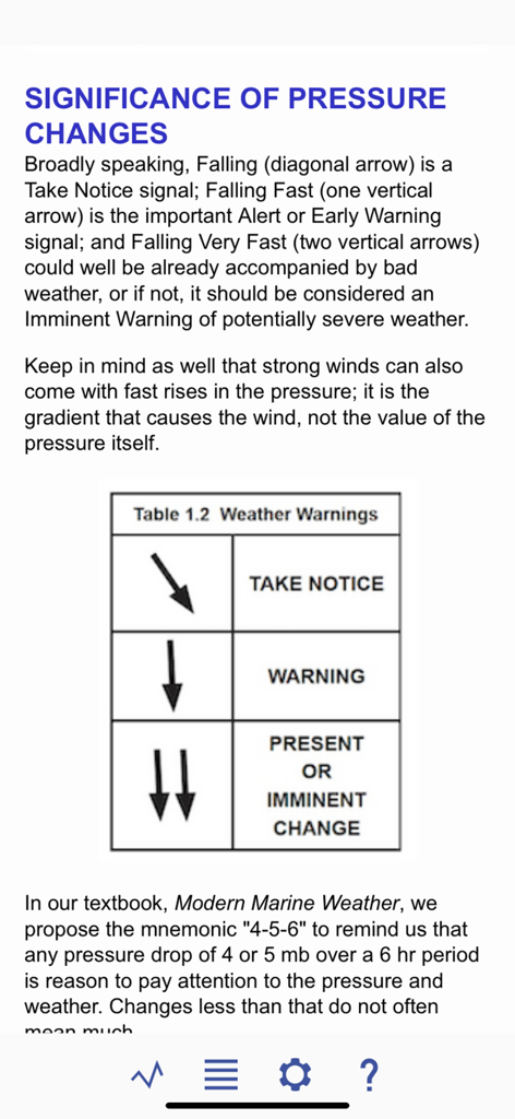
날씨 경고 표와 함께 기압 변화의 중요성을 설명하는 Marine Barograph 앱의 도움말 화면.
설명
Download
비슷한 앱
같은 카테고리의 상위 앱

墨迹天气-MojiWeather
Beijing MojiFengyun Technology Co.,Ltd.

The Weather Channel - Radar
The Weather Channel

Windy.com
Windyty, SE

天气预报-精准15日天气预报
Chongqing Caochen Technology Co., Ltd.

My Aurora Forecast & Alerts
JRustonApps B.V.

AccuWeather: Weather Forecast
AccuWeather International, Inc.

Weather & Radar - Storm radar
WetterOnline - Meteorologische Dienstleistungen GmbH

天气通
Weibo Internet Technology (China) Co.Ltd.

The Thermometer -Digital-
Vida Apps Incorporated
이 페이지는 앱이나 개발자의 공식 페이지가 아니며, 정보 제공 및 논평을 목적으로 작성된 독립 편집 간행물입니다. 명시적으로 달리 언급되지 않는 한, 해당 앱이나 개발자는 MWM, Apple, Google Play, 앱 퍼블리셔 또는 앱 개발자와 제휴, 보증, 후원, 승인 또는 공식적으로 연결되어 있지 않으며, 이 페이지의 어떤 내용도 해당 앱이 MWM의 서비스를 사용하여 개발되었음을 의미하지 않습니다. 모든 상표, 로고, 스크린샷 및 기타 콘텐츠는 해당 소유자의 자산입니다.