이 페이지는 앱이나 개발자의 공식 페이지가 아니며, 정보 제공 및 논평을 목적으로 작성된 독립 편집 간행물입니다. 명시적으로 달리 언급되지 않는 한, 해당 앱이나 개발자는 MWM, Apple, Google Play, 앱 퍼블리셔 또는 앱 개발자와 제휴, 보증, 후원, 승인 또는 공식적으로 연결되어 있지 않으며, 이 페이지의 어떤 내용도 해당 앱이 MWM의 서비스를 사용하여 개발되었음을 의미하지 않습니다. 모든 상표, 로고, 스크린샷 및 기타 콘텐츠는 해당 소유자의 자산입니다.

Moon Phase Photo Maps
이상화된 다이어그램 대신 실제 고해상도 달 위상 사진 30장을 사용하세요. 반전된 지도로 망원경의 방향을 맞추고, 종료선(terminator)을 따라 상세한 분화구, 계곡, 골짜기를 발견하세요.
다운로드
69K+사용자 평점
총 평가 수
0개발사
카테고리
Reference지원 언어
1최신 버전
1.5크기
62.5 MB출시일
2011년 1월 13일진지한 관측자를 위한 정밀 지도
망원경 및 쌍안경 사용자를 위해 특별히 설계된 기술 도구와 고해상도 사진을 통해 달을 경험하세요.
실제 달 사진
스타일화된 다이어그램과 비교하여 실제와 같은 참조를 제공하는 30장의 실제 달 위상 사진을 사용하여 특징을 식별하세요.
망원경용 방향 설정
망원경의 광학 장치에 맞게 시야를 즉시 뒤집거나 반전하여 화면에서 보는 것과 접안 렌즈에서 보는 것이 정확히 일치하도록 합니다.
다음 스크린샷과 설명은 앱의 공식 스토어 목록에서 직접 가져온 것이며 앱 개발자의 자산입니다.
앱 스토어
스크린샷
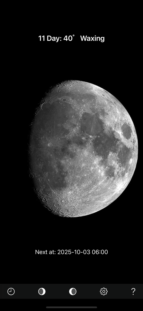
달 위상 사진 지도 앱의 초승달 위상(11일차) 실제 사진을 표시하는 스크린샷
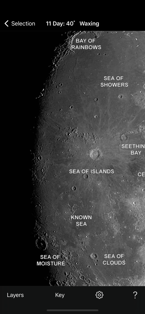
달 위상 사진 지도 앱에서 레이블이 지정된 달 바다와 분화구가 있는 달 표면의 상세 사진
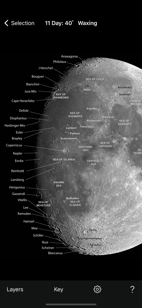
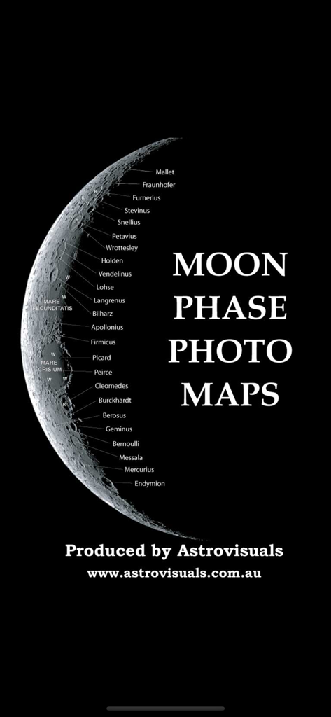
레이블이 지정된 분화구와 달 바다가 있는 초승달의 상세 사진 지도
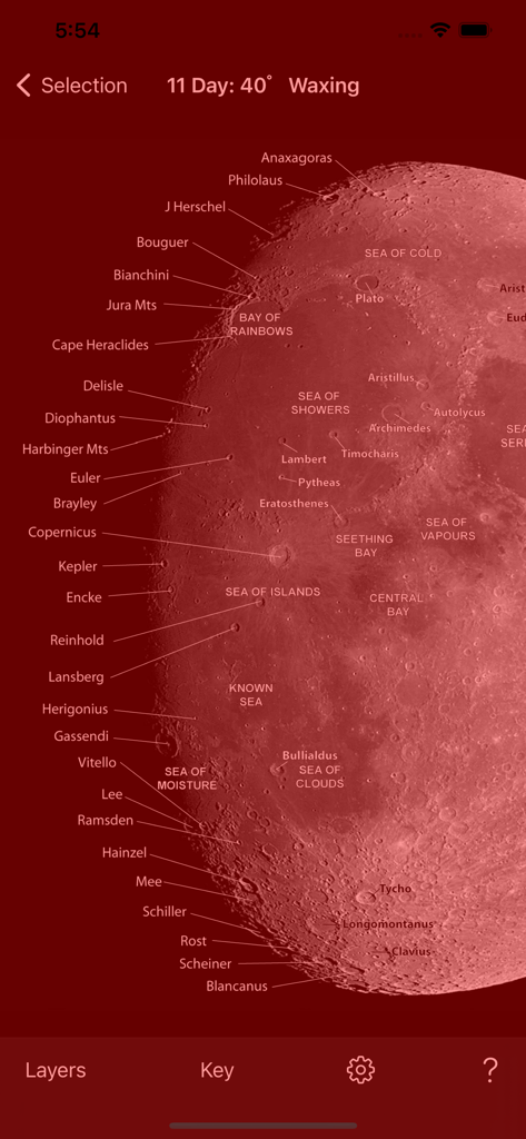
밤 모드에서 레이블이 지정된 분화구와 특징이 있는 달의 사진 지도
다양한 달 분화구와 특징에 레이블이 지정된 초승달 사진
설명
Download
비슷한 앱
같은 카테고리의 상위 앱

Google Translate
Google LLC

火箭沙盒
P2E CO., LTD.

Bible
Life.Church

Youdao Dictionary
Beijing NetEase Youdao Computer System Co.,Ltd

Bible Chat: Daily Devotional
Book Vitals Inc.

Naver Papago - AI Translator
NAVER Corp.

Translate Now - AI Translator
AIR APPS SYSTEMS, UNIPESSOAL, LDA

Lok l0k: Watch Drama TV,Movies
Olivia Harris

Live Translator - AI Translate
DigitalSail (HK) Limited
이 페이지는 앱이나 개발자의 공식 페이지가 아니며, 정보 제공 및 논평을 목적으로 작성된 독립 편집 간행물입니다. 명시적으로 달리 언급되지 않는 한, 해당 앱이나 개발자는 MWM, Apple, Google Play, 앱 퍼블리셔 또는 앱 개발자와 제휴, 보증, 후원, 승인 또는 공식적으로 연결되어 있지 않으며, 이 페이지의 어떤 내용도 해당 앱이 MWM의 서비스를 사용하여 개발되었음을 의미하지 않습니다. 모든 상표, 로고, 스크린샷 및 기타 콘텐츠는 해당 소유자의 자산입니다.