이 페이지는 앱이나 개발자의 공식 페이지가 아니며, 정보 제공 및 논평을 목적으로 작성된 독립 편집 간행물입니다. 명시적으로 달리 언급되지 않는 한, 해당 앱이나 개발자는 MWM, Apple, Google Play, 앱 퍼블리셔 또는 앱 개발자와 제휴, 보증, 후원, 승인 또는 공식적으로 연결되어 있지 않으며, 이 페이지의 어떤 내용도 해당 앱이 MWM의 서비스를 사용하여 개발되었음을 의미하지 않습니다. 모든 상표, 로고, 스크린샷 및 기타 콘텐츠는 해당 소유자의 자산입니다.

Navitel Navigator
66개국을 완벽한 오프라인 독립성으로 탐색하세요. 대형 차량을 위한 전문 화물 경로 설정부터 프리미엄 헤드업 디스플레이 기술까지, 신호가 필요 없는 어디든 전문가 수준의 정밀도를 얻으십시오.
다운로드
1M+사용자 평점
총 평가 수
3K+개발사
카테고리
Navigation지원 언어
36최신 버전
12.6.1433크기
93.8 MB출시일
2013년 3월 5일열정적인 전문가를 위한 정밀 내비게이션
주 경계를 넘어 화물을 운송하든 국제 도시를 탐험하든, Navitel Navigator는 표준 앱이 따라올 수 없는 오프라인 신뢰성과 전문적인 경로 설정을 제공합니다.
데이터 제로 신뢰성
고해상도 오프라인 지도로 66개국을 탐색하세요. 농촌의 통신 음영 지역에서도 길을 잃지 않고 100% 자율 GPS로 국제 로밍 요금을 피하세요.
전문 화물 로직
3.5톤에서 40톤 이상의 대형 차량을 위해 제작되었습니다. 무게 제한, 교량 높이 및 상업용 도로 제한을 자동으로 준수하는 경로를 계획하세요.
자주 묻는 질문
에 대해 알아야 할 모든 것 Navitel Navigator
Does Navitel Navigator support offline maps?
네, Navitel Navigator는 오프라인 지도를 지원합니다. 사용자는 66개국 지도를 다운로드하여 인터넷 연결 없이 사용할 수 있으므로 로밍 비용을 절약하고 통신이 원활하지 않은 지역에서도 내비게이션을 보장받을 수 있습니다.
Does Navitel Navigator support Apple CarPlay?
네, Navitel Navigator는 Apple CarPlay를 지원합니다. 사용자는 차량의 헤드 유닛에 내비게이션을 표시하고 사용할 수 있어 원활한 차량 내 경험을 제공합니다.
Does Navitel Navigator provide real-time traffic information?
네, Navitel Navigator는 Navitel.Traffic을 통해 실시간 교통 정보를 제공합니다. 교통 체증, 사고, 도로 공사 및 기타 사건을 표시하여 경로를 최적화하는 데 도움을 줍니다.
Does Navitel Navigator offer navigation for trucks?
네, Navitel Navigator는 트럭용 Cargo 그래프 기능을 제공합니다. 3.5~40톤 이상의 차량에 대한 도로 표지판과 특정 제한 사항을 고려하여 경로를 생성하며, 사용자 정의 트럭 매개변수도 포함됩니다.
Does Navitel Navigator warn about speed cameras and radars?
네, Navitel Navigator는 SpeedCam 경고를 제공합니다. 레이더, 과속 카메라 및 도로 제한에 대해 사용자에게 알림으로써 운전 안전과 인식을 향상시킵니다.
How many alternative routes does Navitel Navigator suggest?
Navitel Navigator는 세 가지 대체 경로를 제안합니다. 각 경로는 거리 및 예상 이동 시간에 대한 자세한 정보를 포함하여 사용자가 가장 적합한 옵션을 선택할 수 있습니다.
Does Navitel Navigator display maps in 3D?
네, Navitel Navigator는 3D로 지도를 표시합니다. 텍스처와 건물 높이가 포함된 3D 지도를 제공하며, 다층 도로 교차로도 3D 모드로 표시합니다.
How can I contact support for Navitel Navigator?
사용자는 support@navitel.cz로 이메일을 보내 Navitel Navigator 지원팀에 문의할 수 있습니다. 지원팀은 애플리케이션에 대한 모든 질문이나 문제에 대해 도움을 드립니다.
다음 스크린샷과 설명은 앱의 공식 스토어 목록에서 직접 가져온 것이며 앱 개발자의 자산입니다.
앱 스토어
스크린샷
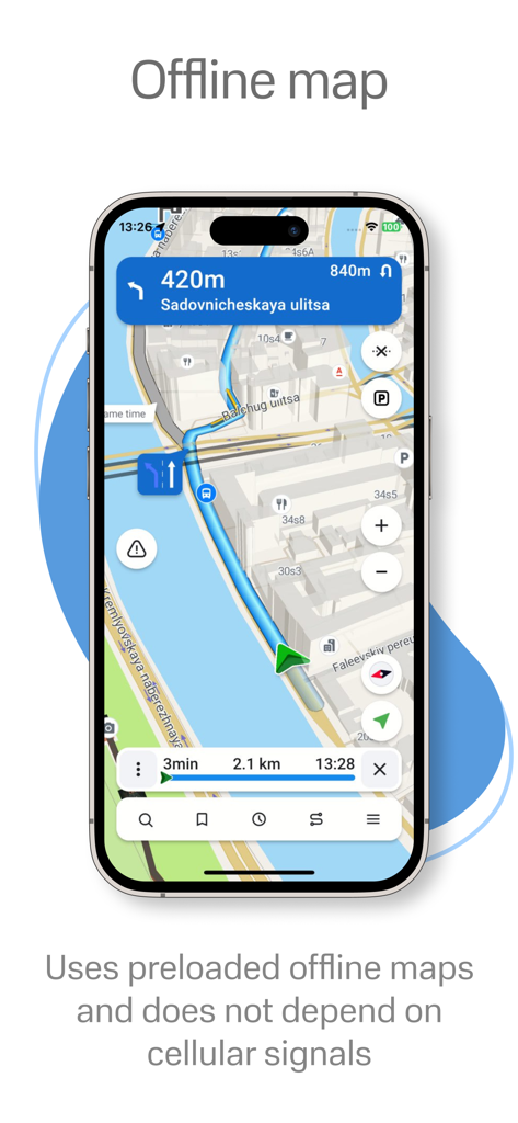
Navitel Navigator 앱이 스마트폰에서 오프라인 3D 내비게이션 및 경로 안내를 표시합니다.
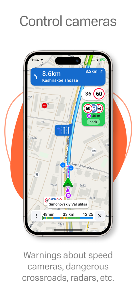
Navitel Navigator 앱 인터페이스가 속도 카메라 및 레이더 경고와 함께 내비게이션 지도를 표시합니다.
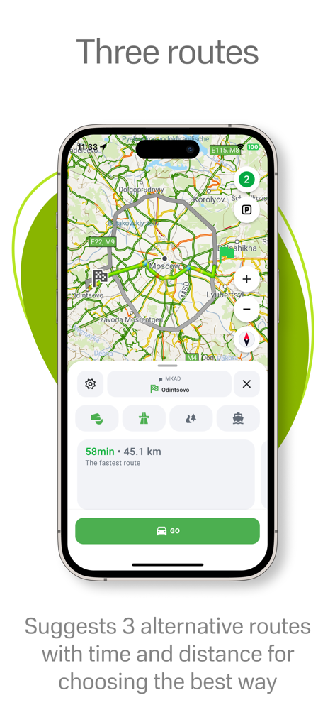
Navitel Navigator 앱이 시간 및 거리 세부 정보가 포함된 세 가지 대체 경로를 표시합니다.
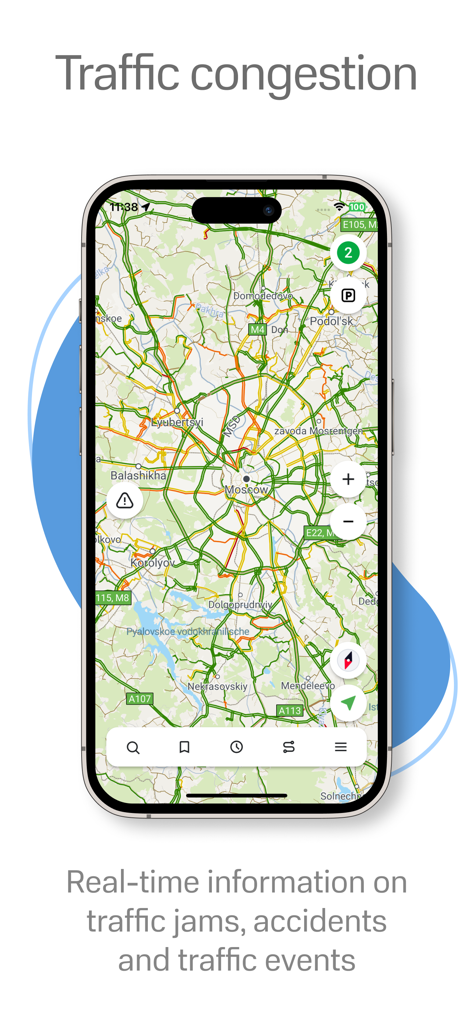
Navitel Navigator 지도에서 실시간 교통 체증 및 사고 경고.
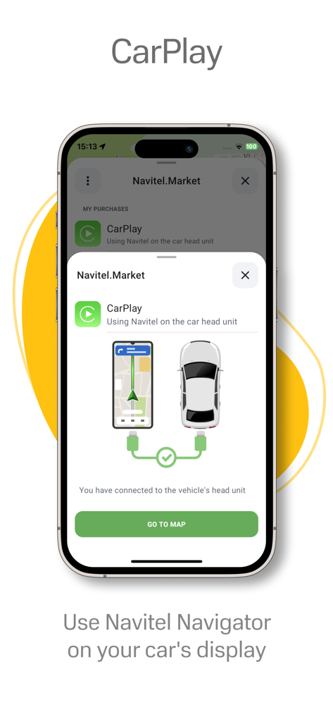
Navitel Navigator 앱 인터페이스가 차량 대시보드 내비게이션을 위해 CarPlay 통합을 표시합니다.
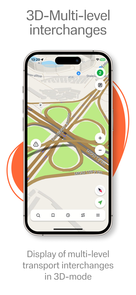
Navitel Navigator 앱이 iPhone에서 3D 모드로 상세한 다층 도로 교차로를 표시합니다.
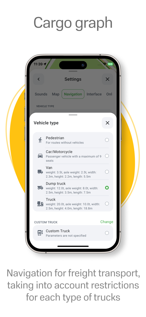
Navitel Navigator 앱이 전문 트럭 내비게이션을 위해 화물 그래프 차량 유형 선택을 표시합니다.
설명
Download
비슷한 앱
유사한 기능과 사용자 경험을 가진 앱

MAPS.ME: Offline Maps, GPS Nav
Convexity Holdings AG

CoMaps
Anton Wenemoser

GPS Navigation & Path Finder
Muhammad Asad Khan

MapFactor Navigator - GPS Maps
MAPFACTOR, s.r.o.

Guru Maps Pro & GPS Tracker
Evgen Bodunov

Offline Map Navigation
virtualmaze

Karta GPS - Offline Maps Nav
Karta Software Technologies lda

Genius Maps: GPS Navigation
Mireo d.d.

NaviMaps: 3D GPS Navigation
CE Info Systems Limited
이 페이지는 앱이나 개발자의 공식 페이지가 아니며, 정보 제공 및 논평을 목적으로 작성된 독립 편집 간행물입니다. 명시적으로 달리 언급되지 않는 한, 해당 앱이나 개발자는 MWM, Apple, Google Play, 앱 퍼블리셔 또는 앱 개발자와 제휴, 보증, 후원, 승인 또는 공식적으로 연결되어 있지 않으며, 이 페이지의 어떤 내용도 해당 앱이 MWM의 서비스를 사용하여 개발되었음을 의미하지 않습니다. 모든 상표, 로고, 스크린샷 및 기타 콘텐츠는 해당 소유자의 자산입니다.