이 페이지는 앱이나 개발자의 공식 페이지가 아니며, 정보 제공 및 논평을 목적으로 작성된 독립 편집 간행물입니다. 명시적으로 달리 언급되지 않는 한, 해당 앱이나 개발자는 MWM, Apple, Google Play, 앱 퍼블리셔 또는 앱 개발자와 제휴, 보증, 후원, 승인 또는 공식적으로 연결되어 있지 않으며, 이 페이지의 어떤 내용도 해당 앱이 MWM의 서비스를 사용하여 개발되었음을 의미하지 않습니다. 모든 상표, 로고, 스크린샷 및 기타 콘텐츠는 해당 소유자의 자산입니다.

RWIS
인프라 전문가를 위해 설계된 실시간 도로 노면 상태, 조기 결빙 경보 및 실시간 현장 서비스 추적을 통해 의사 결정을 강화하세요.
다운로드
23K+사용자 평점
총 평가 수
0개발사
카테고리
Weather지원 언어
11최신 버전
4.1.1크기
34.0 MB출시일
2014년 7월 25일주머니 속 운영 지휘소
인프라 전문가를 위해 구축된 실시간 도로 상태, 실시간 차량 추적 및 초단거리 센서 데이터를 통해 겨울철 날씨에 대한 대응을 간소화하세요.
초단거리 도로 정보
정밀 센서 데이터를 사용하여 도로 노면 온도, 수심 및 결빙 위험을 모니터링하여 필요한 경우에만 도로를 처리하세요.
실시간 차량 조정
총체적인 적용 범위와 운영 투명성을 보장하기 위해 인터랙티브 지도에서 활성 차량 및 색상 코딩된 개입 경로를 추적하세요.
다음 스크린샷과 설명은 앱의 공식 스토어 목록에서 직접 가져온 것이며 앱 개발자의 자산입니다.
앱 스토어
스크린샷
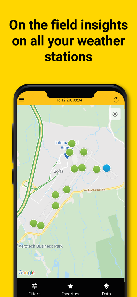
RWIS 앱 인터페이스가 공항 지도에 기상 관측소 위치를 보여주고 있습니다.

RWIS 모바일 앱 인터페이스가 인터랙티브 도시 지도에 실시간 차량 경로 추적을 보여주고 있습니다.

RWIS 앱 지도 보기에서 bMoves 개입을 위한 색상 코딩된 차량 경로 및 실시간 차량 추적을 보여줍니다.
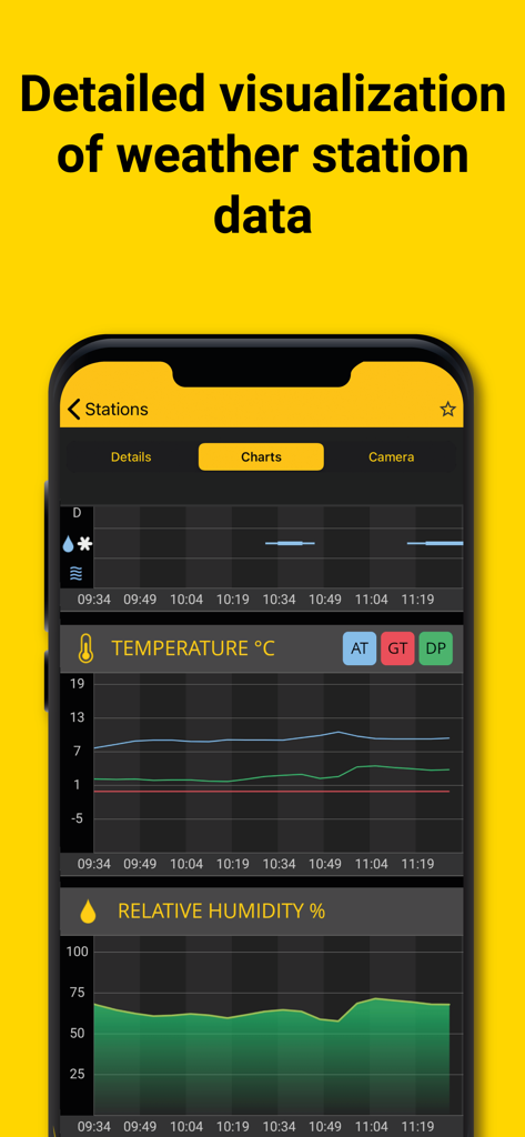
RWIS 앱이 도로 날씨 관측소 모니터링을 위한 실시간 온도 및 상대 습도 그래프를 표시하고 있습니다.
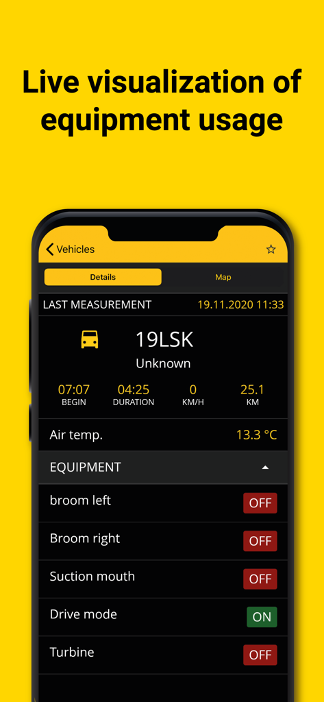
RWIS 앱 대시보드에서 도로 유지보수를 위한 실시간 장비 상태 및 차량 데이터를 보여줍니다.
설명
Download
비슷한 앱
같은 카테고리의 상위 앱

墨迹天气-MojiWeather
Beijing MojiFengyun Technology Co.,Ltd.

The Weather Channel - Radar
The Weather Channel

Windy.com
Windyty, SE

天气预报-精准15日天气预报
Chongqing Caochen Technology Co., Ltd.

My Aurora Forecast & Alerts
JRustonApps B.V.

AccuWeather: Weather Forecast
AccuWeather International, Inc.

Weather & Radar - Storm radar
WetterOnline - Meteorologische Dienstleistungen GmbH

天气通
Weibo Internet Technology (China) Co.Ltd.

The Thermometer -Digital-
Vida Apps Incorporated
이 페이지는 앱이나 개발자의 공식 페이지가 아니며, 정보 제공 및 논평을 목적으로 작성된 독립 편집 간행물입니다. 명시적으로 달리 언급되지 않는 한, 해당 앱이나 개발자는 MWM, Apple, Google Play, 앱 퍼블리셔 또는 앱 개발자와 제휴, 보증, 후원, 승인 또는 공식적으로 연결되어 있지 않으며, 이 페이지의 어떤 내용도 해당 앱이 MWM의 서비스를 사용하여 개발되었음을 의미하지 않습니다. 모든 상표, 로고, 스크린샷 및 기타 콘텐츠는 해당 소유자의 자산입니다.