이 페이지는 앱이나 개발자의 공식 페이지가 아니며, 정보 제공 및 논평을 목적으로 작성된 독립 편집 간행물입니다. 명시적으로 달리 언급되지 않는 한, 해당 앱이나 개발자는 MWM, Apple, Google Play, 앱 퍼블리셔 또는 앱 개발자와 제휴, 보증, 후원, 승인 또는 공식적으로 연결되어 있지 않으며, 이 페이지의 어떤 내용도 해당 앱이 MWM의 서비스를 사용하여 개발되었음을 의미하지 않습니다. 모든 상표, 로고, 스크린샷 및 기타 콘텐츠는 해당 소유자의 자산입니다.

Satellite Tracker - Sky Map
전문가 수준의 정밀도로 ISS, 기상 위성, 통신 위성을 모니터링하세요. 아마추어 무선 통신사든 우주 애호가든, 오프라인 상태에서도 정확한 궤도 데이터와 대화형 지도를 얻을 수 있습니다.
다운로드
5K+사용자 평점
총 평가 수
0개발사
카테고리
Reference지원 언어
1최신 버전
2.1크기
27.9 MB출시일
2022년 6월 8일머리 위 하늘을 마스터하세요
기기를 전문가 수준의 추적 스테이션으로 바꿔보세요. 실시간 정확도와 심층적인 기술 정보를 통해 ISS, 통신망, 과학 위성을 모니터링하세요.
실시간 추적
정밀한 궤도 경로와 대화형 고해상도 지도를 통해 ISS와 수천 개의 활성 위성을 전 세계적으로 추적하세요.
포괄적인 데이터 인사이트
기술 사양, 발사 날짜, 임무 목표에 액세스하세요. STEM 교육, 전문가 및 아마추어 무선 애호가에게 완벽합니다.
다음 스크린샷과 설명은 앱의 공식 스토어 목록에서 직접 가져온 것이며 앱 개발자의 자산입니다.
앱 스토어
스크린샷
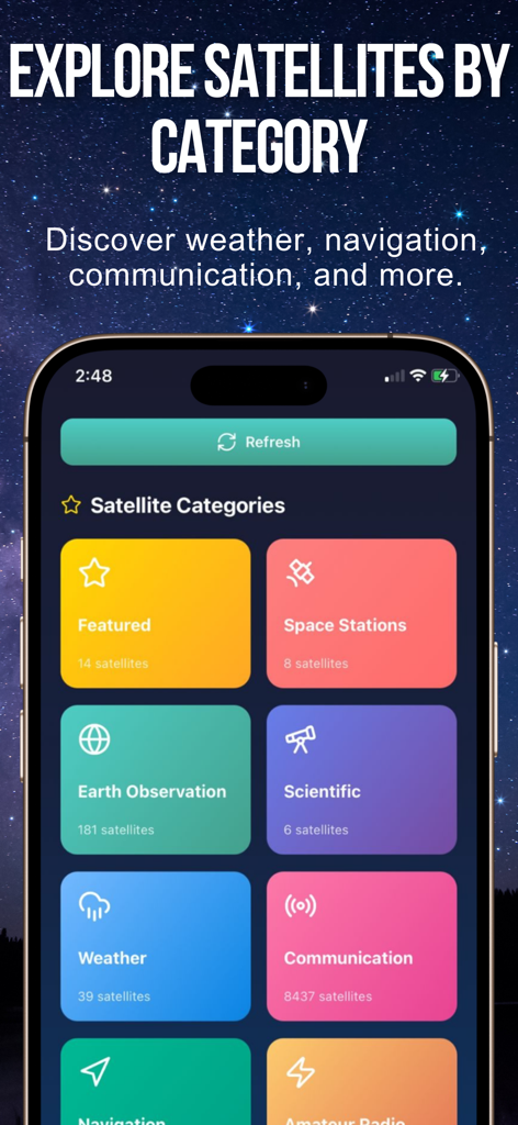
위성 추적기 앱 인터페이스가 별이 빛나는 하늘 배경 위에 우주 정거장 및 날씨와 같은 범주별 위성 그룹을 보여줍니다.
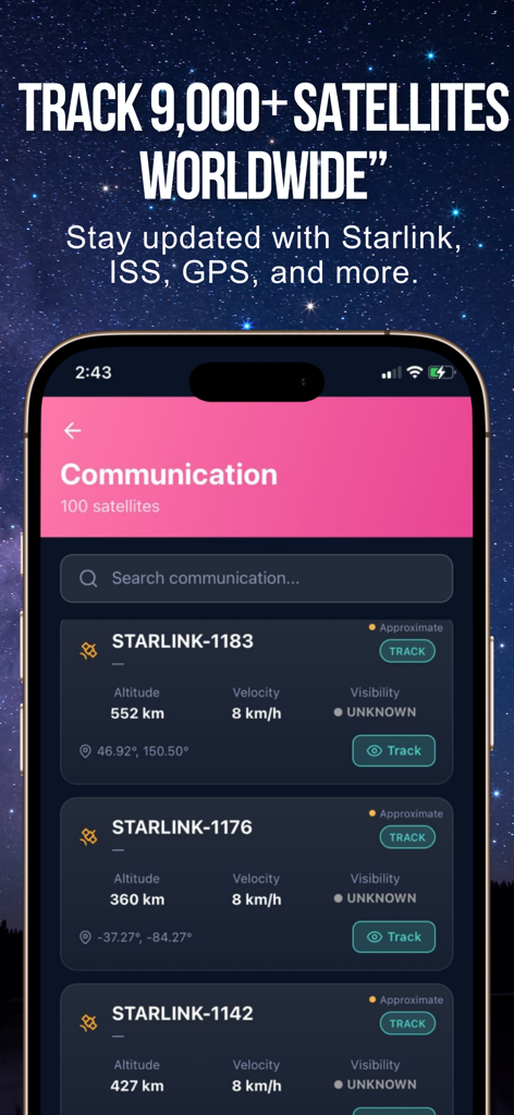
위성 추적기 앱 인터페이스가 고도 및 속도 데이터와 함께 추적된 Starlink 위성 목록을 보여줍니다.
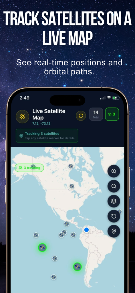
세계 지도 위에 실시간 궤도 위치 및 경로를 보여주는 라이브 위성 지도
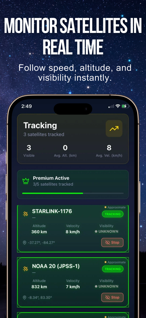
Starlink 및 NOAA 위성의 고도 및 속도를 보여주는 실시간 위성 추적 대시보드
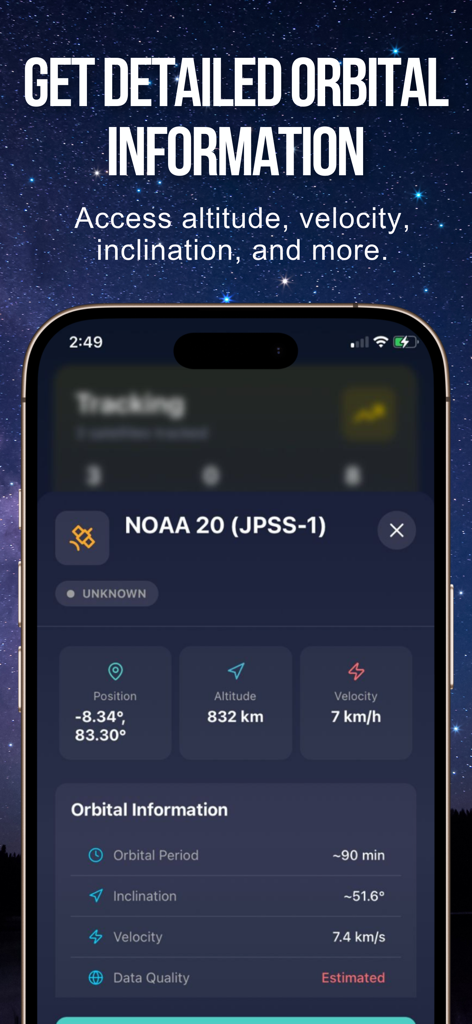
고도 및 속도를 포함한 NOAA 20 위성의 자세한 궤도 정보를 보여주는 모바일 화면
설명
Download
비슷한 앱
같은 카테고리의 상위 앱

Google Translate
Google LLC

火箭沙盒
P2E CO., LTD.

Bible
Life.Church

Bible Chat: Daily Devotional
BookVitals APP SRL

Youdao Dictionary
Beijing NetEase Youdao Computer System Co.,Ltd

Translate Now - AI Translator
AIR APPS SYSTEMS, UNIPESSOAL, LDA

Naver Papago - AI Translator
NAVER Corp.

ΗiΤV - Endless Movies & Shows
学 张

Live Translator - AI Translate
DigitalSail (HK) Limited
이 페이지는 앱이나 개발자의 공식 페이지가 아니며, 정보 제공 및 논평을 목적으로 작성된 독립 편집 간행물입니다. 명시적으로 달리 언급되지 않는 한, 해당 앱이나 개발자는 MWM, Apple, Google Play, 앱 퍼블리셔 또는 앱 개발자와 제휴, 보증, 후원, 승인 또는 공식적으로 연결되어 있지 않으며, 이 페이지의 어떤 내용도 해당 앱이 MWM의 서비스를 사용하여 개발되었음을 의미하지 않습니다. 모든 상표, 로고, 스크린샷 및 기타 콘텐츠는 해당 소유자의 자산입니다.