이 페이지는 앱이나 개발자의 공식 페이지가 아니며, 정보 제공 및 논평을 목적으로 작성된 독립 편집 간행물입니다. 명시적으로 달리 언급되지 않는 한, 해당 앱이나 개발자는 MWM, Apple, Google Play, 앱 퍼블리셔 또는 앱 개발자와 제휴, 보증, 후원, 승인 또는 공식적으로 연결되어 있지 않으며, 이 페이지의 어떤 내용도 해당 앱이 MWM의 서비스를 사용하여 개발되었음을 의미하지 않습니다. 모든 상표, 로고, 스크린샷 및 기타 콘텐츠는 해당 소유자의 자산입니다.

SeaLegs AI
추측은 그만하고 전문적인 수준의 해상 날씨와 함께 순항을 시작하세요. 저희 AI는 수천 개의 데이터 포인트를 분석하여 특정 선박에 맞춤화된 명확한 이동, 주의 또는 회피 권장 사항을 제공합니다.
다운로드
900사용자 평점
총 평가 수
0개발사
카테고리
Weather지원 언어
6최신 버전
1.0.54크기
13.1 MB출시일
2025년 9월 6일당신의 개인 AI 부함장
복잡한 기상학은 저희에게 맡기세요. SeaLegs AI는 수천 개의 데이터 포인트를 분석하여 모든 여행이 안전하고 원활하며 특정 선박에 완벽하게 맞춰지도록 보장합니다.
즉각적인 이동/비이동 명확성
구체적인 보트 성능과 승무원의 안전에 맞춰진 명확한 AI 기반 권장 사항으로 데이터 피로를 건너뛰세요.
엘리트 다중 모델 정밀도
ECMWF, GFS 및 ICON과 같은 세계에서 가장 신뢰할 수 있는 날씨 모델을 집계하여 전문적인 수준의 정확성에 접근하세요.
다음 스크린샷과 설명은 앱의 공식 스토어 목록에서 직접 가져온 것이며 앱 개발자의 자산입니다.
앱 스토어
스크린샷

AI 여행 분석과 바람 및 파도 안전 권장 사항을 보여주는 해상 날씨 예보 인터페이스
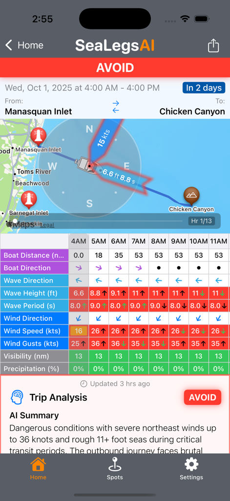
상세한 해상 날씨 데이터 및 AI 분석과 함께 회피 여행 권장 사항을 보여주는 SeaLegs AI 앱 인터페이스
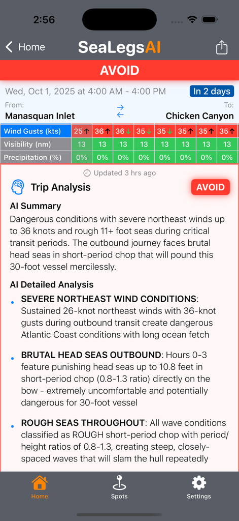
Manasquan Inlet와 Chicken Canyon 사이의 위험한 바다 조건에 대한 회피 권장 사항을 표시하는 SeaLegs AI 앱 여행 분석 화면
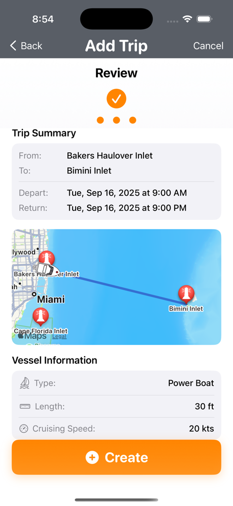
선박 사양 및 경로 지도가 포함된 Bakers Haulover Inlet에서 Bimini Inlet까지의 해상 여행 검토를 보여주는 SeaLegs AI 앱 화면.
설명
Download
비슷한 앱
같은 카테고리의 상위 앱

墨迹天气-MojiWeather
Beijing MojiFengyun Technology Co.,Ltd.

The Weather Channel - Radar
The Weather Channel

Windy.com
Windyty, SE

天气预报-精准15日天气预报
Chongqing Caochen Technology Co., Ltd.

My Aurora Forecast & Alerts
JRustonApps B.V.

AccuWeather: Weather Forecast
AccuWeather International, Inc.

Weather & Radar - Storm radar
WetterOnline - Meteorologische Dienstleistungen GmbH

天气通
Weibo Internet Technology (China) Co.Ltd.

The Thermometer -Digital-
Vida Apps Incorporated
이 페이지는 앱이나 개발자의 공식 페이지가 아니며, 정보 제공 및 논평을 목적으로 작성된 독립 편집 간행물입니다. 명시적으로 달리 언급되지 않는 한, 해당 앱이나 개발자는 MWM, Apple, Google Play, 앱 퍼블리셔 또는 앱 개발자와 제휴, 보증, 후원, 승인 또는 공식적으로 연결되어 있지 않으며, 이 페이지의 어떤 내용도 해당 앱이 MWM의 서비스를 사용하여 개발되었음을 의미하지 않습니다. 모든 상표, 로고, 스크린샷 및 기타 콘텐츠는 해당 소유자의 자산입니다.