이 페이지는 앱이나 개발자의 공식 페이지가 아니며, 정보 제공 및 논평을 목적으로 작성된 독립 편집 간행물입니다. 명시적으로 달리 언급되지 않는 한, 해당 앱이나 개발자는 MWM, Apple, Google Play, 앱 퍼블리셔 또는 앱 개발자와 제휴, 보증, 후원, 승인 또는 공식적으로 연결되어 있지 않으며, 이 페이지의 어떤 내용도 해당 앱이 MWM의 서비스를 사용하여 개발되었음을 의미하지 않습니다. 모든 상표, 로고, 스크린샷 및 기타 콘텐츠는 해당 소유자의 자산입니다.
Tractor GPS Field Guidance PRO
전문가급 내비게이션으로 수확량을 극대화하고 투입 비용을 절감하세요. 중복을 없애고, 정밀하게 줄을 추적하며, iPhone 또는 iPad를 스마트 농업 대시보드로 전환하세요. 비싼 하드웨어는 필요 없습니다.
주요 수치
다운로드
3K+
사용자 평점
4.5/5
총 평가 수
100
개발사
启伟 廖
카테고리
Navigation
지원 언어
12
최신 버전
1.1.7
크기
85.8 MB
출시일
2025년 6월 4일
기능
정밀 필드 가이드로 모든 에이커를 극대화하세요
iPad 또는 iPhone을 전문가급 트랙터 GPS 시스템으로 전환하여 중복을 없애고, 낭비를 줄이며, 농장의 ROI를 높이세요.
줄 중복 제거
완벽하게 직선을 유지하고 일관된 간격을 두어 파종 또는 살포 시 놓치는 부분 없이 연료 낭비 없이 작업하세요.
투입 비용 대폭 절감
커버리지를 정밀하게 추적하고 비용이 많이 드는 이중 적용을 피하여 사용하는 씨앗, 비료, 화학 물질의 양을 줄이세요.
다음 스크린샷과 설명은 앱의 공식 스토어 목록에서 직접 가져온 것이며 앱 개발자의 자산입니다.
앱 스토어
스크린샷
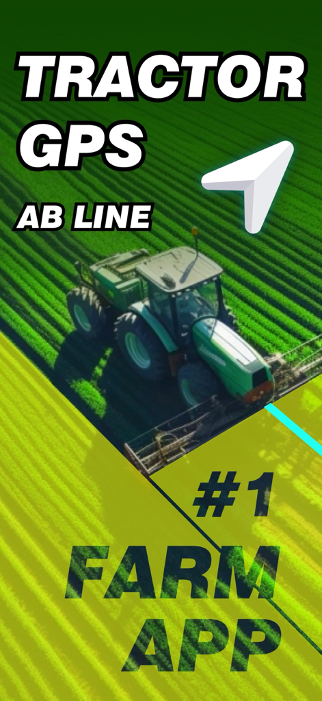
트랙터 GPS 내비게이션 앱이 정밀 농업을 위한 AB 라인 안내를 보여줍니다
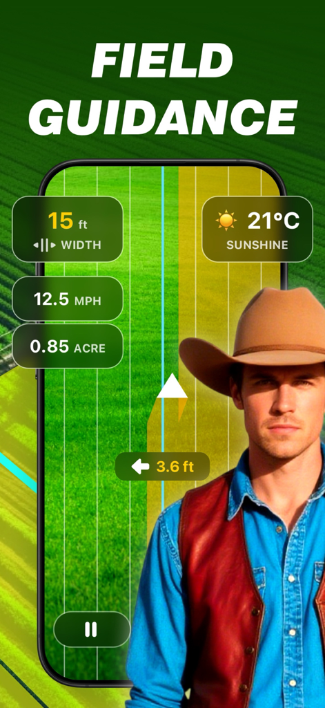
앞쪽에 농부가 있는 GPS 매핑 데이터와 트랙터 필드 안내 앱을 보여주는 스마트폰 화면
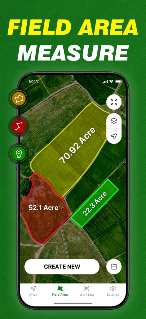
위성 지도에 에이커 단위의 농경지 면적 측정을 표시하는 모바일 앱 인터페이스.
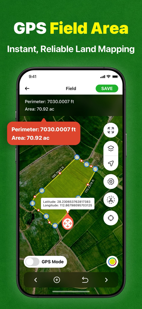
스마트폰의 GPS 필드 면적 측정 및 토지 매핑 인터페이스
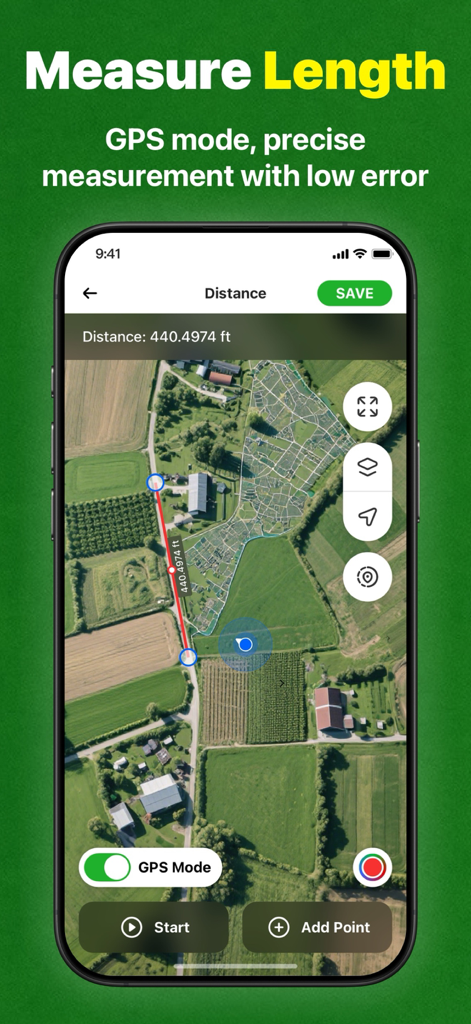
농경지 위성 지도에서 길이 측정 기능을 보여주는 트랙터 GPS 필드 가이드 PRO 앱 스크린샷.
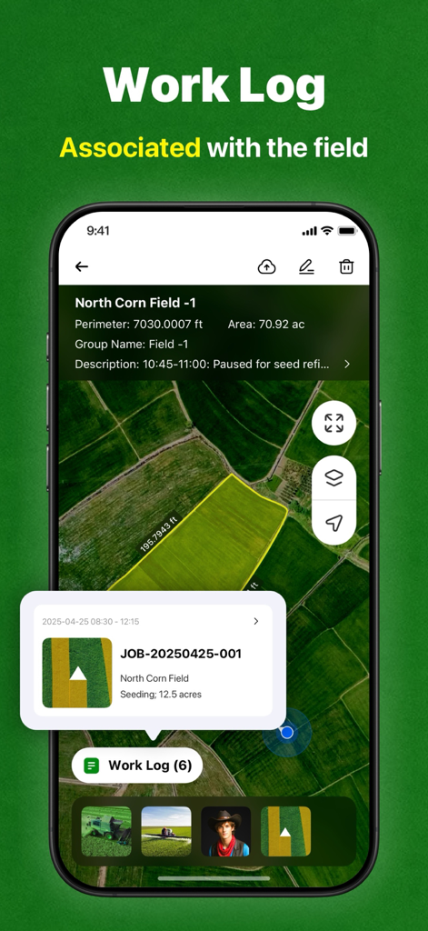
면적 측정 및 파종 활동 기록이 있는 옥수수 밭 지도를 보여주는 트랙터 GPS 앱의 작업 로그 화면.
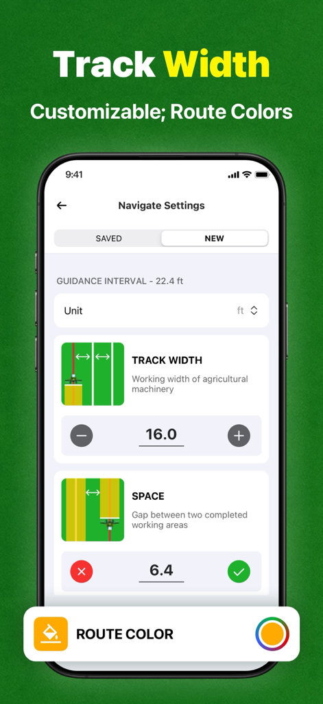
트랙터 안내를 위한 트랙 너비 및 간격 구성을 보여주는 내비게이션 설정 화면.
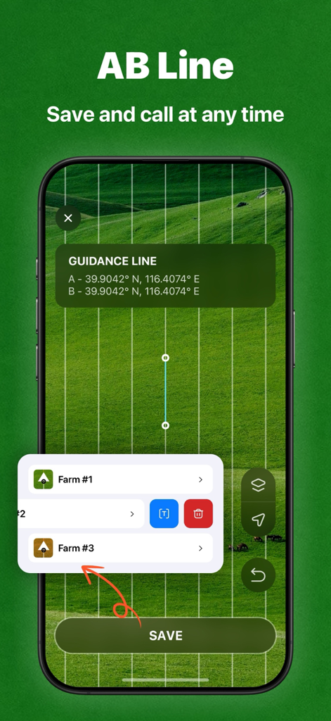
저장된 농장 위치 목록과 함께 직선 줄 농업을 위한 AB 라인 안내를 보여주는 트랙터 GPS 앱 인터페이스.
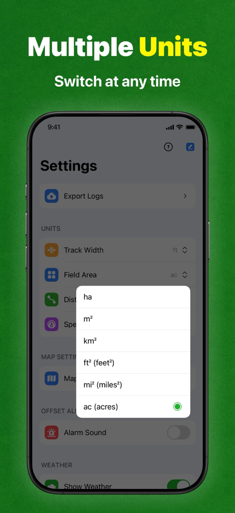
밭 면적 측정을 위한 헥타르, 제곱피트, 에이커와 같은 면적 단위 목록을 보여주는 트랙터 GPS 앱의 설정 화면.
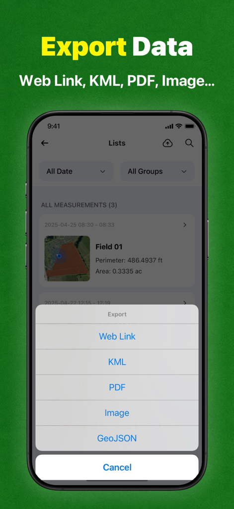
KML PDF 및 GeoJSON 형식을 포함한 필드 데이터 측정 내보내기 옵션을 보여주는 트랙터 GPS 앱 인터페이스.
설명
Tractor GPS Navigation is designed for tractor and agricultural machinery operators, providing precise navigation and intelligent operation management, covering the entire agricultural process such as planting, fertilization, spraying, harvesting, etc., to help you improve operation efficiency and reduce production costs.
**Applicable scenarios:
• Straight-line seeding navigation of field crops
• Automatic profiling operation in orchards
• Terraced contour farming
• Variable fertilization and pesticide application operation
• Agricultural machinery operation area calculation
**GPS Field Area Measurement:
Use GPS to easily measure the area of any piece of land, including farms, fields, houses, yards, mountains, reservoirs, and construction sites, by selecting points on Google Maps. This highly accurate measurement is available.
Why choose this APP?
** Economical and affordable **
Compared with expensive dedicated GPS devices, this smartphone-based navigation APP is cheaper and can be used by just downloading, greatly reducing the technical threshold of precision agriculture.
** Precision operation **
Using high-precision GPS technology, automatically generate and track field operation routes to ensure consistent row spacing, reduce overlaps and omissions, and save time and fuel.
**Smart Recording**
Seamlessly connect to mainstream agricultural machinery and equipment, automatically record operation data and store it safely, which is convenient for retrospective analysis and optimized management.
- Area Calculator:
Easily convert measured land areas to acres, hectares, square meters, and other units, allowing you to easily grasp land area.
- Distance Measurement:
Quickly calculate the distance between multiple points on a map, perfect for measuring roads, bridges, parks, or planning routes with real-time tracking and accuracy.
- Mapping:
Draw shapes or mark custom boundaries directly on Google Maps to visually outline parcels, areas, or routes. Perfect for planning, mapping, or real estate visualization.
- Perimeter Measurement:
Accurately calculate the total boundary length of any selected area or parcel of land, helping you estimate land, roads, pipelines, or irrigation needs with just a few taps.
**Reduce costs**
Precisely control the application amount of seeds, fertilizers, and pesticides to avoid waste, reduce input costs, and reduce environmental impact.
**Increase production and efficiency**
Based on precise mapping and data analysis, optimize planting layout and resource allocation, improve crop health, and promote yield growth.
**Reduce fatigue**
Automatic navigation reduces manual steering operations, reduces operation intensity, allows operators to focus more on machine monitoring, and extends efficient operation time.
Start efficient farming now!
Download "Tractor GPS Navigation" to start a new era of smart agriculture. Precision farming, increase production and income, and make every inch of land more valuable!
If you subscribe through Apple, your App Store account will be charged at confirmation of purchase.
- Payment will be charged to your iTunes account at confirmation of purchase.
- Subscription automatically renews unless auto-renew is turned off at least 24 hours before the end of the current period.
- Account will be charged for renewal 24 hours prior to the end of the current period, and identify the cost of the renewal.
- Subscriptions may be managed by the user and auto-renewal may be turned off by going to the user's Account Settings after purchase
Standard Apple Terms of Use (EULA):
https://www.apple.com/legal/internet-services/itunes/dev/stdeula/
Privacy Policy:
http://senxunstudio.com/tractorgps/TractorGPS_Privacy.html
이 페이지는 앱이나 개발자의 공식 페이지가 아니며, 정보 제공 및 논평을 목적으로 작성된 독립 편집 간행물입니다. 명시적으로 달리 언급되지 않는 한, 해당 앱이나 개발자는 MWM, Apple, Google Play, 앱 퍼블리셔 또는 앱 개발자와 제휴, 보증, 후원, 승인 또는 공식적으로 연결되어 있지 않으며, 이 페이지의 어떤 내용도 해당 앱이 MWM의 서비스를 사용하여 개발되었음을 의미하지 않습니다. 모든 상표, 로고, 스크린샷 및 기타 콘텐츠는 해당 소유자의 자산입니다.