이 페이지는 앱이나 개발자의 공식 페이지가 아니며, 정보 제공 및 논평을 목적으로 작성된 독립 편집 간행물입니다. 명시적으로 달리 언급되지 않는 한, 해당 앱이나 개발자는 MWM, Apple, Google Play, 앱 퍼블리셔 또는 앱 개발자와 제휴, 보증, 후원, 승인 또는 공식적으로 연결되어 있지 않으며, 이 페이지의 어떤 내용도 해당 앱이 MWM의 서비스를 사용하여 개발되었음을 의미하지 않습니다. 모든 상표, 로고, 스크린샷 및 기타 콘텐츠는 해당 소유자의 자산입니다.

TrailWatch: Your Hiking Guide
최첨단 GPS 추적, 실시간 그룹 안전 기능, 시민 보고를 사용하여 우리의 트레일 아름다움을 보존하는 환경 의식 탐험가 커뮤니티에 참여하세요.
다운로드
98K+사용자 평점
총 평가 수
3K+개발사
카테고리
Travel지원 언어
1최신 버전
3.9.2크기
32.8 MB출시일
2014년 1월 29일더 높은 목적을 가지고 자연을 경험하세요
최첨단 GPS 추적과 환경 관리를 결합하세요. TrailWatch는 여러분이 사랑하는 트레일을 탐색하고, 공유하고, 보호할 수 있도록 지원합니다.
시민 주도 보존
실시간으로 트레일 손상 또는 특이 사건을 보고하여 중요한 컨트리 파크 환경을 보존하고 보호하는 데 도움을 주세요.
스마트 그룹 안전
모든 탐험에 대한 실시간 GPS 위치 추적 및 자동 사진 공유로 하이킹 그룹을 연결하세요.
다음 스크린샷과 설명은 앱의 공식 스토어 목록에서 직접 가져온 것이며 앱 개발자의 자산입니다.
앱 스토어
스크린샷
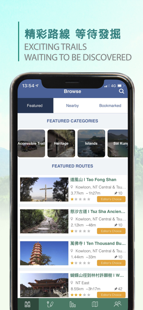
홍콩의 주요 하이킹 경로 및 카테고리를 보여주는 TrailWatch 앱 인터페이스
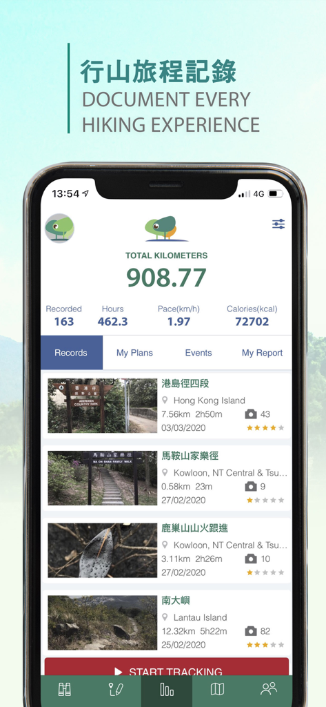
총 하이킹 킬로미터 칼로리를 표시하고 기록된 트레일 목록이 있는 TrailWatch 앱 인터페이스
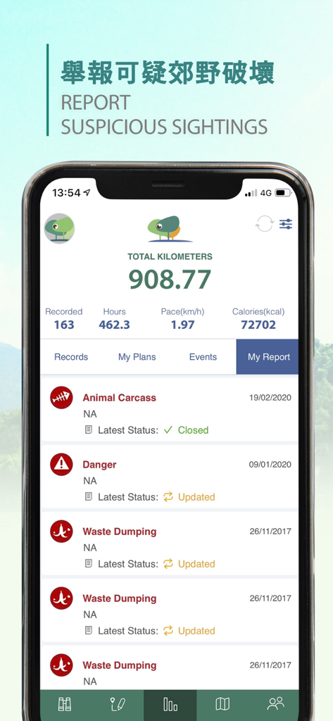
사용자 하이킹 통계와 폐기물 투기 및 위험과 같은 보고된 환경 사건 목록을 표시하는 TrailWatch 앱 인터페이스
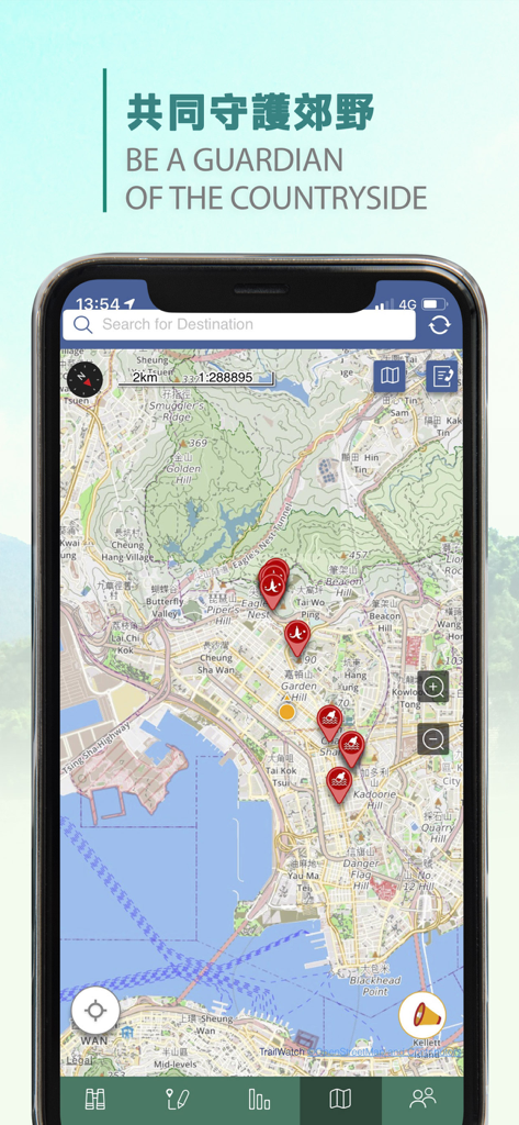
홍콩의 하이킹 트레일에 사건을 나타내는 빨간색 마커가 있는 TrailWatch 앱 지도를 보여주는 스마트폰 화면
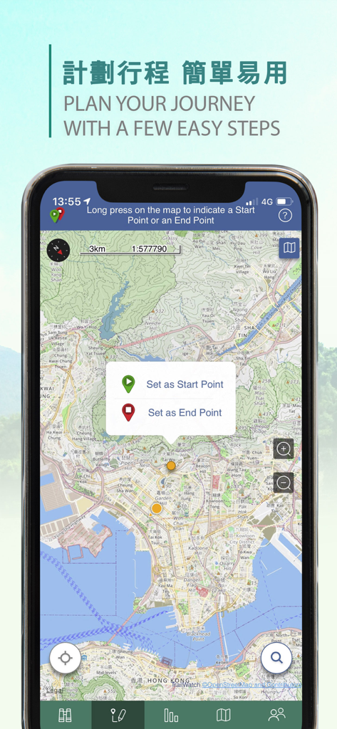
시작점과 끝점을 설정하여 하이킹 여정을 계획하기 위한 지도 인터페이스를 보여주는 TrailWatch 모바일 앱.
설명
Download
비슷한 앱
같은 카테고리의 상위 앱

Uber - Request a ride
Uber Technologies, Inc.

Airbnb
Airbnb, Inc.

铁路12306
ACADEMY OF RAILWAY SCIENCES CO., ltd.

Booking.com: Hotels & Travel
Booking.com B.V.

Grab: Taxi Ride, Food Delivery
GRABTAXI HOLDINGS PTE. LTD.

Trip.com: Book Flights, Hotels
Trip.com Travel Singapore Pte. Ltd.

DiDi China: Ride Hailing
Didi Chuxing (Beijing) Network Platform Technology Co., Ltd

去哪儿旅行-订酒店机票火车票
Beijing Qunar Information Technology Company Limit

Bolt: Request a Ride
BOLT TECHNOLOGY OU
이 페이지는 앱이나 개발자의 공식 페이지가 아니며, 정보 제공 및 논평을 목적으로 작성된 독립 편집 간행물입니다. 명시적으로 달리 언급되지 않는 한, 해당 앱이나 개발자는 MWM, Apple, Google Play, 앱 퍼블리셔 또는 앱 개발자와 제휴, 보증, 후원, 승인 또는 공식적으로 연결되어 있지 않으며, 이 페이지의 어떤 내용도 해당 앱이 MWM의 서비스를 사용하여 개발되었음을 의미하지 않습니다. 모든 상표, 로고, 스크린샷 및 기타 콘텐츠는 해당 소유자의 자산입니다.