이 페이지는 앱이나 개발자의 공식 페이지가 아니며, 정보 제공 및 논평을 목적으로 작성된 독립 편집 간행물입니다. 명시적으로 달리 언급되지 않는 한, 해당 앱이나 개발자는 MWM, Apple, Google Play, 앱 퍼블리셔 또는 앱 개발자와 제휴, 보증, 후원, 승인 또는 공식적으로 연결되어 있지 않으며, 이 페이지의 어떤 내용도 해당 앱이 MWM의 서비스를 사용하여 개발되었음을 의미하지 않습니다. 모든 상표, 로고, 스크린샷 및 기타 콘텐츠는 해당 소유자의 자산입니다.

다운로드
25M+사용자 평점
총 평가 수
1.4M개발사
카테고리
Navigation지원 언어
8최신 버전
6.1.4크기
477.8 MB출시일
2012년 6월 22일Transit • Subway & Bus Times 앱 분석
도시 이동성을 향상시키는 핵심 기능
최고의 실시간 데이터
이 앱은 버스, 지하철 등 모든 대중교통 수단에 대한 가장 정확한 실시간 도착 정보와 차량 위치를 제공하여 사용자가 정확한 이동 계획을 세울 수 있도록 돕습니다.
뛰어난 경로 계획
이 도구는 가장 빠른 대중교통 경로를 계획하고, 자전거+기차, 버스+지하철 등 다양한 이동 수단 조합을 비교하여 사용자가 최적의 이동 방법을 찾을 수 있게 합니다.
GO 내비게이션 및 실시간 기여
이 기능은 출발 알람을 설정하고 하차 및 환승 시기를 알려주어 사용자의 편리한 이동을 돕습니다. 또한, 다른 사용자에게 정확한 실시간 정보를 제공하는 데 기여할 수 있게 합니다.
즉각적인 교통 알림
이 앱은 대중교통 지연 및 운행 중단에 대한 즉각적인 알림을 제공하여 사용자가 이동 계획을 신속하게 조정하고 불필요한 기다림을 피할 수 있도록 돕습니다.
즐겨찾기 저장 및 빠른 계획
사용자가 자주 방문하는 목적지와 이용하는 대중교통 노선을 저장하여 단 한 번의 탭으로 간편하게 여행을 계획하고 시간을 절약할 수 있도록 해줍니다.
오프라인 지원
이 앱은 인터넷 연결이 불안정한 지하철 구간이나 신호가 약한 지역에서도 버스 시간표, 정류장 위치, 지하철 지도 및 경로 계획 기능을 오프라인으로 사용할 수 있도록 지원합니다.
크라우드소싱 정보 활용
이 도구는 수백만 명의 사용자로부터 수집된 데이터를 통해 대중교통의 혼잡도, 정시 운행 여부, 최적의 역 출구 등 실질적이고 유용한 정보를 제공합니다.
간편한 결제
이 앱은 100개 이상의 도시에서 대중교통 요금을 지불하고 자전거 공유 패스를 앱 내에서 직접 구매할 수 있는 편리한 결제 기능을 갖추고 있습니다.
자주 묻는 질문
에 대해 알아야 할 모든 것 Transit • Subway & Bus Times
What is the Transit app?
The Transit app helps users navigate public transportation in over 1,000 cities. It provides live departure times, real-time vehicle tracking, and trip planning for various modes like bus, subway, and rideshare.
How does the Transit app provide real-time public transit information?
The Transit app uses the best transit agency data, GO crowdsourcing data, and its in-house ETA prediction engine to provide accurate real-time information for all transport modes.
Can I plan multi-modal trips using the Transit app?
Yes, the Transit app allows users to plan trips combining multiple modes, such as bus + bike or scooter + metro, to find the fastest and easiest routes.
Does the Transit app offer offline features?
Yes, the Transit app provides offline support for bus schedules, stop locations, subway maps, and its trip planner, ensuring functionality even when GPS is spotty.
Can I get alerts about transit delays with the Transit app?
Yes, the Transit app provides instant alerts about delays and disruptions, keeping users informed about changes to their public transportation routes.
How can Transit app users contribute to real-time data?
Users can contribute more accurate real-time information for other passengers through the GO navigation feature, and by rating their ride and providing feedback on crowding levels.
Does the Transit app support payments for fares?
Yes, the Transit app supports easy payments, allowing users to pay transit fares and buy bikeshare passes directly within the app in over 100 cities.
What types of navigation does the Transit app provide?
The Transit app provides step-by-step navigation for public transit trips, including alerts for departures and stops, and offers detailed bike directions.
In which cities can I use the Transit app for public transportation?
The Transit app supports public transportation in over 1,000 cities worldwide, including major locations like New York City, London, Paris, and Chicago.
How does the Transit app help users find nearby departures?
The Transit app instantly displays all nearby departures on a map, showing real-time estimated arrival times for various bus and subway lines.
다음 스크린샷과 설명은 앱의 공식 스토어 목록에서 직접 가져온 것이며 앱 개발자의 자산입니다.
앱 스토어
스크린샷
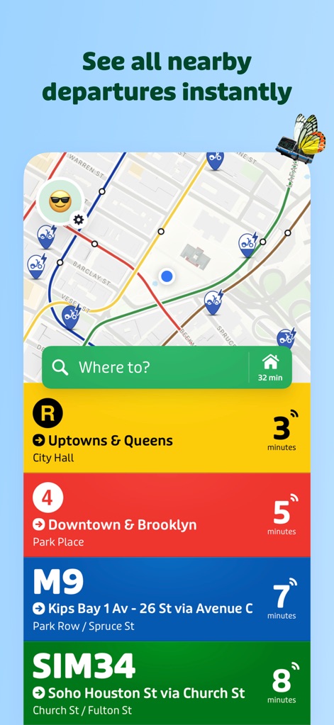
즉시 출발 확인
이 화면은 사용자가 현재 위치 주변의 모든 대중교통 출발 정보를 실시간으로 파악할 수 있도록 지도 인터페이스와 함께 노선별 예상 도착 시간을 명확하게 보여줍니다.
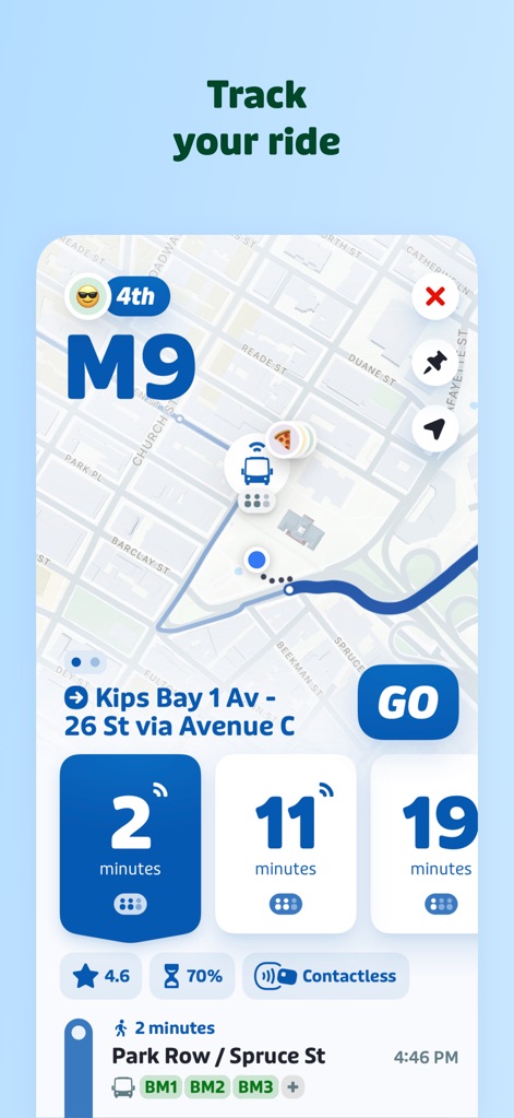
실시간 차량 추적
사용자는 이 화면에서 대중교통 차량의 실시간 이동 경로를 지도상에서 시각적으로 확인할 수 있으며, 버스나 지하철의 남은 도착 시간과 GO 버튼을 통해 능동적인 탑승 지원을 받을 수 있습니다.
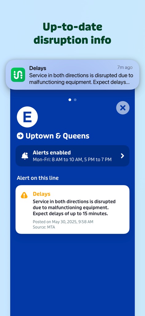
최신 지연 정보
이 앱은 서비스 지연에 대한 즉각적인 알림 메시지를 제공하여, 사용자가 상세한 지연 원인과 예상 지연 시간을 파악하고 대안을 모색할 수 있도록 돕습니다.
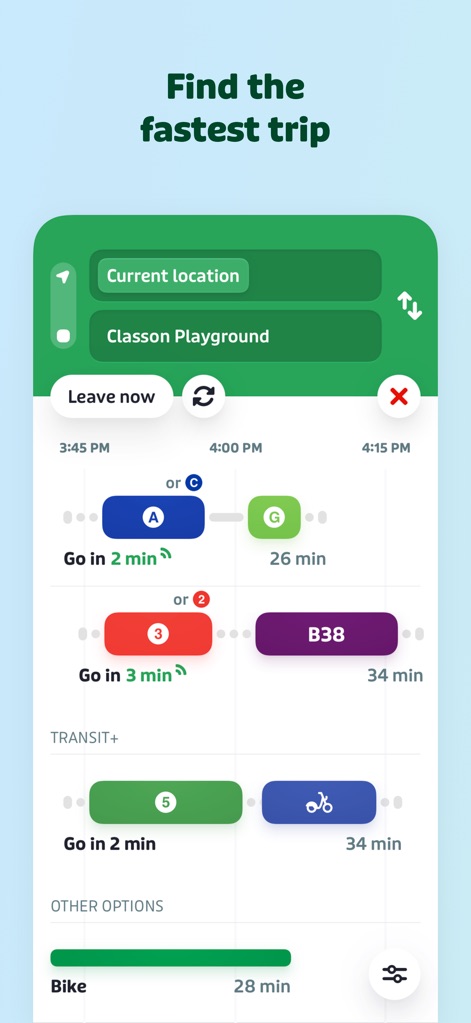
최적 경로 탐색
사용자는 이 화면을 통해 출발지와 목적지를 설정하여 다양한 대중교통 조합을 포함한 최단 시간 경로를 비교하고, 자전거 옵션과 같은 대체 이동 수단도 함께 고려할 수 있습니다.
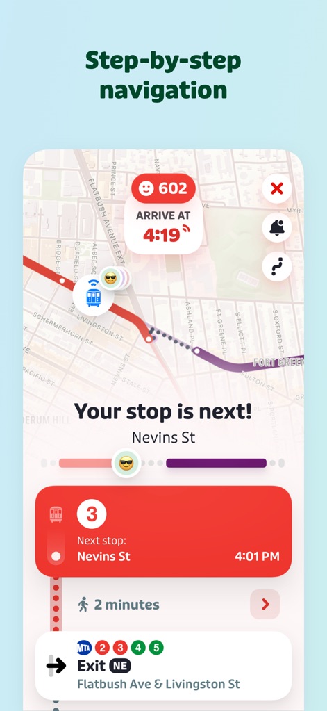
단계별 경로 안내
이 앱은 실시간 위치 기반으로 다음 정류장 알림과 함께 상세한 경로 안내를 제공하며, 사용자가 특정 출구 정보를 확인하여 목적지까지 헤매지 않고 도착하도록 돕습니다.
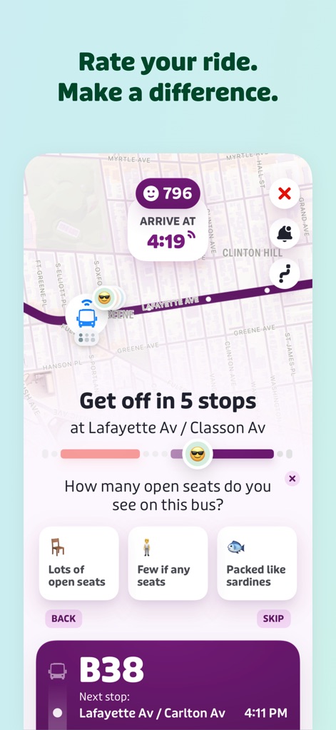
탑승 경험 공유
사용자는 이 화면에서 현재 탑승 중인 차량의 좌석 여유도를 직접 입력하여 다른 이용자들에게 유용한 정보를 제공할 수 있으며, 다음 정류장 정보도 동시에 확인할 수 있습니다.
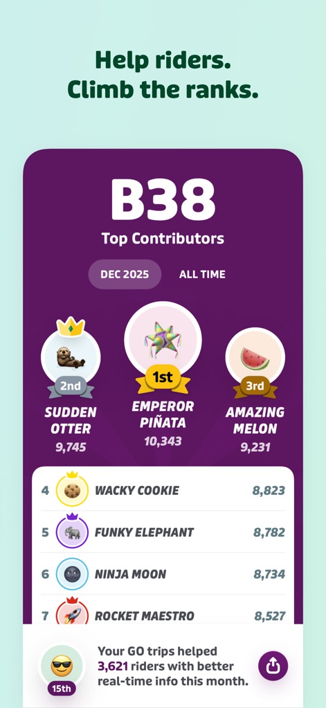
커뮤니티 기여 순위
이 앱은 상위 기여자 리더보드를 통해 커뮤니티 활동을 장려하며, 사용자가 실시간 정보 제공에 기여한 수치를 명확히 보여줌으로써 적극적인 참여를 유도합니다.
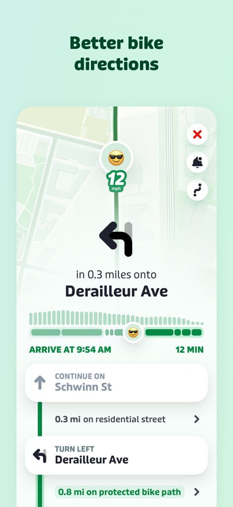
상세 자전거 경로
사용자는 이 화면에서 자전거 이용자를 위한 단계별 주행 안내를 받을 수 있으며, 보호된 자전거 도로와 같은 특정 도로 유형에 대한 정보도 확인할 수 있습니다.
설명
Download
비슷한 앱
유사한 기능과 사용자 경험을 가진 앱

MTA TrainTime
MTA/New York City Transit

NJ TRANSIT Mobile App
NJ TRANSIT

쏘카 - 라이프타임 모빌리티 플랫폼
SOCAR Inc.

ONAY! - Ваш городской помощник
ONAI PAY, TOO

Chennai One
Chennai Unified Metropolitan Transport Authority

哈啰-骑车顺风车打车租车
Shanghai Haluo Pratt&Whitney Technology Co., Ltd

Île-de-France Mobilités
Ile de France Mobilites

MARTI: TAG & Scooter
MARTI TEKNOLOJI LIMITED SIRKETI

Freenow by Lyft - taxi & more
Intelligent Apps GmbH
이 페이지는 앱이나 개발자의 공식 페이지가 아니며, 정보 제공 및 논평을 목적으로 작성된 독립 편집 간행물입니다. 명시적으로 달리 언급되지 않는 한, 해당 앱이나 개발자는 MWM, Apple, Google Play, 앱 퍼블리셔 또는 앱 개발자와 제휴, 보증, 후원, 승인 또는 공식적으로 연결되어 있지 않으며, 이 페이지의 어떤 내용도 해당 앱이 MWM의 서비스를 사용하여 개발되었음을 의미하지 않습니다. 모든 상표, 로고, 스크린샷 및 기타 콘텐츠는 해당 소유자의 자산입니다.