이 페이지는 앱이나 개발자의 공식 페이지가 아니며, 정보 제공 및 논평을 목적으로 작성된 독립 편집 간행물입니다. 명시적으로 달리 언급되지 않는 한, 해당 앱이나 개발자는 MWM, Apple, Google Play, 앱 퍼블리셔 또는 앱 개발자와 제휴, 보증, 후원, 승인 또는 공식적으로 연결되어 있지 않으며, 이 페이지의 어떤 내용도 해당 앱이 MWM의 서비스를 사용하여 개발되었음을 의미하지 않습니다. 모든 상표, 로고, 스크린샷 및 기타 콘텐츠는 해당 소유자의 자산입니다.

Yandex Maps & Navigator
도시는 혼돈이다. 이 앱은 그 혼돈 속에서 정확한 지배력을 부여하며, 사용자의 모든 움직임을 미리 파악하게 한다.
다운로드
25M+사용자 평점
총 평가 수
2.0M개발사
카테고리
Navigation지원 언어
11최신 버전
28.4.3크기
719.8 MB출시일
2009년 5월 13일Yandex Maps & Navigator 앱 분석
효율적인 이동 및 지역 정보 탐색을 위한 주요 기능 평가
다중 모드 내비게이션 및 실시간 안내
이 도구는 운전, 대중교통, 자전거, 도보 등 다양한 이동 수단에 대한 최적 경로를 제공하며, 실시간 교통 상황, 음성 안내, 속도 제한 알림, 도로 사고 업데이트 등의 정보를 통해 사용자의 이동을 지원합니다.
실시간 교통 정보
사용자는 현재 도시의 교통 상황을 보여주는 도로 지도를 통해 혼잡한 구간을 피하고 최적의 경로를 선택할 수 있습니다.
종합적인 지역 정보
이 앱은 방대한 기관 데이터베이스와 상세한 정보를 제공하여 사용자가 연락처, 영업시간, 서비스, 사진, 리뷰 등을 통해 주변 장소를 효과적으로 탐색할 수 있도록 돕습니다.
실시간 대중교통 추적
이 도구는 버스, 트램, 트롤리버스, 미니버스의 실시간 위치를 표시하여 사용자가 대중교통 이용 계획을 효율적으로 세울 수 있도록 지원합니다.
강력한 오프라인 기능
사용자는 인터넷 연결 없이도 운전 경로 및 음성 내비게이션, 기관 데이터베이스 접근 등 다양한 기능을 이용할 수 있으며, 가벼운 용량의 지도를 다운로드하여 효율적으로 저장 공간을 활용할 수 있습니다.
주차 정보
이 앱은 공식 주차장의 위치와 비용을 표시하는 주차 레이어를 제공하여 사용자가 편리하게 주차 공간을 찾을 수 있게 합니다.
거리 파노라마 보기
사용자는 거리 파노라마 기능을 통해 어떤 주소라도 길가의 실제 모습을 미리 확인할 수 있어 목적지 파악에 도움이 됩니다.
사용자 참여 및 커뮤니티 기능
이 앱은 사용자가 지도에 도로 이벤트를 표시하고, 다른 사용자의 제출물에 의견을 남기며, 기관에 대한 리뷰를 작성하고 정보를 업데이트하는 등 활발한 커뮤니티 참여를 가능하게 합니다.
자주 묻는 질문
에 대해 알아야 할 모든 것 Yandex Maps & Navigator
Can Yandex Maps & Navigator help with indoor navigation in various locations?
Yes, Yandex Maps & Navigator enables planning indoor routes for train stations, airports, and shopping malls, providing assistance within complex buildings.
Does Yandex Maps & Navigator show real-time public transport arrival times?
Yes, Yandex Maps & Navigator displays real-time public transport arrival times and locations for buses, trams, and minibuses, helping users plan trips.
Does Yandex Maps & Navigator provide detailed road markings for drivers?
Yes, Yandex Maps & Navigator provides highly detailed road markings and lane guidance to assist drivers, enhancing navigation ease and safety.
Does Yandex Maps & Navigator offer traffic jam forecasts and speed limit alerts?
Yes, Yandex Maps & Navigator provides traffic jam forecasts, real-time traffic updates, and notifications for speed cameras and speed limits, optimizing driving.
Can I use Yandex Maps & Navigator for offline navigation?
Yes, Yandex Maps & Navigator allows users to download lightweight offline maps, enabling driving routes, voice navigation, and searches without an internet connection.
What transport modes does Yandex Maps & Navigator support for routes?
Yandex Maps & Navigator supports route planning for cars, public transport, metro, taxi, bikes, scooters, and walking, providing comprehensive travel options.
Can Yandex Maps & Navigator help find places of interest and reviews?
Yes, Yandex Maps & Navigator enables searching for places like cafes, providing detailed information including ratings, photos, reviews, and hours of operation.
Does Yandex Maps & Navigator support Apple CarPlay integration?
Yes, Yandex Maps & Navigator supports Apple CarPlay, allowing users to project navigation and map information directly onto their car's display screen.
Is Yandex Maps & Navigator available on Apple Watch?
Yes, Yandex Maps & Navigator has a dedicated Apple Watch app. It facilitates navigation, viewing nearby public transport, checking arrival times, and tracking traffic.
Does Yandex Maps & Navigator provide information on parking?
Yes, Yandex Maps & Navigator includes a parking layer that displays the location and cost of official parking spots within the city.
Where can I find the Privacy Policy for Yandex Maps & Navigator?
The Privacy Policy for Yandex Maps & Navigator is accessible at the official URL: yandex.com/legal/confidential.
다음 스크린샷과 설명은 앱의 공식 스토어 목록에서 직접 가져온 것이며 앱 개발자의 자산입니다.
앱 스토어
스크린샷
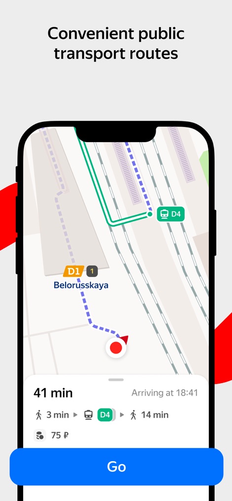
효율적인 대중교통 길찾기
이 앱은 D1 및 D4와 같은 특정 대중교통 노선을 포함한 최적화된 경로를 안내하며, 총 예상 소요 시간(41분)과 비용(75 ₽)을 사용자에게 제공합니다.
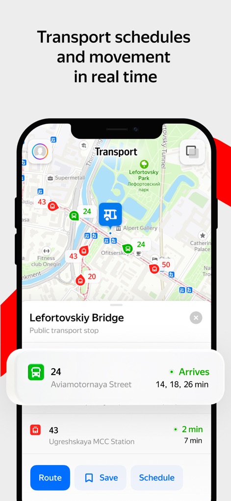
실시간 대중교통 정보
이 도구는 지도상에 버스 정류장 아이콘을 통해 실시간 대중교통 위치를 표시하고, 각 노선(예: 24번 버스)의 예상 도착 시간(14분, 18분, 26분)을 정확하게 제공합니다.
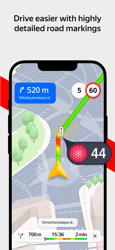
정밀한 도로 안내
사용자는 520m 앞의 방향 전환과 같은 상세한 도로 표시를 통해 복잡한 교차로를 쉽게 탐색할 수 있으며, 실시간 신호등 정보(빨간불 44초)와 제한 속도(60)를 확인할 수 있습니다.
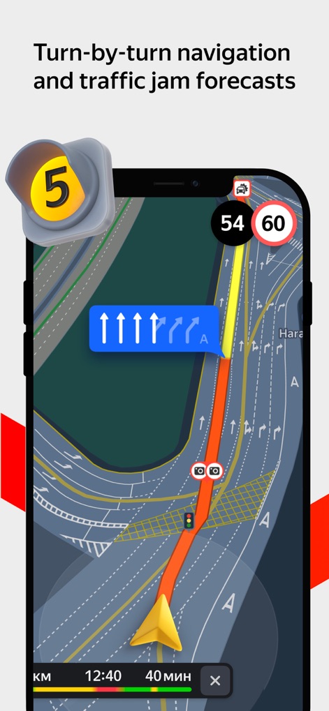
스마트한 턴바이턴 내비게이션
이 내비게이션은 실시간 교통 체증 정보(주황색/빨간색 표시)를 반영하여 최적 경로를 안내하며, 다음 진행 방향을 명확히 보여주는 턴바이턴 지시를 제공합니다.
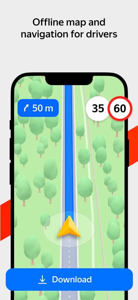
오프라인 드라이브 내비게이션
운전자는 인터넷 연결 없이도 단순화된 오프라인 지도를 사용하여 길을 찾을 수 있으며, 다음 회전까지의 거리(50m)와 현재 주행 속도(35) 정보를 한눈에 파악할 수 있습니다.
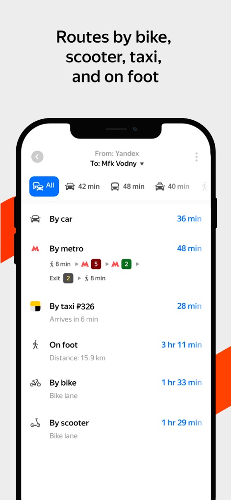
다양한 이동 수단 경로
이 앱은 자동차, 지하철, 도보, 자전거 등 다양한 이동 수단에 대한 경로 옵션을 제시하며, 각 옵션에 대한 예상 소요 시간(예: 지하철 48분)과 택시 요금(326 ₽)을 함께 보여줍니다.
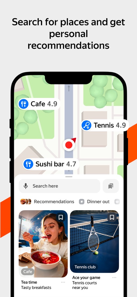
맞춤형 장소 추천
사용자는 지도상에서 카페, 테니스장과 같은 흥미로운 장소 아이콘을 쉽게 찾을 수 있으며, 개인의 관심사에 기반한 이미지 기반 추천 카드(예: Tea time)를 받아볼 수 있습니다.
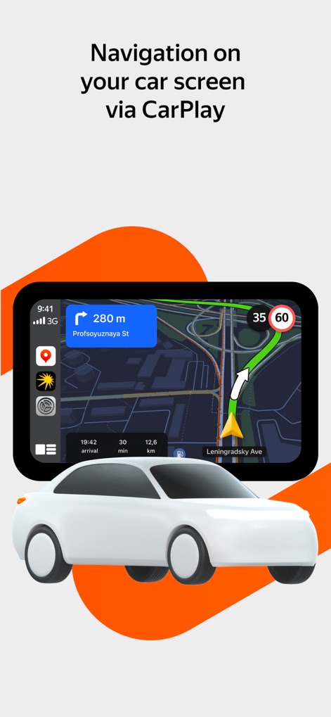
카플레이 연동 내비게이션
이 앱은 애플 카플레이를 통해 자동차 화면에 통합되어 주행 경로를 명확하게 표시하며, 현재 주행 속도(35)와 제한 속도(60) 정보를 동시에 제공합니다.
설명
Download
비슷한 앱
유사한 기능과 사용자 경험을 가진 앱

百度地图-路线规划,出行必备
Beijing Baidu Netcom Science & Technology Co.,Ltd

Citymapper: All Live Transit
Citymapper Limited

GPS智能指南针-北斗卫星导航实时公交定位海拔测亩仪
Chengdu Yichituo Technology Co., Ltd.

Smart 5G Navigation
Chengdu Xinda Network Technology Co., Ltd.

VIP Real-time Map
Guangzhou Jishu Network Technology Co.,Ltd.

北斗导航-3D高清卫星地图Pro
Guangzhou Tianhe District Yongji Network Technology Co., Ltd.

Google Maps
Google LLC

腾讯地图-路线规划,导航地铁打车出行
Shenzhen Tencent Computer Systems Company Limited

KakaoMap - Korea No.1 Map
Kakao Corp.
이 페이지는 앱이나 개발자의 공식 페이지가 아니며, 정보 제공 및 논평을 목적으로 작성된 독립 편집 간행물입니다. 명시적으로 달리 언급되지 않는 한, 해당 앱이나 개발자는 MWM, Apple, Google Play, 앱 퍼블리셔 또는 앱 개발자와 제휴, 보증, 후원, 승인 또는 공식적으로 연결되어 있지 않으며, 이 페이지의 어떤 내용도 해당 앱이 MWM의 서비스를 사용하여 개발되었음을 의미하지 않습니다. 모든 상표, 로고, 스크린샷 및 기타 콘텐츠는 해당 소유자의 자산입니다.