이 페이지는 앱이나 개발자의 공식 페이지가 아니며, 정보 제공 및 논평을 목적으로 작성된 독립 편집 간행물입니다. 명시적으로 달리 언급되지 않는 한, 해당 앱이나 개발자는 MWM, Apple, Google Play, 앱 퍼블리셔 또는 앱 개발자와 제휴, 보증, 후원, 승인 또는 공식적으로 연결되어 있지 않으며, 이 페이지의 어떤 내용도 해당 앱이 MWM의 서비스를 사용하여 개발되었음을 의미하지 않습니다. 모든 상표, 로고, 스크린샷 및 기타 콘텐츠는 해당 소유자의 자산입니다.

Yorkshire Three Peaks
GPS 기반 지도와 국립공원 레인저의 전문가 통찰력을 사용하여 자신감을 가지고 탐색하세요. 트레킹을 계획하고, 안전을 유지하며, 사랑하는 트레일에 보답하세요.
다운로드
58K+사용자 평점
총 평가 수
100개발사
카테고리
Travel지원 언어
1최신 버전
1.7크기
32.9 MB출시일
2013년 9월 11일요크셔 쓰리 피크스 챌린지 마스터하기
국립공원 관리청이 봉우리 정복자 및 모험가를 위해 제작한, 국제적인 버킷 리스트 트레킹을 위한 결정판 디지털 동반자입니다.
정밀 GPS 내비게이션
거친 지형을 가로질러 올바른 길을 안내하도록 설계된 실시간 추적 및 거리 표시기를 사용하여 공식 24마일 순환 루트를 따라가세요.
레인저의 내부 지식
국립공원 레인저가 큐레이션한 고유한 관심 지점과 유산 통찰력을 통해 전문가의 눈으로 풍경을 탐험하세요.
다음 스크린샷과 설명은 앱의 공식 스토어 목록에서 직접 가져온 것이며 앱 개발자의 자산입니다.
앱 스토어
스크린샷
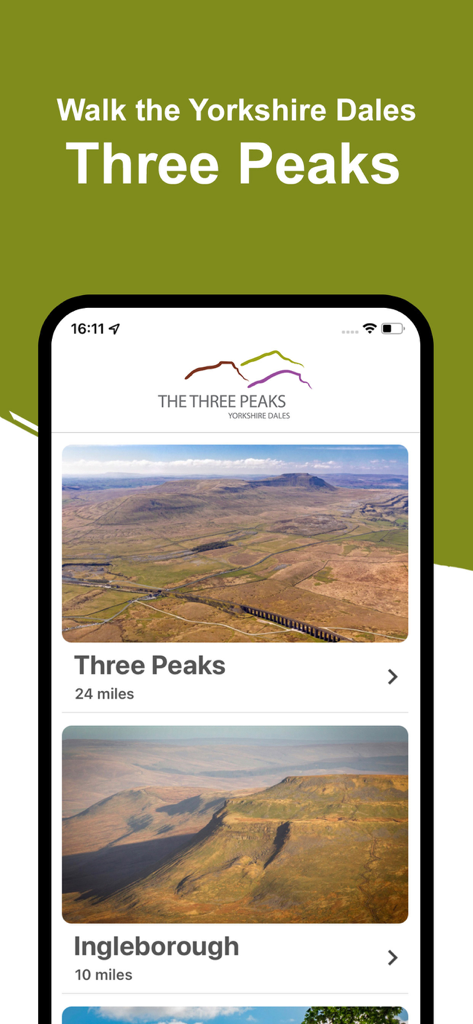
요크셔 쓰리 피크스 모바일 앱 홈 화면으로, 쓰리 피크스와 잉글버러의 하이킹 루트 옵션과 거리 정보가 표시됩니다.
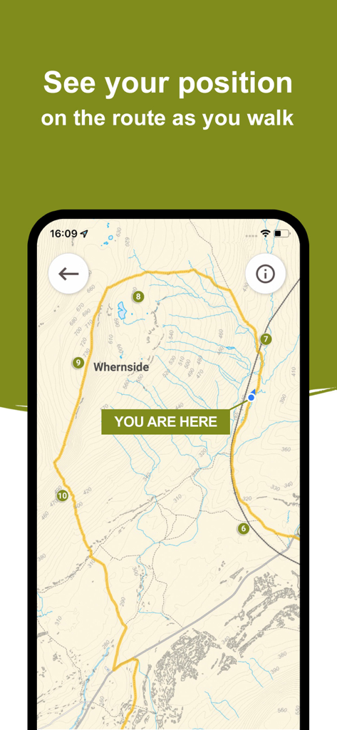
요크셔 쓰리 피크스 앱 내 Whernside 트레일 지도에서 실시간 GPS 추적
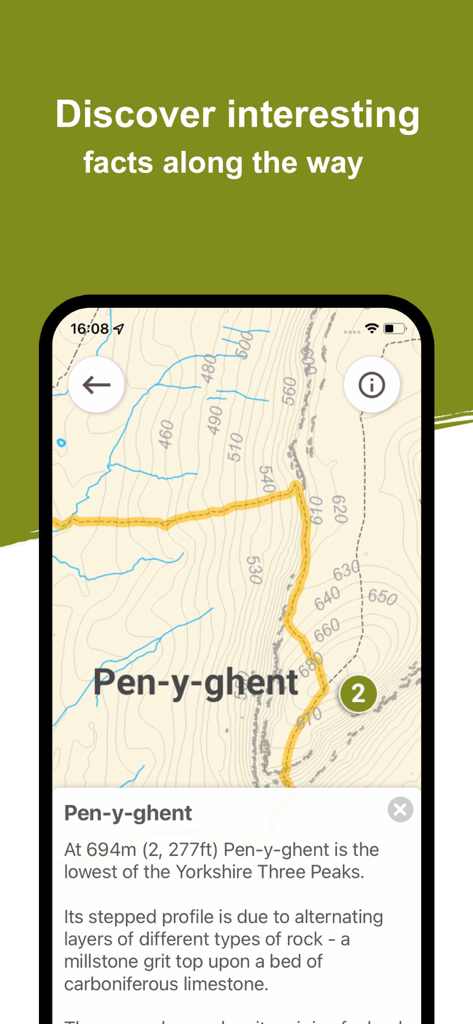
펜-이-젠트의 지형도와 지질학적 사실을 보여주는 앱 인터페이스
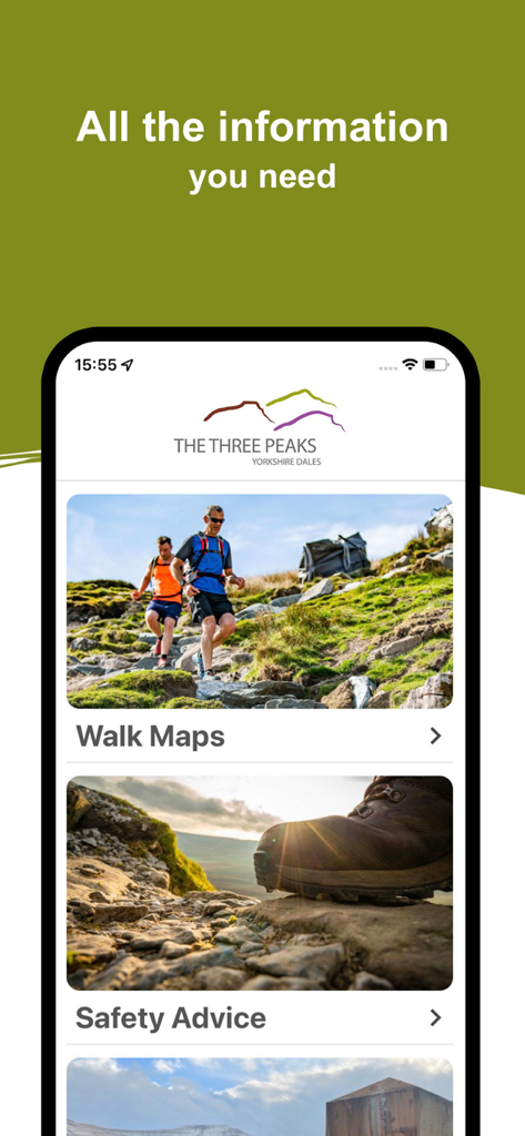
요크셔 쓰리 피크스 모바일 앱 메인 메뉴에 산책 지도와 안전 조언 섹션이 표시됨
설명
Download
비슷한 앱
같은 카테고리의 상위 앱

Uber - Request a ride
Uber Technologies, Inc.

Airbnb
Airbnb, Inc.

铁路12306
ACADEMY OF RAILWAY SCIENCES CO., ltd.

Booking.com: Hotels & Travel
Booking.com B.V.

Grab: Taxi Ride, Food Delivery
GRABTAXI HOLDINGS PTE. LTD.

Trip.com: Book Flights, Hotels
Trip.com Travel Singapore Pte. Ltd.

DiDi China: Ride Hailing
Didi Chuxing (Beijing) Network Platform Technology Co., Ltd

去哪儿旅行-订酒店机票火车票
Beijing Qunar Information Technology Company Limit

Bolt: Request a Ride
BOLT TECHNOLOGY OU
이 페이지는 앱이나 개발자의 공식 페이지가 아니며, 정보 제공 및 논평을 목적으로 작성된 독립 편집 간행물입니다. 명시적으로 달리 언급되지 않는 한, 해당 앱이나 개발자는 MWM, Apple, Google Play, 앱 퍼블리셔 또는 앱 개발자와 제휴, 보증, 후원, 승인 또는 공식적으로 연결되어 있지 않으며, 이 페이지의 어떤 내용도 해당 앱이 MWM의 서비스를 사용하여 개발되었음을 의미하지 않습니다. 모든 상표, 로고, 스크린샷 및 기타 콘텐츠는 해당 소유자의 자산입니다.