This page is not an official page of the app or its developer, but an independent editorial publication created for informational and commentary purposes. Unless expressly stated otherwise, neither the app nor its developer is affiliated with, endorsed by, sponsored by, authorized by, or otherwise officially connected with MWM, Apple, Google Play, the app publisher, or the app's developer, and nothing on this page implies that the app was developed using MWM's services. Any trademarks, logos, screenshots, and other content remain the property of their respective owners.

AirNav Radar – Flight Tracker
Know exactly where every plane is, every time. The app gives users command over the skies, turning complex air traffic data into immediate understanding.
Downloads
1M+User Rating
Total Ratings
4.1KPublisher
Category
TravelLocales
1Latest Version
3.3.2Size
106.6 MBFirst Released
Jul 28, 2018An evaluation of key functionalities driving real-time aviation insights for a diverse user base.
AirNav Radar – Flight Tracker: Core Analytical Features
Real-time Live Flight Tracking and Notifications
The app provides real-time tracking for any flight, delivering instant notifications on status changes, crucial for timely updates.
Detailed Flight and Aircraft Information
It allows users to access individual flight pages, including live position, route, plane photos, and comprehensive details such as aircraft make, model, airline, altitude, and speed.
Airport Arrivals and Departures Monitoring
This tool features the ability to monitor arrivals and departures at any airport worldwide, presenting clear and up-to-date flight status information.
Interactive Radar Map Display
The app displays flights on an interactive radar map, allowing users to visualize most tracked flights and identify emergency aircraft in real-time.
Historical Flight Data Replay
It enables users to replay past flights and review up to 7 days of historical flight data, offering insights into previous routes and timings.
Advanced Multi-Source Tracking Technology
The app utilizes a sophisticated multi-source tracking system, combining ADS-B, ASDI, Oceanic, MLAT, and Satellite data for high-precision real-time flight information.
Frequently Asked Questions
Everything you need to know about AirNav Radar – Flight Tracker
What is AirNav Radar – Flight Tracker?
AirNav Radar is a real-time flight tracker app providing accurate, live aircraft and flight tracking worldwide. It is used by aviation enthusiasts, travelers, pilots, and professionals to track planes from takeoff to landing.
How accurate is AirNav Radar's flight tracking?
AirNav Radar delivers high-precision real-time flight data. It combines data from a global network of over 36,000 receivers, ADS-B, MLAT, satellite, and oceanic sources, making it one of the most accurate trackers.
Does AirNav Radar track flights globally?
Yes, AirNav Radar provides comprehensive global flight coverage. Its network of over 36,000 receivers covers major airports and international flight corridors worldwide, tracking flights over land and remote regions.
What real-time information does AirNav Radar provide for flights?
AirNav Radar provides live flight position, route, aircraft photos, make, model, airline, altitude, and speed. It also offers real-time notifications for flight status changes and arrival/departure monitoring.
Can I replay past flights using AirNav Radar?
Yes, AirNav Radar allows users to replay past flights. The free version offers up to 7 days of historical data, while the Ads-Free plan extends this to 30 days, and the Business Plan to 365 days.
What technology does AirNav Radar use to track aircraft?
AirNav Radar uses a multi-source tracking approach. It combines data from ADS-B transponders, MLAT, ASDI, oceanic data, and satellite, leveraging a global network of over 36,000 receivers.
What are the benefits of the AirNav Radar Ads-Free Plan?
The Ads-Free Plan provides a completely ads-free experience, unlimited access to live airport control tower radio, full flight graphs showing altitude and speed, and access to 30 days of historical flight data and replays.
What advanced features are in the AirNav Radar Pilot Plan?
The Pilot Plan includes all Ads-Free features plus advanced aviation tools. These include terrain, satellite, and aviation map layers, weather layers for airports and routes, and advanced flight and aircraft filtering.
Does AirNav Radar offer a plan for professional use?
Yes, AirNav Radar offers a Business Plan. This plan includes professional-grade tools like up to 365 days of historical data, fleet tracking for multiple aircraft, detailed airport overviews, and expanded raw flight data downloads.
Can AirNav Radar display real-time weather conditions?
Yes, the AirNav Radar Pilot Plan includes weather layers, providing real-time weather conditions for airports and full flight routes. These overlays include cloud coverage, precipitation, and wind barbs.
Does AirNav Radar have an augmented reality feature?
Yes, AirNav Radar includes an Augmented Reality feature. Users can point their camera to the sky to instantly identify planes above them and view their flight details in real-time.
Can AirNav Radar show detailed information about an aircraft?
Yes, AirNav Radar provides detailed aircraft information. This includes the aircraft's make, model, airline, registration, serial number, age, and even seat map configuration.
Does AirNav Radar show live airport departure and arrival boards?
Yes, AirNav Radar features Live Flight Boards. Users can monitor arrivals and departures at any airport worldwide, viewing clear flight status updates for each flight.
The following screenshots and description are sourced directly from the app's official store listing and are the property of the app developer.
App Store
Screenshots
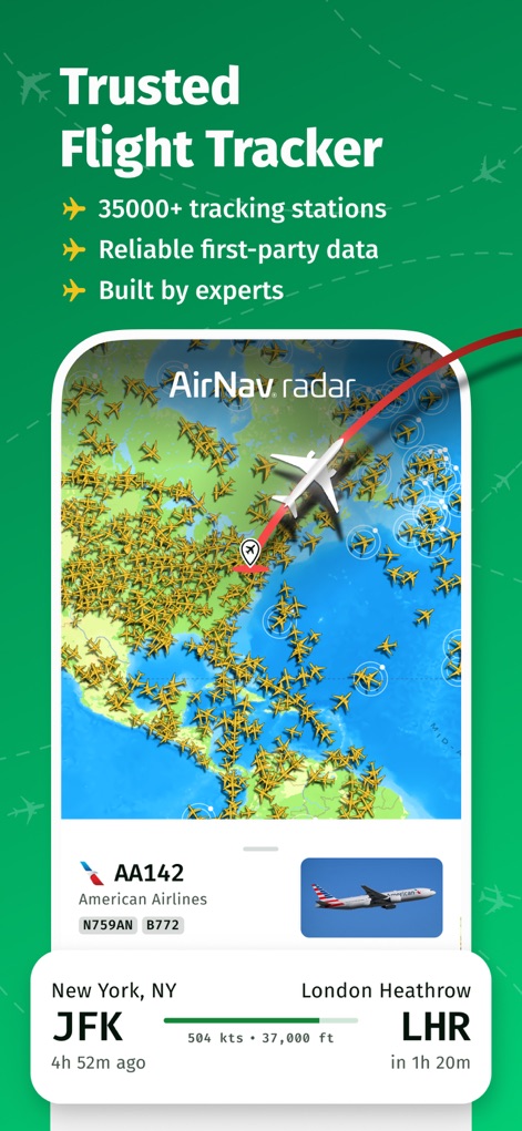
See how this tool displays a vast network of aircraft on a real-time map and provides immediate flight details like altitude and speed.
Global Coverage Map
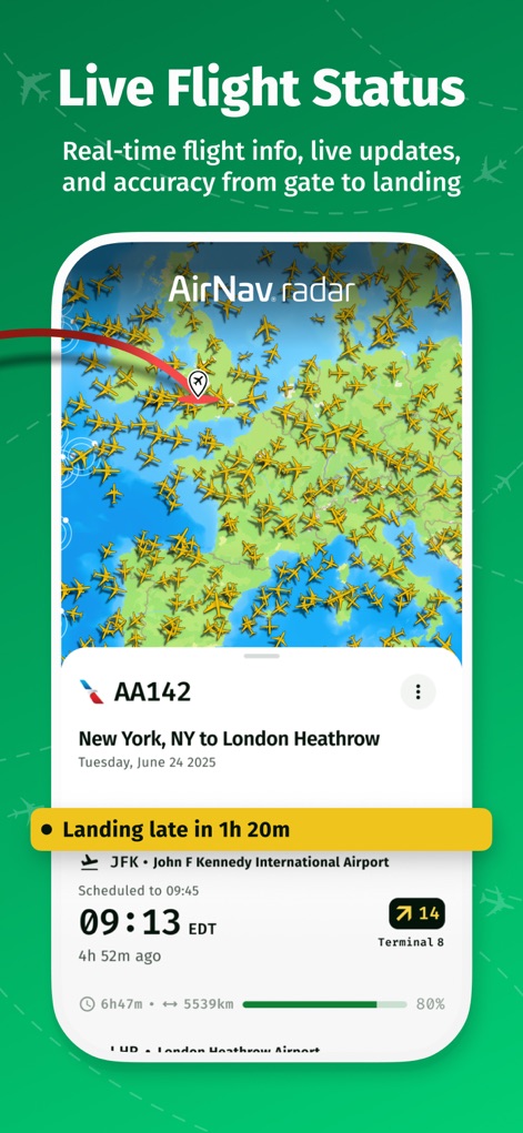
This app offers immediate flight status notifications, clearly displaying updates like "Landing late" and essential details such as scheduled times and terminal gates.
Real-time Updates
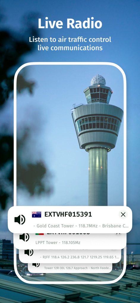
Users can tune into live air traffic control communications, with the app providing easy access to multiple tower frequencies and clear audio playback options.
ATC Communications

Explore comprehensive aircraft information, including specific models like the Airbus A380 and visual representations of seat map configurations, providing in-depth data for aviation enthusiasts.
Detailed Aircraft Specs

Point your camera to the sky and instantly identify flights overhead, revealing real-time data such as altitude and ground speed in an augmented reality overlay.
AR Flight Finder

This screen showcases a captivating gallery of diverse aircraft types, from commercial airliners to unique specialized planes, inspiring users to explore various interesting flights.
Aviation Photography
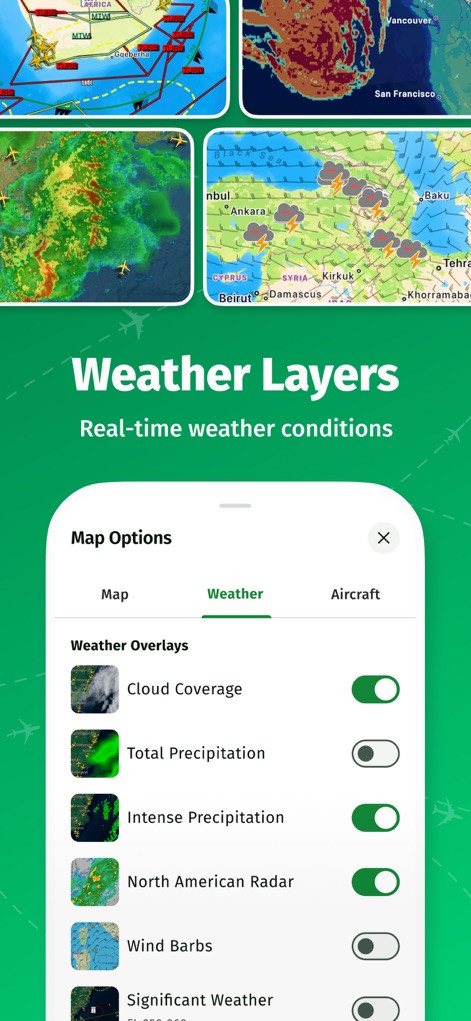
Users can overlay detailed real-time weather conditions onto their flight maps, selecting from options like cloud coverage and wind barbs for enhanced situational awareness.
Advanced Weather Mapping
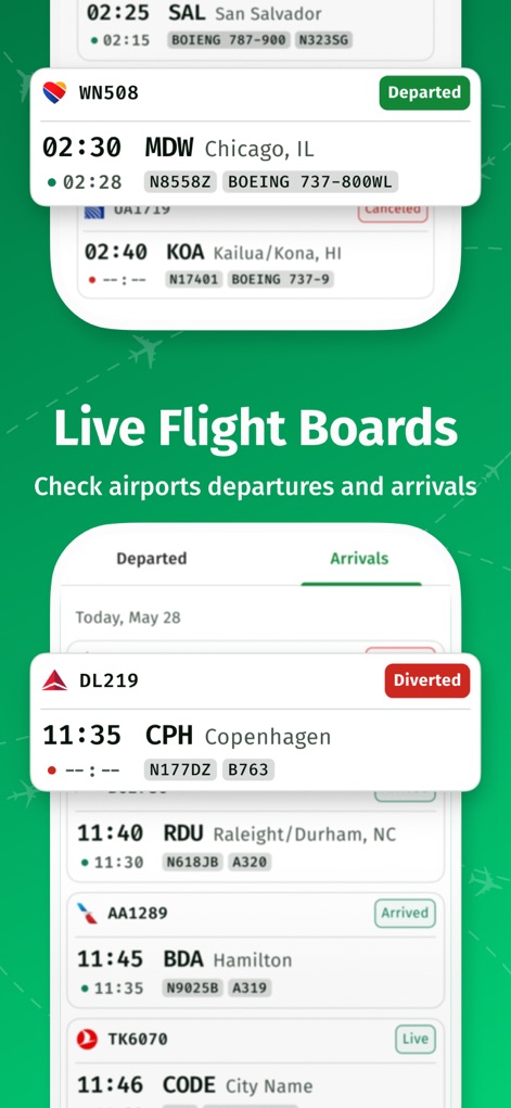
Check comprehensive live flight boards for arrivals and departures at any airport, providing instant updates on flight status and specific gate information.
Airport Board View

Discover why aviation professionals praise this app, featuring glowing testimonials from industry experts and prominent media mentions, reinforcing its reliability.
Expert Endorsements
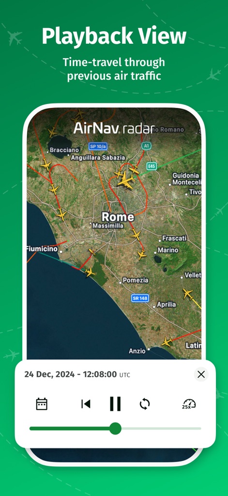
Time-travel through previous air traffic with the playback view, allowing users to review historical flight paths and precise timestamped data for detailed analysis.
Historical Flight Replay
Description
Download
More Like This
Apps with similar features and user experience

Flightradar24 | Flight Tracker
Flightradar24 AB

飞常准-航班动态机票购买查询追踪值机
FEEYO.COM E-COMMERCE CORP.

Flighty – Live Flight Tracker
Flighty LLC

Flight Tracker: Plane Radar 24
Oleksandr Vynnyk

FlightStats
LNRS Data Services Limited

AirHelp・Flight Tracker
AirHelp Germany GmbH

Spot the Station
NASA

Flight Tracker & Radar
ISLAND STORM LABS LIMITED

Flight Tracker - Plane Status
Discover Ukraine LLC
This page is not an official page of the app or its developer, but an independent editorial publication created for informational and commentary purposes. Unless expressly stated otherwise, neither the app nor its developer is affiliated with, endorsed by, sponsored by, authorized by, or otherwise officially connected with MWM, Apple, Google Play, the app publisher, or the app's developer, and nothing on this page implies that the app was developed using MWM's services. Any trademarks, logos, screenshots, and other content remain the property of their respective owners.