This page is not an official page of the app or its developer, but an independent editorial publication created for informational and commentary purposes. Unless expressly stated otherwise, neither the app nor its developer is affiliated with, endorsed by, sponsored by, authorized by, or otherwise officially connected with MWM, Apple, Google Play, the app publisher, or the app's developer, and nothing on this page implies that the app was developed using MWM's services. Any trademarks, logos, screenshots, and other content remain the property of their respective owners.

Light Pollution Map - Dark Sky
Locate the darkest skies, track live auroras, and master the night. The all-in-one precision tool for stargazers, photographers, and outdoor explorers.
Downloads
611K+User Rating
Total Ratings
1K+Publisher
Category
WeatherLocales
1Latest Version
5.5.0Size
95.6 MBFirst Released
Feb 17, 2017Everything You Need to Master the Night
From pinpointing the darkest camping spots to tracking the Northern Lights, we provide the precision data you need for the ultimate stargazing experience.
Interactive Dark Sky Maps
Find the clearest, darkest skies for photography and observation with high-resolution light pollution data tailored for your next escape.
Instant Event Notifications
Never miss a rare celestial event with real-time push alerts for meteor showers, super moons, and local aurora activity.
Frequently Asked Questions
Everything you need to know about Light Pollution Map - Dark Sky
What is the main purpose of the Light Pollution Map - Dark Sky app?
The Light Pollution Map - Dark Sky app helps users locate dark sky areas unaffected by light pollution for stargazing, night sky photography, and observing celestial events.
Does Light Pollution Map - Dark Sky provide aurora borealis tracking?
Yes, the Light Pollution Map - Dark Sky app provides live aurora borealis information, including KP value, magnetic field data, and a live visibility map for both hemispheres.
How much does the Light Pollution Map - Dark Sky Pro version cost?
The Light Pollution Map - Dark Sky Pro version costs $9.99 USD for a yearly subscription. This price renews annually.
Can I track the International Space Station (ISS) with Light Pollution Map - Dark Sky?
Yes, Light Pollution Map - Dark Sky includes an ISS Tracker that provides live updates on the International Space Station's location, visibility, velocity, and altitude.
Does the Light Pollution Map - Dark Sky app show moon phase information?
Yes, the Light Pollution Map - Dark Sky app provides comprehensive moon information, including moon phase, rise and set times, and dates for upcoming full and new moons.
How does the Light Pollution Map - Dark Sky app help find clear skies?
The Light Pollution Map - Dark Sky app provides a local cloud coverage indicator and a cloud cover overlay on the main map to help users find clear sky locations.
Does Light Pollution Map - Dark Sky offer alerts for celestial events?
Yes, Light Pollution Map - Dark Sky offers alerts and push notifications for local and global aurora borealis activity, meteor showers, super moons, and lunar eclipses.
Can I save my favorite dark sky locations in Light Pollution Map - Dark Sky?
Yes, Light Pollution Map - Dark Sky allows users to save and load their favorite dark sky locations and navigate to them using the Apple Maps app.
Is an internet connection required to use the Light Pollution Map - Dark Sky app?
Yes, the Light Pollution Map - Dark Sky app requires an active internet connection or Wi-Fi to load data.
What types of celestial events are listed in the Night Event Calendar within Light Pollution Map - Dark Sky?
The Night Event Calendar in Light Pollution Map - Dark Sky lists dates for events like lunar eclipses, super moons, and meteor showers, such as the Perseids.
The following screenshots and description are sourced directly from the app's official store listing and are the property of the app developer.
App Store
Screenshots
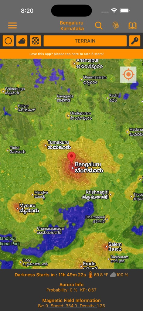
Interactive light pollution map showing terrain and darkness data for stargazing
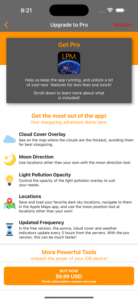
Screenshot of the Light Pollution Map Pro version upgrade screen listing premium features and subscription price
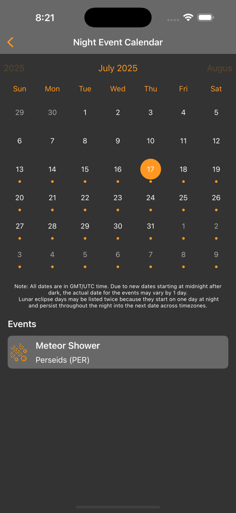
A mobile screen showing a night event calendar with a Perseids meteor shower notification.
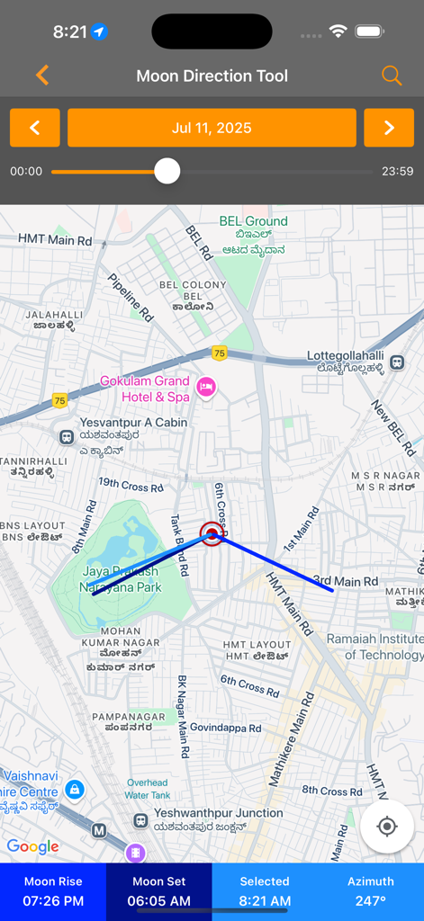
Moon direction tool interface showing position on a map for stargazing planning
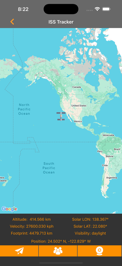
International Space Station real time tracker map with altitude and velocity data
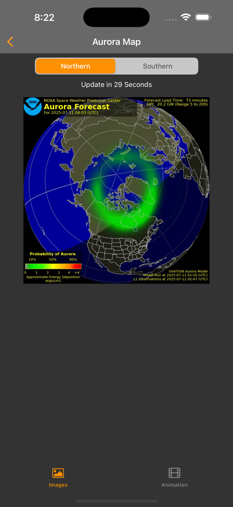
A screenshot of the Aurora Map screen in the Light Pollution Map app showing the Northern Lights forecast over a map of the Northern Hemisphere.
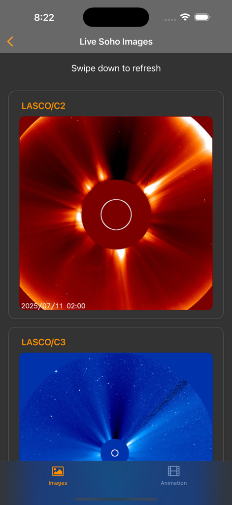
Live solar images from the SOHO mission showing sun coronagraphs
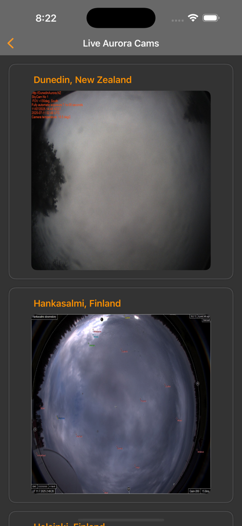
A mobile interface showing live aurora camera feeds from New Zealand and Finland
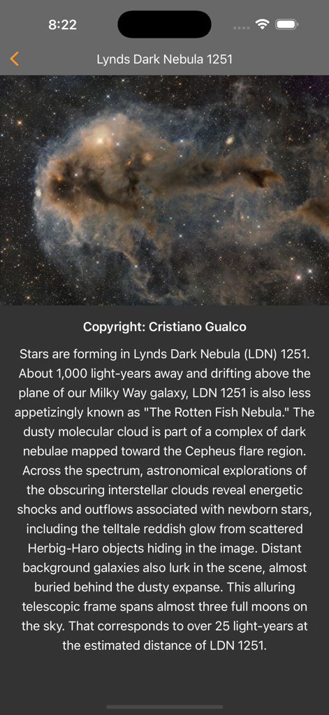
Astronomy photo of the day showing Lynds Dark Nebula 1251 within the app
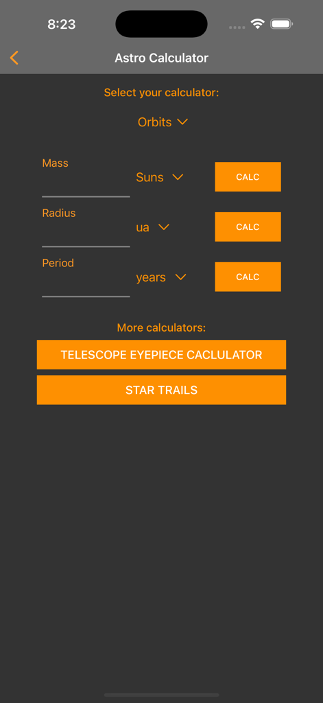
Astro Calculator screen showing orbital calculations telescope eyepiece tool and star trails settings
Description
Download
More Like This
Apps with similar features and user experience

Moon Phases and Lunar Calendar
Business City s.r.o.

My Moon Phase - Lunar Calendar
JRustonApps B.V.

The Moon: Calendar Moon Phases
Vitalii Gryniuk

Moonlitt: Moon Phase Tracker
Flipping Hues Srls

Sunrise Sunset Times
Fascinating Projects Pty Ltd

PhotoPills
PhotoPills S.L.

AuroraReach
HuskyCodes Oy

Sun Seeker - Sunlight Tracker
Ajnaware Pty Ltd

Sun Tracker AR
Zuzana Eskinasi
This page is not an official page of the app or its developer, but an independent editorial publication created for informational and commentary purposes. Unless expressly stated otherwise, neither the app nor its developer is affiliated with, endorsed by, sponsored by, authorized by, or otherwise officially connected with MWM, Apple, Google Play, the app publisher, or the app's developer, and nothing on this page implies that the app was developed using MWM's services. Any trademarks, logos, screenshots, and other content remain the property of their respective owners.