This page is not an official page of the app or its developer, but an independent editorial publication created for informational and commentary purposes. Unless expressly stated otherwise, neither the app nor its developer is affiliated with, endorsed by, sponsored by, authorized by, or otherwise officially connected with MWM, Apple, Google Play, the app publisher, or the app's developer, and nothing on this page implies that the app was developed using MWM's services. Any trademarks, logos, screenshots, and other content remain the property of their respective owners.

Marine Barograph
Transform your device into a high-performance electronic barograph. Log atmospheric pressure, GPS position, and trends automatically to stay ahead of the weather and maintain a precise digital log of your voyage.
Downloads
61K+User Rating
Total Ratings
0Publisher
Category
WeatherLocales
-Latest Version
3.0.1Size
60.6 MBFirst Released
Dec 18, 2020Precision Barography for the Serious Mariner
Transform your iPhone or iPad into a professional-grade marine instrument. Track high-accuracy pressure trends, log your voyage data, and stay ahead of the weather with reliability you can trust offshore.
Advanced Pressure Tendency Tracking
Visualize up to 16 days of historical data and calculate official pressure tendency codes to detect storm fronts before they reach your position.
Automated Voyage Logging
Securely log atmospheric pressure, GPS position, and speed in the background. Export your complete voyage track as a GPX file for professional navigation software.
Frequently Asked Questions
Everything you need to know about Marine Barograph
What is the Marine Barograph app?
The Marine Barograph app is an enhanced barograph for marine and land travel. It automatically stores atmospheric pressure, GPS data, course, and speed, providing detailed pressure trend analysis and export capabilities.
Does the Marine Barograph app record pressure data automatically?
Yes, the Marine Barograph app automatically stores atmospheric pressure data. It records pressure, time, date, GPS position, course over ground, and speed over ground, even when running in the background.
How long can the Marine Barograph app graph pressure data?
The Marine Barograph app can graph pressure data over various time intervals. These range from 30 minutes up to 16 days, allowing for comprehensive trend analysis.
Can I view the collected data in the Marine Barograph app?
Yes, you can view the stored data directly within the Marine Barograph app. It provides a log of voyage or land travel, including navigation information and pressure data.
How can I export data from the Marine Barograph app?
The Marine Barograph app allows you to export stored pressure data and GPS tracks. Pressure data can be exported by time range, and GPS positions can be exported as a GPX file.
Does Marine Barograph display pressure trend arrows?
Yes, the Marine Barograph app displays prominent pressure trend arrows. These arrows indicate the pressure trend based on changes over the past one hour, aiding weather analysis.
Can the Marine Barograph app share data wirelessly?
Yes, the Marine Barograph app shares both pressure and position information wirelessly. It broadcasts data via WIFI in UDP mode on a user-selected port, acting as a source for other navigation systems.
What options are available for pressure display in Marine Barograph?
The Marine Barograph app offers options for pressure display. Users can choose between sea level or station pressure, and adjust the precision and latitude and longitude formats in the settings.
Can I use an old iPhone as a dedicated barograph with Marine Barograph?
Yes, the Marine Barograph app can convert an older iPhone (iPhone 6 or newer) into a valuable stand-alone electronic barograph and voyage data logger. It provides continuous viewing when plugged in.
Does the Marine Barograph app include a help file?
Yes, the Marine Barograph app includes a full Help file. It details operation and provides tips on using atmospheric pressure for navigation, and is also viewable online.
The following screenshots and description are sourced directly from the app's official store listing and are the property of the app developer.
App Store
Screenshots
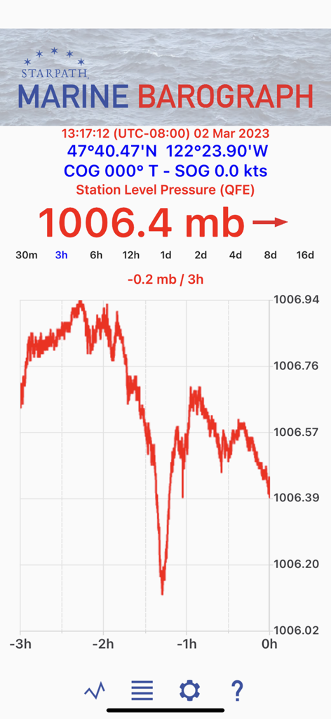
Marine Barograph app display showing real-time atmospheric pressure trends and GPS coordinates
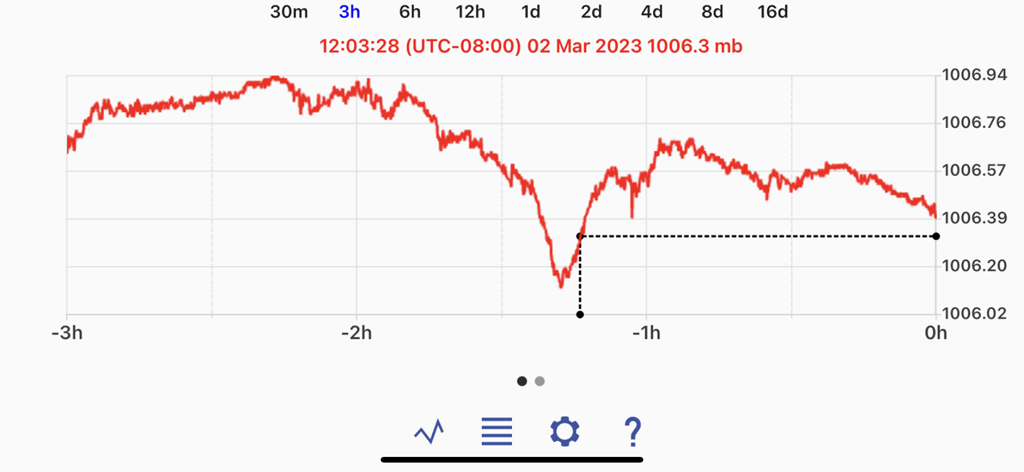
Marine Barograph app display showing a three hour atmospheric pressure history graph
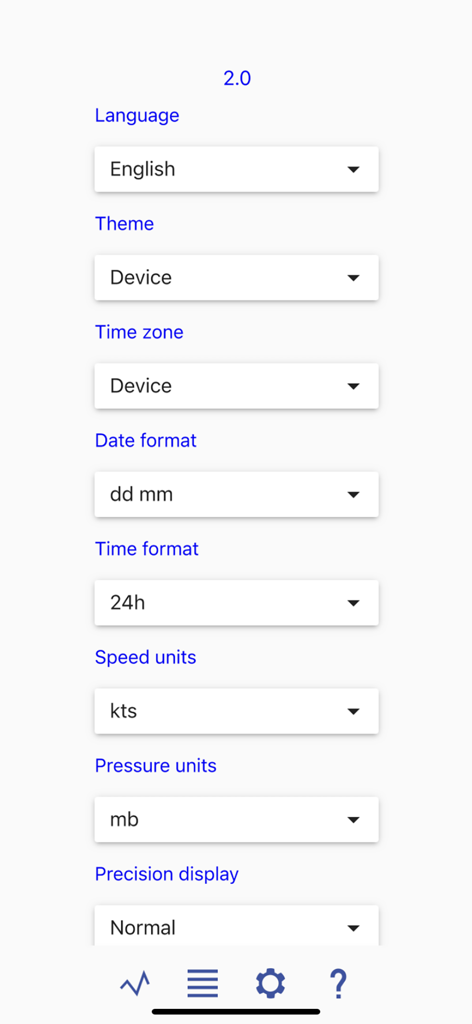
Settings menu of the Marine Barograph app showing configuration options for language, time zone, and measurement units.

Settings menu of the Marine Barograph app showing pressure and position configuration
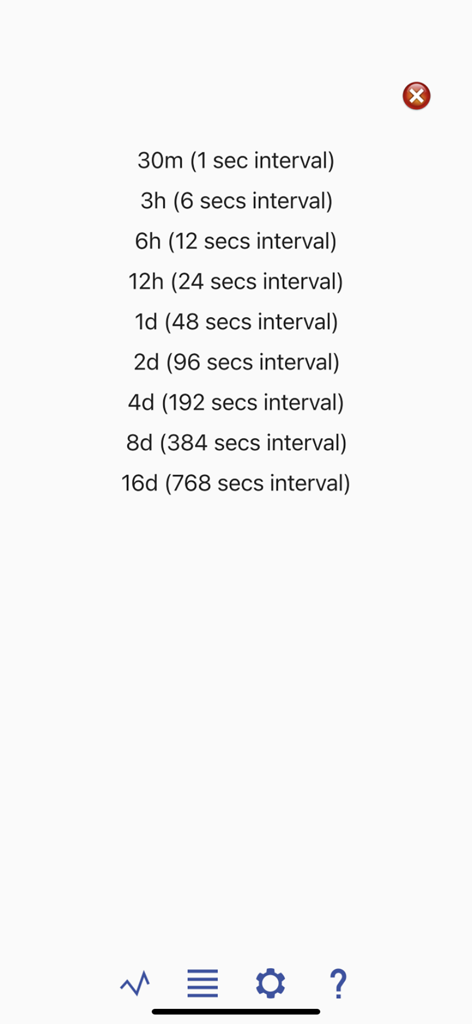
List of time and pressure recording intervals in the Marine Barograph app
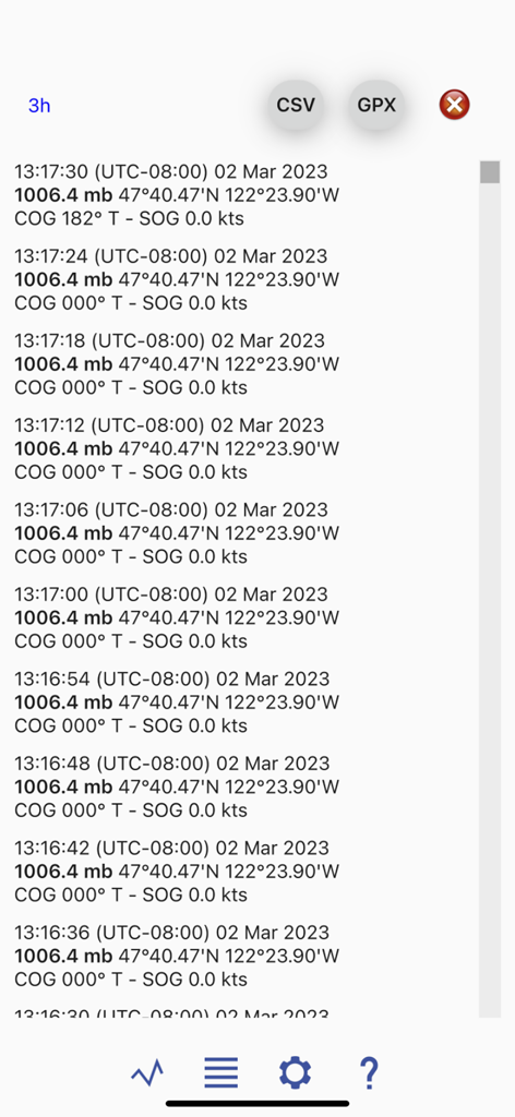
Detailed log of barometric pressure and GPS navigation data in the Marine Barograph app
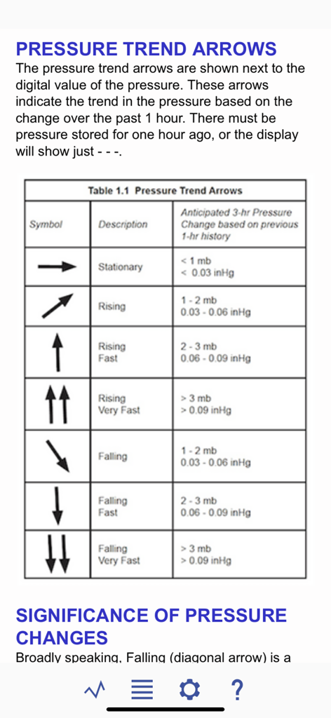
A chart explaining the meaning of barometric pressure trend arrows in the Marine Barograph app
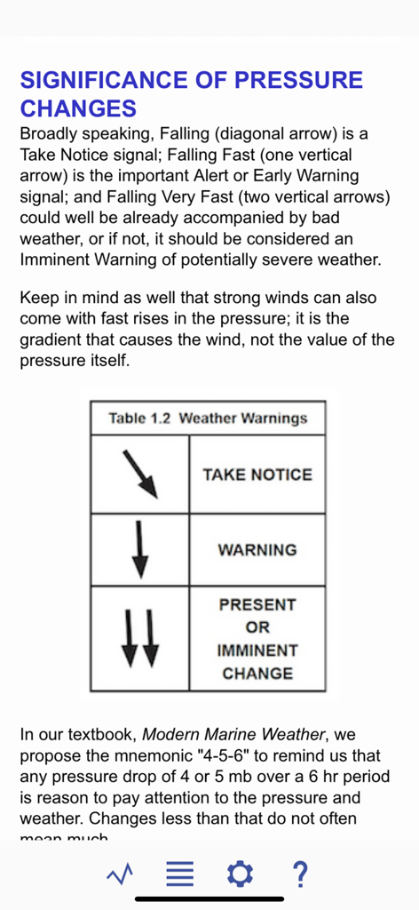
A help screen from the Marine Barograph app explaining the significance of pressure changes with a weather warnings table.
Description
Download
More Like This
Top-ranked apps in the same category

墨迹天气-MojiWeather
Beijing MojiFengyun Technology Co.,Ltd.

The Weather Channel - Radar
The Weather Channel

Windy.com
Windyty, SE

天气预报-精准15日天气预报
Chongqing Caochen Technology Co., Ltd.

My Aurora Forecast & Alerts
JRustonApps B.V.

AccuWeather: Weather Forecast
AccuWeather International, Inc.

Weather & Radar - Storm radar
WetterOnline - Meteorologische Dienstleistungen GmbH

天气通
Weibo Internet Technology (China) Co.Ltd.

The Thermometer -Digital-
Vida Apps Incorporated
This page is not an official page of the app or its developer, but an independent editorial publication created for informational and commentary purposes. Unless expressly stated otherwise, neither the app nor its developer is affiliated with, endorsed by, sponsored by, authorized by, or otherwise officially connected with MWM, Apple, Google Play, the app publisher, or the app's developer, and nothing on this page implies that the app was developed using MWM's services. Any trademarks, logos, screenshots, and other content remain the property of their respective owners.