このページはアプリまたはその開発者の公式ページではなく、情報提供および論評を目的として作成された独立した編集出版物です。明示的に別段の記載がない限り、アプリおよびその開発者は、MWM、Apple、Google Play、アプリのパブリッシャー、またはアプリの開発者と提携、承認、後援、認可、またはその他の公式的な関係はなく、このページのいかなる内容も、アプリがMWMのサービスを使用して開発されたことを意味するものではありません。すべての商標、ロゴ、スクリーンショット、その他のコンテンツはそれぞれの所有者の財産です。

Boat Beacon
自信と安心感を持って航海しましょう。高価なハードウェアなしで、リアルタイムのAISデータ、水平線を超える衝突アラーム、拡張現実ビューをiPhoneまたはApple Watchで直接取得できます。
ダウンロード
278K+ユーザー評価
評価数
2K+開発元
カテゴリ
Navigation対応言語
4最新バージョン
5.0.12サイズ
150.5 MBリリース日
2012年2月16日絶対的な自信を持って航海しましょう
お使いのデバイスをプロフェッショナルグレードのAISシステムに変えましょう。高価な外部ハードウェアを必要とせずに、リアルタイムの衝突警報と船舶追跡で安全を確保しましょう。
スマート衝突回避
アプリがバックグラウンドでも動作する、継続的なCPA計算とアラームにより、潜在的な衝突に対する即時アラートを受け取れます。
ハードウェア不要のAIS
携帯電話データを使用して位置情報を送受信し、トランスポンダーを設置せずに他の船舶や地上局から視認できるようにします。
よくある質問
について知っておくべきこと Boat Beacon
Boat Beaconの主な機能は何ですか?
Boat Beaconは、iPhoneおよびiPad向けのインターネットAIS受信機および送信機です。衝突警報、リアルタイムAISデータを提供し、あなたの船の位置情報を共有します。
Boat Beaconは外部AISハードウェアを必要としますか?
いいえ、Boat Beaconは外部AISトランスポンダーまたは受信機機器を必要としません。インターネットアクセスを使用してデータの送受信を行います。
Boat Beaconはどのように衝突回避を提供しますか?
Boat Beaconは、最大30マイルの水平線を超えた衝突回避を提供します。接近点(CPA)を継続的に計算し、警報とともに潜在的な衝突コースについてユーザーに警告します。
Boat Beaconは私の船の位置を他の人と共有できますか?
はい、Boat BeaconはインターネットAISシステム、他のBoat Beaconユーザー、およびアプリとリアルタイムでインターネット経由で船の位置を共有します。
Boat BeaconにはApple Watchアプリがありますか?
はい、Boat BeaconにはApple Watchアプリが含まれています。速度、コース、進路を表示するリアルタイムナビゲーションディスプレイをApple Watchで直接提供します。
Boat Beaconで利用可能な海洋チャートの種類は何ですか?
Boat Beaconは、アプリ内購入(IAP)として、米国、英国、アイルランドの海洋ラスターチャートを提供しています。これらのチャートは、特定の地域の詳細なナビゲーション情報を提供します。
Boat Beaconの「AIS共有」サブスクリプションの費用はいくらですか?
Boat Beaconの「AIS共有」サブスクリプションは、月額5.99ドルまたは年額16.49ドルです。少なくとも24時間前にキャンセルされない限り、自動更新されます。
Boat Beaconは公式の海洋ナビゲーションのために認定されていますか?
いいえ、Boat Beaconは明確に「ナビゲーション用ではない」とされています。基本的なナビゲーション参照としてのみ機能し、正確な海上ナビゲーションのために単独で依存すべきではありません。
Boat Beaconはマン・オーバー・ボード(MOB)インシデントを追跡できますか?
はい、Boat Beaconにはアプリ内購入としてマン・オーバー・ボード(MOB)追跡機能が含まれています。この機能は、追跡および救助活動を支援するために現在の位置にタグを付けます。
Boat Beaconは拡張現実(AR)機能をサポートしていますか?
はい、Boat Beaconにはアプリ内購入で利用可能な拡張現実(AR)ビューであるLiveViewが搭載されています。これは、カメラフィードに船、コンパス、地平線を重ねて表示します。
Boat Beaconは船の情報をどのように表示しますか?
Boat Beaconは、北向きまたは進路向きモードのマップビューで詳細な船情報を表示します。ユーザーはMMSI、速度、コース、CPAなどの特定の船の詳細も表示できます。
以下のスクリーンショットと説明は、アプリの公式ストアリスティングから直接取得されたものであり、アプリ開発者の所有物です。
アプリストア
スクリーンショット
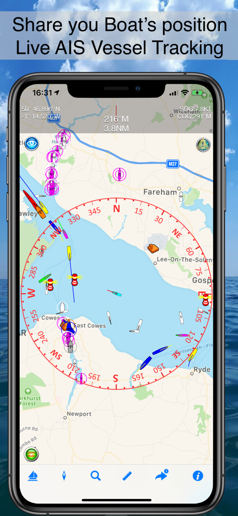
海図上のライブAIS船舶追跡を表示するBoat Beaconモバイルアプリインターフェイス。
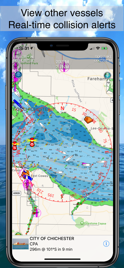
海図上でリアルタイム船舶追跡と衝突警報を表示するBoat Beaconアプリインターフェイス
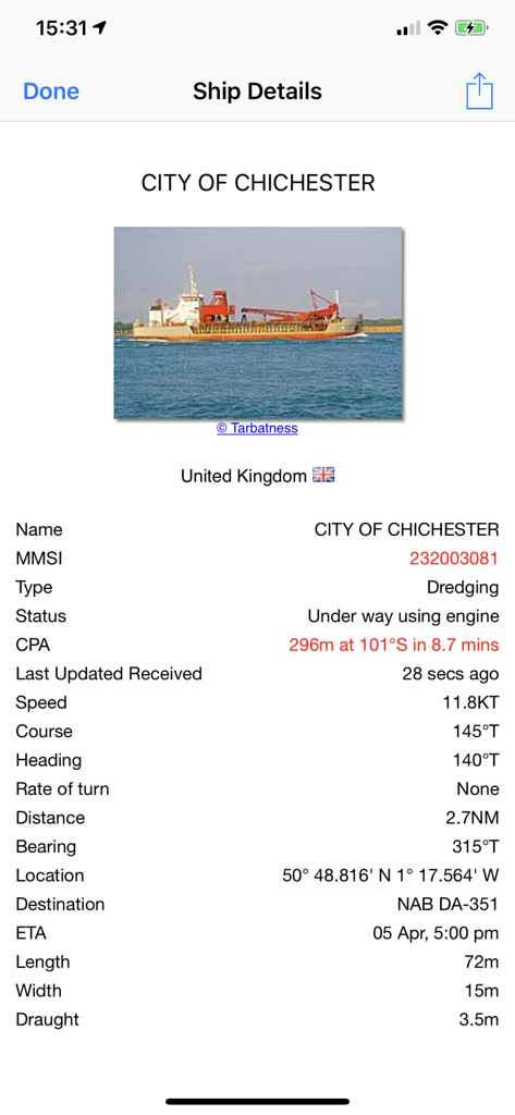
詳細なAIS船舶データと衝突警報情報を表示するBoat Beaconアプリ
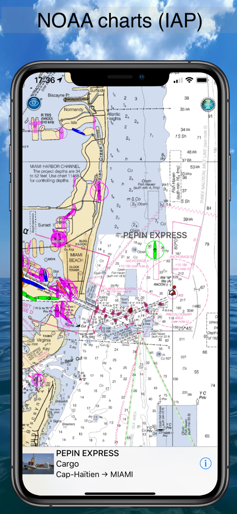
マイアミ港のリアルタイムAIS船舶追跡を表示するNOAA海図を表示するBoat Beaconアプリ。
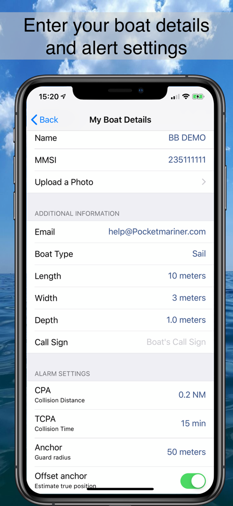
衝突距離やアンカーウォッチなどの船の仕様と海洋安全アラーム設定を表示するBoat Beaconアプリ画面。
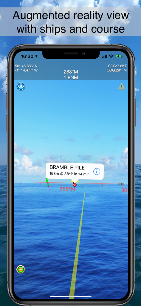
リアルタイムの海の景色に重ねて表示される黄色のコースラインと船舶情報が表示された、Boat Beaconの拡張現実LiveViewを示すスマートフォンの画面。
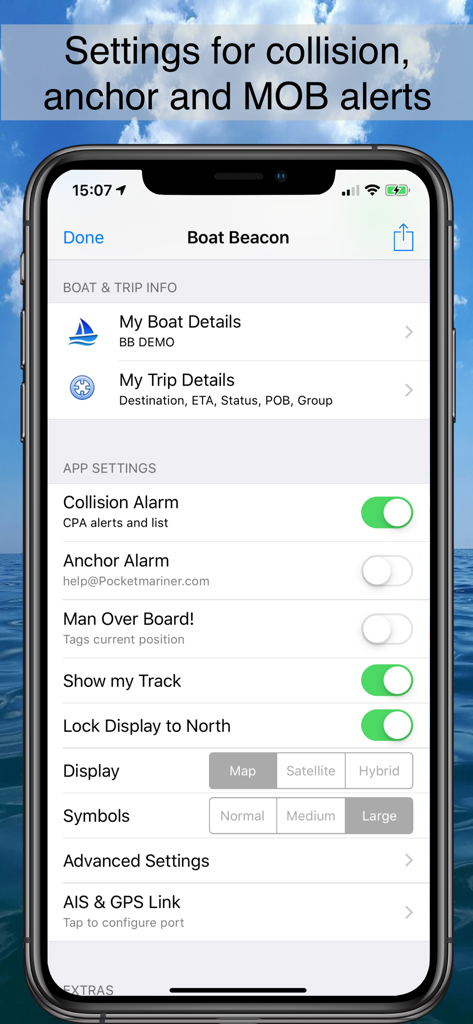
衝突、アンカー、マンオーバーボードアラートの設定を表示するBoat Beaconアプリ設定画面
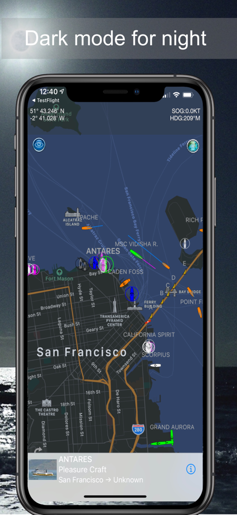
夜間航行用のダークモードでのAIS船舶追跡を表示するBoat Beaconアプリ
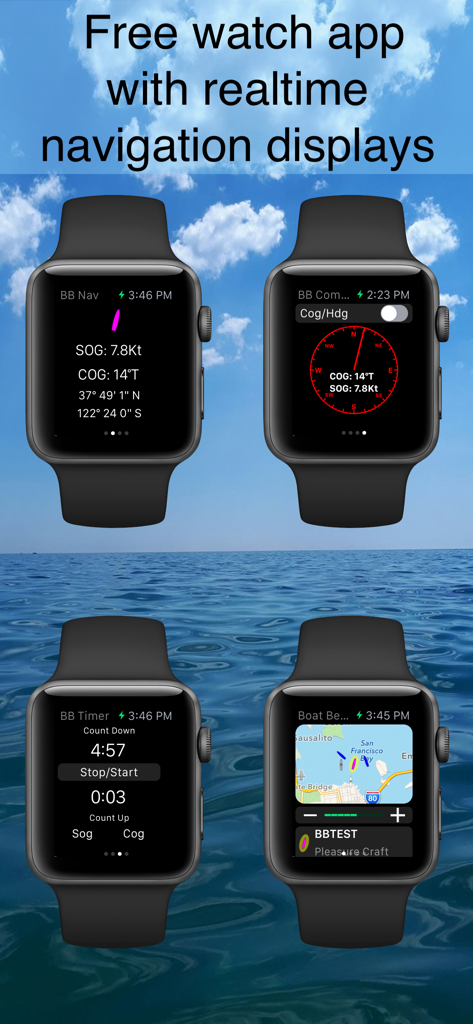
ナビゲーションデータ、コンパス、タイマー、マップビューを表示するBoat Beacon Apple Watchアプリインターフェイス
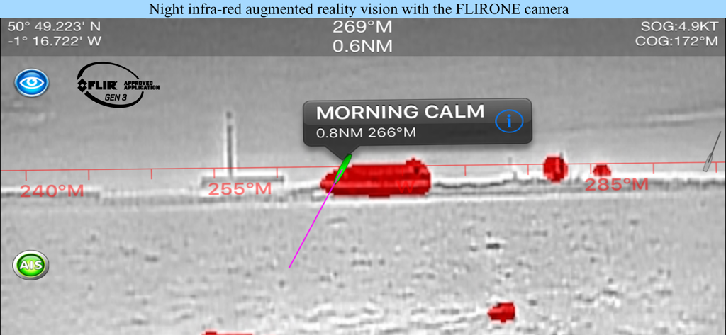
FLIR ONEカメラで船舶を識別するBoat Beaconの夜間赤外線拡張現実ビュー
説明
Download
類似アプリ
似た機能とユーザー体験を持つアプリ

Ship Info
Oleksiy Koldunov

Ship Tracker
Rocketech sp. z o.o.

Boat Watch - Ship Tracking
Pocket Mariner Ltd.

MarineRadar・Vessel Finder
Lascade LLC

Marine Traffic :Ship Tracker
Kathy Spencer

MyShipTracking
Nativity

Boat Watch Pro
Pocket Mariner Ltd.

Ship Finder
pinkfroot limited

Ship Finder Lite
pinkfroot limited
このページはアプリまたはその開発者の公式ページではなく、情報提供および論評を目的として作成された独立した編集出版物です。明示的に別段の記載がない限り、アプリおよびその開発者は、MWM、Apple、Google Play、アプリのパブリッシャー、またはアプリの開発者と提携、承認、後援、認可、またはその他の公式的な関係はなく、このページのいかなる内容も、アプリがMWMのサービスを使用して開発されたことを意味するものではありません。すべての商標、ロゴ、スクリーンショット、その他のコンテンツはそれぞれの所有者の財産です。