このページはアプリまたはその開発者の公式ページではなく、情報提供および論評を目的として作成された独立した編集出版物です。明示的に別段の記載がない限り、アプリおよびその開発者は、MWM、Apple、Google Play、アプリのパブリッシャー、またはアプリの開発者と提携、承認、後援、認可、またはその他の公式的な関係はなく、このページのいかなる内容も、アプリがMWMのサービスを使用して開発されたことを意味するものではありません。すべての商標、ロゴ、スクリーンショット、その他のコンテンツはそれぞれの所有者の財産です。

ダウンロード
5M+ユーザー評価
評価数
8.3K開発元
カテゴリ
Navigation対応言語
1最新バージョン
26.13.0サイズ
724.1 MBリリース日
2019年11月4日高度なオフロードナビゲーションと計画ツールの評価
「onX Offroad: Trail Maps & GPS」主要機能分析
オフラインマップ & GPSナビゲーション
このアプリは、携帯電話の電波が届かない遠隔地でも、インタラクティブな地図データをデバイスに保存し、ユーザーが正確なGPSナビゲーションを継続して利用できるようにします。
詳細なオフロードトレイル情報
本ツールは、アクティビティタイプ、難易度、および車両タイプ(4x4、ATV、スノーモービルなど)でフィルタリング可能な20,000以上のガイド付きトレイル情報を提供します。トレイルのオープン/クローズ状況や写真も確認可能です。
土地所有者情報 & 地図レイヤー
ユーザーは、全国の私有地の境界線と所有者情報を確認できます。また、国立森林、BLM(米国土地管理局)、国立公園などの公有地を識別するための多様な地図レイヤーを利用できます。
分散型キャンプ地の特定
この機能は、米国森林局(USFS)によって検証されたデータに基づくレイヤーを通じて、国立森林内にある合法的かつ無料の分散型キャンプエリアを特定することを可能にします。
カスタムルート作成 & ウェイポイント
利用者は、道路や既存のトレイルに自動的にスナップするカスタムルートを作成し、キャンプ地、ガソリンスタンド、トレイルヘッド、障害物などの重要な地点をウェイポイントとして地図上にマークできます。
3Dマッピング & 地形表示
本アプリは、高解像度の地形図、衛星画像、またはハイブリッド画像を表示する3D GPSナビゲーション機能を提供し、ユーザーが複雑な地形をより詳細に把握し、計画を立てることを支援します。
携帯電話カバレッジ情報
ユーザーは、主要な携帯電話キャリア(AT&T、Verizon、T-Mobile)ごとのカバレッジレイヤーを確認でき、探索中に携帯電話の電波が利用できるエリアを事前に把握して、安全性を高めることができます。
リアルタイム環境データ
このツールは、NOAA(米国海洋大気庁)の大気煙予測データや山火事情報などのリアルタイム環境データを提供し、オフロード活動中の安全で情報に基づいた意思決定を支援します。
よくある質問
について知っておくべきこと onX Offroad: Trail Maps & GPS
What does the onX Offroad app do?
The onX Offroad app provides off-road trail maps, GPS mapping, and compass navigation. It helps users discover trails, identify open areas, and explore new routes for various off-road activities.
Can I filter trails by vehicle type in onX Offroad?
Yes, onX Offroad allows users to filter trails by accessibility for 4x4, SxS, dirt bikes, moto, ATV/Quads, Overland, and snowmobiles.
How does onX Offroad help find dispersed camping?
onX Offroad features a Motorized Dispersed Camping Layer using USFS verified data. It identifies legal, free off-grid camping areas in National Forests.
Does onX Offroad show private property lines?
Yes, onX Offroad provides property lines and private landowner information across the nation. This feature is limited by membership.
Can I see cell service coverage with onX Offroad?
Yes, onX Offroad includes AT&T, Verizon, and T-Mobile coverage maps. This helps users know where they will have cell service while off-roading.
Does onX Offroad offer offline maps?
Yes, onX Offroad allows users to save Offline Maps to their phone or tablet. This enables navigation without cell service, retaining interactive land and trail data.
Is onX Offroad compatible with Apple CarPlay?
Yes, onX Offroad offers turn-by-turn navigation and can sync with Apple CarPlay for in-vehicle display and control.
What map layers are available in the onX Offroad app?
onX Offroad offers various map layers, including weather, land boundaries, cell service, active wildfires, and wildfire smoke data.
Does onX Offroad help monitor wildfires?
Yes, onX Offroad monitors wildfires and drifting smoke with data from the NIFC and NOAA. This feature helps users anticipate poor air quality.
What features do onX Offroad memberships include?
Memberships include access to over 650K miles of motorized trails, 852M acres of public land, 24K topographic and 3D maps, and the ability to save Offline Maps.
Does onX Offroad offer a free trial?
Yes, onX Offroad offers a free trial when users install the app. This allows experience with its premium off-roading tools.
Does onX Offroad support 3D map views?
Yes, onX Offroad supports 3D map modes for visualizing terrain. Users can choose from 3D, topo, satellite, or hybrid map imagery.
Can onX Offroad display recent satellite imagery?
Yes, onX Offroad provides recent imagery to check trail and terrain conditions via satellite. Users can select imagery by date.
Does onX Offroad identify public lands?
Yes, onX Offroad identifies various public lands, including National Forests, BLM land, and National Parks. This helps users navigate and understand land ownership.
What navigation features does onX Offroad provide?
onX Offroad offers GPS navigation, turn-by-turn directions with voice commands, a route builder, and trip tracking for distance, location, speed, or elevation.
以下のスクリーンショットと説明は、アプリの公式ストアリスティングから直接取得されたものであり、アプリ開発者の所有物です。
アプリストア
スクリーンショット

このアプリは、難易度でフィルタリングされたトレイルのリストと、アクティビティタイプ別のトレイル探索を視覚的に表示します。
オフロードトレイル発見

この画面は、AT&T、Verizon、T-Mobileといった主要キャリアの電波状況を地図上に重ねて表示し、詳細な電波カバー率の内訳を提供します。
通信エリア確認
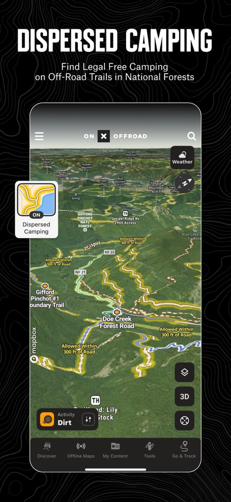
ユーザーは、この3Dマップ表示により、国立森林内の合法的かつ無料の分散キャンプ地を簡単に発見できます。
分散キャンプ地探索

このアプリは、詳細な土地所有者の情報を表示し、私有地の境界線を明確に視覚化することで、責任あるオフロード体験をサポートします。
私有地情報把握
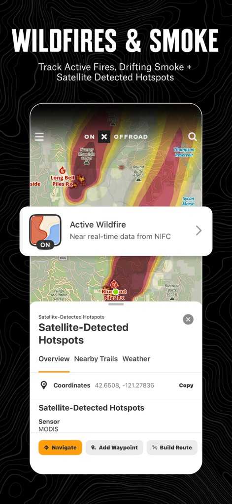
ユーザーは、活発な山火事のリアルタイムデータと衛星検出されたホットスポットの情報を視覚的に確認し、安全なルート選択に役立てることができます。
山火事・煙予測

この画面では、ユーザーが指定した範囲のオフラインマップをダウンロードでき、保存されたマップを一覧で管理する機能を提供します。
オフラインマップ管理
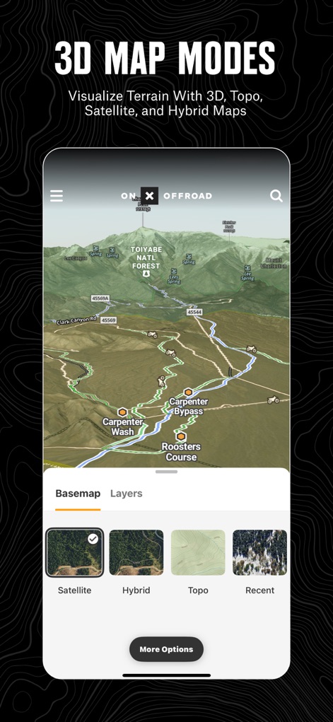
この機能は、詳細な3D地形表示を提供し、ユーザーは衛星、ハイブリッド、地形図といった複数のベースマップオプションから選択できます。
多様な3Dマップ

この画面では、最新の衛星画像を利用してトレイルの状況を確認でき、指定された期間選択により過去の画像との比較が可能です。
最新画像確認

このアプリは、国立公園や国有林などの公有地の境界を明確に表示し、燃料補給所やキャンプ場などのランドマーク情報を提供します。
公有地を探索

このスクリーンショットは、Apple CarPlayへのシームレスな連携を示しており、運転中にターンバイターンナビゲーションの指示を車両ディスプレイに表示できます。
CarPlayと連携
説明
Download
類似アプリ
似た機能とユーザー体験を持つアプリ

Detecht - Motorcycle App & GPS
Detecht Technologies AB

REVER - Motorcycle GPS & Rides
Rever, LLC

NYSSA Snowmobile Trails
Mapgears Inc.

Scenic Motorcycle Navigation
Applified Life Ltd.

Trails Offroad: Offline Maps
TRAILS OFFROAD LLC

Overland Bound One: Maps & GPS
Overland Bound Inc

Stegra.io - Motorcycle GPS
Stegraio AB

GoSnowmobiling NB
Mapgears Inc.

Lost Riders
Lost Riders, LLC
このページはアプリまたはその開発者の公式ページではなく、情報提供および論評を目的として作成された独立した編集出版物です。明示的に別段の記載がない限り、アプリおよびその開発者は、MWM、Apple、Google Play、アプリのパブリッシャー、またはアプリの開発者と提携、承認、後援、認可、またはその他の公式的な関係はなく、このページのいかなる内容も、アプリがMWMのサービスを使用して開発されたことを意味するものではありません。すべての商標、ロゴ、スクリーンショット、その他のコンテンツはそれぞれの所有者の財産です。