このページはアプリまたはその開発者の公式ページではなく、情報提供および論評を目的として作成された独立した編集出版物です。明示的に別段の記載がない限り、アプリおよびその開発者は、MWM、Apple、Google Play、アプリのパブリッシャー、またはアプリの開発者と提携、承認、後援、認可、またはその他の公式的な関係はなく、このページのいかなる内容も、アプリがMWMのサービスを使用して開発されたことを意味するものではありません。すべての商標、ロゴ、スクリーンショット、その他のコンテンツはそれぞれの所有者の財産です。

Hiking Maps - PeakVisor
冒険家のための究極のビジュアルツールキット。100万以上の山頂を特定し、最先端の3D地形モデリングでナビゲート。プロ仕様のGPSでハイキングやスキーのアドベンチャーを追跡。すべてオフラインで利用可能です。
ダウンロード
2M+ユーザー評価
評価数
62K+開発元
カテゴリ
Travel対応言語
14最新バージョン
5.73サイズ
150.6 MBリリース日
2016年12月21日最先端のツールであらゆる山頂を制覇
PeakVisorはスマートフォンを高精度ナビゲーションシステムに変え、拡張現実(AR)と3D地形モデリングを融合させて、あらゆる山の冒険をより豊かなものにします。
瞬時の山頂特定
カメラを向けるだけで、100万以上の山頂を即座に特定。圏外でも名前、標高、詳細な地形データを取得できます。
高精度3Dマップ
次世代の地形図で自信を持ってナビゲート。没入感のある3Dの世界で、トレイルの傾斜や地形の細部を可視化します。
よくある質問
について知っておくべきこと Hiking Maps - PeakVisor
PeakVisorとは何ですか?
PeakVisorは、最先端のピーク識別、3Dマップ、トレイル、アウトドアGPSトラッキングを提供する山のナビゲーションアプリです。ハイキング、スキー、登山などのアクティビティ向けに設計されており、詳細な3D山の体験を提供します。
PeakVisorはピーク識別に拡張現実を使用していますか?
はい、PeakVisorは拡張現実(AR)技術を使用しています。iPhoneのカメラビューに近くのピークの名前と標高を直接重ねて、リアルタイムで識別します。
PeakVisorはいくつの山を識別できますか?
PeakVisorは、世界中の100万以上の山、丘、ビュート、尖塔を識別できます。高度、地形的突出度、山脈、追加のWikipedia記事を含む詳細なプロファイルを提供します。
PeakVisorを使用してハイキングルートを計画できますか?
はい、PeakVisorは3Dマップと広大なトレイルネットワークを使用してハイキングルートの計画を可能にします。予想される距離、標高プロファイル、および推定完了時間を冒険のために評価するのに役立ちます。
PeakVisorはどのようなスキー機能を提供していますか?
PeakVisorは、山のロープウェイ、スキーリゾートのトレイル、バックカントリールートを詳細に示したスキー用の地形3Dマップを提供します。また、雪崩地形の識別のためのウィンターモードと斜面の傾斜オーバーレイも含まれています。
PeakVisorはケーブルカーと山小屋の情報を表示しますか?
はい、PeakVisorの3Dマップには、スケジュールとともにケーブルカーと山小屋が含まれています。この機能は、特にヨーロッパ地域での山の目標計画に役立ちます。
PeakVisorは私の野外活動を追跡できますか?
はい、PeakVisorはハイキング、スキー、マウンテンバイクなどの野外冒険のためのGPSトラッキングを提供します。3Dでルートを視覚化したり、距離や標高ゲインなどの統計を表示したり、GPXファイルをエクスポートしたりできます。
PeakVisorはインターネット接続なしでも機能しますか?
はい、PeakVisorのすべての機能はオフラインで機能します。ユーザーは、インターネット接続を必要とせずに完全な機能性を確保するために、アルプスなどの地域の地形図データをダウンロードできます。
PeakVisorのすべての機能に制限なくアクセスするにはどうすればよいですか?
ユーザーは、PeakVisor PROにサブスクライブすることで、PeakVisorのすべての機能に制限なくアクセスできます。このプレミアムサブスクリプションは、月額または年額で利用できます。
PeakVisorアプリには広告が表示されますか?
いいえ、PeakVisorアプリには広告は表示されません。アプリから生成されるすべての収益は、PeakVisor PROのユーザーサブスクリプションから得られます。
PeakVisorを使用して写真に山をタグ付けできますか?
はい、PeakVisorはAR技術を使用して写真に山をタグ付けすることを可能にします。ピークの名前と標高を画像に重ねて保存できます。
PeakVisorはルートのアニメーションフライオーバービデオを提供しますか?
はい、PeakVisorは「アニメーションフライオーバービデオ」機能を提供しています。ユーザーは、ルートの視覚的に素晴らしいアニメーションを開始して、他の人と共有したり、思い出を再訪したりできます。
以下のスクリーンショットと説明は、アプリの公式ストアリスティングから直接取得されたものであり、アプリ開発者の所有物です。
アプリストア
スクリーンショット
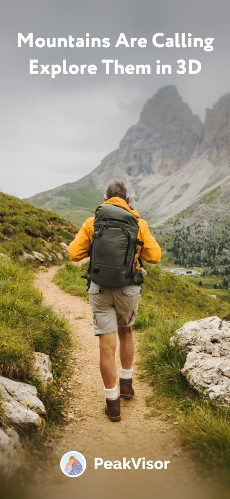
「山が呼んでいる、3Dで探索しよう」というテキストとともに山のトレイルを歩くハイカー
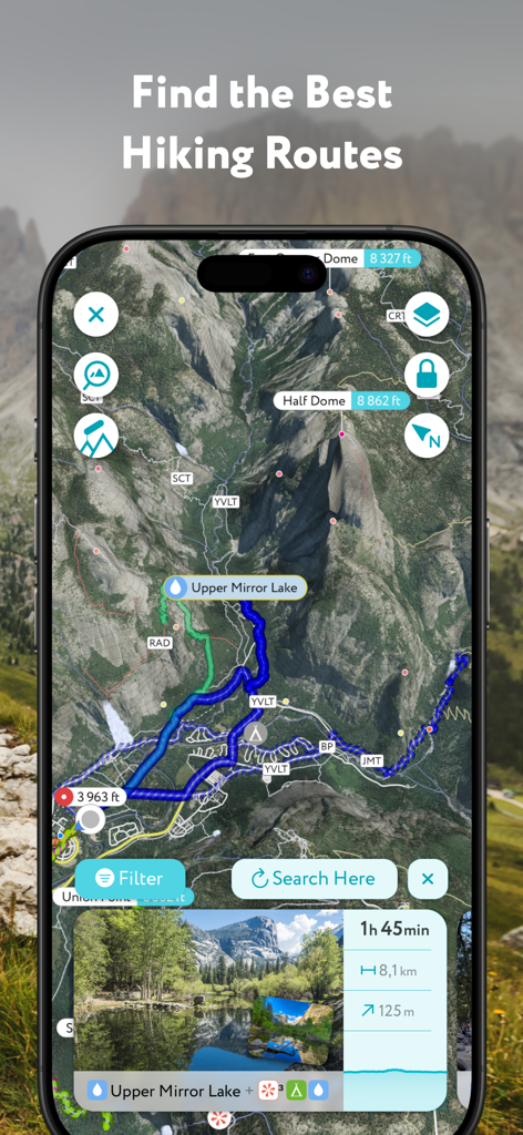
ハーフドームの3Dハイキングルートとトレイル情報を表示するPeakVisorモバイルアプリ
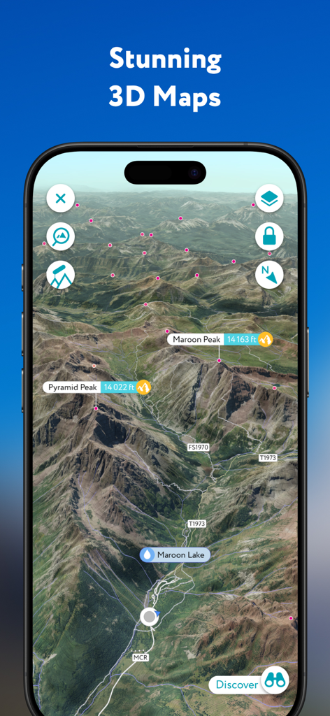
山頂名とハイキングトレイルがラベル付けされた高精度3D地形図を表示するPeakVisorアプリ
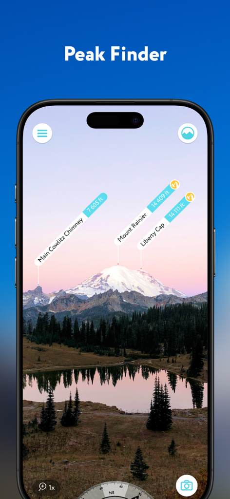
マウントレーニアなどの山頂を高度タグで特定するPeakVisorアプリの拡張現実インターフェース
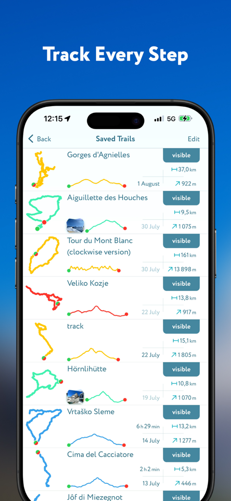
詳細なルートマップと標高プロファイルを含む、保存済みハイキングトレイルのリストを表示するPeakVisorアプリ画面
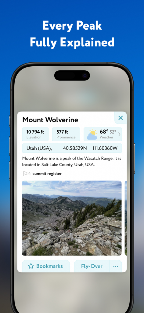
標高、プロミネンス、気象データを表示するPeakVisorアプリ内のマウント・ウルヴァリンの詳細プロファイル
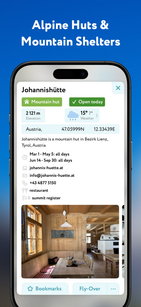
標高と気象情報を含む、オーストリアのヨハニスヒュッテ山小屋の詳細を表示するPeakVisorアプリ画面
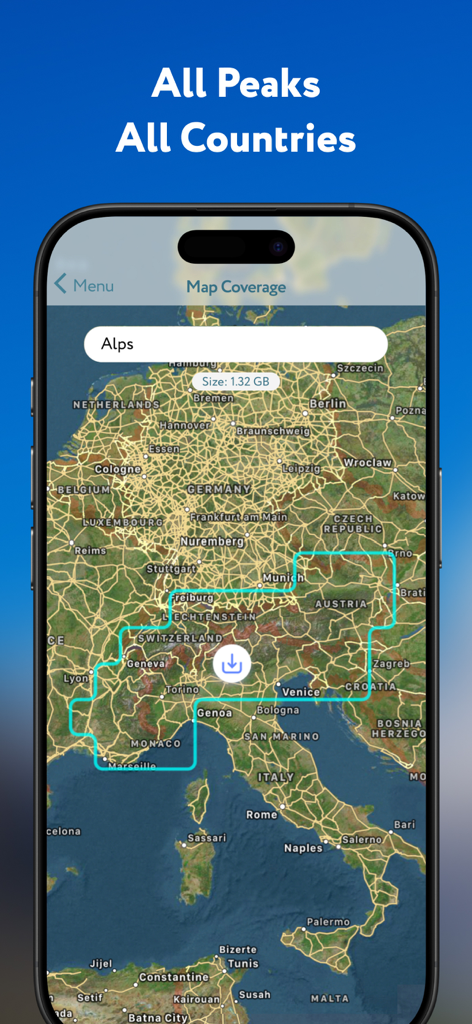
オフライン山岳データのダウンロードオプションが付いたアルプス山脈の地図を表示するPeakVisorアプリ画面
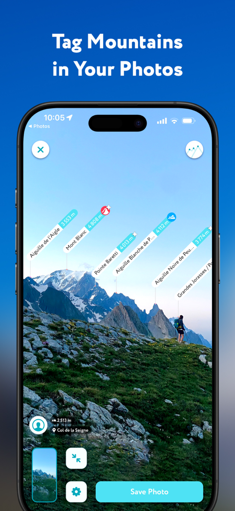
風景写真の中に名前と標高タグで特定された山頂を表示するPeakVisorアプリのインターフェース
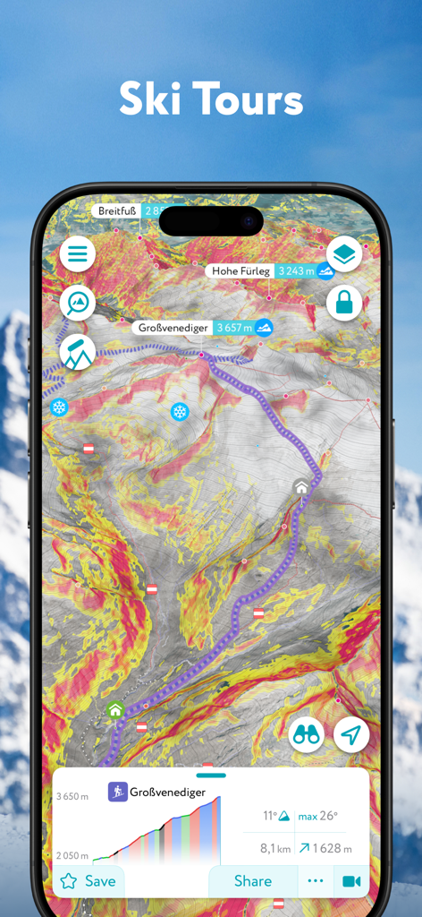
斜面の傾斜安全オーバーレイを伴うスキーツアーのルートを表示するPeakVisorアプリの3D地形図
説明
Download
類似アプリ
似た機能とユーザー体験を持つアプリ


このページはアプリまたはその開発者の公式ページではなく、情報提供および論評を目的として作成された独立した編集出版物です。明示的に別段の記載がない限り、アプリおよびその開発者は、MWM、Apple、Google Play、アプリのパブリッシャー、またはアプリの開発者と提携、承認、後援、認可、またはその他の公式的な関係はなく、このページのいかなる内容も、アプリがMWMのサービスを使用して開発されたことを意味するものではありません。すべての商標、ロゴ、スクリーンショット、その他のコンテンツはそれぞれの所有者の財産です。