このページはアプリまたはその開発者の公式ページではなく、情報提供および論評を目的として作成された独立した編集出版物です。明示的に別段の記載がない限り、アプリおよびその開発者は、MWM、Apple、Google Play、アプリのパブリッシャー、またはアプリの開発者と提携、承認、後援、認可、またはその他の公式的な関係はなく、このページのいかなる内容も、アプリがMWMのサービスを使用して開発されたことを意味するものではありません。すべての商標、ロゴ、スクリーンショット、その他のコンテンツはそれぞれの所有者の財産です。

TerraCam: GPS Satellite
このアプリは、ユーザーを単なる観光客から、地球のどこにいても現地の状況を瞬時に把握できる、秘密工作員のような存在に変える。位置情報付き写真撮影機能は、訪れた場所の単なる記録以上の、決定的な証拠を残す。
ダウンロード
1M+ユーザー評価
評価数
2.0K開発元
カテゴリ
Travel対応言語
17最新バージョン
1.1.0サイズ
102.1 MBリリース日
2025年9月16日旅行者、写真愛好家、アウトドア愛好家向けの多機能ツール
TerraCam: GPS Satellite アプリケーション分析
GPSカメラ
このアプリは、写真に位置情報、日付、時刻の詳細を自動的に付加する機能を提供します。
地球3Dマップ
このアプリは、インタラクティブな3Dビューで地球をナビゲートする機能を提供します。
有名な場所
ユーザーは、世界中のランドマークや観光スポットを発見し、探索することができます。
交通マップ
本ツールは、リアルタイムの交通状況に関する最新情報を提供し、ユーザーの移動計画を支援します。
360度ビュー
ユーザーは、パノラマ画像を通じてより広範な視点で場所を探索することができます。
ライブカメラ
本ツールは、世界中の特定の公共カメラからのライブ映像を表示することを可能にします。
コンパス
このアプリは、正確な方向を容易に特定するためのデジタルコンパス機能を提供します。
大気質
本ツールは、ユーザーが瞬時に現地の空気の状態を確認することを可能にします。
よくある質問
について知っておくべきこと TerraCam: GPS Satellite
What is TerraCam: GPS Satellite?
TerraCam: GPS Satellite is an application that combines location tagging with map and travel tools. It allows users to capture photos with GPS details, explore interactive maps, check traffic, and access navigation features.
What are the main features of TerraCam: GPS Satellite?
TerraCam: GPS Satellite offers GPS Camera, Live Cameras, 360 View, Earth 3D Map, Traffic Map, Famous Places, Compass, Air Quality, and World Clock. These provide comprehensive navigation and exploration tools.
Can TerraCam: GPS Satellite capture photos with location data?
Yes, TerraCam: GPS Satellite includes a GPS Camera feature. It captures photos embedded with location, date, and time details, ensuring your memories are accurately geotagged.
Does TerraCam: GPS Satellite offer a 3D view of Earth?
Yes, TerraCam: GPS Satellite features an Earth 3D Map. This allows users to navigate the globe with interactive three-dimensional views, enhancing exploration.
How can I check traffic conditions using TerraCam: GPS Satellite?
TerraCam: GPS Satellite provides a Traffic Map feature to keep you updated. It displays real-time traffic conditions, assisting you with navigation and travel planning.
Does TerraCam: GPS Satellite include a compass?
Yes, TerraCam: GPS Satellite integrates a Compass feature. This tool provides accurate directions, making it easy to orient yourself during travel or exploration.
Where can I find the Privacy Policy for TerraCam: GPS Satellite?
The Privacy Policy for TerraCam: GPS Satellite is available at https://sites.google.com/view/terra-cam-gps/privacy-policy. This document outlines how the app handles user data.
Can TerraCam: GPS Satellite show live camera feeds?
Yes, TerraCam: GPS Satellite includes a Live Cameras feature. It allows users to view selected public cameras from various locations around the world.
What types of map views are available in TerraCam: GPS Satellite?
TerraCam: GPS Satellite offers various map views, including Default, Terrain, Satellite, and Night. Users can select their preferred map style for navigation and exploration.
以下のスクリーンショットと説明は、アプリの公式ストアリスティングから直接取得されたものであり、アプリ開発者の所有物です。
アプリストア
スクリーンショット

このホーム画面では、ライブトラフィックカメラのストリームでリアルタイムの交通状況が確認でき、「Camera 3D」や「Earth 3D」といった主要機能へのクイックアクセスボタンが配置されています。
ライブ地球マップ
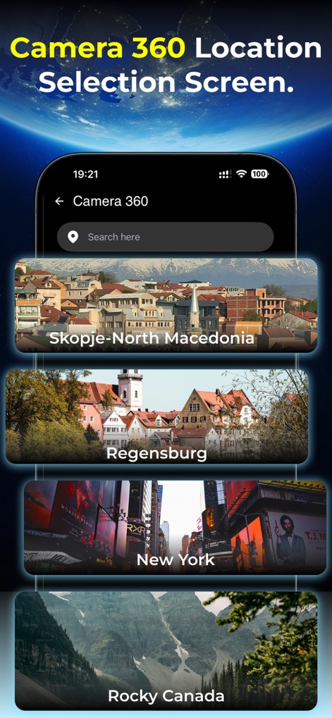
ユーザーは、検索バーを使って特定の場所を検索するか、スコピエやニューヨークなどの視覚的なサムネイル付きの世界の様々な場所から選択して360度カメラ機能を利用できます。
360度カメラ選択
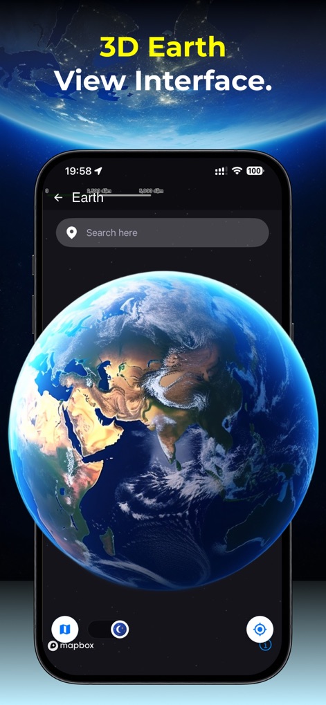
この画面では、インタラクティブな3D地球儀を探索でき、上部の検索バーを利用して特定の場所を簡単に見つけることができます。
3D地球表示
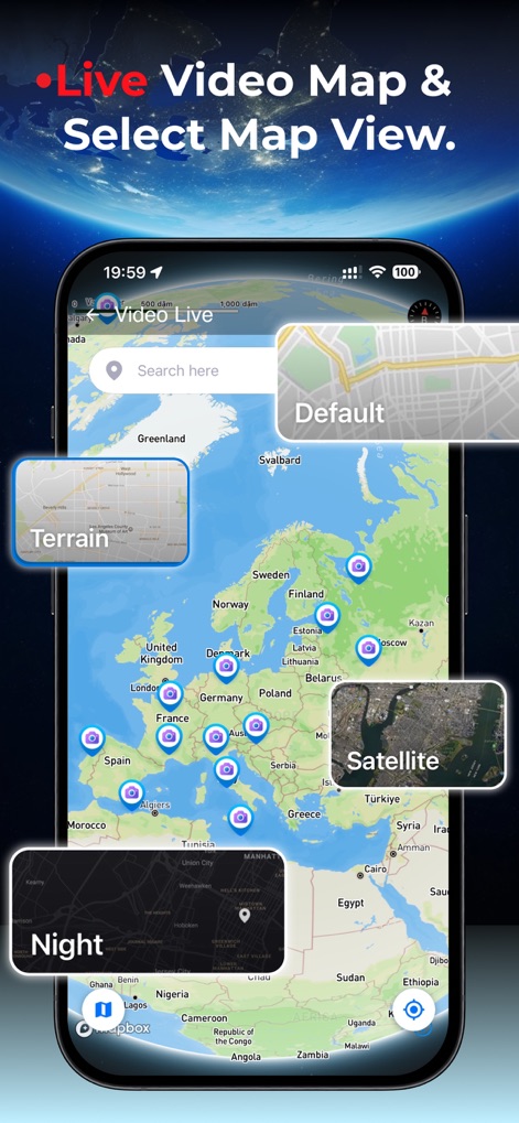
このライブビデオマップでは、ヨーロッパ全域に配置された多数のライブカメラの場所が視覚化されており、「Satellite」や「Night」などの多様なマップ表示オプションを選択できます。
ライブビデオマップ
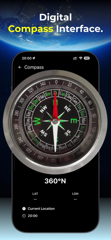
このインターフェースは、正確な方角を示すデジタルコンパスを大きく表示し、ユーザーは現在の緯度と経度の詳細な地理座標を確認できます。
デジタルコンパス
説明
Download
類似アプリ
似た機能とユーザー体験を持つアプリ

Realtime Altimeter
Zhenlai Xia

Travel Camera & Compass
Ha Nguyen

compass-latitude and longitude
美霞 熊

Compass ×
DOUBLE U s.r.o.

GPS Altitude-海拔表
祥琦 孔

Compass: GPS & Altimeter
Shanghai BRC Internet Technology Co., Ltd.

Compass - GPS positioning
嘉 罗

Compass360X-GPS Speedometer
卫豪 吴

指南针-GPS经纬度海拔定位
Chongqing Xinzhi Space Technology Co., Ltd.
このページはアプリまたはその開発者の公式ページではなく、情報提供および論評を目的として作成された独立した編集出版物です。明示的に別段の記載がない限り、アプリおよびその開発者は、MWM、Apple、Google Play、アプリのパブリッシャー、またはアプリの開発者と提携、承認、後援、認可、またはその他の公式的な関係はなく、このページのいかなる内容も、アプリがMWMのサービスを使用して開発されたことを意味するものではありません。すべての商標、ロゴ、スクリーンショット、その他のコンテンツはそれぞれの所有者の財産です。