このページはアプリまたはその開発者の公式ページではなく、情報提供および論評を目的として作成された独立した編集出版物です。明示的に別段の記載がない限り、アプリおよびその開発者は、MWM、Apple、Google Play、アプリのパブリッシャー、またはアプリの開発者と提携、承認、後援、認可、またはその他の公式的な関係はなく、このページのいかなる内容も、アプリがMWMのサービスを使用して開発されたことを意味するものではありません。すべての商標、ロゴ、スクリーンショット、その他のコンテンツはそれぞれの所有者の財産です。

Ventusky: Weather & Live Radar
20以上のグローバルモデルと高精細レーダーの融合により、計画立案を強化します。広告なし、プライバシー重視のインタラクティブな3D地球儀で、局所的な精度を体験してください。
ダウンロード
1M+ユーザー評価
評価数
76K+開発元
カテゴリ
Weather対応言語
39最新バージョン
50.3サイズ
68.4 MBリリース日
2017年9月12日あらゆる冒険にプロフェッショナルグレードの精度を
完全な環境認識を求める人々のために設計された、20以上のグローバル気象モデルと高解像度視覚化の融合を体験してください。
マルチモデル予測融合
ECMWFやGFSのような世界の主要モデルを局所的な解像度で比較し、データ変動によって計画が損なわれることがないようにします。
80以上の高密度マップ
3D風アニメーション、CAPE指数、高度層別レイヤーで詳細なデータレイヤーに深く入り込み、パイロット、船乗り、ドローン操縦者に最適です。
よくある質問
について知っておくべきこと Ventusky: Weather & Live Radar
Ventusky: Weather Maps & Radar とは何ですか?
Ventuskyは、20以上のグローバルモデル、ライブレーダー、衛星、40,000以上のウェブカメラを統合したオールインワンの天気アプリです。ジョギングから大西洋横断フライトまで、あらゆる計画に業界をリードする精度を提供します。
Ventusky は超局地的な天気予報を提供していますか?
はい、Ventusky は時間解像度で超局地的な14日間の天気予報を提供します。この機能は、屋外活動の計画や突然の天候の変化を避けるために重要な、正確なアップデートを提供します。
Ventusky ではいくつの天気図が利用可能ですか?
Ventusky では80以上の天気図を提供しています。これらの図は、気温、降水量、突風、大気質など、さまざまな現象を包括的に表示します。
ユーザーは Ventusky アプリでハリケーンを追跡できますか?
はい、Ventusky はハリケーンと嵐の追跡機能を備えています。複数のモデルからの進路を比較できるため、熱帯低気圧の際の準備と安全を確保できます。
Ventusky にはライブレーダーと雷検知が含まれていますか?
はい、Ventusky はライブレーダーと雷検知を統合しています。この機能は毎分ごとの予報を提供し、嵐の活動と雷の発生をリアルタイムで監視できます。
Ventusky は予測にどの気象モデルを使用していますか?
Ventusky は、ECMWF、GFS、ドイツのICONモデルを含む20以上の高度な数値気象予測システムからのデータを融合しています。あらゆる場所で最も正確なモデルを自動的に選択します。
Ventusky は異なる高度での風のパターンをアニメーション化できますか?
はい、Ventusky は2つの異なる高度でのデュアル風アニメーションを提供します。プロフェッショナル向けには、フライト経路の最適化のために16の高度(0m~13km)でのパターンをアニメーション化する航空風レイヤーを提供します。
Ventusky は大気質に関する情報を提供していますか?
はい、Ventusky は広範な大気質情報を提供しています。PM2.5、NO2、オゾンレベルなどのためにSILAMモデルデータを使用しており、ユーザーが活動を計画し、健康を監視するのに役立ちます。
Ventusky はホーム画面とロック画面のウィジェットをサポートしていますか?
はい、Ventusky はロック画面とホーム画面のウィジェットをサポートしています。これらのウィジェットは、予報、ウェブカメラ、またはレーダー情報を表示し、天気データへの即時アクセスを提供します。
Ventusky アプリは広告やトラッキングから完全に無料ですか?
はい、Ventusky アプリは広告やトラッキングスクリプトが完全に無料です。これにより、プライベートで中断のないユーザーエクスペリエンスが保証されます。
以下のスクリーンショットと説明は、アプリの公式ストアリスティングから直接取得されたものであり、アプリ開発者の所有物です。
アプリストア
スクリーンショット
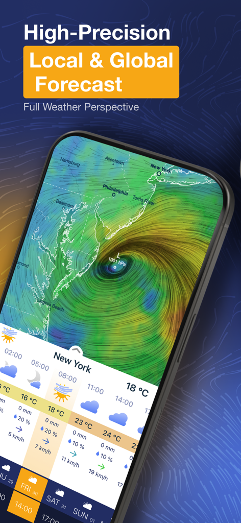
Ventuskyアプリが米国東海岸の高精度な局所天気予報とインタラクティブな風の地図を表示しています。
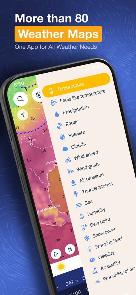
スマートフォン画面にVentuskyアプリが表示されており、サイドメニューには気温、風、降水量などの様々な気象マップレイヤーがヒートマップ上にリストされています。
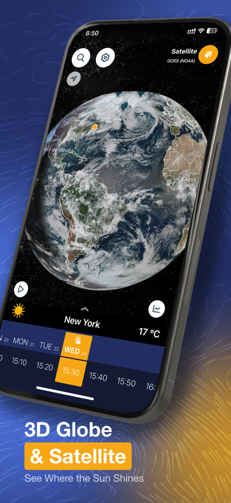
スマートフォン画面にVentuskyアプリが表示されており、3Dインタラクティブ地球儀と衛星気象画像が表示されています。
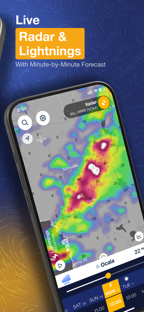
Ventuskyアプリのインターフェースが、高解像度のインタラクティブマップ上にライブ気象レーダーと落雷データを示しています。
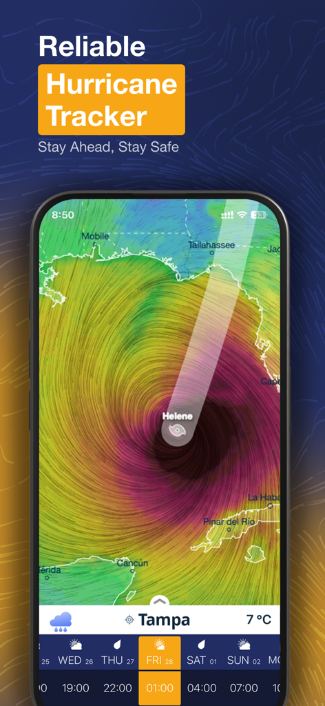
Ventuskyアプリのハリケーントラッカーインターフェースが、メキシコ湾とフロリダ海岸上空のハリケーン「ヘレン」を表示しています。
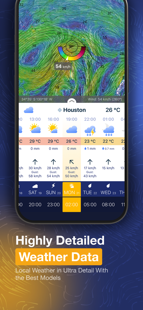
Ventuskyアプリのヒューストン向け詳細天気予報と風の地図インターフェース。
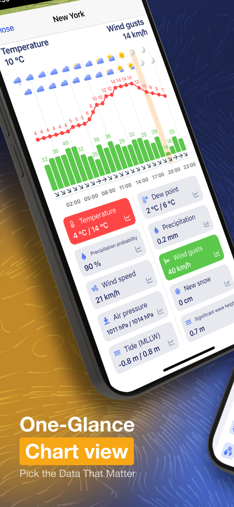
Ventuskyモバイルアプリがニューヨークの詳細な天気図とデータタイルを表示しています。
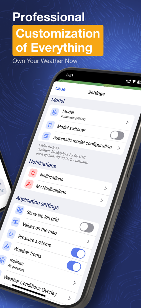
Ventuskyアプリの設定画面で、気象モデルとマップレイヤーのプロフェッショナルなカスタマイズオプションが表示されています。
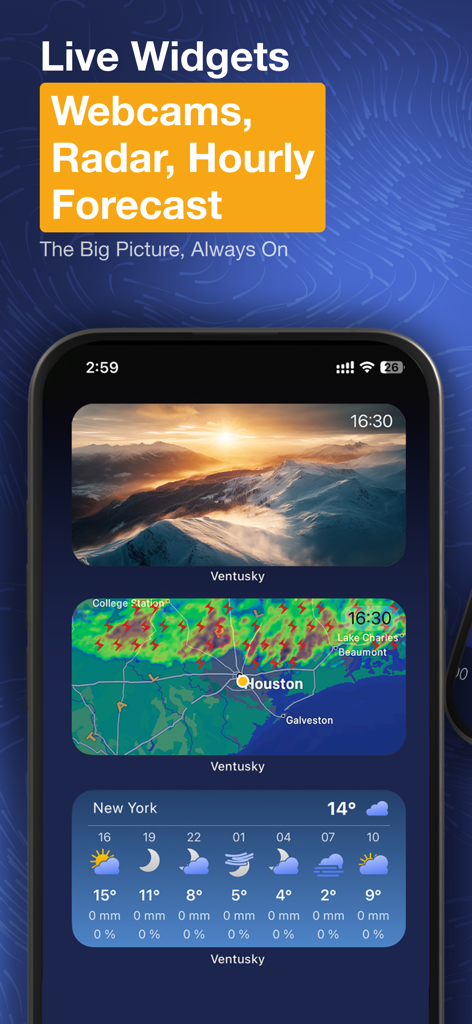
Ventusky天気アプリが、iPhone上の山岳ウェブカメラ、ライブレーダーマップ、時間予報のホーム画面ウィジェットを展示しています。
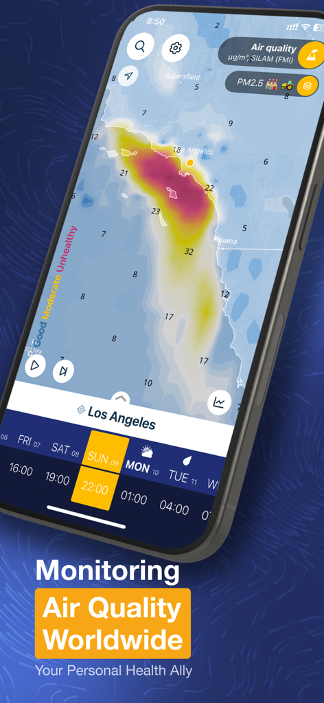
Ventuskyモバイルアプリのスクリーンショットで、PM2.5データを含むロサンゼルスの詳細な大気質ヒートマップが表示されています。
説明
Download
類似アプリ
似た機能とユーザー体験を持つアプリ

墨迹天气-MojiWeather
Beijing MojiFengyun Technology Co.,Ltd.

Windy.com
Windyty, SE

天气通
Weibo Internet Technology (China) Co.Ltd.

Zoom Earth - Weather Forecast
Neave Interactive Limited

实时天气-40日精准天气实时预报
犇 牛

MyRadar Accurate Weather Radar
Aviation Data Systems, Inc

FOX Weather: Daily Forecasts
Fox News Network, LLC

2345天气王-天气和空气质量查询小组件
Shanghai 2345 Network Technology Co., Ltd.

Weather & Widget - Weawow
weawow Inc.
このページはアプリまたはその開発者の公式ページではなく、情報提供および論評を目的として作成された独立した編集出版物です。明示的に別段の記載がない限り、アプリおよびその開発者は、MWM、Apple、Google Play、アプリのパブリッシャー、またはアプリの開発者と提携、承認、後援、認可、またはその他の公式的な関係はなく、このページのいかなる内容も、アプリがMWMのサービスを使用して開発されたことを意味するものではありません。すべての商標、ロゴ、スクリーンショット、その他のコンテンツはそれぞれの所有者の財産です。