このページはアプリまたはその開発者の公式ページではなく、情報提供および論評を目的として作成された独立した編集出版物です。明示的に別段の記載がない限り、アプリおよびその開発者は、MWM、Apple、Google Play、アプリのパブリッシャー、またはアプリの開発者と提携、承認、後援、認可、またはその他の公式的な関係はなく、このページのいかなる内容も、アプリがMWMのサービスを使用して開発されたことを意味するものではありません。すべての商標、ロゴ、スクリーンショット、その他のコンテンツはそれぞれの所有者の財産です。

Zoom Earth - Weather Forecast
驚くほどインタラクティブな地図とライブ衛星画像で、プロの気象学の力を体験してください。主要なハリケーンの追跡から山火事の監視まで、10分ごとに更新されるデータで情報を入手し、準備を整えましょう。
ダウンロード
2M+ユーザー評価
評価数
122K+開発元
カテゴリ
Weather対応言語
14最新バージョン
5.0.1サイズ
52.3 MBリリース日
2023年6月27日変化する世界のためのビジュアルインテリジェンス
最も高度なインタラクティブ天気図を体験し、高解像度衛星画像とプロ仕様の追跡ツールを組み合わせて、自然現象の一歩先を行きましょう。
ニアリアルタイム衛星フィード
NOAAおよびNASAの衛星からのHD画像が10分ごとに更新され、グローバルな気象パターンが進化する様子を観察し、生データを直接画面に表示します。
精密ハザード追跡
気象専門家や緊急対応者が使用するのと同じデータで、ハリケーン、山火事、激しい嵐を監視し、自宅と家族を保護しましょう。
よくある質問
について知っておくべきこと Zoom Earth - Weather Forecast
Zoom Earth - Weather Forecast とは何ですか?
Zoom Earth は、インタラクティブな天気図とリアルタイムのハリケーン追跡ツールで、世界中の雨、風、気温、気圧などの予報を提供します。
Zoom Earth はリアルタイムの天気情報を提供しますか?
はい、Zoom Earth は 10 分ごとに更新されるほぼリアルタイムの衛星画像と、地上設置型ドップラーレーダーによるリアルタイムの降雨/降雪検出(ナウキャスティング)を提供します。
Zoom Earth はハリケーンをリアルタイムで追跡できますか?
はい、Zoom Earth はハリケーンの発生からカテゴリー 5 までリアルタイムで追跡します。NHC、JTWC、NRL、IBTrACS からの最新データを使用して更新されます。
Zoom Earth は山火事も表示しますか?
はい、Zoom Earth は NASA FIRMS のデータで毎日更新される、活動中の火災と熱点のオーバーレイで山火事を監視します。山火事の煙の動きも表示されます。
Zoom Earth で利用できる天気予報マップは何ですか?
Zoom Earth は、降水量、風速、突風、気温、「体感」気温、相対湿度、露点、気圧の予報マップを提供します。
Zoom Earth PRO サブスクリプションはどのように機能しますか?
Zoom Earth PRO は、自動更新サブスクリプションを通じて追加機能を提供します。支払いは App Store アカウントに請求され、24 時間前までにオフにされない限り自動的に更新されます。
Zoom Earth で設定をカスタマイズできますか?
はい、Zoom Earth では、包括的な設定を通じて、温度単位、風の単位、タイムゾーン、アニメーション スタイルをカスタマイズできます。
Zoom Earth の衛星画像はどのくらいの頻度で更新されますか?
ライブ衛星画像は、衛星ソースによって異なりますが、10 分または 15 分ごとに更新されます。HD 衛星画像は 1 日に 2 回更新されます。
Zoom Earth には雨レーダーマップが含まれていますか?
はい、Zoom Earth には、地上設置型ドップラーレーダーによって検出されたリアルタイムの雨と雪を表示する気象レーダーマップがあります。即時の短期天気予報を提供します。
Zoom Earth で風速情報を確認できますか?
はい、Zoom Earth は、表面風の平均速度と方向を示す詳細な風速予報マップと、突風の予報情報を提供します。
以下のスクリーンショットと説明は、アプリの公式ストアリスティングから直接取得されたものであり、アプリ開発者の所有物です。
アプリストア
スクリーンショット
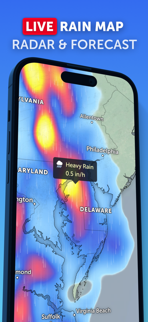
Zoom Earthアプリに、東海岸のライブ降雨マップ、レーダー予報、大雨警報が表示されている様子。
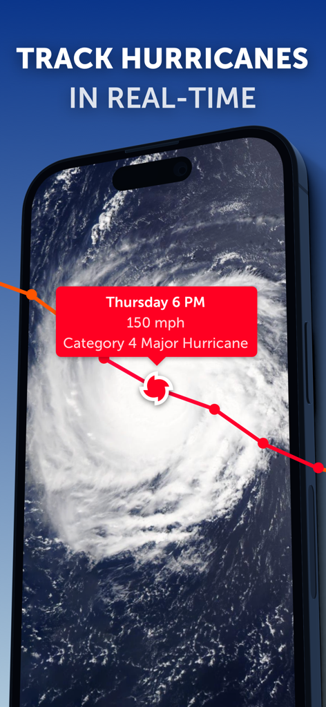
Zoom Earthアプリのインターフェイスに、カテゴリー4のハリケーンのリアルタイム衛星追跡とデータが表示されている様子。
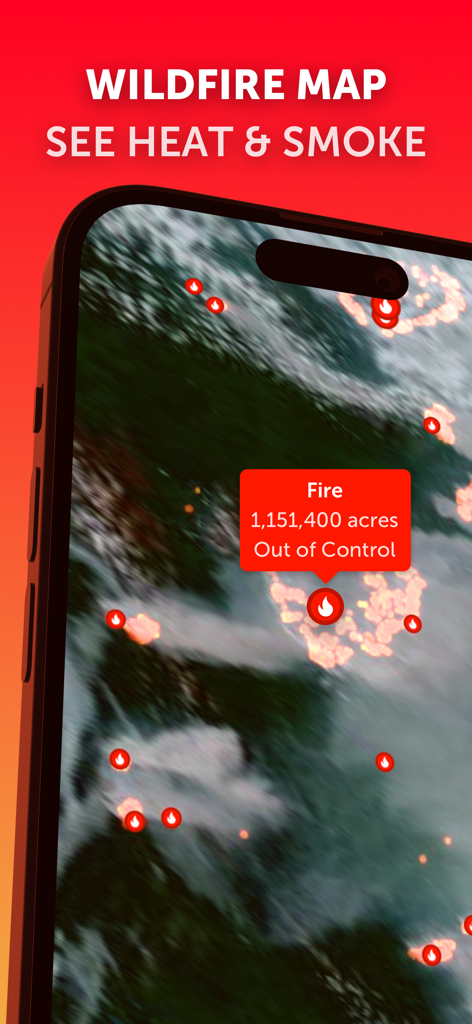
Zoom Earthアプリに、リアルタイムの山火事マップ、ホットスポット、制御不能な火災データが表示されている様子。
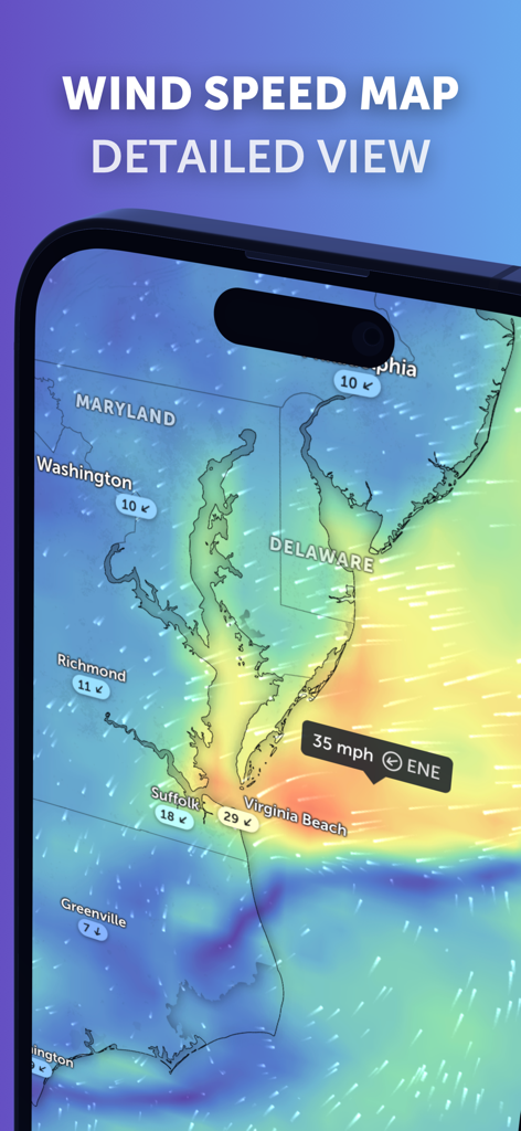
Zoom Earthモバイルアプリのインターフェイスで、メリーランド州とバージニア州の現在の状況を示す詳細な風速予報マップ。
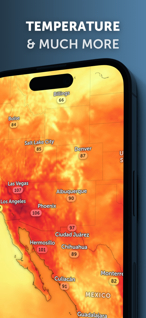
Zoom Earthアプリに、スマートフォンの北米の温度ヒートマップが表示されている様子。
説明
Download
類似アプリ
似た機能とユーザー体験を持つアプリ

墨迹天气-MojiWeather
Beijing MojiFengyun Technology Co.,Ltd.

Windy.com
Windyty, SE

天气通
Weibo Internet Technology (China) Co.Ltd.

实时天气-40日精准天气实时预报
犇 牛

MyRadar Accurate Weather Radar
Aviation Data Systems, Inc

Ventusky: Weather & Live Radar
Ventusky s.r.o.

FOX Weather: Daily Forecasts
Fox News Network, LLC

2345天气王-天气和空气质量查询小组件
Shanghai 2345 Network Technology Co., Ltd.

Weather & Widget - Weawow
weawow Inc.
このページはアプリまたはその開発者の公式ページではなく、情報提供および論評を目的として作成された独立した編集出版物です。明示的に別段の記載がない限り、アプリおよびその開発者は、MWM、Apple、Google Play、アプリのパブリッシャー、またはアプリの開発者と提携、承認、後援、認可、またはその他の公式的な関係はなく、このページのいかなる内容も、アプリがMWMのサービスを使用して開発されたことを意味するものではありません。すべての商標、ロゴ、スクリーンショット、その他のコンテンツはそれぞれの所有者の財産です。