이 페이지는 앱이나 개발자의 공식 페이지가 아니며, 정보 제공 및 논평을 목적으로 작성된 독립 편집 간행물입니다. 명시적으로 달리 언급되지 않는 한, 해당 앱이나 개발자는 MWM, Apple, Google Play, 앱 퍼블리셔 또는 앱 개발자와 제휴, 보증, 후원, 승인 또는 공식적으로 연결되어 있지 않으며, 이 페이지의 어떤 내용도 해당 앱이 MWM의 서비스를 사용하여 개발되었음을 의미하지 않습니다. 모든 상표, 로고, 스크린샷 및 기타 콘텐츠는 해당 소유자의 자산입니다.
Agro Measure Map Pro
iPad 또는 iPhone을 전문가 수준의 GIS 도구로 바꿔보세요. 놀라운 정확도로 농장 면적을 계산하고, 파종 격자를 생성하며, 완충 구역을 만들어 운영을 최적화하고 ROI를 극대화하세요.
주요 수치
다운로드
28K+
사용자 평점
4.6/5
총 평가 수
0
개발사
Blue Blink One, SL
카테고리
Utilities
지원 언어
10
최신 버전
8.10.5
크기
239.1 MB
출시일
2015년 1월 29일
기능
전문 토지 관리를 위한 정밀 매핑
농부, 엔지니어 및 토지 개발자를 위해 설계된 놀라운 측정 및 고급 계획 도구로 농장 운영을 간소화하세요.
전문가 수준의 정확도
지구 곡률 보정을 통해 면적과 둘레를 계산하여 씨앗, 비료 및 울타리 예산에 대한 정확한 정밀도를 보장합니다.
스마트 격자 및 완충 계획
자동 파종 격자 생성기로 수확량을 최적화하고 정확한 살포 완충 구역을 만들어 화학 물질 낭비와 비용을 줄입니다.
다음 스크린샷과 설명은 앱의 공식 스토어 목록에서 직접 가져온 것이며 앱 개발자의 자산입니다.
앱 스토어
스크린샷
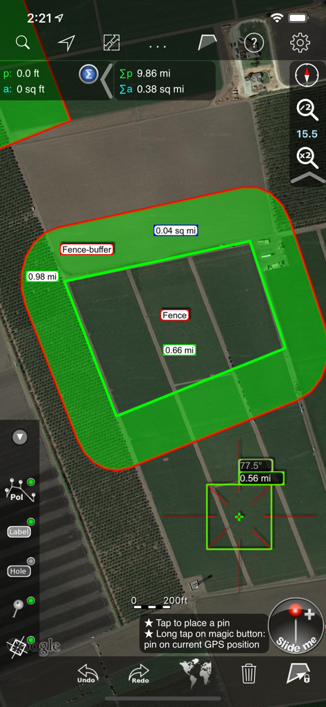
Agro Measure Map Pro 인터페이스가 계산된 울타리 완충 구역 및 농장 측정이 있는 위성 농장 이미지를 표시합니다.
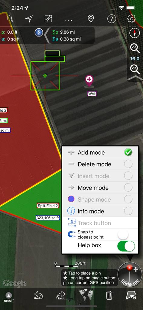
Agro Measure Map Pro 인터페이스가 위성 지도에서 농장 측정 도구 및 편집 모드 선택을 보여줍니다.
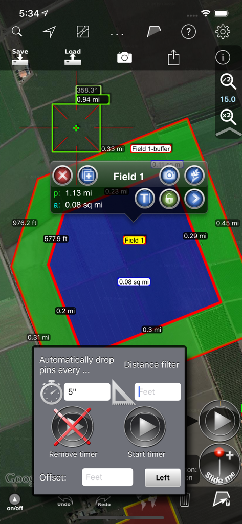
농장 측정 및 자동 GPS 추적 옵션이 있는 Agro Measure Map Pro 인터페이스
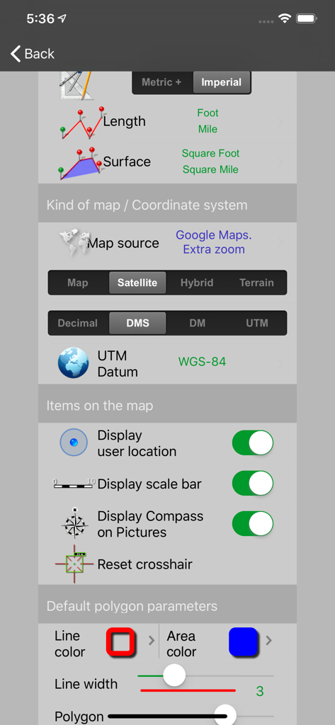
단위, 지도 소스, 좌표계 및 디스플레이 옵션에 대한 구성을 보여주는 Agro Measure Map Pro의 설정 화면
설명
Agro Measure Map Pro lets you quickly and easily measure multiple distances, perimeters and areas with laser sharp precision! It even takes into account the curvature of the earth’s surface. Use it for small areas or large, then share your findings via iTunes or email. Click “...More” to learn why you should download this App today!
Calculate surface areas, fields, plots, forest areas or dimensions for fencing, spraying, plowing or anything you need for field work without having to go to the spot to take measurements. Only one finger to calculate with astonishing accuracy all these measurements over satellite images.
That’s what Agro Measure Map Pro is for, to put a powerful, portable measuring tool right in the palm of your hand. Your iPhone, iPod touch or iPad can now provide you with totally precise measurements of any distance, from as small as one tenth of a meter to as big as thousands of kilometers or miles.
Just one "magic" button for all the operations to easily place points without loosing its professional accuracy.
Some features you get in Measure Map Pro:
* Attractive, smooth, easy navigation and use
* For iPhone and iPad
* Retina display
* Apple or G00GLE Maps with extra zoom level.
* Displays Maps View: Map, Satellite, Hybrid and Terrain.
* More maps with extra zoom level through in-app purchase: Bing, Yahoo Maps, and ArcGIS. And MapQuest, Open Street, Open Cycle, World Street and more in the future
* Operations: Add, delete intermediate pins, insert between pins, move pins, get info.
* Circles and rectangles
* Multiple areas and routes on screen
* Display of altitude above sea level, azimuth and angle
* Undo and redo operations as needed
* AirPrint and iCloud support
* Calculates azimuth or bearing
* Search for current location, text (villages, places of interest, etc.) or an area or route
* Lots of longitude and surface measurement units
* Intermediate distances between pins can be displayed
* Ability to select color, thickness and transparency
* Working format: Measure Map, KMZ, KML (G00GLE Earth), CSV (Excel), GPX, Image (PNG) and PDF
* Export and import of surfaces and routes via e-mail, iTunes, AirDrop and Dropbox.
* Save to photo album
* Download surfaces and routes from the Internet.
* Apple Pencil drawing mode (with iPad Pro)
Differences with the non-pro version:
* Calculates multiple areas and routes simultaneously
* Ability to create inner polygons as "holes".
* Drawing of shapes: circle and rectangle.
* More maps with extra zoom level through in-app purchase
* Calculates azimuth or bearing
* Displays altitude above sea level, azimuth and angle.
* Imports KML, KMZ and GPX format files besides exporting them.
* Track mode: drops pins on current GPS position at regular intervals.
(Continued use of GPS running in the background can dramatically decrease battery life)
* Coordinate system DM
* Apple Pencil drawing mode (with iPad Pro)
* Autosave
Agro exclusive Features:
- A Buffer area generator. Enter a distance and Agro M.M. Pro will create a buffer area around any polygon.
- A Grid generator to calculate the number of seedlings and best position to maximise it.
- Split and join polygons for rearrangement of fields and crops.
- More to come with your suggestions. Please send them to info@globaldpi.com.
If precise measurements are important to you, this is the app you need. You won’t find one that is better, more accurate and easier to use.
Terms of use: https://www.apple.com/legal/internet-services/itunes/dev/stdeula/
이 페이지는 앱이나 개발자의 공식 페이지가 아니며, 정보 제공 및 논평을 목적으로 작성된 독립 편집 간행물입니다. 명시적으로 달리 언급되지 않는 한, 해당 앱이나 개발자는 MWM, Apple, Google Play, 앱 퍼블리셔 또는 앱 개발자와 제휴, 보증, 후원, 승인 또는 공식적으로 연결되어 있지 않으며, 이 페이지의 어떤 내용도 해당 앱이 MWM의 서비스를 사용하여 개발되었음을 의미하지 않습니다. 모든 상표, 로고, 스크린샷 및 기타 콘텐츠는 해당 소유자의 자산입니다.