이 페이지는 앱이나 개발자의 공식 페이지가 아니며, 정보 제공 및 논평을 목적으로 작성된 독립 편집 간행물입니다. 명시적으로 달리 언급되지 않는 한, 해당 앱이나 개발자는 MWM, Apple, Google Play, 앱 퍼블리셔 또는 앱 개발자와 제휴, 보증, 후원, 승인 또는 공식적으로 연결되어 있지 않으며, 이 페이지의 어떤 내용도 해당 앱이 MWM의 서비스를 사용하여 개발되었음을 의미하지 않습니다. 모든 상표, 로고, 스크린샷 및 기타 콘텐츠는 해당 소유자의 자산입니다.

Altimeter Pro: Compass, GPS
등산객, 등반가 및 야외 활동 애호가를 위한 전문가용 도구 키트입니다. 고도를 추적하고, 기압을 모니터링하며, 주머니나 Apple Watch에서 바로 데이터가 풍부한 사진으로 정상 등반 성공을 공유하세요.
다운로드
118K+사용자 평점
총 평가 수
500개발사
카테고리
Navigation지원 언어
8최신 버전
2.1크기
89.7 MB출시일
2017년 5월 29일정밀함으로 모든 지형을 마스터하세요
등산, 하이킹, 탐험을 위한 궁극적인 올인원 동반자로서, 실시간 고도 및 위치 데이터를 손목과 손바닥에 바로 전달합니다.
실시간 고도 및 기압
고도 증가 및 기압을 즉시 모니터링하여 날씨 변화를 예측하고 고고도 모험 중 안전을 유지하세요.
인증된 성과 공유
고도, GPS 좌표 및 나침반 방향이 자동으로 오버레이된 정상 등반 순간을 캡처하여 성과 증명을 공유하세요.
자주 묻는 질문
에 대해 알아야 할 모든 것 Altimeter Pro: Compass, GPS
Altimeter Pro: Compass, GPS는 무엇인가요?
Altimeter Pro: Compass, GPS는 여행이나 하이킹 중에 사용자의 위치, 고도, 방향, 지리 좌표, 주소 및 기압을 즉시 파악할 수 있게 해주는 애플리케이션입니다.
Altimeter Pro는 일반 모드에서 어떤 정보를 제공하나요?
일반 모드에서 Altimeter Pro는 현재 고도, 기압, 위도 및 경도 좌표, 주소, 이동 속도, 상세 나침반을 통한 방향을 제공합니다.
Altimeter Pro가 이동 중에 내 위치와 고도를 추적할 수 있나요?
네, Altimeter Pro에는 "지도에서 트랙 모드" 기능이 있어 이동 중에 위치와 고도, 압력, 좌표, 주소, 속도, 방향의 변화를 즉시 추적합니다.
Altimeter Pro는 고도와 위치 좌표를 어떻게 측정하나요?
Altimeter Pro는 기기의 GPS 신호를 사용하여 고도와 위치 좌표를 계산합니다. 이러한 측정의 정확도는 GPS 신호 품질에 따라 달라질 수 있습니다.
Altimeter Pro가 특정 위치의 고도를 저장할 수 있나요?
네, Altimeter Pro의 마커 모드를 사용하면 사용자는 지도에서 직접 선택한 위치의 고도 및 좌표 정보를 탐색, 표시 및 저장할 수 있습니다.
Altimeter Pro에서 위치 데이터가 포함된 사진을 공유할 수 있나요?
네, Altimeter Pro의 공유 모드를 사용하면 사용자는 고도, 압력, 좌표 및 주소 정보가 포함된 사진을 공유할 수 있습니다. 촬영 각도에 따라 나침반 방향도 포함됩니다.
Altimeter Pro는 Apple Watch와 호환되나요?
네, 사용자는 Altimeter Pro를 사용하여 Apple Watch에서 직접 고도 및 위치 정보에 액세스할 수 있습니다.
Altimeter Pro에서 측정 단위를 사용자 정의할 수 있나요?
네, Altimeter Pro를 사용하면 고도 단위를 미터 또는 피트, 좌표 형식을 변경하고, 속도를 km/h 또는 mph로, 기압계 단위를 psi 또는 kPA로 변경할 수 있습니다.
Altimeter Pro가 대기압을 표시하나요?
네, Altimeter Pro는 일반 모드, 트랙 모드 및 메인 인터페이스에서 기압계 판독값으로 외부(대기) 압력을 표시합니다.
Altimeter Pro가 현재 속도를 표시하나요?
네, Altimeter Pro는 일반 모드와 지도상의 트랙 모드 모두에서 사용할 수 있는 이동 속도를 표시합니다.
Altimeter Pro에 다크 모드 인터페이스가 있나요?
네, Altimeter Pro는 애플리케이션의 스크린샷에 표시된 대로 인터페이스에 대한 다크 모드 옵션을 제공합니다.
Altimeter Pro에서 위성 지도에서 내 위치를 볼 수 있나요?
네, Altimeter Pro는 표준 지도 인터페이스의 대안으로 위성 지도 보기에서 사용자의 위치를 표시하는 것을 지원합니다.
다음 스크린샷과 설명은 앱의 공식 스토어 목록에서 직접 가져온 것이며 앱 개발자의 자산입니다.
앱 스토어
스크린샷
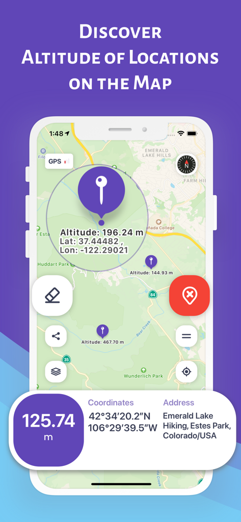
콜로라도의 하이킹 장소에 대한 고도 및 GPS 좌표가 표시된 지도를 보여주는 Altimeter Pro 앱 인터페이스
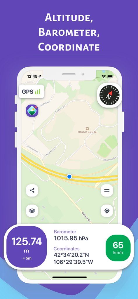
상세 지도에 고도계 및 GPS 좌표를 보여주는 Altimeter Pro 앱 인터페이스
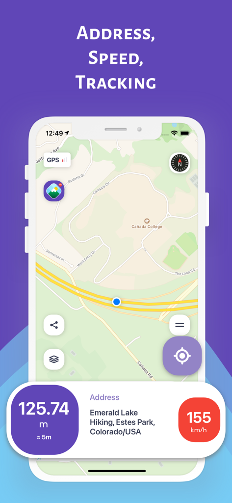
고도 속도 및 위치 주소와 함께 지도 추적을 보여주는 Altimeter Pro 앱 인터페이스
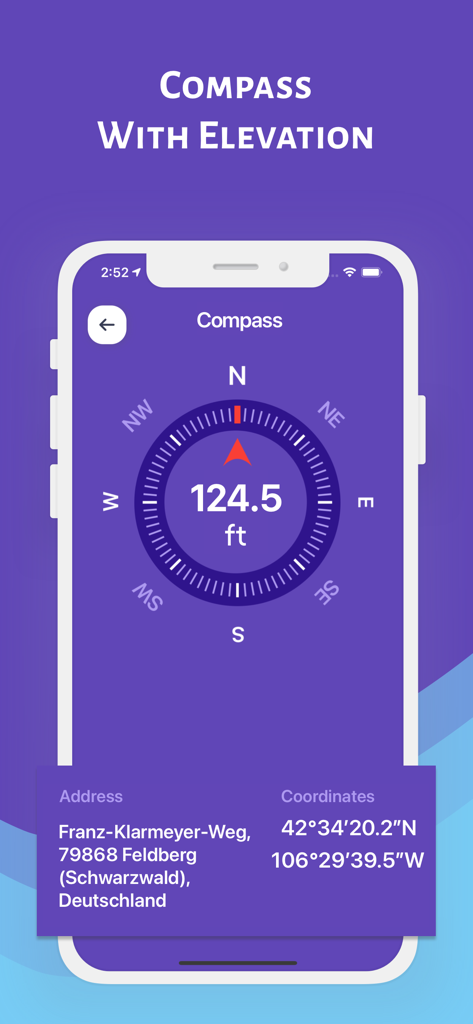
현재 고도 및 GPS 좌표가 있는 디지털 나침반을 표시하는 Altimeter Pro 앱 인터페이스
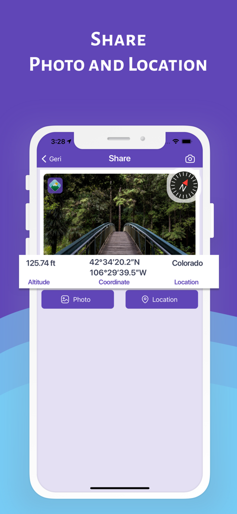
소셜 공유를 위해 고도, GPS 좌표 및 나침반 데이터를 표시하는 Altimeter Pro 앱 내 숲 다리 사진.
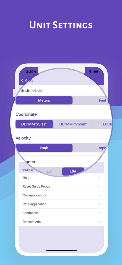
고도, 좌표, 속도 및 기압에 대한 사용자 지정 옵션을 보여주는 Altimeter Pro 앱의 단위 설정 화면.
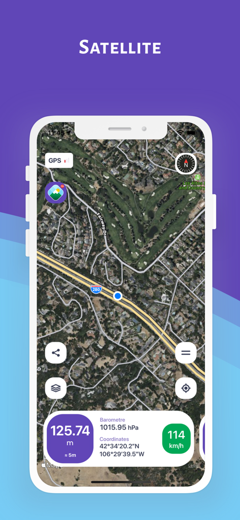
실시간 고도 및 좌표가 있는 위성 지도를 보여주는 Altimeter Pro 앱 스크린샷
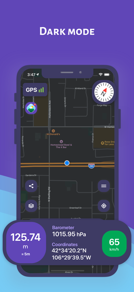
탐색 지도 및 실시간 고도 데이터를 보여주는 다크 모드의 Altimeter Pro 앱 스크린샷
설명
Download
비슷한 앱
같은 카테고리의 상위 앱

Google Maps
Google LLC

Waze Navigation & Live Traffic
waze

AMap Global
AutoNavi Information Technology Co. Ltd.

百度地图-路线规划,出行必备
Beijing Baidu Netcom Science & Technology Co.,Ltd

Moovit: Bus & Transit Tracker
Moovit App Global LTD

Transit • Subway & Bus Times
9280-0366 Quebec inc.

ParkMobile: Park. Pay. Go.
Parkmobile USA, Inc

腾讯地图-路线规划,导航地铁打车出行
Shenzhen Tencent Computer Systems Company Limited

Île-de-France Mobilités
Ile de France Mobilites
이 페이지는 앱이나 개발자의 공식 페이지가 아니며, 정보 제공 및 논평을 목적으로 작성된 독립 편집 간행물입니다. 명시적으로 달리 언급되지 않는 한, 해당 앱이나 개발자는 MWM, Apple, Google Play, 앱 퍼블리셔 또는 앱 개발자와 제휴, 보증, 후원, 승인 또는 공식적으로 연결되어 있지 않으며, 이 페이지의 어떤 내용도 해당 앱이 MWM의 서비스를 사용하여 개발되었음을 의미하지 않습니다. 모든 상표, 로고, 스크린샷 및 기타 콘텐츠는 해당 소유자의 자산입니다.