이 페이지는 앱이나 개발자의 공식 페이지가 아니며, 정보 제공 및 논평을 목적으로 작성된 독립 편집 간행물입니다. 명시적으로 달리 언급되지 않는 한, 해당 앱이나 개발자는 MWM, Apple, Google Play, 앱 퍼블리셔 또는 앱 개발자와 제휴, 보증, 후원, 승인 또는 공식적으로 연결되어 있지 않으며, 이 페이지의 어떤 내용도 해당 앱이 MWM의 서비스를 사용하여 개발되었음을 의미하지 않습니다. 모든 상표, 로고, 스크린샷 및 기타 콘텐츠는 해당 소유자의 자산입니다.

Coordinates – GPS Converter
50개 이상의 좌표 형식으로 변환, 관리 및 탐색할 수 있는 궁극의 전문가 툴킷입니다. 신뢰할 수 있고 오프라인 지원이 가능하며, 중요한 현장 작업 및 극한 탐험을 위해 제작되었습니다.
다운로드
2M+사용자 평점
총 평가 수
7K+개발사
카테고리
Navigation지원 언어
17최신 버전
9.11.3크기
116.3 MB출시일
2012년 1월 18일주머니 속 전문가 수준의 정밀도
지도 이상의 것을 요구하는 측량사, 엔지니어 및 아웃도어 전문가를 위한 궁극의 툴킷입니다. 정밀하고 신뢰할 수 있으며, 가장 기술적인 현장 요구 사항을 위해 제작되었습니다.
범용 좌표 변환
UTM, MGRS, USNG, 위경도 및 50개 이상의 전 세계 데이텀 간에 즉시 전환합니다. 모든 전문가 그리드 시스템을 위한 궁극의 번역기입니다.
미션 크리티컬 오프라인 도구
통신 불가지역에서도 자신 있게 탐색하세요. 오프라인 지도 타일을 다운로드하고, 실시간 고도를 추적하며, 셀 신호 없이 속도계를 사용하세요.
자주 묻는 질문
에 대해 알아야 할 모든 것 Coordinates – GPS Converter
Coordinates – GPS Converter는 무엇에 사용되나요?
Coordinates – GPS Converter는 지리적 위치를 보고, 변환하고, 관리하는 강력한 도구입니다. 다양한 글로벌 좌표 형식과 datums를 지원하며, 탐색, 측정 및 현장 작업을 위한 기능을 제공합니다.
Coordinates – GPS Converter는 어떤 좌표 형식을 지원하나요?
Coordinates – GPS Converter는 UTM, MGRS, Georef, 위도/경도(DD/DM/DMS), what3words, Geohash 등을 포함한 수많은 형식을 지원합니다. 다양한 지질학적 및 투영 시스템을 처리합니다.
Coordinates – GPS Converter를 오프라인으로 사용할 수 있나요?
네, Coordinates – GPS Converter는 오프라인 사용을 지원합니다. 사용자는 특정 도시의 지도 타일을 다운로드하거나 사용자 정의 영역을 정의하여 인터넷 연결 없이 지도에 액세스할 수 있습니다.
Coordinates – GPS Converter는 무료인가요?
네, Coordinates – GPS Converter는 대부분의 기능에 대해 완전히 무료입니다. 광고를 제거하기 위한 구독이 가능합니다. 가격은 지역에 따라 다를 수 있습니다.
Coordinates – GPS Converter는 여러 좌표를 한 번에 변환할 수 있나요?
네, Coordinates – GPS Converter에는 일괄 변환기 기능이 포함되어 있습니다. 이를 통해 사용자는 단일의 간소화된 작업으로 여러 좌표 또는 파일을 신속하게 변환할 수 있습니다.
Coordinates – GPS Converter는 datum 변환을 지원하나요?
네, Coordinates – GPS Converter는 datum 변환을 지원합니다. X/Y, 지질학적 및 투영 시스템을 포함하여 EPSG, ESRI 및 IAU2000 참조를 사용하여 좌표를 변환할 수 있습니다.
Coordinates – GPS Converter에는 어떤 측정 도구가 있나요?
Coordinates – GPS Converter는 거리, 방위 및 면적을 측정하는 도구를 제공합니다. 사용자는 지도에 직접 지점을 표시하거나 선을 그려 이러한 측정을 수행할 수 있습니다.
Coordinates – GPS Converter는 PROJ.4와 통합되나요?
네, Coordinates – GPS Converter에는 PROJ.4 계산기가 포함되어 있습니다. 이를 통해 PROJ.4 라이브러리를 사용하여 datum 이동 및 사용자 정의 투영을 지원하는 시스템 간 변환이 가능합니다.
사용자는 Coordinates – GPS Converter에서 저장된 위치에 메모와 미디어를 추가할 수 있나요?
네, Coordinates – GPS Converter를 사용하면 사용자는 핀, 도형 또는 측정값과 같은 저장된 모든 객체에 메모, 사진 및 미디어를 추가할 수 있습니다. 이를 통해 데이터를 체계적으로 관리하고 맥락을 풍부하게 유지할 수 있습니다.
Coordinates – GPS Converter는 어떤 파일 형식을 가져오고 내보낼 수 있나요?
Coordinates – GPS Converter는 .gpx, .geojson 및 .kml 파일 형식을 가져오고 내보낼 수 있습니다. 이를 통해 위치 데이터에 대한 공유 및 데이터 관리가 용이합니다.
Coordinates – GPS Converter에는 속도계가 포함되어 있나요?
네, Coordinates – GPS Converter에는 내장 속도계가 있습니다. 사용자의 현재 속도를 실시간으로 직접 애플리케이션 내에서 추적하고 표시합니다.
Coordinates – GPS Converter를 사용하여 어떤 단위로 변환할 수 있나요?
Coordinates – GPS Converter에는 40개 이상의 단위 유형을 처리하는 단위 변환기가 포함되어 있습니다. 이러한 범주에는 거리, 압력, 방사선, 전류, 열 밀도 등이 포함됩니다.
다음 스크린샷과 설명은 앱의 공식 스토어 목록에서 직접 가져온 것이며 앱 개발자의 자산입니다.
앱 스토어
스크린샷
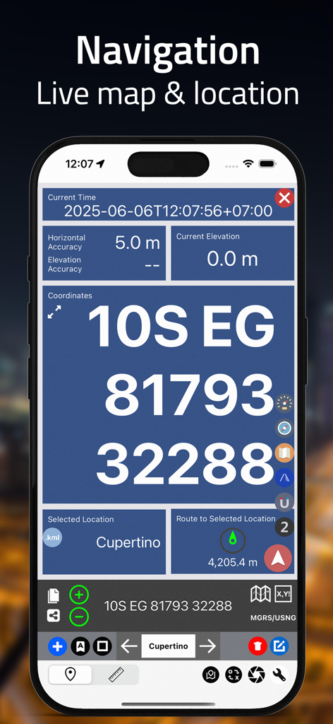
MGRS 좌표와 위치 정확도를 보여주는 실시간 탐색 화면.
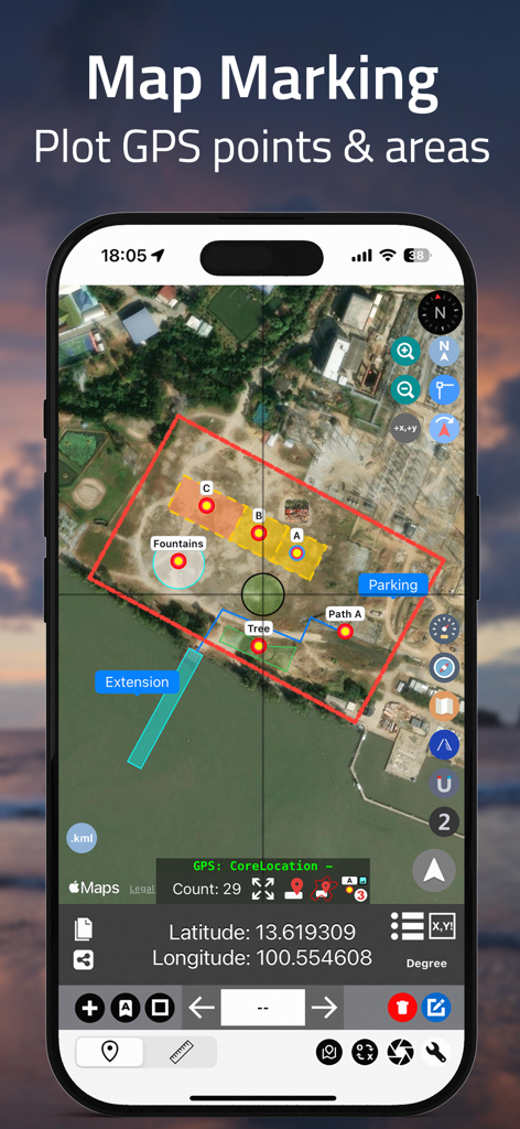
좌표 앱 인터페이스는 위성 지도 마킹과 플롯된 GPS 지점 및 색상으로 구분된 지형 영역을 보여줍니다.
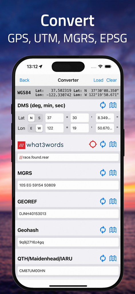
DMS MGRS 및 what3words 형식 간의 좌표 변환을 보여주는 iPhone 화면
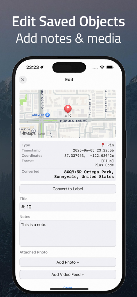
좌표 앱의 인터페이스는 메모를 추가하고 GPS 핀에 미디어를 첨부하여 저장된 개체를 편집하는 방법을 보여줍니다.
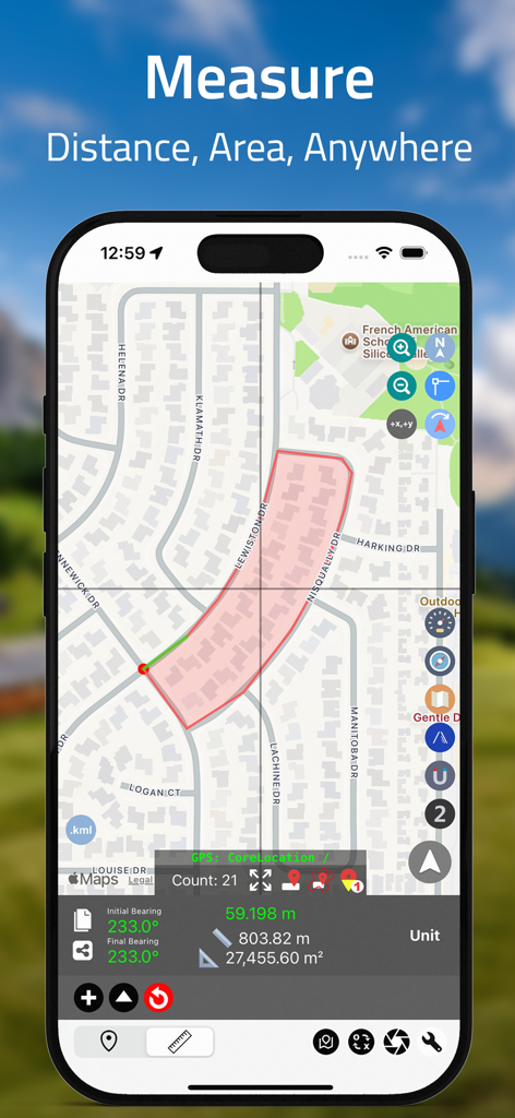
좌표 앱이 주거용 지도에서 지형 면적과 거리를 측정하는 것을 보여주는 iPhone 화면.
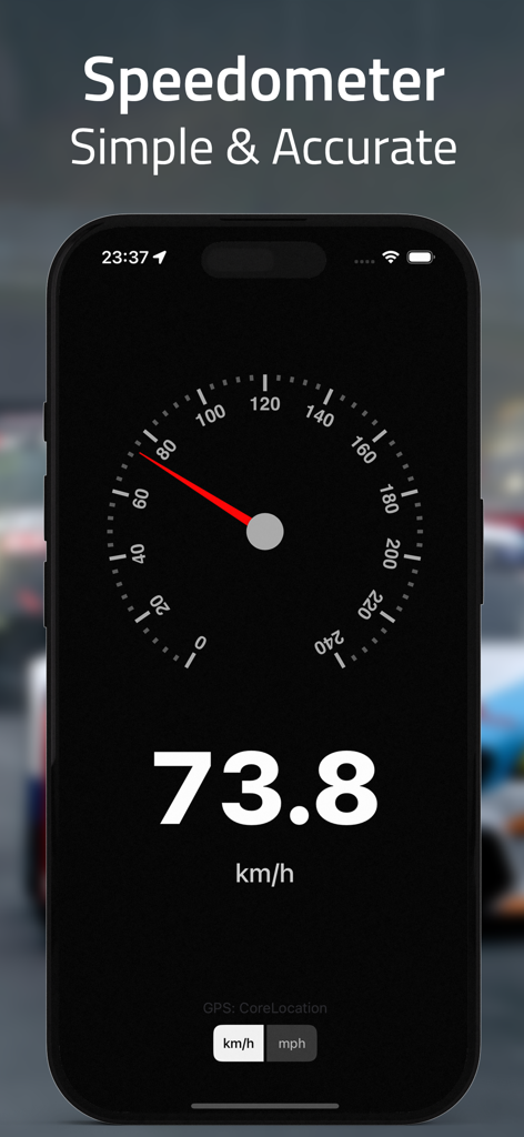
좌표 앱의 스크린샷으로, 73.8km/h를 보여주는 정확한 디지털 및 아날로그 속도계가 표시됩니다.
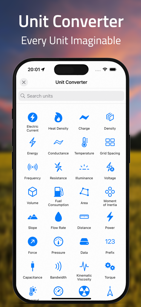
압력, 에너지, 거리와 같은 범주를 보여주는 단위 변환을 위한 모바일 앱 인터페이스.
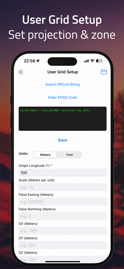
GPS 변환기 앱에서 사용자 정의 투영 및 영역을 설정하기 위한 사용자 그리드 설정 화면.
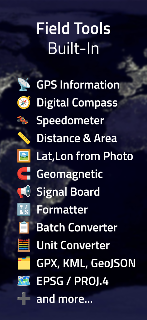
디지털 나침반, 속도계 및 일괄 좌표 변환기를 포함한 내장형 전문가 현장 도구 목록.
설명
Download
비슷한 앱
유사한 기능과 사용자 경험을 가진 앱

MilGPS
Cascode Labs Pty Ltd

SEAiq Pilot VPP
Sakhalin, LLC

Cartograph Maps 3
Harald Meyer

新知卫星地图-路线规划,高清地图导航
Chongqing Xinzhi Space Technology Co., Ltd.

Mgrs & Utm Map
Vahid Cataltas

DeepStateMap
Heorhii Karpenko

Map Plus
Miocool Inc.

Compass 55. Map & GPS kit.
Kalimex-Consulting s.r.o.

Vetus Maps
Andrey Fetisov
이 페이지는 앱이나 개발자의 공식 페이지가 아니며, 정보 제공 및 논평을 목적으로 작성된 독립 편집 간행물입니다. 명시적으로 달리 언급되지 않는 한, 해당 앱이나 개발자는 MWM, Apple, Google Play, 앱 퍼블리셔 또는 앱 개발자와 제휴, 보증, 후원, 승인 또는 공식적으로 연결되어 있지 않으며, 이 페이지의 어떤 내용도 해당 앱이 MWM의 서비스를 사용하여 개발되었음을 의미하지 않습니다. 모든 상표, 로고, 스크린샷 및 기타 콘텐츠는 해당 소유자의 자산입니다.