이 페이지는 앱이나 개발자의 공식 페이지가 아니며, 정보 제공 및 논평을 목적으로 작성된 독립 편집 간행물입니다. 명시적으로 달리 언급되지 않는 한, 해당 앱이나 개발자는 MWM, Apple, Google Play, 앱 퍼블리셔 또는 앱 개발자와 제휴, 보증, 후원, 승인 또는 공식적으로 연결되어 있지 않으며, 이 페이지의 어떤 내용도 해당 앱이 MWM의 서비스를 사용하여 개발되었음을 의미하지 않습니다. 모든 상표, 로고, 스크린샷 및 기타 콘텐츠는 해당 소유자의 자산입니다.

Coverage?
주요 통신사의 5G, LTE 및 로밍 지도를 오버레이하고 비교하는 테크노마드를 위한 필수 도구. 오프라인으로 독점 커버리지 데이터에 액세스하고 미국과 캐나다 전역에서 자신 있게 여행을 계획하세요.
다운로드
210K+사용자 평점
총 평가 수
1K+개발사
카테고리
Navigation지원 언어
1최신 버전
2025.4크기
34.9 MB출시일
2010년 12월 22일연결성 마스터하기
신호가 어디에 있을지 추측하는 것을 멈추세요. Coverage?는 포괄적인 크로스 통신사 지도를 주머니에 넣어 스트레스 없는 여행과 안정적인 원격 근무를 지원합니다.
오프라인에서의 평온함
고해상도 지도가 기기에 직접 저장됩니다. 신호가 전혀 없는 지역에서도 신호를 찾아 길을 찾을 수 있습니다.
크로스 통신사 오버레이
AT&T, Verizon, T-Mobile, Dish를 직접 비교하세요. 다음 캠핑장이나 원격지에서 어떤 통신사가 우수한지 즉시 확인하세요.
다음 스크린샷과 설명은 앱의 공식 스토어 목록에서 직접 가져온 것이며 앱 개발자의 자산입니다.
앱 스토어
스크린샷
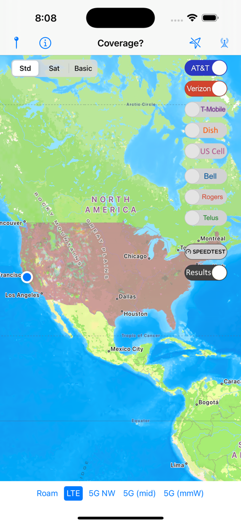
북미 전역의 셀룰러 신호 지도를 표시하고 통신사 토글이 있는 Coverage 앱 인터페이스.
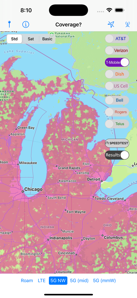
미시간 및 주변 지역의 T-Mobile 5G 네트워크 커버리지를 보여주는 Coverage 앱 인터페이스.
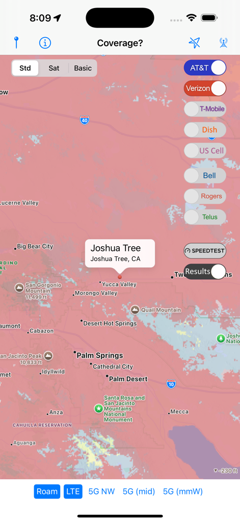
캘리포니아 조슈아 트리 지역의 셀룰러 신호 비교 지도를 보여주는 Coverage 앱
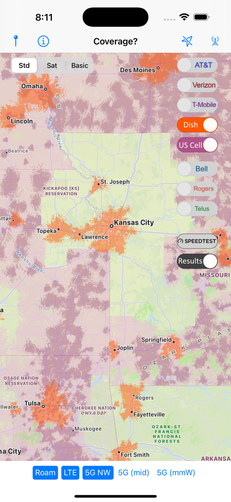
캔자스시티 지역의 Dish 네트워크 신호 강도를 보여주는 셀룰러 커버리지 지도.
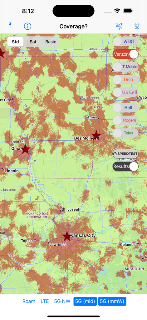
미국 중서부의 Verizon 5G 셀룰러 커버리지를 보여주는 Coverage 앱의 지도 보기.
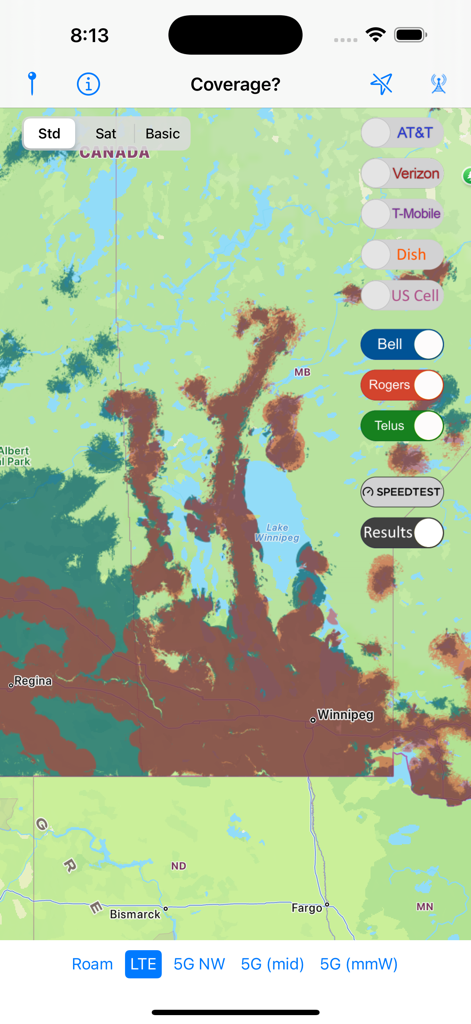
캐나다 통신사 Bell Rogers 및 Telus에 대한 셀룰러 커버리지 지도 오버레이
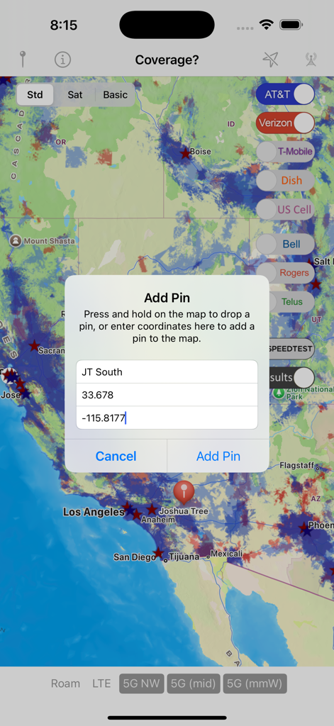
셀룰러 네트워크 지도 위에 지리 좌표가 있는 핀 추가 대화 상자를 표시하는 Coverage 앱 인터페이스.
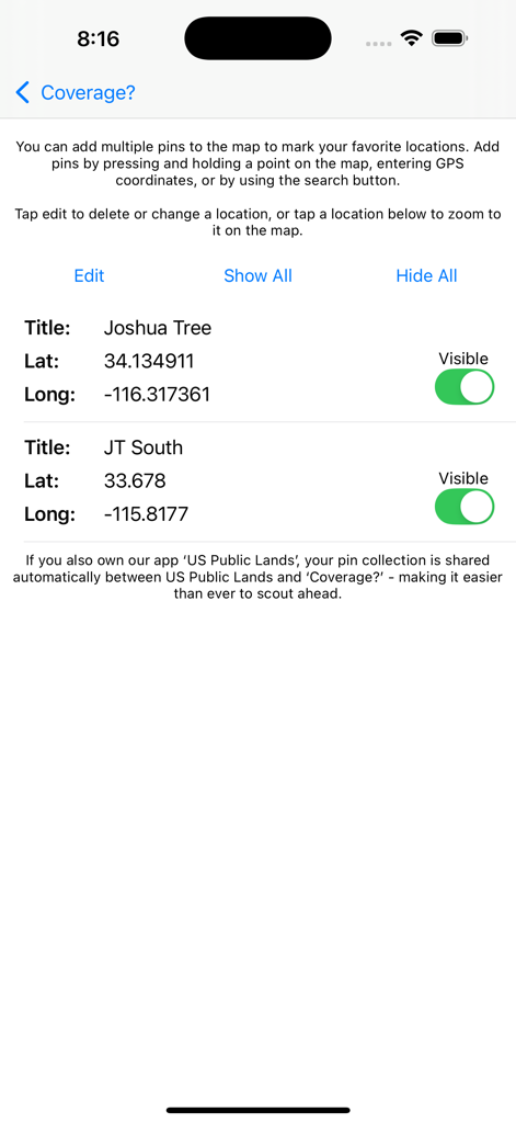
Coverage 앱에서 조슈아 트리에 대한 GPS 좌표가 있는 관리된 위치 핀을 보여주는 화면
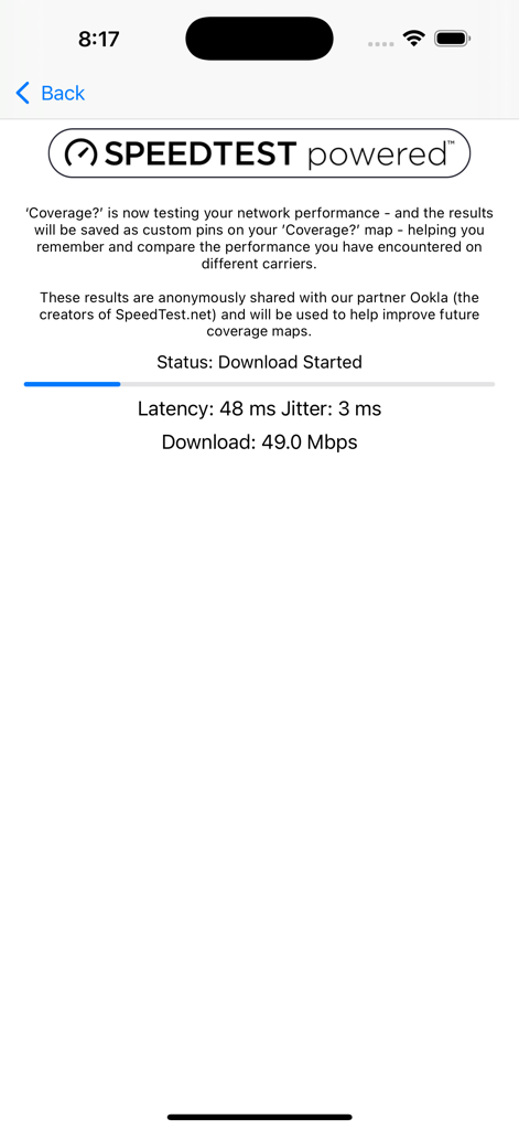
Ookla에서 제공하는 다운로드 속도 및 지연 시간을 포함한 실시간 네트워크 성능 결과를 보여주는 Coverage 앱의 화면.
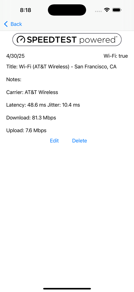
샌프란시스코에서 AT&T Wireless의 다운로드 및 업로드 속도를 보여주는 네트워크 속도 테스트 결과 화면
설명
Download
비슷한 앱
같은 카테고리의 상위 앱

Google Maps
Google LLC

Waze Navigation & Live Traffic
waze

AMap Global
AutoNavi Information Technology Co. Ltd.

百度地图-路线规划,出行必备
Beijing Baidu Netcom Science & Technology Co.,Ltd

Moovit: Bus & Transit Tracker
Moovit App Global LTD

Transit • Subway & Bus Times
9280-0366 Quebec inc.

ParkMobile: Park. Pay. Go.
Parkmobile USA, Inc

腾讯地图-路线规划,导航地铁打车出行
Shenzhen Tencent Computer Systems Company Limited

Île-de-France Mobilités
Ile de France Mobilites
이 페이지는 앱이나 개발자의 공식 페이지가 아니며, 정보 제공 및 논평을 목적으로 작성된 독립 편집 간행물입니다. 명시적으로 달리 언급되지 않는 한, 해당 앱이나 개발자는 MWM, Apple, Google Play, 앱 퍼블리셔 또는 앱 개발자와 제휴, 보증, 후원, 승인 또는 공식적으로 연결되어 있지 않으며, 이 페이지의 어떤 내용도 해당 앱이 MWM의 서비스를 사용하여 개발되었음을 의미하지 않습니다. 모든 상표, 로고, 스크린샷 및 기타 콘텐츠는 해당 소유자의 자산입니다.