이 페이지는 앱이나 개발자의 공식 페이지가 아니며, 정보 제공 및 논평을 목적으로 작성된 독립 편집 간행물입니다. 명시적으로 달리 언급되지 않는 한, 해당 앱이나 개발자는 MWM, Apple, Google Play, 앱 퍼블리셔 또는 앱 개발자와 제휴, 보증, 후원, 승인 또는 공식적으로 연결되어 있지 않으며, 이 페이지의 어떤 내용도 해당 앱이 MWM의 서비스를 사용하여 개발되었음을 의미하지 않습니다. 모든 상표, 로고, 스크린샷 및 기타 콘텐츠는 해당 소유자의 자산입니다.

Elevation - Altimeter Map
야외 모험 및 부동산 안전을 위한 전문가의 선택. 클라우드, GPS, 기압 센서를 통해 정확한 고도 데이터에 접근하여 자신 있게 모든 지형을 탐색하세요.
다운로드
1M+사용자 평점
총 평가 수
13K+개발사
카테고리
Navigation지원 언어
14최신 버전
4.13.2크기
63.4 MB출시일
2011년 11월 22일모든 지형을 위한 정밀 탐색
산에서의 최고 성능부터 집에서의 침수 위험 평가까지, 클라우드, GPS 및 기압 센서를 사용하여 세계에서 가장 정확한 고도 데이터를 얻으세요.
삼중 소스 정확도
클라우드 데이터, GPS 및 내장 기압 센서를 원활하게 상호 참조하여 모든 장치에서 가장 정확한 고도 판독값을 확보하세요.
부동산 및 침수 정보
해수면 기준 정확한 높이를 평가하여 투자를 보호하고 안전을 확보하세요. 침수 위험 모니터링 및 부동산 조사에 필수적입니다.
자주 묻는 질문
에 대해 알아야 할 모든 것 Elevation - Altimeter Map
Elevation - Altimeter Map 앱의 주요 기능은 무엇인가요?
Elevation - Altimeter Map 앱은 사용자가 현재 고도, 높이, 해발 높이를 찾는 데 도움을 줍니다. 지구상의 다양한 위치에 대한 고도 데이터를 제공합니다.
Elevation - Altimeter Map은 어떻게 고도를 결정하나요?
Elevation - Altimeter Map 앱은 온라인 데이터베이스, 내장 GPS 또는 기기의 기압계를 사용하여 고도를 결정합니다. 사용자는 주소를 입력하거나 지도를 이동할 수도 있습니다.
Elevation - Altimeter Map을 사용하여 GPS 고도를 측정할 수 있나요?
네, Elevation - Altimeter Map은 기기의 내장 GPS를 사용하여 현재 위치의 고도를 결정합니다. 경로는 다채로운 선으로 기록되고 표시됩니다.
Elevation - Altimeter Map은 기압계 고도 측정을 지원하나요?
네, Elevation - Altimeter Map은 기기의 내장 기압계를 사용하여 고도를 측정합니다. 원시 기압계 데이터 또는 해수면에서의 상대 압력에서 측정되며 다채로운 선으로 표시됩니다.
Elevation - Altimeter Map은 어떤 좌표 형식을 지원하나요?
Elevation - Altimeter Map은 일반적인 위도 및 경도, UTM(Universal Transverse Mercator), MGRS(Military Grid Reference System)를 지원합니다.
Elevation - Altimeter Map은 고도 및 압력 데이터를 내보낼 수 있나요?
네, Elevation - Altimeter Map을 사용하면 타임스탬프, 고도, 압력, 좌표를 포함한 정보를 내보낼 수 있습니다.
Elevation - Altimeter Map은 무료로 다운로드하여 사용할 수 있나요?
네, Elevation - Altimeter Map은 모든 기능을 무료로 사용할 수 있습니다. 광고 제거 및 데이터 지연 감소를 위한 선택적 구독이 가능합니다.
Elevation - Altimeter Map의 구독 비용은 얼마인가요?
Elevation - Altimeter Map의 구독 비용은 월 $4.49, 6개월 $25.99, 연간 $48.99입니다. 가격은 지역에 따라 다릅니다.
Elevation - Altimeter Map 구독은 어떤 기능을 제공하나요?
Elevation - Altimeter Map을 구독하면 광고가 제거되고 데이터 검색 지연이 50% 감소합니다. 다른 모든 앱 기능은 무료로 유지됩니다.
Elevation - Altimeter Map을 독립형 기압계로 사용할 수 있나요?
네, Elevation - Altimeter Map은 독립형 기압계로 작동하여 기기를 사용하여 대기압을 측정할 수 있습니다.
Elevation - Altimeter Map에 대기압 및 고도 계산기가 포함되어 있나요?
네, Elevation - Altimeter Map에는 대기압/고도 계산기가 있습니다. 알려진 고도, 압력, 온도 및 해수면 압력에서 대기압 및/또는 고도를 계산합니다.
Elevation - Altimeter Map을 사용하여 두 위치 간의 고도를 비교하는 방법은 무엇인가요?
Elevation - Altimeter Map은 고도 비교를 위해 "범위 모드"를 제공합니다. 이 기능은 선택한 두 위치 간의 고도에 대한 그래프 및 선 표시를 제공합니다.
다음 스크린샷과 설명은 앱의 공식 스토어 목록에서 직접 가져온 것이며 앱 개발자의 자산입니다.
앱 스토어
스크린샷
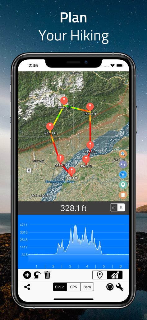
Elevation Altimeter Map 앱 인터페이스가 위성 지도와 고도 프로필 그래프가 있는 하이킹 경로 계획 화면을 보여줌
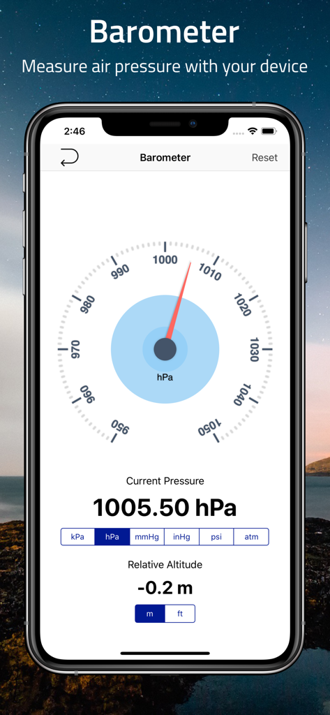
스마트폰이 기압 및 상대 고도를 표시하는 Elevation Altimeter 앱의 기압계 기능을 보여줌
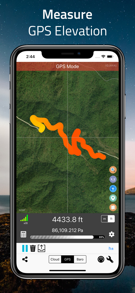
스마트폰이 위성 지도에 4433.8피트 고도를 표시하는 다채로운 트랙이 있는 GPS 모드의 Elevation Altimeter 앱을 표시함
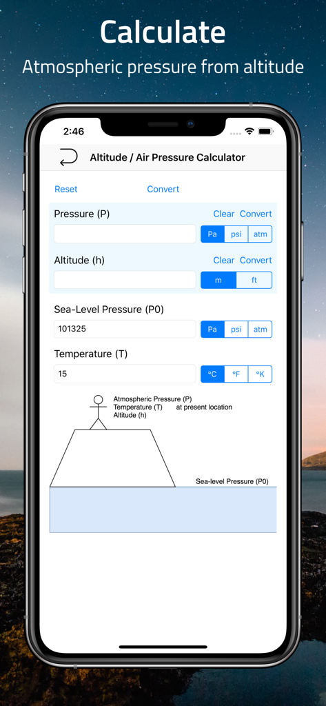
압력 고도 및 온도를 위한 필드가 있는 고도 및 기압 계산기를 보여주는 모바일 앱 인터페이스
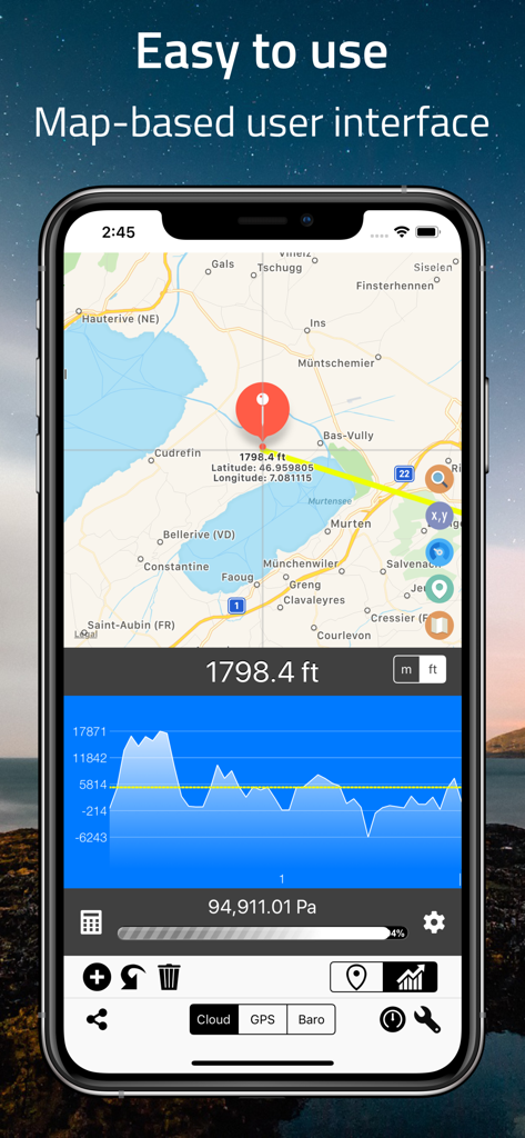
Elevation Altimeter Map 앱 스크린샷으로 고도 데이터와 지형 프로필 그래프가 있는 지도 인터페이스를 보여줌
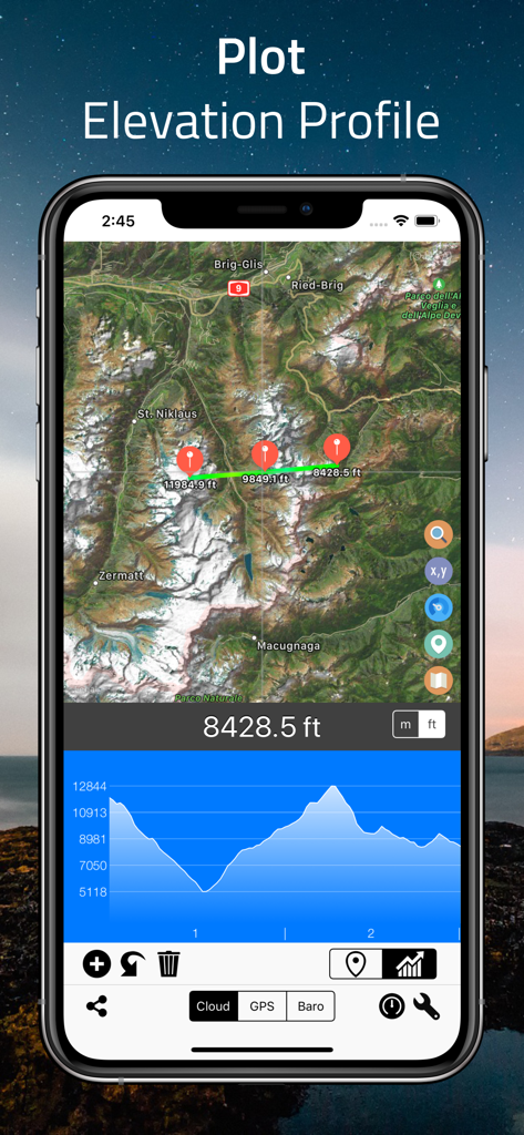
Elevation Altimeter Map 앱 인터페이스가 고도 프로필 플롯과 고도 그래프가 있는 위성 지도를 보여줌
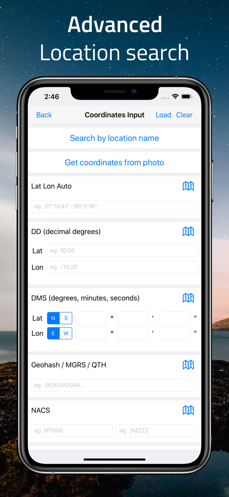
GPS DMS 및 MGRS와 같은 다양한 형식의 수동 좌표 입력을 위한 고급 위치 검색 화면
설명
Download
비슷한 앱
유사한 기능과 사용자 경험을 가진 앱

经纬度指南针-测方位实时海拔天气相机
Guangzhou Duoyi Network Technology Co., Ltd.

My Altitude: GPS Altimeter
Enacti Ventures Private Limited

Compass & GPS
Seong Eon Kim

Compass App - Qibla finder
Simple Start Technologies

Compass & Coordinates Locator
ALVICOMP OU

Compass∞
Camera LLC(TX)

Compass - Professional
Peter Bohl

Altimeter GPS & Barometer
Andrea Terdich

Compass - GPS Altimeter
伟 雷
이 페이지는 앱이나 개발자의 공식 페이지가 아니며, 정보 제공 및 논평을 목적으로 작성된 독립 편집 간행물입니다. 명시적으로 달리 언급되지 않는 한, 해당 앱이나 개발자는 MWM, Apple, Google Play, 앱 퍼블리셔 또는 앱 개발자와 제휴, 보증, 후원, 승인 또는 공식적으로 연결되어 있지 않으며, 이 페이지의 어떤 내용도 해당 앱이 MWM의 서비스를 사용하여 개발되었음을 의미하지 않습니다. 모든 상표, 로고, 스크린샷 및 기타 콘텐츠는 해당 소유자의 자산입니다.