이 페이지는 앱이나 개발자의 공식 페이지가 아니며, 정보 제공 및 논평을 목적으로 작성된 독립 편집 간행물입니다. 명시적으로 달리 언급되지 않는 한, 해당 앱이나 개발자는 MWM, Apple, Google Play, 앱 퍼블리셔 또는 앱 개발자와 제휴, 보증, 후원, 승인 또는 공식적으로 연결되어 있지 않으며, 이 페이지의 어떤 내용도 해당 앱이 MWM의 서비스를 사용하여 개발되었음을 의미하지 않습니다. 모든 상표, 로고, 스크린샷 및 기타 콘텐츠는 해당 소유자의 자산입니다.

Field Area Measure on GPS Map
전문가 수준의 정확도로 면적을 계산하고, 경계를 추적하며, 토지 프로젝트를 관리하세요. 농부, 부동산 중개인, 측량사가 모든 필지를 측정하고 보고서를 즉시 내보낼 수 있는 필수적인 오프라인 도구입니다.
다운로드
600사용자 평점
총 평가 수
0개발사
카테고리
Utilities지원 언어
1최신 버전
1.5크기
97.6 MB출시일
2025년 7월 15일전문가의 정밀함으로 토지를 측정하세요
초당 면적, 거리, 둘레를 계산합니다. 현장에서든 사무실에서든 농업, 부동산, 건설에 필요한 정확한 데이터를 얻으세요.
GPS 경계 추적
휴대폰으로 경계를 따라 걷기만 하면 필지 면적과 둘레가 계산됩니다. 대규모 농장 및 토지 관리에 완벽합니다.
신뢰할 수 있는 오프라인 액세스
외딴 농촌 지역에서도 자신 있게 작업하세요. 셀룰러 신호 없이도 토지를 매핑하고 측정할 수 있어 데이터에 항상 액세스할 수 있습니다.
다음 스크린샷과 설명은 앱의 공식 스토어 목록에서 직접 가져온 것이며 앱 개발자의 자산입니다.
앱 스토어
스크린샷
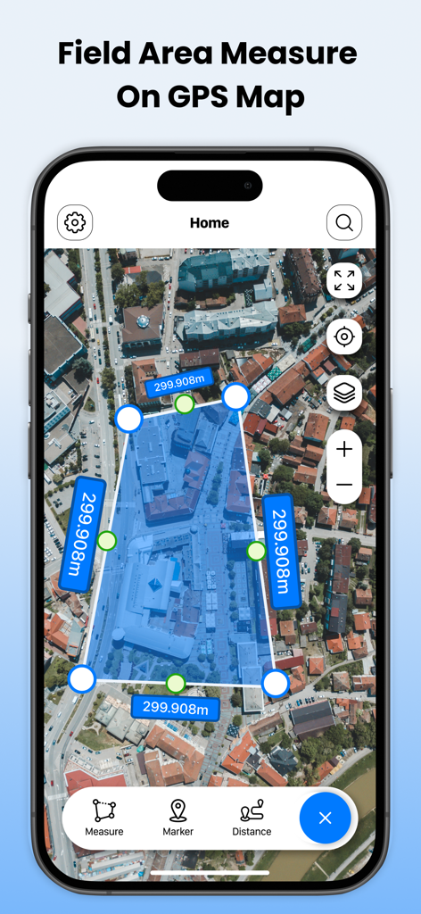
GPS 지도를 이용한 필지 면적 측량 앱 인터페이스가 위성 지도에 면적 측정 다각형을 표시하고 있음
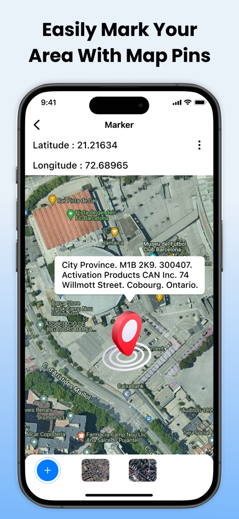
GPS 좌표 및 주소 세부 정보와 함께 위성 지도에 빨간색 핀 마커를 보여주는 Field Area Measure 앱 스크린샷.
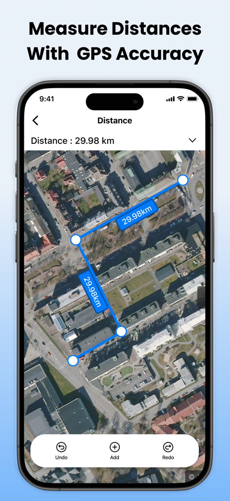
총 거리 29.98km를 측정하는 파란색 마커와 선이 있는 위성 지도 보기를 보여주는 스마트폰
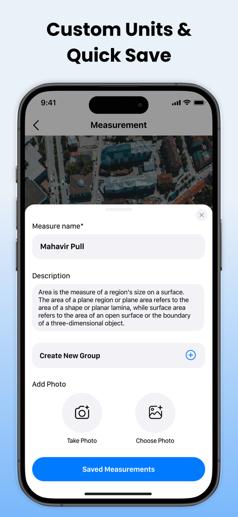
GPS 토지 측정에 이름, 설명, 사진 추가 옵션을 보여주는 모바일 앱 인터페이스.
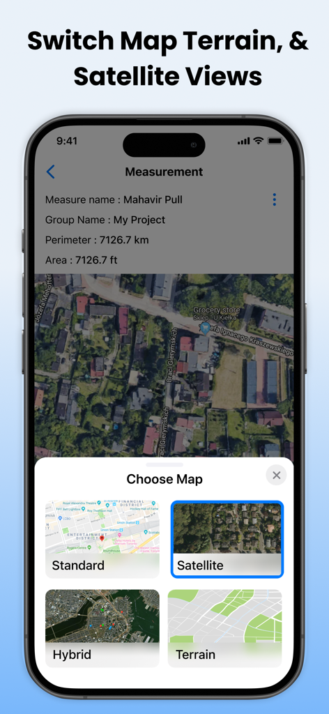
표준 위성, 하이브리드 및 지형 지도 보기 간 전환 옵션을 보여주는 인터페이스
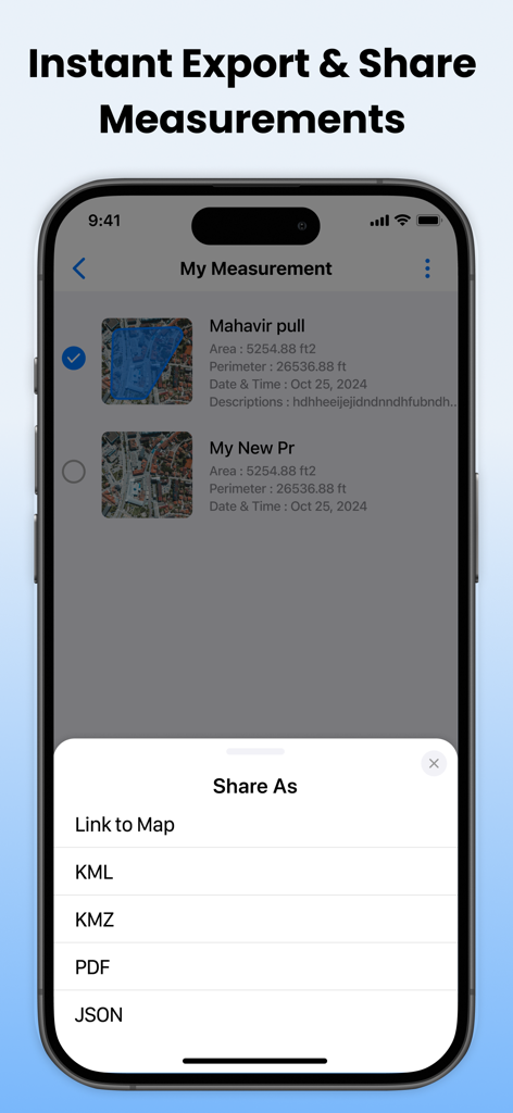
KML 및 PDF 형식을 포함한 토지 측정 내보내기 옵션을 보여주는 모바일 앱 화면
설명
Download
비슷한 앱
같은 카테고리의 상위 앱

Google LLC

Google Chrome
Google LLC

中国移动(手机营业厅)
China Mobile Online Services Co., Ltd.

Google Authenticator
Google LLC

CNH do Brasil
Servicos e Informacoes do Brasil

Cleanup: Phone Storage Cleaner
DEEP FLOW SOFTWARE SERVICES - FZCO

gov.br
Servicos e Informacoes do Brasil

中国电信-全国统一官方服务平台
CHINA TELECOM Corporation Ltd.

Microsoft Edge: AI Browser
Microsoft Corporation
이 페이지는 앱이나 개발자의 공식 페이지가 아니며, 정보 제공 및 논평을 목적으로 작성된 독립 편집 간행물입니다. 명시적으로 달리 언급되지 않는 한, 해당 앱이나 개발자는 MWM, Apple, Google Play, 앱 퍼블리셔 또는 앱 개발자와 제휴, 보증, 후원, 승인 또는 공식적으로 연결되어 있지 않으며, 이 페이지의 어떤 내용도 해당 앱이 MWM의 서비스를 사용하여 개발되었음을 의미하지 않습니다. 모든 상표, 로고, 스크린샷 및 기타 콘텐츠는 해당 소유자의 자산입니다.