이 페이지는 앱이나 개발자의 공식 페이지가 아니며, 정보 제공 및 논평을 목적으로 작성된 독립 편집 간행물입니다. 명시적으로 달리 언급되지 않는 한, 해당 앱이나 개발자는 MWM, Apple, Google Play, 앱 퍼블리셔 또는 앱 개발자와 제휴, 보증, 후원, 승인 또는 공식적으로 연결되어 있지 않으며, 이 페이지의 어떤 내용도 해당 앱이 MWM의 서비스를 사용하여 개발되었음을 의미하지 않습니다. 모든 상표, 로고, 스크린샷 및 기타 콘텐츠는 해당 소유자의 자산입니다.
FltPlan Go
FltPlan.com에서 직접 비행 계획, NavLogs, 지오레퍼런스 차트를 원활하게 동기화하세요. 안전을 중시하는 조종사를 위해 설계된 종합적인 매핑, 날씨 오버레이, 항공전자 장비 통합 기능을 경험하세요.
FltPlan.com에서 iPad로 비행 계획을 원활하게 동기화하세요. 모든 임무가 정밀하게 수행되도록 필수 오프라인 차트, 실시간 날씨 및 통합 항공전자 장비 지원에 액세스하세요.
원활한 동기화 및 오프라인 액세스
FltPlan.com에서 계획을 생성하고 즉시 동기화하세요. 비행 중 신뢰할 수 있는 100% 오프라인 사용을 위해 NavLogs와 차트를 다운로드하세요.
전체 상황 인식
대화형 이동 지도에 지오레퍼런스 접근 플레이트, METAR, ADS-B 트래픽을 오버레이하여 날씨와 경로를 앞서나가세요.
다음 스크린샷과 설명은 앱의 공식 스토어 목록에서 직접 가져온 것이며 앱 개발자의 자산입니다.
앱 스토어
스크린샷
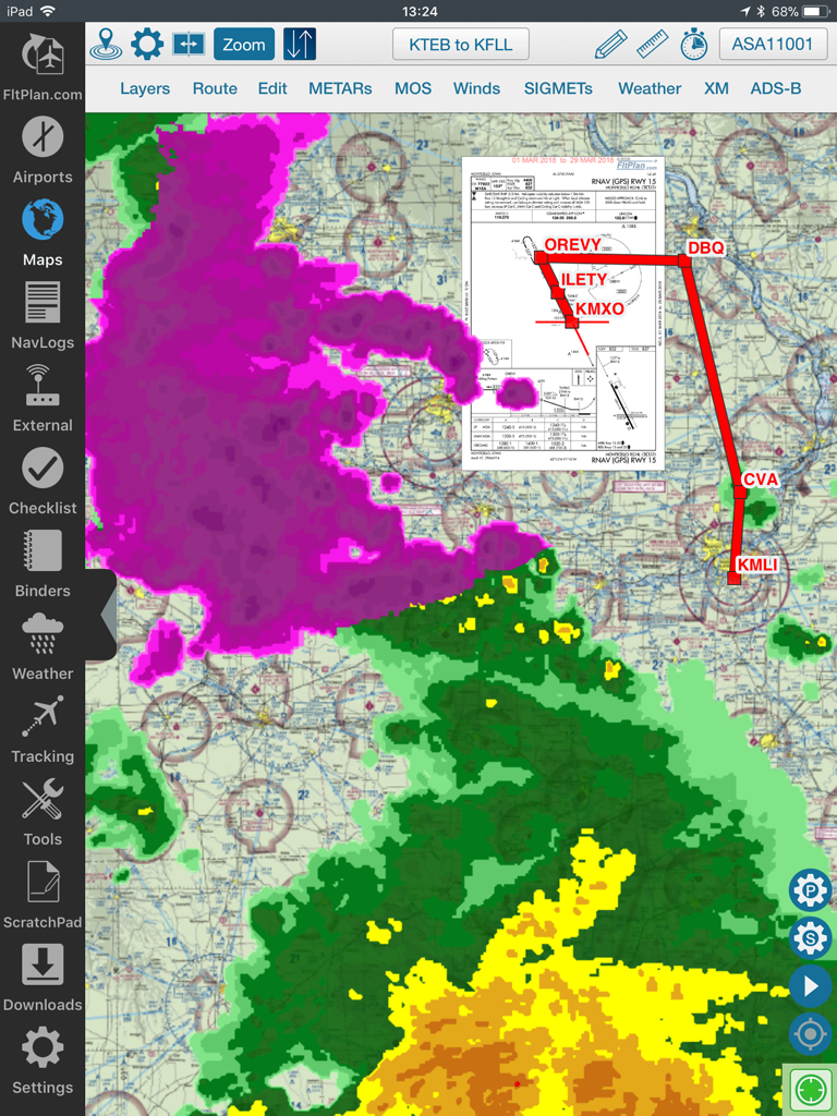
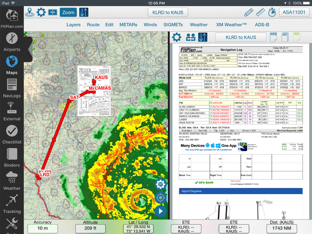
FltPlan Go iPad 앱 인터페이스에 비행 경로 날씨 레이더 오버레이와 접근 플레이트가 표시된 이동 지도가 표시됩니다.
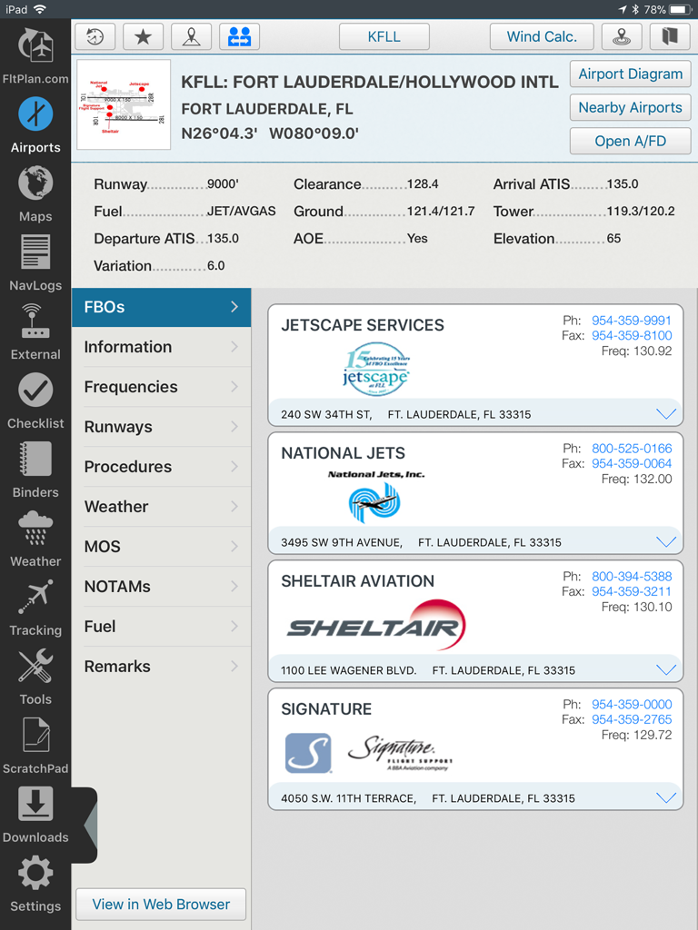
FltPlan Go iPad 인터페이스에 KFLL Fort Lauderdale의 공항 정보 및 FBO 서비스가 표시됩니다.
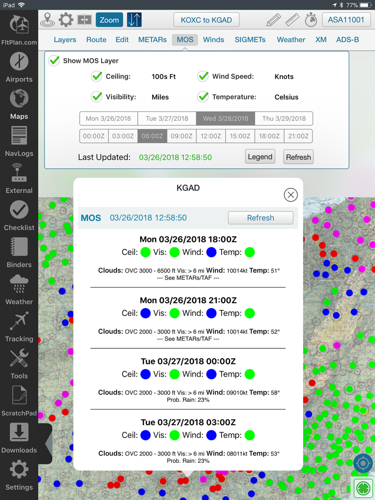
FltPlan Go iPad 애플리케이션에 비행 지도에 MOS 날씨 예보 데이터가 표시됩니다.
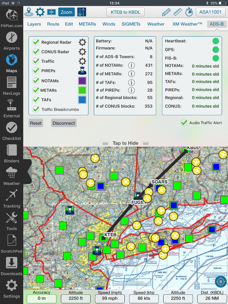
FltPlan Go iPad 인터페이스에 비행 경로, 날씨 오버레이 및 ADS-B 상태 데이터가 표시된 이동 지도가 표시됩니다.
날씨 레이더와 항법 로그가 있는 이동 지도가 표시되는 FltPlan Go iPad의 분할 화면 보기
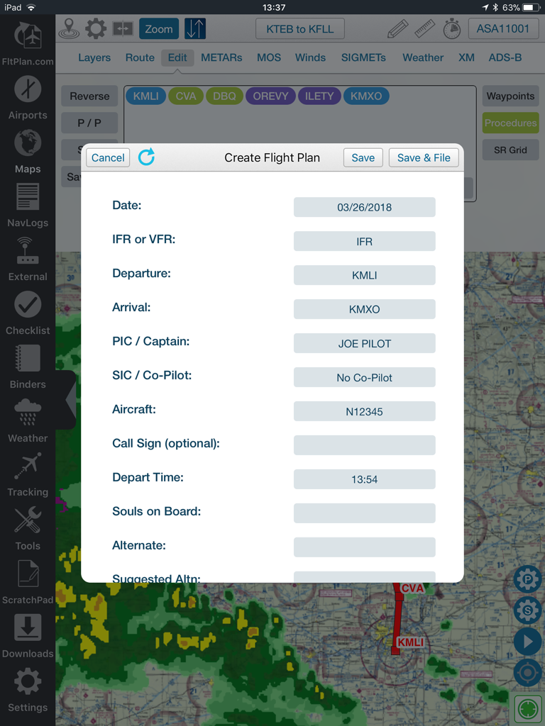
날씨 오버레이가 있는 항법 지도 위에서 FltPlan Go 앱에서 비행 계획 양식을 작성하는 조종사.
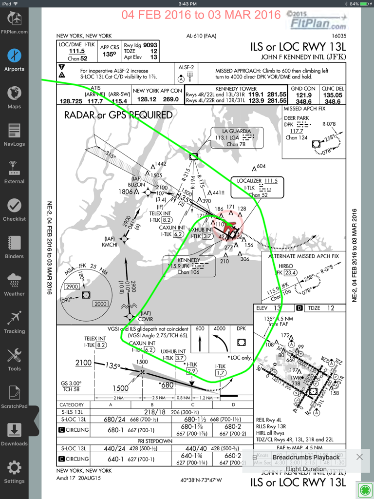
FltPlan Go iPad 앱에 녹색 빵 부스러기 비행 경로 오버레이가 있는 JFK 공항 ILS 접근 플레이트가 표시됩니다.
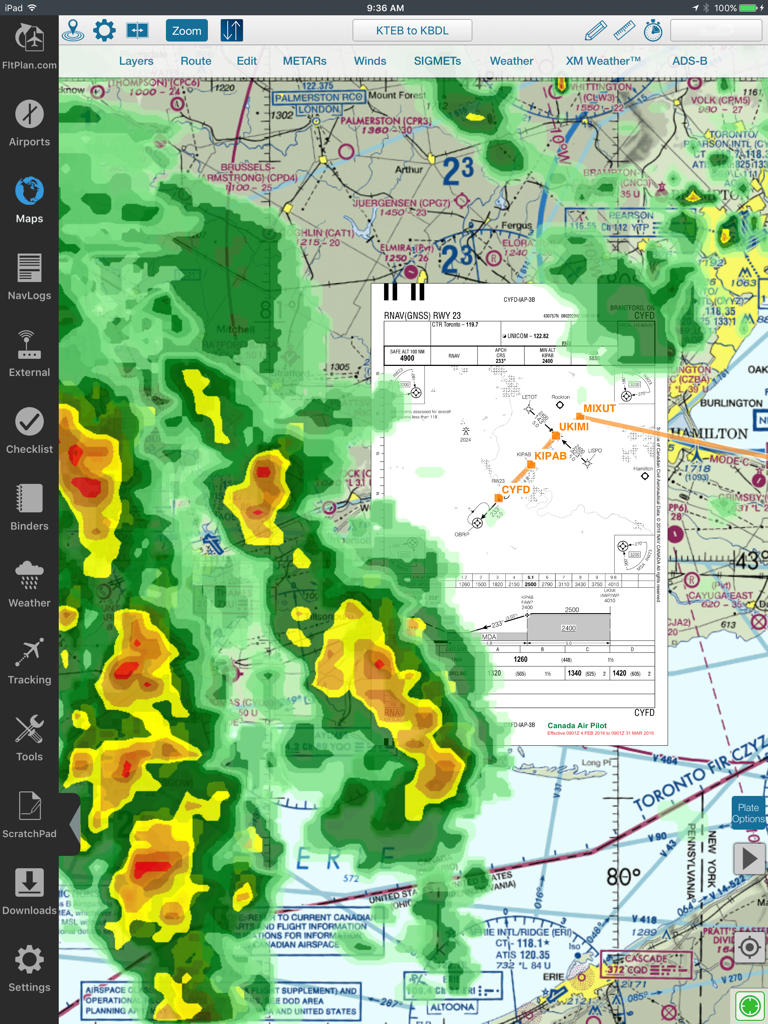
날씨 레이더와 접근 플레이트 오버레이가 있는 FltPlan의 항공 이동 지도
설명
FltPlan Go is the essential companion to FltPlan.com. Because FltPlan Go is integrated with FltPlan.com, flight plans and NavLogs are automatically synced to your device along with Weight & Balance profiles, eLogbook profiles, and Checklists for offline and in-flight use.
• Create and file your flight plan on FltPlan.com, and it will sync to FltPlan Go to allow you to responsively edit the flight plan on the map
• NavLogs are automatically synced and downloaded for offline use
• Create and file your flight plan on FltPlan Go to sync to FltPlan.com
FltPlan Go delivers powerful routing, weather, mapping features, and comprehensive aviation information including:
AIRPORTS:
• Airport & FBO Information including current fuel prices
• Geo-Referenced approach plates & airport diagrams (U.S & Canada)
• Weather, including METARs, TAFs, PIREPs, & MOS
• NOTAMs & Remarks
MAPS:
• Sync FltPlan.com flight plans and interactively edit on the map
• File a flight plan from within FltPlan Go
• Moving maps with sectionals, enroute charts, & more
• Overlay approach plates & procedures on the map
• Layers including SUAs, TFRs, State Outline, Airports, Fuel Prices, CAP Grid, Stadiums, and Customs
• Display METARs, Winds, SIGMETs, and animated Weather on the map
• Display MOS weather forecasts (up to 4 days out) on the map
• Breadcrumbs with enhanced playback & option to open in Google Earth
• Split Screen to view information simultaneously, including airports, Flight Instruments (AHRS),
procedures, NavLogs, Howgozit, Checklists, & More
• Display Search & Rescue patterns
• Course Deviation Indicator (CDI)
• View Howgozit to track real time progress of your flight
• Create or import Custom Waypoints in KML or CSV format
• Overlay in-flight ADS-B traffic & weather or XM Weather*
NAVLOGS:
• NavLogs automatically sync and download for offline use
• Email or print NavLogs from within FltPlan Go
ADDITIONAL FEATURES:
• Weight & Balance - create computations with the option to email
• eLogbook - create logbook entries to sync to our eLogbook program
• Checklists - synced from FltPlan.com for your specific aircraft
• Binders - create flight specific binders with documents or procedures, airports, NavLogs, weather briefs, & more
• Weather - search airport or route weather
• Tracking - view live tracking
• PDCs
• Cloud Tops
• Aviation Calculators
• Access to FltPlan.com
EXTERNAL:
AVIONICS
• Garmin
• Dynon SkyView
• Advanced Flight Systems
• Avidyne IFD Series
• DAC International GDC64
ADS-B
• Garmin
• Stratus 3
• Dual XGPS 170/190
• Dynon D2
• FreeFlight
• Pathfinder
• iLevil SW
• L-3 Lynx
• SkyGuard
• Stratux
• FlightBox
• pingBuddy
• Clarity
• Custom Unit
GPS
• Garmin GDL 51 & GLO
• Dual XGPS 150
• Bad Elf
APP-TO-APP
• Garmin Pilot
• Satcom Direct
• Jeppesen Mobile FD 2.7
SIMULATORS
• X-Plane Simulator
• FSX & Prepar3D
*Subscription/Unit Required
*Continued use of GPS running in the background can dramatically decrease battery life.
FltPlan has grown into the largest flight planning company in North America. FltPlan covers the U.S., Canada, Mexico, Central America, the Caribbean, Panama, and parts of Venezuela and Columbia. FltPlan’s 165,000-plus active, registered users file more than 55% of all N#-registered flight plans. FltPlan Go is a part of FltPlan's comprehensive system that includes free, web-based flight planning and filing and a full range of premium services. FltPlan has more than 18 years of general aviation experience, giving pilots access to the best support team in the business.
24/7 FltPlan Go support is available at Tech@FltPlan.com
이 페이지는 앱이나 개발자의 공식 페이지가 아니며, 정보 제공 및 논평을 목적으로 작성된 독립 편집 간행물입니다. 명시적으로 달리 언급되지 않는 한, 해당 앱이나 개발자는 MWM, Apple, Google Play, 앱 퍼블리셔 또는 앱 개발자와 제휴, 보증, 후원, 승인 또는 공식적으로 연결되어 있지 않으며, 이 페이지의 어떤 내용도 해당 앱이 MWM의 서비스를 사용하여 개발되었음을 의미하지 않습니다. 모든 상표, 로고, 스크린샷 및 기타 콘텐츠는 해당 소유자의 자산입니다.