현장 검사, 부동산, 전문 보고를 위한 궁극의 문서화 도구입니다. 정확한 GPS 좌표, 지도 오버레이, 타임스탬프를 자동으로 임베드하여 오프라인 지역에서도 검증 가능한 기록을 즉시 생성합니다.
개발사
Followal Infotech LLP
카테고리
Navigation
다운로드
8K+
사용자 평점
1.0/5
총 평가 수
0
지원 언어
1
모든 프레임에 담기는 정밀함
이 인터페이스를 사용하는 8K+ 명의 사용자.
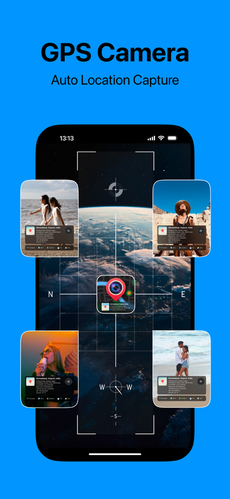
GPS 지도 카메라 앱 인터페이스는 지도 오버레이와 함께 자동 위치 캡처 및 사진 타임스탬프를 표시합니다.
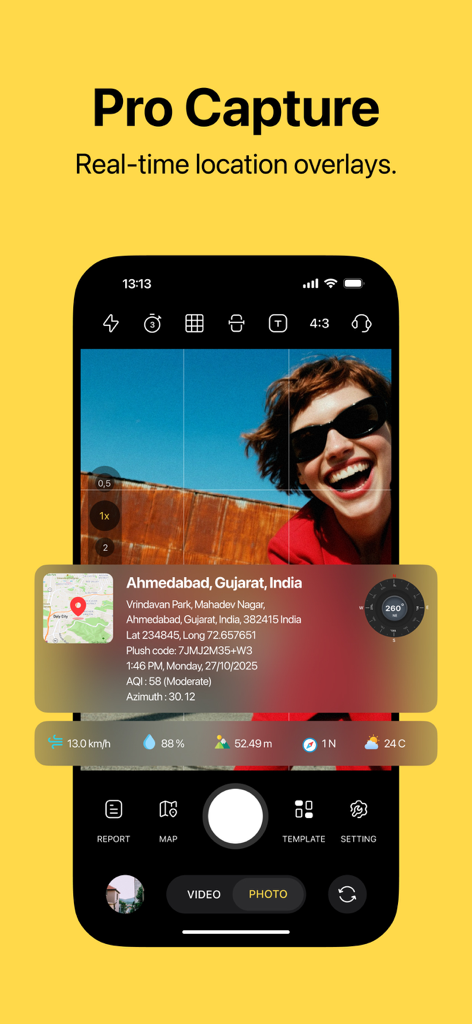
모바일 앱 인터페이스는 실시간 GPS 위치 데이터와 지도 오버레이가 있는 사진을 보여줍니다.
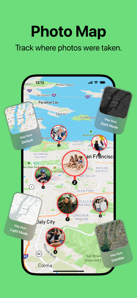
사진을 다양한 지도 스타일 옵션과 함께 지도에 표시하는 사진 지도 기능
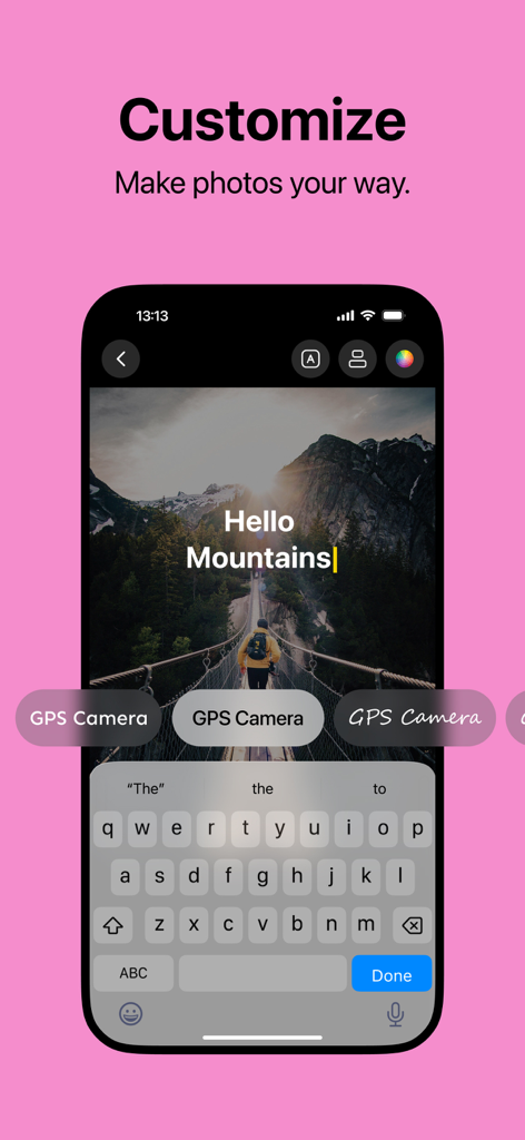
산의 GPS 태그 사진에 글꼴 및 텍스트 사용자 지정 옵션을 보여주는 스마트폰 인터페이스
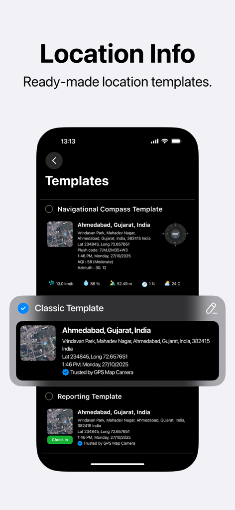
GPS 사진 스탬핑을 위한 미리 만들어진 위치 정보 템플릿을 보여주는 모바일 앱 인터페이스
모든 클릭에 담기는 정밀한 문서화
이 앱을 돋보이게 하는 도구, 8K+ 명의 사용자가 선택.
📍
자동 전문 스탬핑
검사 또는 여행 기록에 대한 부인할 수 없는 작업 증거를 제공하기 위해 GPS 좌표, 정확한 주소 및 시간 정확한 스탬프를 즉시 임베드합니다.
🗺️
통합 지도 오버레이
위성 또는 표준 지도 보기를 이미지에 직접 기록하여 정확한 위치를 시각화하고 모든 촬영에 대한 즉각적인 지리적 맥락을 제공합니다.
📡
현장 준비 오프라인 지원
셀룰러 신호가 없는 원격 '데드 존'에서도 안정적으로 정확한 위치 데이터를 캡처하여 현장에서 문서화가 중단되지 않도록 보장합니다.
앱 소개
에 대해 알아야 할 모든 것 Geo Timestamp : GPS Map Camera.
설명
Capture your moments with accurate location, date, and time details — all in one photo! Geo Timestamp: GPS Map Camera is the ultimate camera app for adding automatic GPS coordinates, map view, date, and time stamps directly on your photos. Whether you’re traveling, working in the field, inspecting a site, or documenting evidence, this app ensures every image tells the full story — where and when it was taken.
Perfect for travelers, engineers, surveyors, real-estate professionals, field workers, and anyone who needs photo timestamping with map location. This all-in-one camera app lets you capture and save photos with precise GPS data and visually stunning map overlays.
Key Features:
• Automatic GPS Location Tag – Every photo you capture includes your current GPS coordinates and address details.
• Date & Time Stamp – Add accurate date and time to each photo automatically for record-keeping and verification.
• Map Overlay View – Show your photo location directly on a map with satellite, hybrid, or standard map styles.
• Custom Watermark Settings – Choose what to display: GPS tag, date, time, address, compass direction, or map view.
• Professional Template Styles – Multiple stamp formats for travel, work reports, field inspections, and social sharing.
• Auto GPS Detection – Fast, reliable, and accurate location detection even in remote areas.
• Manual Location Option – Adjust or select a specific map point if GPS isn’t available.
• Easy Sharing – Instantly share your geo-tagged and timestamped photos through email, chat, or social media.
• Offline Mode Support – Capture and save photos even when internet or GPS signal is weak.
• Organized Gallery View – Quickly access your photo records with date, time, and location summaries.
Best for:
• Travel & Adventure Photography
• Construction & Site Inspections
• Real Estate Property Photos
• Utility & Infrastructure Documentation
• Environmental & Survey Projects
• Field Research & Reports
• Business Audits & Evidence Proof
• Personal Photo Journals & Memories
Why choose Geo Timestamp: GPS Map Camera?
Because every photo should have a story — not just what you captured, but where and when it happened. Whether you’re documenting work progress, recording travel memories, or collecting visual evidence, this app gives you reliable and verifiable photo data instantly.
With one tap, your camera automatically stamps every photo with:
• Latitude & Longitude (GPS Coordinates)
• Address & Map View
• Date & Time
• Compass Direction
• Altitude (if enabled)
Use it as your photo timestamp camera, GPS photo tagging tool, map overlay camera, or date time photo logger.
No more manual edits or missing details — just open the app, snap your photo, and let it handle everything automatically.
Use Cases:
• Inspectors can record site progress with date-time and GPS photo stamps.
• Engineers can capture on-site data with accurate map overlays.
• Real-estate agents can take verified property photos with map location tags.
• Travelers can create visual travel logs with photo locations.
• Field workers can document their visits for reporting and tracking.
App Highlights:
• Simple user interface for all users
• Lightweight and fast GPS camera app
• Supports high-resolution photos
• Works on all iPhone and iPad devices
• Built for both professional and personal use
Whether you want to add timestamp to photos, embed GPS coordinates, show map on photo, or geo-tag your camera shots, this app does it all — automatically and precisely.
Capture your photos with proof.
Every click becomes verifiable, professional, and ready to share.
With Geo Timestamp: GPS Map Camera, your photos become more than just memories — they become powerful records with location and time accuracy.
https://gpstimestampcamera.blogspot.com/2025/08/privacy-policy.html
https://gpstimestampcamera.blogspot.com/2025/08/terms-conditions.html
최신 버전
1.6
크기
47.2 MB
출시일
2025년 9월 1일
모든 사진에 확실한 증거를 담으세요
정확한 GPS 데이터를 사용하여 현장 보고서, 현장 검사 및 여행 기록을 자동화하기 위해 Geo Timestamp를 신뢰하는 수천 명의 전문가 및 모험가와 함께하세요.
FAQ
자주 묻는 질문
에 대해 알아야 할 모든 것 Geo Timestamp : GPS Map Camera
Geo Timestamp: GPS Map Camera란 무엇인가요?
Geo Timestamp: GPS Map Camera는 사진에 자동 GPS 좌표, 지도 보기, 날짜 및 시간 스탬프를 직접 추가하는 카메라 앱입니다. 각 사진이 촬영된 위치와 시간을 캡처합니다.
Geo Timestamp: GPS Map Camera는 사진에 자동으로 GPS 위치를 추가하나요?
예, Geo Timestamp: GPS Map Camera는 캡처된 모든 사진에 현재 GPS 좌표와 주소 정보를 자동으로 추가합니다. 자동 GPS 감지도 지원합니다.
Geo Timestamp: GPS Map Camera는 사진에 날짜 및 시간 스탬프를 추가할 수 있나요?
예, 앱은 기록 보관 및 확인을 위해 각 사진에 정확한 날짜와 시간을 자동으로 추가합니다. 이는 Geo Timestamp 앱의 핵심 기능입니다.
Geo Timestamp: GPS Map Camera는 사진에 지도 오버레이를 제공하나요?
예, Geo Timestamp: GPS Map Camera는 위성, 하이브리드 또는 표준 지도 스타일을 사용하여 사진 위치를 지도에 직접 표시하며 이미지 위에 오버레이됩니다.
Geo Timestamp: GPS Map Camera는 인터넷 또는 GPS 신호 없이 사용할 수 있나요?
예, Geo Timestamp: GPS Map Camera는 오프라인 모드를 지원합니다. 사용자는 인터넷 또는 GPS 신호가 약할 때도 사진을 캡처하고 저장할 수 있습니다.
Geo Timestamp: GPS Map Camera에서 수동으로 위치를 조정할 수 있나요?
예, Geo Timestamp 앱은 수동 위치 옵션을 제공합니다. 사용자는 자동 GPS 감지가 불가능할 경우 특정 지도 지점을 조정하거나 선택할 수 있습니다.
Geo Timestamp: GPS Map Camera에서 사진을 어떻게 공유할 수 있나요?
Geo Timestamp: GPS Map Camera는 간편한 공유를 지원합니다. 사용자는 GPS 태그 및 타임스탬프가 찍힌 사진을 이메일, 채팅 또는 소셜 미디어를 통해 즉시 공유할 수 있습니다.
Geo Timestamp: GPS Map Camera를 누가 사용하면 좋나요?
Geo Timestamp: GPS Map Camera 앱은 여행자, 엔지니어, 측량사, 부동산 전문가 및 사진 타임스탬핑과 지도 위치 및 검증 가능한 데이터가 필요한 현장 작업자에게 이상적입니다.
Geo Timestamp: GPS Map Camera는 위치 정보에 대한 사전 디자인된 템플릿을 제공하나요?
예, 앱은 여행, 작업 보고서 및 현장 검사를 위한 전문 템플릿 스타일을 제공합니다. 탐색 나침반 및 클래식 템플릿과 같은 옵션이 포함됩니다.
Geo Timestamp: GPS Map Camera는 사진에 어떤 정보를 포함하나요?
Geo Timestamp: GPS Map Camera 앱은 사진에 위도 및 경도, 주소 및 지도 보기, 날짜 및 시간, 나침반 방향, 고도(활성화된 경우)를 자동으로 스탬프합니다.
App information, icons, screenshots, and descriptions displayed on this page are sourced from the Apple App Store and are the property of their respective developers. Download estimates and rankings are based on MWM's proprietary models and may not reflect actual figures. This page is provided for informational and analytical purposes only.
Believe this page infringes your intellectual property? File a dispute