이 페이지는 앱이나 개발자의 공식 페이지가 아니며, 정보 제공 및 논평을 목적으로 작성된 독립 편집 간행물입니다. 명시적으로 달리 언급되지 않는 한, 해당 앱이나 개발자는 MWM, Apple, Google Play, 앱 퍼블리셔 또는 앱 개발자와 제휴, 보증, 후원, 승인 또는 공식적으로 연결되어 있지 않으며, 이 페이지의 어떤 내용도 해당 앱이 MWM의 서비스를 사용하여 개발되었음을 의미하지 않습니다. 모든 상표, 로고, 스크린샷 및 기타 콘텐츠는 해당 소유자의 자산입니다.

GeoBallistics
기술 사수를 위한 올인원 생태계. 전문 3 DOF 솔버, 위성으로 매핑된 거리 카드, 원활한 하드웨어 통합을 결합하여 추측을 없애고 모든 사격을 마스터하십시오.
다운로드
8K+사용자 평점
총 평가 수
200개발사
카테고리
Utilities지원 언어
1최신 버전
7.2.9(373)크기
76.5 MB출시일
2015년 8월 25일현대 사수를 위한 정밀 엔지니어링
하드웨어, 기상 데이터 및 위성 이미지를 통합하여 한 발로 정확도를 높이는 전문가 수준의 탄도 생태계로 추측을 없애십시오.
고급 3 DOF 솔버
극한 거리에서 코리올리스 효과, 스핀 드리프트 및 공기 역학적 점프를 고려하여 초정밀 솔루션을 계산합니다.
원활한 하드웨어 동기화
Vortex Razor HD, Kestrel 및 WeatherFlow 장치와 직접 연결하여 실시간 대기 데이터 및 즉각적인 거리 업데이트를 받으십시오.
다음 스크린샷과 설명은 앱의 공식 스토어 목록에서 직접 가져온 것이며 앱 개발자의 자산입니다.
앱 스토어
스크린샷
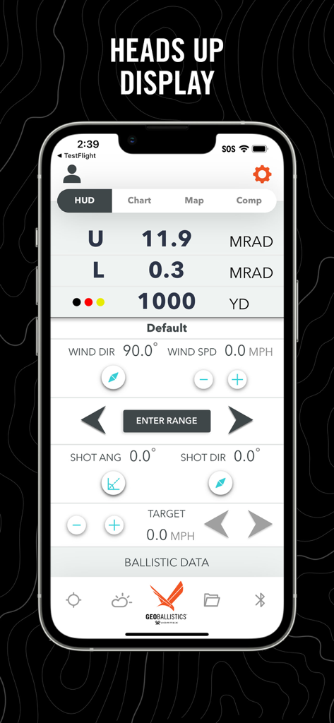
GeoBallistics 앱 헤드업 디스플레이에 탄도 계산 및 표적 거리 표시
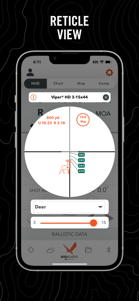
GeoBallistics 앱 망원경 시야에 사슴 표적에 대한 탄도 계산 표시
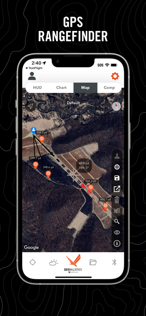
GeoBallistics 앱 GPS 거리 측정기 인터페이스에 거리 핀 및 표적 마커가 있는 위성 이미지 표시
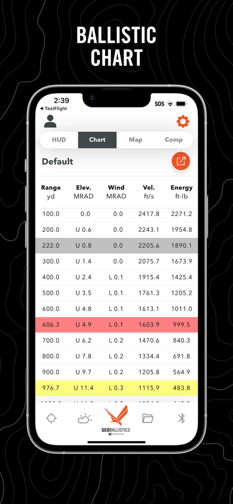
GeoBallistics 앱 스크린샷에 거리, 고도, 풍향, 속도 및 에너지 데이터가 포함된 상세한 탄도 차트 표시
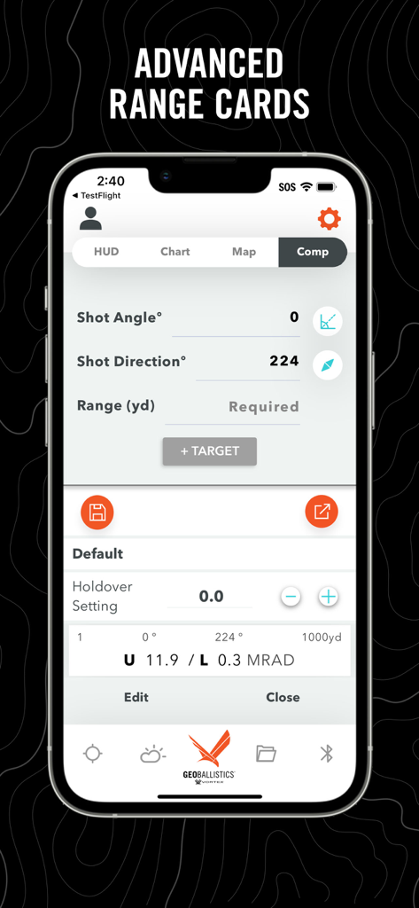
GeoBallistics 앱 인터페이스에 정밀 사격을 위한 Comp Mode의 고급 거리 카드 및 사격 매개변수 표시
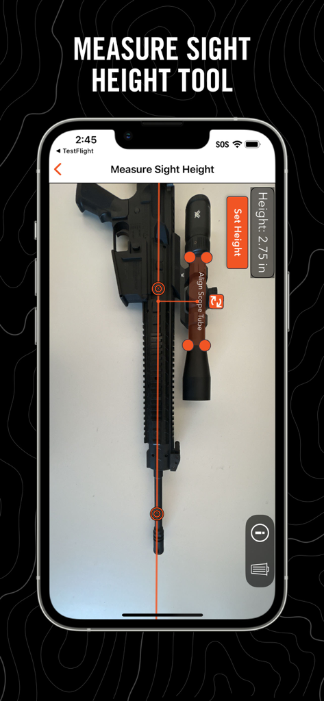
GeoBallistics 앱에 조준경이 있는 라이플에 사용되는 조준 높이 측정 도구 표시
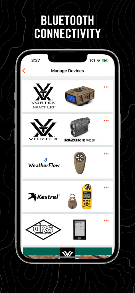
GeoBallistics 앱의 장치 관리 화면에 Vortex 및 Kestrel 하드웨어와의 Bluetooth 연결 표시
설명
Download
비슷한 앱
같은 카테고리의 상위 앱

Google LLC

Google Chrome
Google LLC

中国移动(手机营业厅)
China Mobile Online Services Co., Ltd.

Google Authenticator
Google LLC

CNH do Brasil
Servicos e Informacoes do Brasil

Cleanup: Phone Storage Cleaner
DEEP FLOW SOFTWARE SERVICES - FZCO

gov.br
Servicos e Informacoes do Brasil

中国电信-全国统一官方服务平台
CHINA TELECOM Corporation Ltd.

Microsoft Edge: AI Browser
Microsoft Corporation
이 페이지는 앱이나 개발자의 공식 페이지가 아니며, 정보 제공 및 논평을 목적으로 작성된 독립 편집 간행물입니다. 명시적으로 달리 언급되지 않는 한, 해당 앱이나 개발자는 MWM, Apple, Google Play, 앱 퍼블리셔 또는 앱 개발자와 제휴, 보증, 후원, 승인 또는 공식적으로 연결되어 있지 않으며, 이 페이지의 어떤 내용도 해당 앱이 MWM의 서비스를 사용하여 개발되었음을 의미하지 않습니다. 모든 상표, 로고, 스크린샷 및 기타 콘텐츠는 해당 소유자의 자산입니다.