이 페이지는 앱이나 개발자의 공식 페이지가 아니며, 정보 제공 및 논평을 목적으로 작성된 독립 편집 간행물입니다. 명시적으로 달리 언급되지 않는 한, 해당 앱이나 개발자는 MWM, Apple, Google Play, 앱 퍼블리셔 또는 앱 개발자와 제휴, 보증, 후원, 승인 또는 공식적으로 연결되어 있지 않으며, 이 페이지의 어떤 내용도 해당 앱이 MWM의 서비스를 사용하여 개발되었음을 의미하지 않습니다. 모든 상표, 로고, 스크린샷 및 기타 콘텐츠는 해당 소유자의 자산입니다.
GPS Land Measurement & Survey
건설업자, 농부, 토지 소유자에게 필수적인 도구입니다. GPS 정확도로 에이커 면적을 측정하고, 필지 경계를 매핑하며, 거리를 계산하세요. 오프라인 및 가장 외딴 지역에서도 사용할 수 있습니다.
주요 수치
다운로드
561K+
사용자 평점
4.5/5
총 평가 수
6K+
개발사
LOGISIAN TECHNOLOGY SOLUTIONS PRIVATE LIMITED
카테고리
Utilities
지원 언어
1
최신 버전
10.3.3
크기
58.3 MB
출시일
2013년 1월 25일
기능
모든 에이커를 위한 전문가용 현장 도구
모바일 장치를 고정밀 측량 도구로 변환하세요. Mapulator는 건설업자, 농부, 토지 소유자가 자신 있게 필지를 관리하는 데 필요한 정확도와 데이터 무결성을 제공합니다.
정밀 면적 및 둘레 매핑
모든 지형에 대한 정확한 평방 피트 또는 에이커 면적을 계산합니다. 전문 표준 및 프로젝트 요구 사항에 맞게 미터법과 야드파운드법 단위를 즉시 전환할 수 있습니다.
실시간 GPS 추적 및 오프라인 지원
실시간으로 경계를 측정하기 위해 필지 경계를 따라 걸으세요. 안정적인 오프라인 지도는 외딴 시골 지역이나 신규 건설 현장에서 작업하는 동안 진행 상황을 잃지 않도록 합니다.
다음 스크린샷과 설명은 앱의 공식 스토어 목록에서 직접 가져온 것이며 앱 개발자의 자산입니다.
앱 스토어
스크린샷
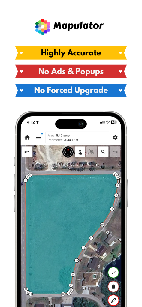
Mapulator 앱 인터페이스가 위성 지도에서 5에이커의 토지 면적을 측정하고 있습니다.
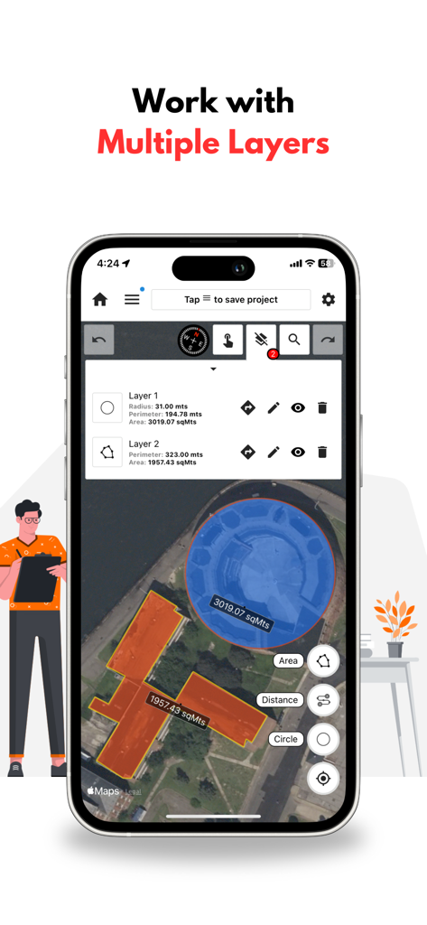
GPS 토지 측정 앱 인터페이스가 지도에서 원형 및 다각형 면적 측정을 위한 여러 레이어를 보여줍니다.
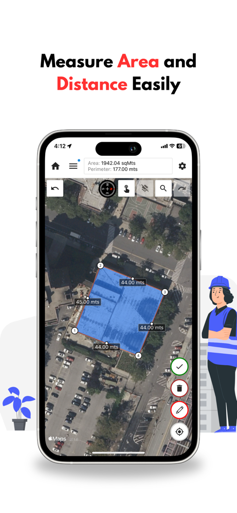
Mapulator 앱 인터페이스가 위성 지도에서 토지 면적 및 둘레 측정을 보여줍니다.
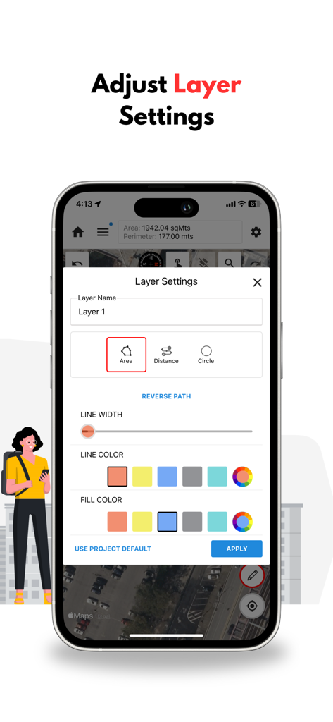
스마트폰 화면이 Mapulator 앱 레이어 설정 메뉴를 보여주며 지도 색상 및 스타일을 사용자 지정합니다.
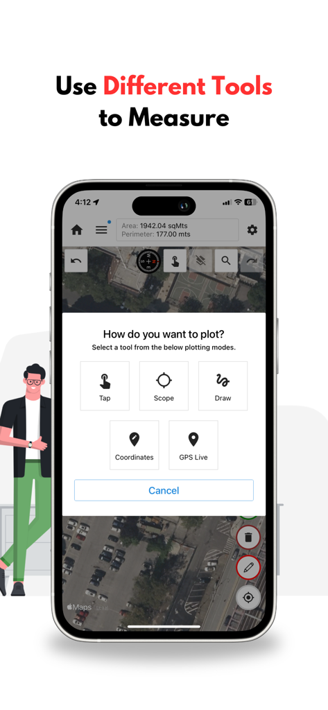
Mapulator 앱 인터페이스가 토지 측정을 위해 위성 지도 위에서 탭, 스코프, 그리기, GPS 라이브와 같은 다양한 플로팅 도구를 보여줍니다.
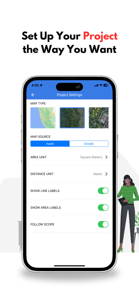
Mapulator 앱에서 지도 유형 및 측정 단위 옵션과 함께 프로젝트 설정을 보여주는 인터페이스.
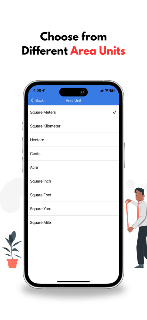
스마트폰 화면에 Mapulator 앱에서 에이커, 헥타르, 제곱피트와 같은 다양한 면적 측정 단위 목록이 표시됩니다.
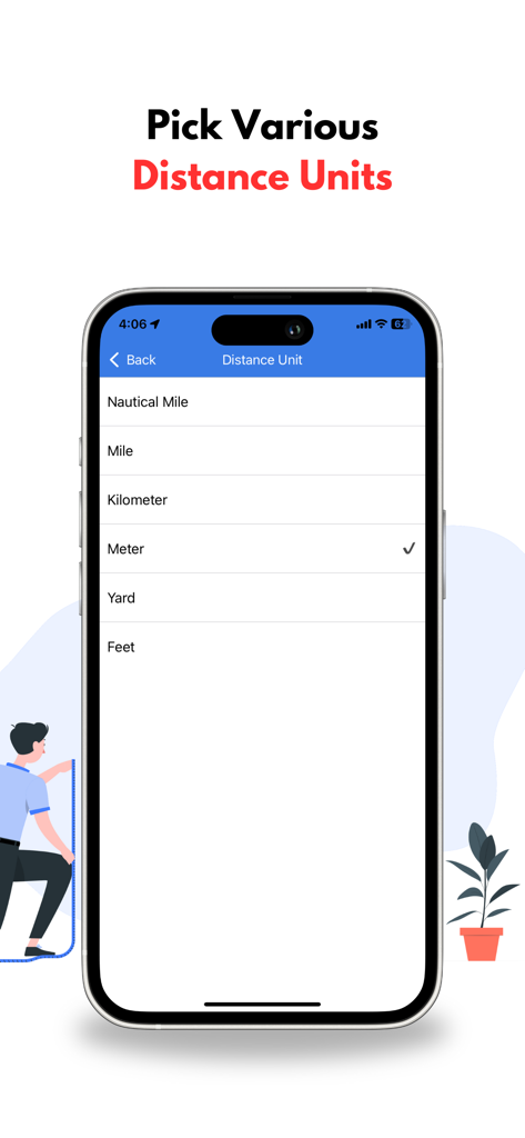
인터페이스에 마일, 킬로미터, 미터를 포함한 거리 단위 선택이 표시됩니다.
Mapulator 앱 화면이 KML 및 GeoJSON 파일에 대한 프로젝트 공유 및 내보내기 옵션을 보여줍니다.
위성 지도에 색상으로 구분된 토지 측정이 표시된 Mapulator 웹 인터페이스를 보여주는 노트북 화면.
설명
GPS Area Measure - Mapulator is a powerful measurement app for iPhone designed for professionals and individuals who need field area measurements, GPS measure distance, and land surveying tools. Whether you're working in land survey, property lines mapping, fieldmaps, or need a distance calculator for land navigation, this app provides quick and accurate results.
Accurate GPS-Based Land and Distance Measurement
Turn your iPhone into a digital tape measure and map maker with precise area measurement, radius map, and measure angles capabilities. Ideal for roof, room measurements, and land measurement calculations, Mapulator helps you get the most out of your measurements.
Key Features:
• Multiple Measurement Tools – Measure land area, perimeter, distance, and radius map with precision.
• GPS Live Mode – Walk or move to measure distance in real time.
• Multiple Units Supported – Work with meters, acres, hectares, and more.
• Customizable Maps – Use land maps, field maps, and terrain views for better accuracy.
• Advanced Calculation Tools – Includes an area calculator, measurement calculator, and measure angles tool.
• Undo/Redo Feature – Easily correct measurements without restarting.
• Search & Export – Find locations quickly and export data in KML or GeoJSON.
• Offline Support – Access field area measure tools even without an internet connection.
Why Choose Mapulator?
• Highly Accurate GPS Measure Distance – Get reliable land surveying results.
• User-Friendly Interface – Easy to use for professionals and beginners.
• Versatile Application – Ideal for roof measure, room measurement, property lines mapping, and more.
• Free Measuring App Features – Access essential tools in the measure-free version.
Who Can Benefit?
• Surveyors & Engineers – Conduct land surveying with field area measure accuracy.
• Farmers & Landowners – Use land map tools to measure and calculate property lines.
• Construction Professionals – Plan projects with a measurement calculator for roof and room measurement.
• Outdoor Enthusiasts – Navigate with land navigation and GPS measure distance features.
Welcome to GPS Area Measure by Mapulator! We're an ecstatic mapping tool for precise area, perimeter, and distance calculations. Whether you're a seasoned professional or just exploring your surroundings, Mapulator empowers you with accurate measurements at your fingertips.
Dive into a world of seamless mapping and precise calculations. Explore our intuitive interface and discover the power of real-time GPS measurement, customizable map views, and versatile measurement tools. From land surveying and agricultural planning to construction management and outdoor adventures, Mapulator is your trusted companion for all your measurement needs.
How to Use the App?
1. Select a Measurement Tool – Choose from area measure, measure distance, or radius map.
2. Mark Points on the Map – Use the interactive map maker to outline areas.
3. Customize Settings – Adjust map layers for field map visualization.
4. Enable GPS Live Mode – Measure distance tracking on the go with GPS.
5. Save & Export – Store and share your land map and measurements.
Accurately measure areas, perimeters, and distances on maps with GPS Area Measure by Mapulator. Perfect for land measurement, agriculture, surveying, construction, and more.
Precise Mapping Tool for Professionals & Enthusiasts
Mapulator is the ultimate mapping tool for professionals and enthusiasts. Whether you're a land surveyor, real estate agent, farmer, construction manager, or simply curious about your surroundings, Mapulator provides the precision and flexibility you need. Easily calculate areas, distances, and radii directly on the map, transforming your mobile device into a powerful measurement instrument.
Download Now
Get GPS Area Measure - Mapulator, the free measuring app that simplifies land surveying, distance calculations, and area measurements for iPhone users.
이 페이지는 앱이나 개발자의 공식 페이지가 아니며, 정보 제공 및 논평을 목적으로 작성된 독립 편집 간행물입니다. 명시적으로 달리 언급되지 않는 한, 해당 앱이나 개발자는 MWM, Apple, Google Play, 앱 퍼블리셔 또는 앱 개발자와 제휴, 보증, 후원, 승인 또는 공식적으로 연결되어 있지 않으며, 이 페이지의 어떤 내용도 해당 앱이 MWM의 서비스를 사용하여 개발되었음을 의미하지 않습니다. 모든 상표, 로고, 스크린샷 및 기타 콘텐츠는 해당 소유자의 자산입니다.