이 페이지는 앱이나 개발자의 공식 페이지가 아니며, 정보 제공 및 논평을 목적으로 작성된 독립 편집 간행물입니다. 명시적으로 달리 언급되지 않는 한, 해당 앱이나 개발자는 MWM, Apple, Google Play, 앱 퍼블리셔 또는 앱 개발자와 제휴, 보증, 후원, 승인 또는 공식적으로 연결되어 있지 않으며, 이 페이지의 어떤 내용도 해당 앱이 MWM의 서비스를 사용하여 개발되었음을 의미하지 않습니다. 모든 상표, 로고, 스크린샷 및 기타 콘텐츠는 해당 소유자의 자산입니다.

GPS-Tracker Pro
데이터 중심 탐험가를 위한 고급 유틸리티. 고충실도 측정값, 동적 속도 지도 및 전문 등급 GPX, KML 또는 CSV 내보내기를 통해 모든 등산, 운전 및 비행을 기록하세요.
다운로드
374K+사용자 평점
총 평가 수
200개발사
카테고리
Navigation지원 언어
2최신 버전
1.8크기
1.9 MB출시일
2015년 7월 17일모든 여정을 위한 정밀 추적
산길에서 비행 경로까지, 전문 등급 GPS 로깅 및 고급 데이터 시각화를 통해 활동의 모든 세부 정보를 캡처하세요.
포괄적인 데이터 인사이트
실시간 속도, 고도 및 거리를 정밀한 통계로 모니터링하여 모든 활동에서의 성과를 분석하는 데 도움을 줍니다.
시각적 속도 매핑
속도 변화를 지도에 직접 표시하는 동적 다채널 경로를 통해 속도를 시각화합니다.
다음 스크린샷과 설명은 앱의 공식 스토어 목록에서 직접 가져온 것이며 앱 개발자의 자산입니다.
앱 스토어
스크린샷
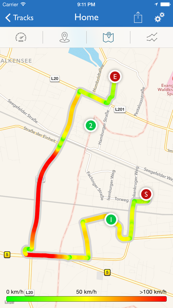
GPS-Tracker Pro 앱의 지도에 표시된 다채널 경로 추적으로, 경로를 따라 속도 변화를 나타냅니다.
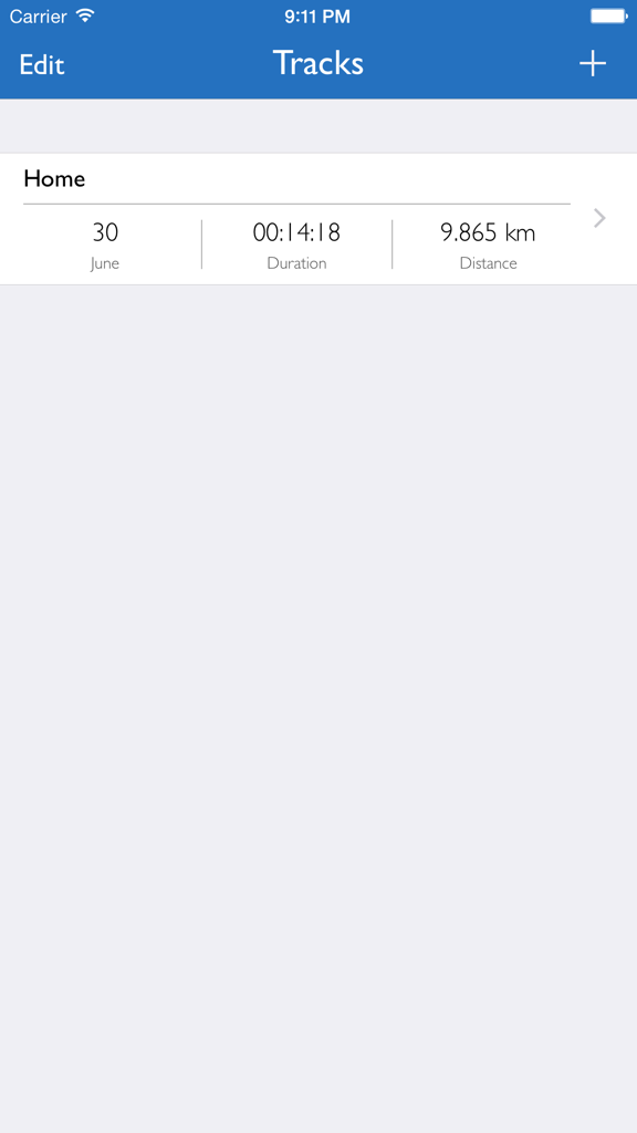
GPS-Tracker Pro 앱의 인터페이스로, 기간 및 거리를 포함한 여행 세부 정보가 포함된 기록된 GPS 추적 목록을 보여줍니다.
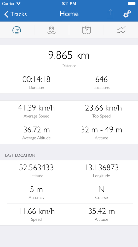
GPS-Tracker Pro 대시보드로, 거리, 속도, 고도 및 지리 좌표 추적 데이터를 표시합니다.
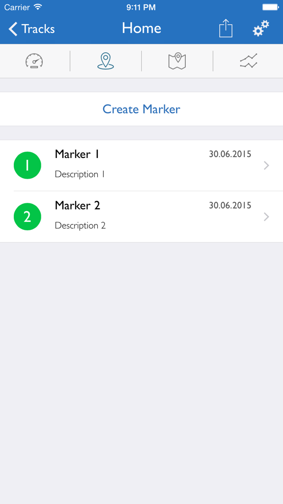
GPS-Tracker Pro 화면으로, 날짜와 설명이 포함된 사용자 지정 위치 마커 목록을 표시합니다.
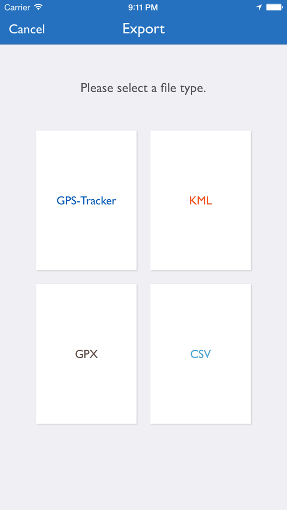
GPS-Tracker Pro의 내보내기 인터페이스로, KML, GPX 및 CSV 파일 형식 선택 옵션을 보여줍니다.
설명
Download
비슷한 앱
같은 카테고리의 상위 앱

Google Maps
Google LLC

Waze Navigation & Live Traffic
waze

AMap Global
AutoNavi Information Technology Co. Ltd.

百度地图-路线规划,出行必备
Beijing Baidu Netcom Science & Technology Co.,Ltd

Moovit: Bus & Transit Tracker
Moovit App Global LTD

Transit • Subway & Bus Times
9280-0366 Quebec inc.

ParkMobile: Park. Pay. Go.
Parkmobile USA, Inc

腾讯地图-路线规划,导航地铁打车出行
Shenzhen Tencent Computer Systems Company Limited

Île-de-France Mobilités
Ile de France Mobilites
이 페이지는 앱이나 개발자의 공식 페이지가 아니며, 정보 제공 및 논평을 목적으로 작성된 독립 편집 간행물입니다. 명시적으로 달리 언급되지 않는 한, 해당 앱이나 개발자는 MWM, Apple, Google Play, 앱 퍼블리셔 또는 앱 개발자와 제휴, 보증, 후원, 승인 또는 공식적으로 연결되어 있지 않으며, 이 페이지의 어떤 내용도 해당 앱이 MWM의 서비스를 사용하여 개발되었음을 의미하지 않습니다. 모든 상표, 로고, 스크린샷 및 기타 콘텐츠는 해당 소유자의 자산입니다.