이 페이지는 앱이나 개발자의 공식 페이지가 아니며, 정보 제공 및 논평을 목적으로 작성된 독립 편집 간행물입니다. 명시적으로 달리 언급되지 않는 한, 해당 앱이나 개발자는 MWM, Apple, Google Play, 앱 퍼블리셔 또는 앱 개발자와 제휴, 보증, 후원, 승인 또는 공식적으로 연결되어 있지 않으며, 이 페이지의 어떤 내용도 해당 앱이 MWM의 서비스를 사용하여 개발되었음을 의미하지 않습니다. 모든 상표, 로고, 스크린샷 및 기타 콘텐츠는 해당 소유자의 자산입니다.
iHikeGPS : Classic Topo Maps
상세한 USGS 및 USFS 쿼드 지도로 기기를 고성능 GPS 수신기로 전환하세요. 구독료, 광고, 셀 신호 필요 없음—진정한 탐험가를 위한 전문가급 내비게이션입니다.
주요 수치
다운로드
158K+
사용자 평점
4.0/5
총 평가 수
200
개발사
James Associates Inc.
카테고리
Navigation
지원 언어
1
최신 버전
9.6.6
크기
12.1 MB
출시일
2010년 2월 12일
기능
진정한 오지 탐험가를 위한 맞춤 제작
구독료 없이 단 한 번의 평생 가격으로 전문가급 USGS 토포그래픽 쿼드, 고급 트랙 녹음 및 개인 정보를 최우선으로 생각하는 경험을 제공합니다.
클래식 래스터 토포 쿼드
최신 벡터 지도에서 종종 누락되는 숨겨진 샘, 오래된 도로 및 지형의 상세 정보를 보여주는 고해상도 USGS 및 US 산림청 지도를 이용하세요.
구독료 없음, 언제나
한 번의 저렴한 가격으로 평생 이용할 수 있습니다. 가입, 광고, 현장에서 도구를 계속 사용할 수 있도록 하는 반복 요금 없이 귀하의 개인 정보를 존중합니다.
다음 스크린샷과 설명은 앱의 공식 스토어 목록에서 직접 가져온 것이며 앱 개발자의 자산입니다.
앱 스토어
스크린샷
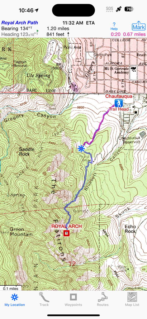
iHikeGPS 앱 화면, 기록된 하이킹 경로 및 내비게이션 데이터가 있는 클래식 USGS 토포그래픽 지도 표시
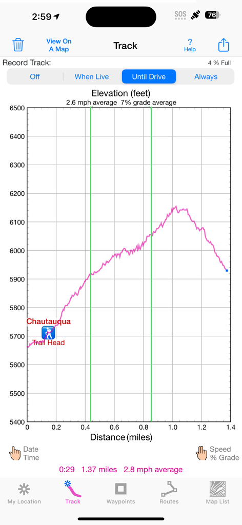
피트 단위의 높이와 마일 단위의 거리를 보여주는 하이킹 트랙의 고도 프로필 그래프
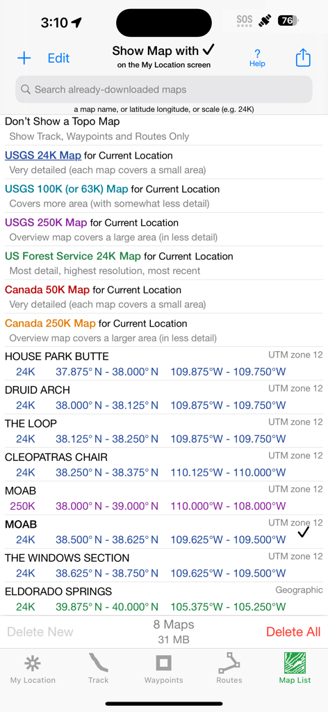
다운로드된 지도에 대한 USGS 및 캐나다 토포 지도 옵션과 기술 좌표를 보여주는 iHikeGPS의 지도 목록 화면
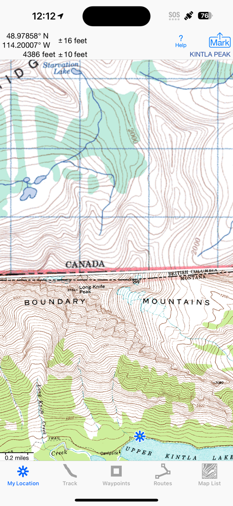
미국-캐나다 국경의 상세한 클래식 토포그래픽 지도를 고도 및 GPS 좌표와 함께 보여주는 iHikeGPS 앱 인터페이스
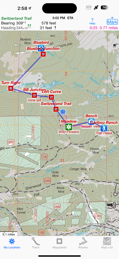
iHikeGPS 앱 인터페이스, 하이킹 경로 및 웨이포인트가 있는 상세한 클래식 토포그래픽 지도 표시
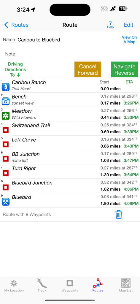
거리와 예상 도착 시간을 포함한 웨이포인트 목록을 보여주는 iHikeGPS 경로 화면
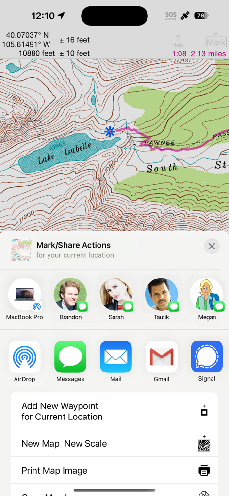
iHikeGPS 앱 인터페이스, 공유 및 웨이포인트 옵션이 있는 Isabella 호수의 상세한 토포 지도 표시
iHikeGPS의 Blue Lake 트레일에 대한 거리 및 고도 상승을 보여주는 상세한 하이킹 경로 고도 프로필
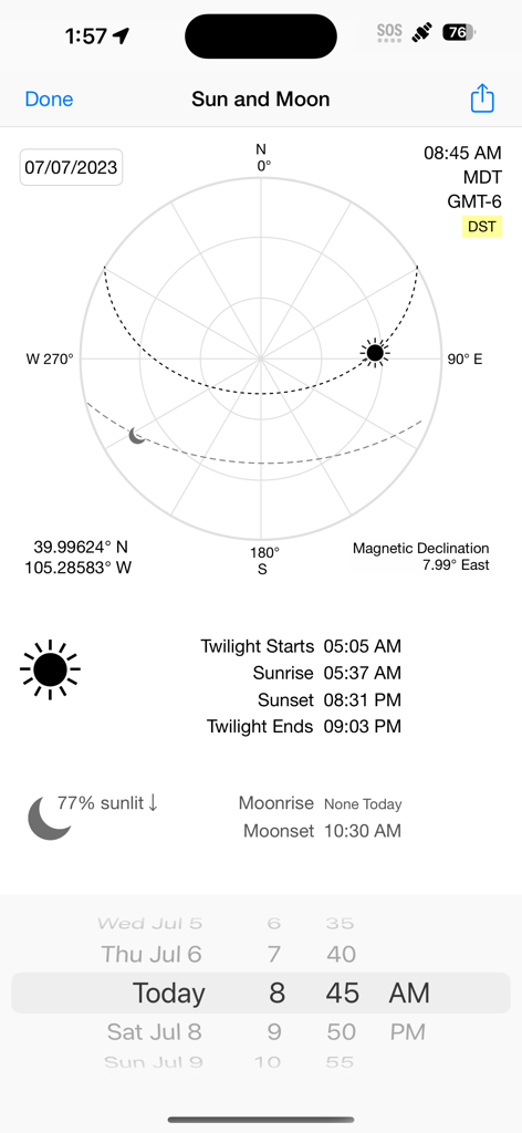
iHikeGPS 앱 화면, 태양 및 달 위치, 일출 및 일몰 시간, 좌표 및 자기 편차 표시
설명
Unleash the navigation potential of your iPhone or iPad with iHikeGPS! Turn your device into a high-performance GPS receiver equipped with USGS, US Forest Service & Canadian topo maps. These Classic topo map quads often have valuable back country details that vector maps in other hiking apps don't show.
Even in remote areas with no cell signal, iHikeGPS ensures you always know where you've been, where you are, and where you’re going. Experience the ultimate hiking companion, offering unparalleled Track recording, Route navigation & accurate Estimated Time of Arrival.
One Low Price! Everything included. No sign-ups, ads, subscriptions or in-app purchases. Completely respects your privacy.
Discover the limitless possibilities of iHikeGPS while hiking, backpacking, biking, geocaching, camping, sightseeing, 4 wheeling, skiing & hunting. Recommended as the top choice in “Essential Gear for Safe Hiking”, it's a must-have for outdoor enthusiasts.
TRACKS, WAYPOINTS & ROUTES
Record Tracks as you hike, even in the background. View them on the map with a Trip Timer & Odometer.
View elevation graphs of your Tracks & Routes. Show date, time, % grade, average speed and the area inside a closed path.
Mark Waypoints precisely using topo or satellite maps, place names or addresses, geotagged photos, or by projecting from a known point. Get the elevation from a Digital Elevation Model database.
Set a quick GoTo Waypoint or a full Route to see the heading, direction, distance, elevation change & Estimated Time of Arrival at your destination & intermediate Waypoints along the trail. Be warned when you leave a Route you were following.
Create customized Routes using Waypoints, recorded Tracks, or imported GPX, KML or TCX files. Advanced Route editing.
Send Waypoint, Route, Track & Map List files to other apps and other people via AirDrop, eMail, Messages or iCloud Drive.
View the sun & moon positions and rise & set times for any date & place.
TOPO MAPS AT NO EXTRA COST
US Forest Service FSTopo 24K maps
USGS 24K maps for all states, Guam, Puerto Rico & the US Virgin Islands
USGS 250K & 100K (63K for Alaska) maps for all states
National Resources Canada 50K maps for all areas south of 50° latitude. For Alberta, British Columbia & Newfoundland coverage extends to 54°.
Download using WiFi or cell service. Our maps are optimized to download faster & use less storage memory. Store up to 2200 maps to use in the wilderness without cell service.
These beautiful richly detailed offline topographic map images stitch together for seamless coverage across map boundaries.
Print & Share map images overlaid with Waypoints, Routes & Tracks.
Measure distance and direction between any 2 points.
USE THE UNITS YOU PREFER
Miles, Nautical miles or Km
Feet or Meters
Degrees, Degrees/Minutes, Degrees/Minutes/Seconds, UTM or USNG-MGRS
°True or °Magnetic
SUPPORT
Comprehensive Help in the App
Online Manual on iHikeGPS.com
Email developer: lwjames@iHikeGPS.com
WHAT OTHERS SAY
“I am VERY impressed!!!…It pretty much blows…, my previous fave GPS app, out of the water. Your track recording features, fast map downloads, and well thought out interface make it a real winner.”-John in OR
“Perfect for anyone camping, fishing & hiking, it'll provide great detail when you need it the most…for anyone who takes the great outdoors seriously”-David's review
"iHike is the best user interface ever."-Larry B
“Thanks for a wonderful and inexpensive app! I see my climbing buddies using expensive subscription apps that don't seem to be better.”-Charles
DEVICE REQUIREMENTS
Use iHikeGPS on any iOS device even if you don't have a cellular data plan. iPhones & WiFi+cellular iPads support full navigation. WiFi-only iPads can view maps, but require an iOS-compatible external GPS receiver to show your location & record tracks.
Join thousands of satisfied users who rely on iHikeGPS for their outdoor adventures!
이 페이지는 앱이나 개발자의 공식 페이지가 아니며, 정보 제공 및 논평을 목적으로 작성된 독립 편집 간행물입니다. 명시적으로 달리 언급되지 않는 한, 해당 앱이나 개발자는 MWM, Apple, Google Play, 앱 퍼블리셔 또는 앱 개발자와 제휴, 보증, 후원, 승인 또는 공식적으로 연결되어 있지 않으며, 이 페이지의 어떤 내용도 해당 앱이 MWM의 서비스를 사용하여 개발되었음을 의미하지 않습니다. 모든 상표, 로고, 스크린샷 및 기타 콘텐츠는 해당 소유자의 자산입니다.