이 페이지는 앱이나 개발자의 공식 페이지가 아니며, 정보 제공 및 논평을 목적으로 작성된 독립 편집 간행물입니다. 명시적으로 달리 언급되지 않는 한, 해당 앱이나 개발자는 MWM, Apple, Google Play, 앱 퍼블리셔 또는 앱 개발자와 제휴, 보증, 후원, 승인 또는 공식적으로 연결되어 있지 않으며, 이 페이지의 어떤 내용도 해당 앱이 MWM의 서비스를 사용하여 개발되었음을 의미하지 않습니다. 모든 상표, 로고, 스크린샷 및 기타 콘텐츠는 해당 소유자의 자산입니다.
iHikeGPS NZ : LINZ Topo Maps
진지한 하이커와 여행자를 위한 최고의 도구입니다. 100% 오프라인 신뢰성을 갖춘 고성능 GPS 내비게이션을 경험하세요. 한 번의 가격, 구독 없음, 광고 없음—순수한 오지 안전만 제공합니다.
주요 수치
다운로드
153K+
사용자 평점
3.8/5
총 평가 수
100
개발사
James Associates Inc.
카테고리
Navigation
지원 언어
1
최신 버전
9.6.6
크기
10.6 MB
출시일
2011년 12월 22일
기능
진지한 탐험가를 위한 엔지니어링
구독이나 추적 없이 뉴질랜드의 가장 외딴 오지를 위해 설계된 공식 LINZ 지형도와 고급 GPS 기능을 갖춘 전문가 수준의 내비게이션을 이용하세요.
공식 오프라인 지형도
모든 곳에서 고해상도 LINZ 50K 지형도에 액세스하세요. 셀 신호가 없고 비싼 데이터 로밍 요금 없이 깊은 계곡과 외딴 산맥에서 끊김 없이 탐색하세요.
정확한 경로 정보
실시간 예상 도착 시간, 고도 프로필, 경로 이탈 경고로 안전을 유지하세요. iPhone을 생명 구조 장치로 바꾸는 고성능 GPS 도구로 진행 상황을 추적하세요.
다음 스크린샷과 설명은 앱의 공식 스토어 목록에서 직접 가져온 것이며 앱 개발자의 자산입니다.
앱 스토어
스크린샷
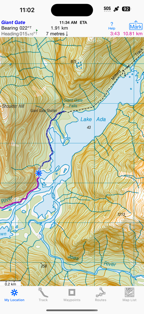
iHikeGPS NZ 앱의 Lake Ada 근처 Milford Track의 지형도 표시
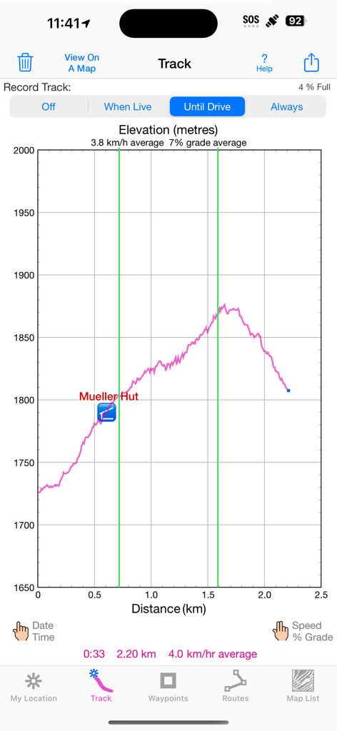
iHikeGPS NZ 앱에서 Mueller Hut까지의 하이킹에 대한 거리와 고도를 보여주는 고도 프로필 그래프.
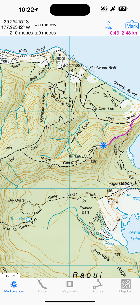
iHikeGPS NZ 앱에서 하이킹 경로와 GPS 좌표를 보여주는 상세한 LINZ 지형도 인터페이스.
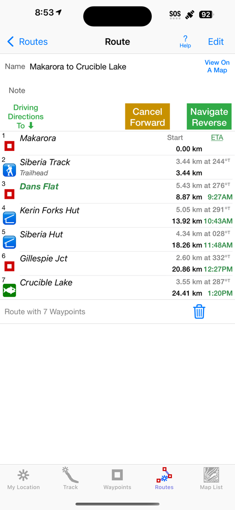
Makarora에서 Crucible Lake까지의 하이킹에 대한 경유지와 예상 도착 시간을 보여주는 iHikeGPS NZ 앱 경로 화면
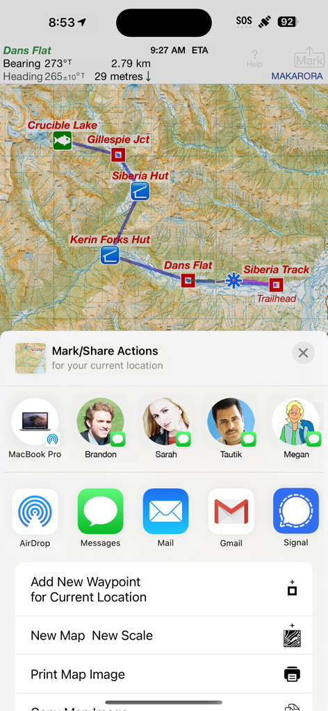
iHikeGPS NZ의 뉴질랜드 지형도로, 공유 및 마크 작업 메뉴가 열려 있습니다.
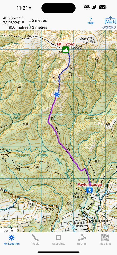
Mt Oxford 근처의 하이킹 경로를 보여주는 상세한 뉴질랜드 지형도
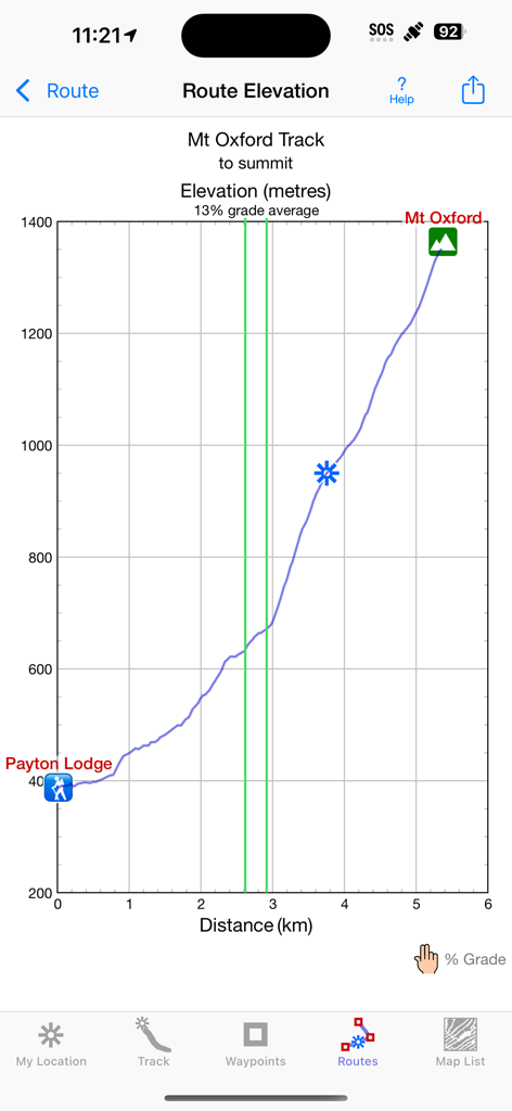
iHikeGPS NZ 앱의 Mt Oxford Track 경로 고도 프로필 그래프
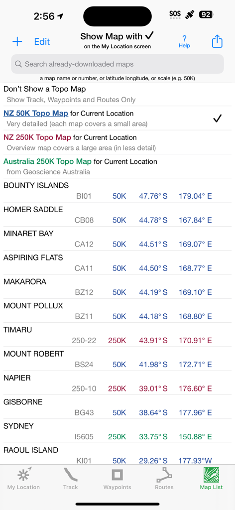
iHikeGPS NZ 앱에서 축척 및 좌표가 표시된 공식 뉴질랜드 및 호주 지형도 목록을 표시하는 화면.
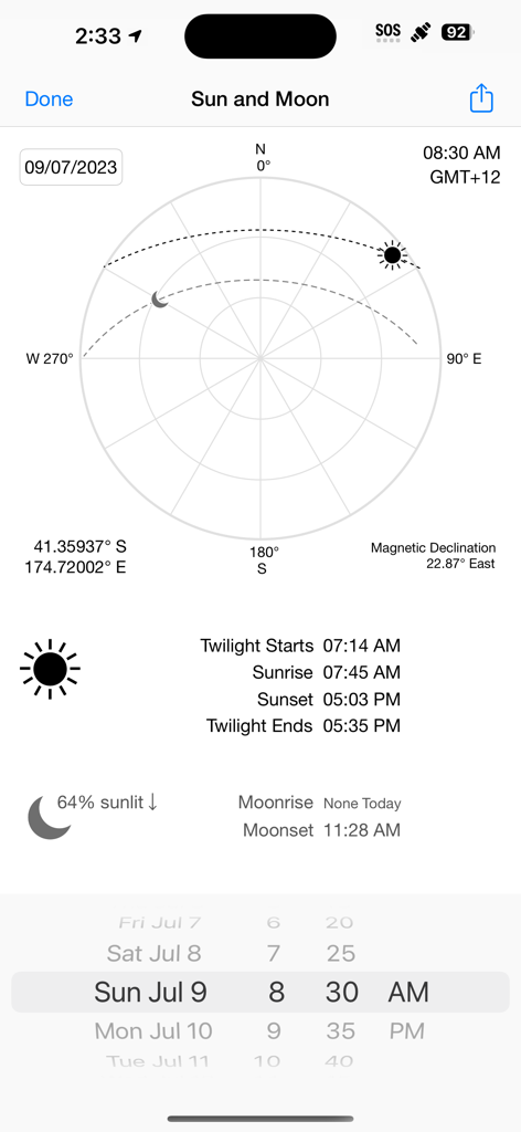
iHikeGPS NZ 앱의 일월 위치, 일출 및 일몰 시간, 자기 편차를 표시하는 스크린샷.
설명
Unleash the navigation potential of your iPhone or iPad with iHikeGPS NZ! Turn your device into a high-performance GPS receiver with the official LINZ New Zealand topo maps. These maps have many valuable back country details to keep you informed and safe.
Even in remote areas with no cell signal, iHikeGPS NZ ensures you always know where you've been, where you are, and where you’re going. Experience the ultimate hiking companion, offering unparalleled track recording, route navigation, and accurate Estimated Time of Arrival.
One Low Price! Everything included. No sign-ups, ads, subscriptions or in-app purchases. Completely respects your privacy.
Discover the limitless possibilities of iHikeGPS for walking, hiking, trekking, tramping, running, biking, backpacking, canoeing, kayaking, geocaching, camping, sightseeing, 4 wheeling, skiing & hunting, .
TRACKS, WAYPOINTS & ROUTES
Record Tracks as you walk, even in the background. View them on the map with a Trip Timer and Odometer.
View elevation graphs of your Tracks and Routes. Show date, time, average speed, % grade & the area inside a closed path.
Mark Waypoints precisely using topo or satellite maps, place names or addresses, geotagged photos or by projecting from a known point.
Get the elevation above sea level for any location from a Digital Elevation Model database.
Set a quick GoTo Waypoint or a full Route & see the heading, direction, distance, elevation change and Estimated Time of Arrival at your destination and at intermediate waypoints along the trail. Be warned when you leave a Route you were following.
Create customized routes using Waypoints, recorded Tracks, or imported GPX, KML or TCX files.
Advanced Route editing.
Send GPX and KML Waypoint, Route, Track and Map List files via AirDrop, eMail, Messages, or iCloud Drive.
View the sun & moon positions and rise & set times for any date & place.
Send data to other apps such as Google Earth.
TOPO MAPS AT NO EXTRA COST
The latest up to date version of official Land Information New Zealand (LINZ) 50K & 250K scale topo maps, including NZ off-shore islands.
Free Bonus: Official Geoscience Australia 250K scale maps. (No smaller scale maps for Australia).
Download using WiFi or cell service. Our maps are optimized to download faster and use less storage memory. Store a few maps or all maps for both countries to use in the wilderness without cell service.
These beautiful richly detailed high resolution offline topographic map images stitch together for seamless coverage across map boundaries.
Includes map legends.
Print and Share map images overlaid with Waypoints, Routes and Tracks.
Measure distance and direction between any 2 points.
USE THE UNITS YOU PREFER
Kilometers, Miles, or Nautical Miles.
Meters or Feet.
Degrees, Degrees/Minutes, Degrees/Minutes/Seconds, UTM, or NZTM2000 grid.
°True or °Magnetic.
HOW TOS
Comprehensive Help in the App
Online Manual on iHikeGPS.com/nz
Email developer: lwjames@iHikeGPS.com
WHAT OTHERS SAY
“This app saved my life! *****
This app was downloaded, while lost in the Kaimai Ranges. GPS quickly located position, app quickly (ish) downloaded the relevant NZ topo map. From there easily identified position on the map. Outcome, life saved. And my mates who by this stage was getting all girly about it all. Best app ever!!!” - Jk9624 on the UK App Store
“I have used your ihike app for many years tramping in NZ. It is fantastic and absolutely the best off line navigation app out there.” - Paul, an internationally-known documentary film maker in Wanaka, New Zealand
DEVICE REQUIREMENTS
Use iHikeGPS NZ on any iOS device even if you don't have a cellular data plan for it. iPhones and WiFi+cellular iPads support full navigation. WiFi-only iPads and iPod touches can view maps, but require an iOS-compatible external GPS receiver to show your location and record tracks.
Join thousands of satisfied users who rely on iHikeGPS NZ for their outdoor adventures!
이 페이지는 앱이나 개발자의 공식 페이지가 아니며, 정보 제공 및 논평을 목적으로 작성된 독립 편집 간행물입니다. 명시적으로 달리 언급되지 않는 한, 해당 앱이나 개발자는 MWM, Apple, Google Play, 앱 퍼블리셔 또는 앱 개발자와 제휴, 보증, 후원, 승인 또는 공식적으로 연결되어 있지 않으며, 이 페이지의 어떤 내용도 해당 앱이 MWM의 서비스를 사용하여 개발되었음을 의미하지 않습니다. 모든 상표, 로고, 스크린샷 및 기타 콘텐츠는 해당 소유자의 자산입니다.