이 페이지는 앱이나 개발자의 공식 페이지가 아니며, 정보 제공 및 논평을 목적으로 작성된 독립 편집 간행물입니다. 명시적으로 달리 언급되지 않는 한, 해당 앱이나 개발자는 MWM, Apple, Google Play, 앱 퍼블리셔 또는 앱 개발자와 제휴, 보증, 후원, 승인 또는 공식적으로 연결되어 있지 않으며, 이 페이지의 어떤 내용도 해당 앱이 MWM의 서비스를 사용하여 개발되었음을 의미하지 않습니다. 모든 상표, 로고, 스크린샷 및 기타 콘텐츠는 해당 소유자의 자산입니다.

Light Pollution Map - Dark Sky
가장 어두운 하늘을 찾고, 실시간 오로라를 추적하며, 밤하늘을 탐험하세요. 별 관측가, 사진작가, 야외 탐험가를 위한 올인원 정밀 도구입니다.
다운로드
611K+사용자 평점
총 평가 수
1K+개발사
카테고리
Weather지원 언어
1최신 버전
5.5.0크기
95.6 MB출시일
2017년 2월 17일밤하늘을 정복하는 데 필요한 모든 것
가장 어두운 캠핑 장소를 찾고 오로라를 추적하는 것까지, 최고의 별 관측 경험을 위한 정밀 데이터를 제공합니다.
대화형 어둠의 하늘 지도
사진 촬영 및 관측에 가장 맑고 어두운 하늘을 고해상도 광공해 데이터로 찾아보세요. 당신의 다음 탈출을 위해 맞춤 제작되었습니다.
즉각적인 이벤트 알림
유성우, 슈퍼문, 지역 오로라 활동에 대한 실시간 푸시 알림으로 희귀한 천체 이벤트를 절대 놓치지 마세요.
자주 묻는 질문
에 대해 알아야 할 모든 것 Light Pollution Map - Dark Sky
Light Pollution Map - Dark Sky 앱의 주요 목적은 무엇인가요?
Light Pollution Map - Dark Sky 앱은 사용자가 별 관측, 야간 촬영, 천문 현상 관측을 위해 빛 공해가 없는 어두운 하늘 지역을 찾도록 돕습니다.
Light Pollution Map - Dark Sky에서 오로라 추적 기능을 제공하나요?
네, Light Pollution Map - Dark Sky 앱은 KP 지수, 자기장 데이터, 양반구 모두에 대한 실시간 가시성 지도를 포함한 실시간 오로라 정보를 제공합니다.
Light Pollution Map - Dark Sky Pro 버전의 비용은 얼마인가요?
Light Pollution Map - Dark Sky Pro 버전은 연간 구독료로 9.99달러입니다. 이 가격은 매년 갱신됩니다.
Light Pollution Map - Dark Sky로 국제우주정거장(ISS)을 추적할 수 있나요?
네, Light Pollution Map - Dark Sky에는 국제우주정거장의 위치, 가시성, 속도 및 고도에 대한 실시간 업데이트를 제공하는 ISS 추적 기능이 포함되어 있습니다.
Light Pollution Map - Dark Sky 앱에서 달 위상 정보를 보여주나요?
네, Light Pollution Map - Dark Sky 앱은 달 위상, 뜨고 지는 시간, 다가오는 보름달 및 초승달 날짜를 포함한 포괄적인 달 정보를 제공합니다.
Light Pollution Map - Dark Sky 앱은 맑은 하늘을 찾는 데 어떻게 도움이 되나요?
Light Pollution Map - Dark Sky 앱은 지역별 구름 덮개 표시기와 메인 지도상의 구름 덮개 오버레이를 제공하여 사용자가 맑은 하늘이 있는 지역을 찾는 데 도움을 줍니다.
Light Pollution Map - Dark Sky는 천문 현상에 대한 알림을 제공하나요?
네, Light Pollution Map - Dark Sky는 지역 및 전 세계 오로라 활동, 유성우, 슈퍼문, 월식에 대한 알림 및 푸시 알림을 제공합니다.
Light Pollution Map - Dark Sky에서 즐겨찾는 어두운 하늘 지역을 저장할 수 있나요?
네, Light Pollution Map - Dark Sky는 사용자가 즐겨찾는 어두운 하늘 지역을 저장하고 불러올 수 있으며, Apple 지도 앱을 사용하여 해당 지역으로 이동할 수 있습니다.
Light Pollution Map - Dark Sky 앱을 사용하려면 인터넷 연결이 필요한가요?
네, Light Pollution Map - Dark Sky 앱은 데이터를 로드하기 위해 활성 인터넷 연결 또는 Wi-Fi가 필요합니다.
Light Pollution Map - Dark Sky의 야간 이벤트 캘린더에는 어떤 종류의 천문 현상이 나열되어 있나요?
Light Pollution Map - Dark Sky의 야간 이벤트 캘린더에는 월식, 슈퍼문, 페르세우스 유성우와 같은 유성우와 같은 이벤트 날짜가 나열되어 있습니다.
다음 스크린샷과 설명은 앱의 공식 스토어 목록에서 직접 가져온 것이며 앱 개발자의 자산입니다.
앱 스토어
스크린샷
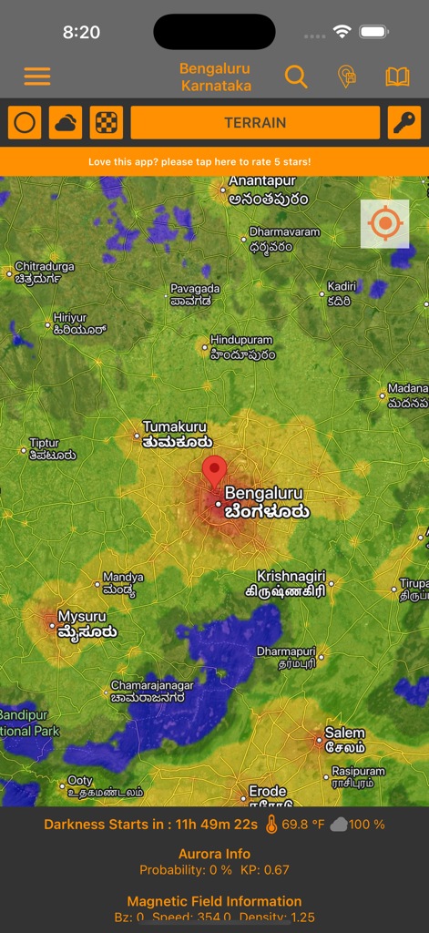
별 관측을 위한 지형 및 어둠 데이터가 표시된 대화형 광공해 지도
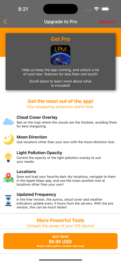
광공해 지도 프로 버전 업그레이드 화면 스크린샷, 프리미엄 기능 및 구독 가격 목록 표시
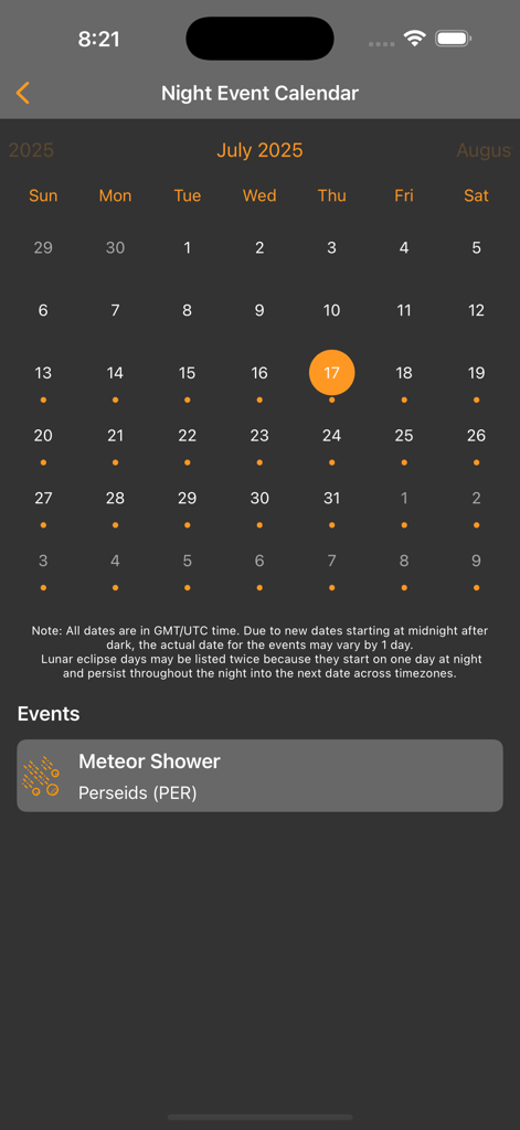
유성우 알림이 있는 밤 이벤트 캘린더를 보여주는 모바일 화면.
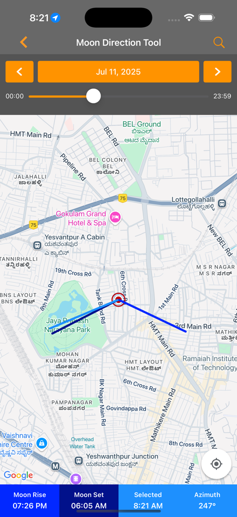
별 관측 계획을 위한 지도상의 위치를 보여주는 달 방향 도구 인터페이스
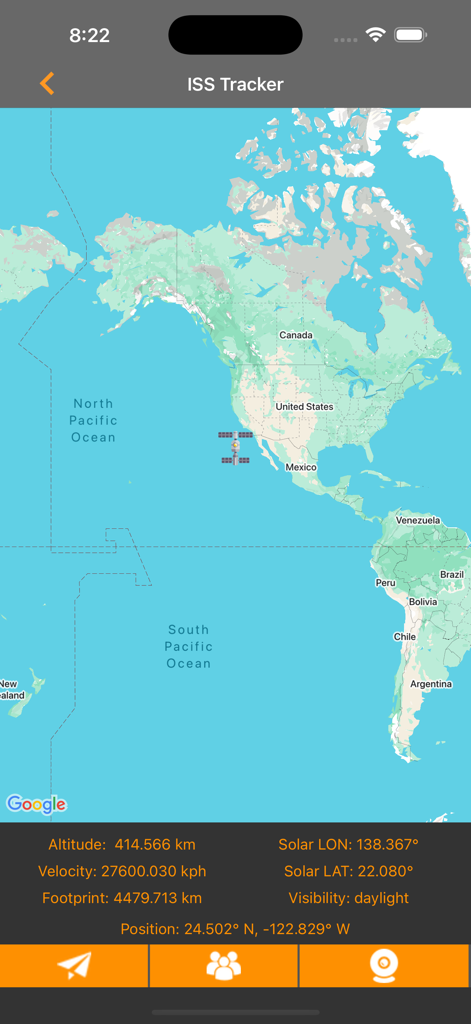
고도 및 속도 데이터가 있는 국제 우주 정거장 실시간 추적 지도
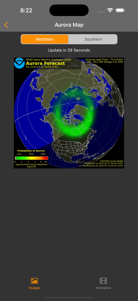
북반구 지도를 오버레이한 오로라 예측을 보여주는 광공해 앱의 오로라 지도 화면 스크린샷.
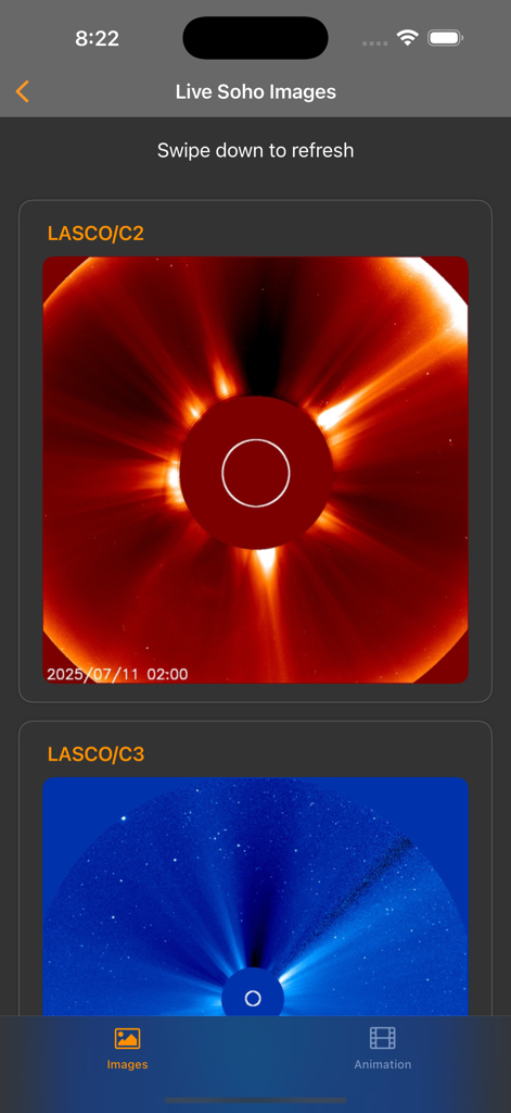
코로나그래프 태양을 보여주는 SOHO 임무의 실시간 태양 이미지
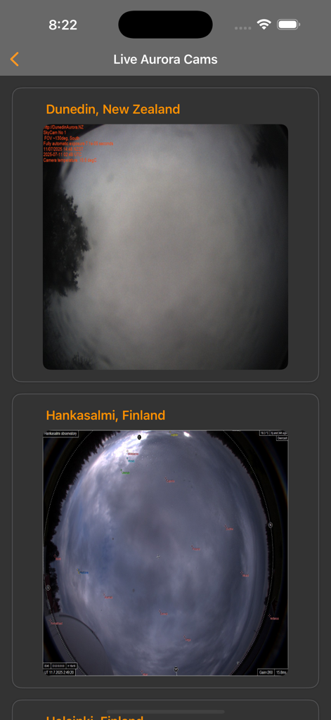
뉴질랜드와 핀란드의 실시간 오로라 카메라 피드를 보여주는 모바일 인터페이스
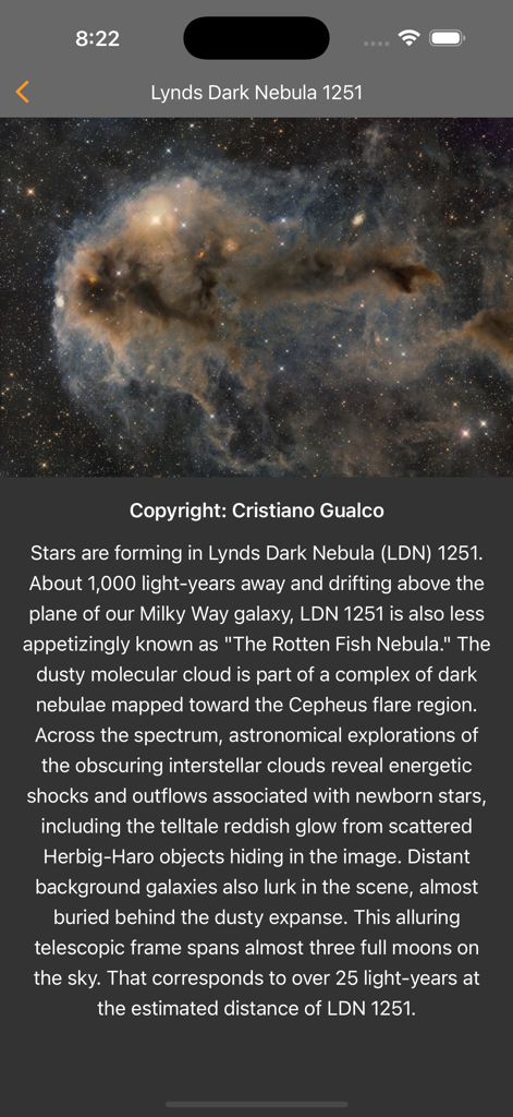
앱 내에서 Lynds Dark Nebula 1251을 보여주는 오늘의 천문 사진
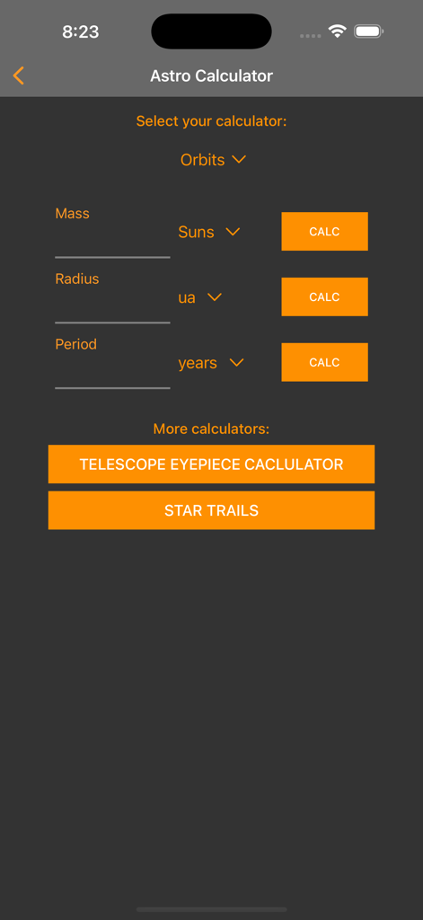
궤도 계산, 망원경 접안 렌즈 도구 및 별 궤적 설정을 보여주는 천체 계산기 화면
설명
Download
비슷한 앱
유사한 기능과 사용자 경험을 가진 앱

Moon Phases and Lunar Calendar
Business City s.r.o.

My Moon Phase - Lunar Calendar
JRustonApps B.V.

The Moon: Calendar Moon Phases
Vitalii Gryniuk

Moonlitt: Moon Phase Tracker
Flipping Hues Srls

Sunrise Sunset Times
Fascinating Projects Pty Ltd

PhotoPills
PhotoPills S.L.

AuroraReach
HuskyCodes Oy

Sun Seeker - Sunlight Tracker
Ajnaware Pty Ltd

Sun Tracker AR
Zuzana Eskinasi
이 페이지는 앱이나 개발자의 공식 페이지가 아니며, 정보 제공 및 논평을 목적으로 작성된 독립 편집 간행물입니다. 명시적으로 달리 언급되지 않는 한, 해당 앱이나 개발자는 MWM, Apple, Google Play, 앱 퍼블리셔 또는 앱 개발자와 제휴, 보증, 후원, 승인 또는 공식적으로 연결되어 있지 않으며, 이 페이지의 어떤 내용도 해당 앱이 MWM의 서비스를 사용하여 개발되었음을 의미하지 않습니다. 모든 상표, 로고, 스크린샷 및 기타 콘텐츠는 해당 소유자의 자산입니다.