이 페이지는 앱이나 개발자의 공식 페이지가 아니며, 정보 제공 및 논평을 목적으로 작성된 독립 편집 간행물입니다. 명시적으로 달리 언급되지 않는 한, 해당 앱이나 개발자는 MWM, Apple, Google Play, 앱 퍼블리셔 또는 앱 개발자와 제휴, 보증, 후원, 승인 또는 공식적으로 연결되어 있지 않으며, 이 페이지의 어떤 내용도 해당 앱이 MWM의 서비스를 사용하여 개발되었음을 의미하지 않습니다. 모든 상표, 로고, 스크린샷 및 기타 콘텐츠는 해당 소유자의 자산입니다.

Light Pollution Map
전문적인 VIIRS 데이터, 보틀 등급 추정치, 실시간 오로라 예보를 활용하여 오프라인에서도 천문학 및 천체 사진 촬영에 완벽한 장소를 찾으세요.
다운로드
161K+사용자 평점
총 평가 수
0개발사
카테고리
Navigation지원 언어
1최신 버전
1.1.29크기
19.9 MB출시일
2020년 9월 20일정밀 도구로 밤하늘 마스터하기
과학 등급의 복사광선 지도, 실시간 구름 추적, 전 세계 SQM 데이터를 사용하여 다음 천체 사진 촬영 또는 별 관측 여행을 계획하세요.
고급 광공해 오버레이
VIIRS, World Atlas 및 사용자가 제출한 SQM 측정값을 사용하여 과학적 정확도로 가장 어두운 보틀 등급 위치를 찾으세요.
실시간 하늘 조건
구름 덮개 애니메이션과 오로라 예보로 날씨보다 앞서 나가 완벽한 가시성을 보장하여 관측의 밤을 즐기세요.
다음 스크린샷과 설명은 앱의 공식 스토어 목록에서 직접 가져온 것이며 앱 개발자의 자산입니다.
앱 스토어
스크린샷
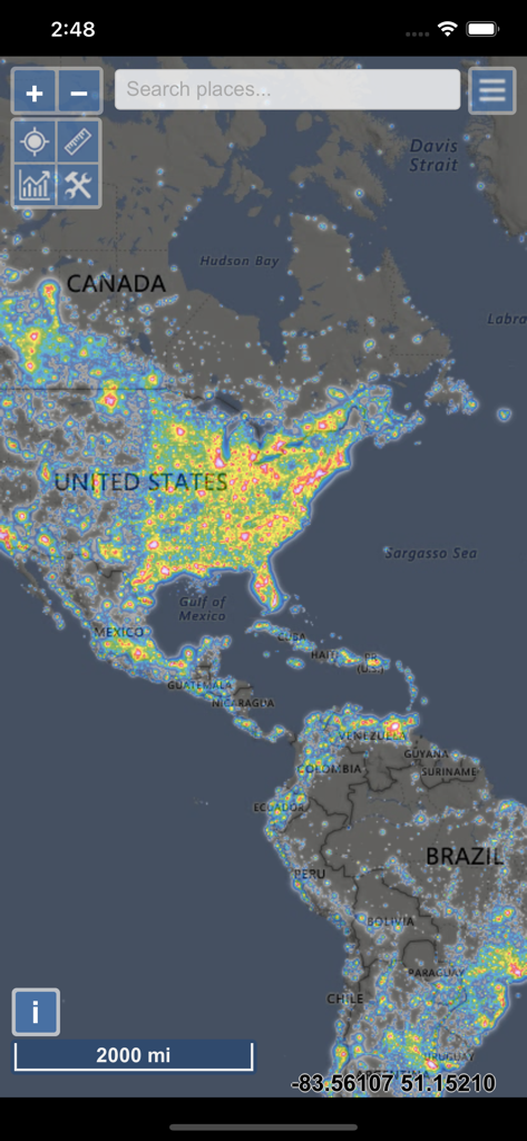
앱 인터페이스에서 북미 및 남미의 광공해 히트맵
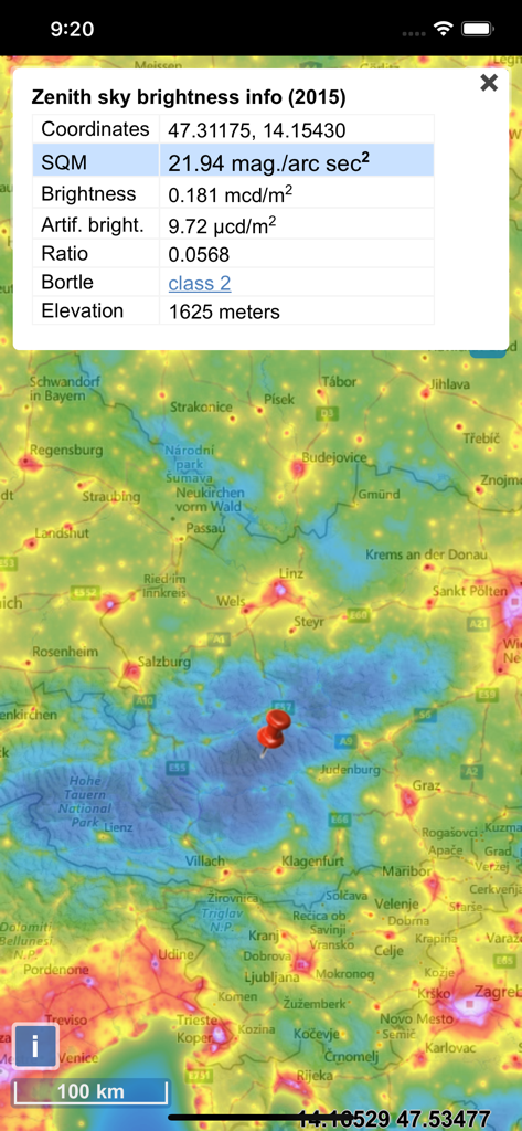
하늘 밝기 및 보틀 등급 데이터를 보여주는 광공해 지도 인터페이스
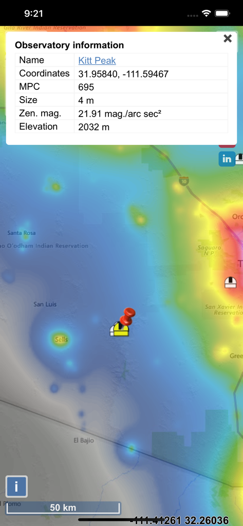
광공해 수준 및 Kitt Peak 천문대의 세부 정보를 보여주는 지도 표시.
광공해 지도 인터페이스에서 SQM 하늘 품질 판독값과 광도 히트맵 오버레이를 표시합니다
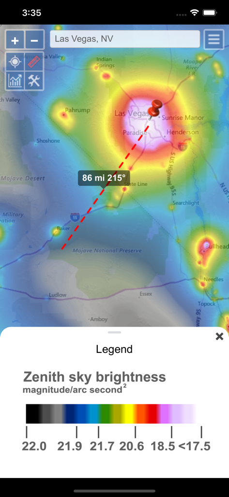
라스베이거스 지역의 광공해 지도로, Zenith 하늘 밝기 수준과 Mojave 국립 보호 구역을 가리키는 거리 측정 도구가 표시됩니다.
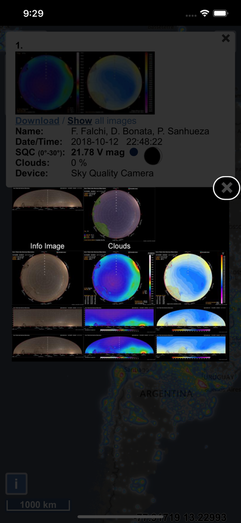
지도에 표시된 상세한 하늘 품질 카메라 지표 및 광공해 데이터 오버레이.
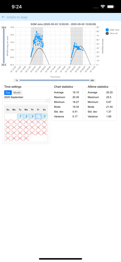
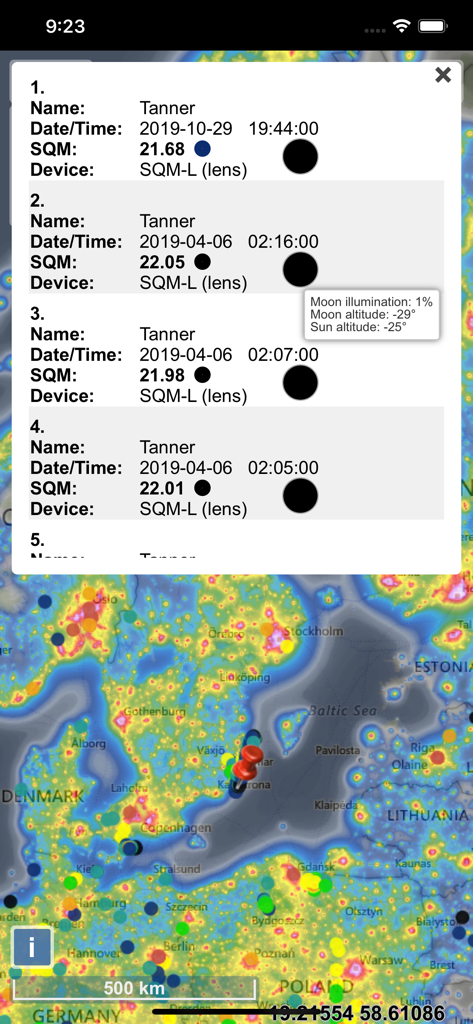
시간 경과에 따른 Sky Quality Meter 데이터 및 달 고도 통계 차트
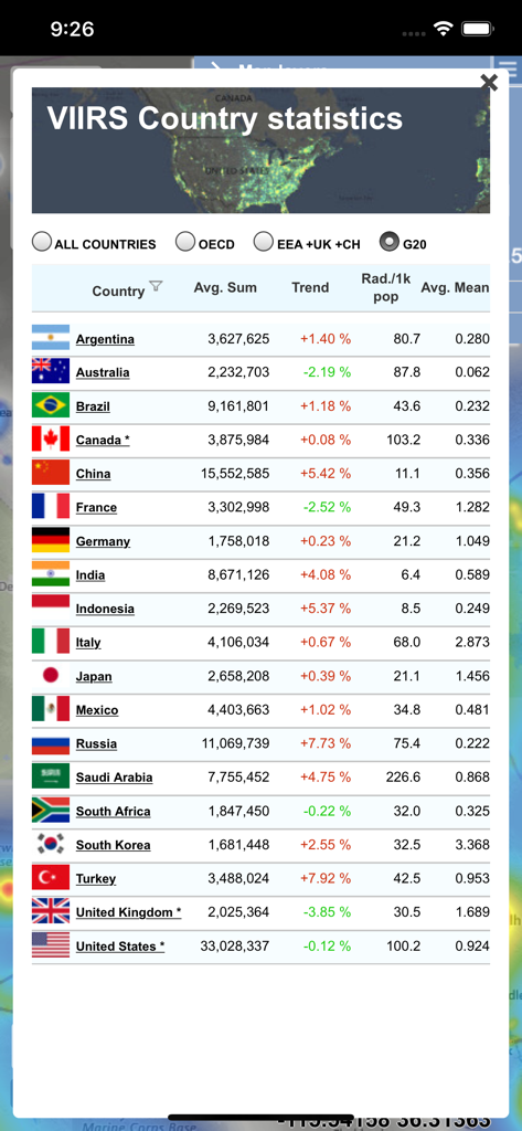
광공해 지도 앱 내 국가별 광공해 통계 및 복사광선 추세를 보여주는 데이터 테이블.
설명
Download
비슷한 앱
유사한 기능과 사용자 경험을 가진 앱

Moon Phases and Lunar Calendar
Business City s.r.o.

My Moon Phase - Lunar Calendar
JRustonApps B.V.

The Moon: Calendar Moon Phases
Vitalii Gryniuk

Moonlitt: Moon Phase Tracker
Flipping Hues Srls

Sunrise Sunset Times
Fascinating Projects Pty Ltd

PhotoPills
PhotoPills S.L.

AuroraReach
HuskyCodes Oy

Sun Seeker - Sunlight Tracker
Ajnaware Pty Ltd

Sun Tracker AR
Zuzana Eskinasi
이 페이지는 앱이나 개발자의 공식 페이지가 아니며, 정보 제공 및 논평을 목적으로 작성된 독립 편집 간행물입니다. 명시적으로 달리 언급되지 않는 한, 해당 앱이나 개발자는 MWM, Apple, Google Play, 앱 퍼블리셔 또는 앱 개발자와 제휴, 보증, 후원, 승인 또는 공식적으로 연결되어 있지 않으며, 이 페이지의 어떤 내용도 해당 앱이 MWM의 서비스를 사용하여 개발되었음을 의미하지 않습니다. 모든 상표, 로고, 스크린샷 및 기타 콘텐츠는 해당 소유자의 자산입니다.