이 페이지는 앱이나 개발자의 공식 페이지가 아니며, 정보 제공 및 논평을 목적으로 작성된 독립 편집 간행물입니다. 명시적으로 달리 언급되지 않는 한, 해당 앱이나 개발자는 MWM, Apple, Google Play, 앱 퍼블리셔 또는 앱 개발자와 제휴, 보증, 후원, 승인 또는 공식적으로 연결되어 있지 않으며, 이 페이지의 어떤 내용도 해당 앱이 MWM의 서비스를 사용하여 개발되었음을 의미하지 않습니다. 모든 상표, 로고, 스크린샷 및 기타 콘텐츠는 해당 소유자의 자산입니다.

다운로드
10K+사용자 평점
총 평가 수
200개발사
카테고리
Navigation지원 언어
1최신 버전
1.7.0크기
80.3 MB출시일
2024년 7월 20일정밀하게 세상을 탐색하고 측정하세요
DIY 사용자와 부동산 전문가 모두가 쉽게 모든 위치를 시각화하고 거리를 계산할 수 있도록 설계된 올인원 툴킷입니다.
전문적인 면적 측정
DIY 사용자와 부동산 전문가를 위해 설계된 고정밀 GPS 도구를 사용하여 토지 면적, 필지 크기 또는 경계선을 즉시 계산하세요.
실시간 위성 및 거리 탐색
고해상도 지구 보기를 통해 시각적인 확실성을 확보하세요. 이동 경로를 미리 확인하거나 손안에서 세계적으로 유명한 명소를 둘러보세요.
다음 스크린샷과 설명은 앱의 공식 스토어 목록에서 직접 가져온 것이며 앱 개발자의 자산입니다.
앱 스토어
스크린샷
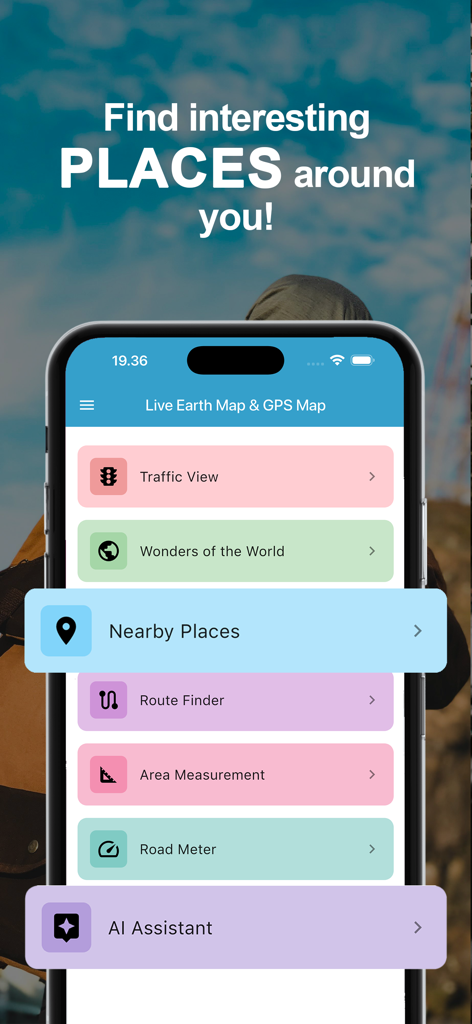
라이브 지구 지도 및 GPS 지도 앱의 메인 메뉴를 보여주는 화면으로, 내비게이션 및 면적 측정 기능이 표시됩니다.

여행 앱에서 영화관 추천을 제공하는 AI 어시스턴트를 보여주는 스마트폰 화면입니다.
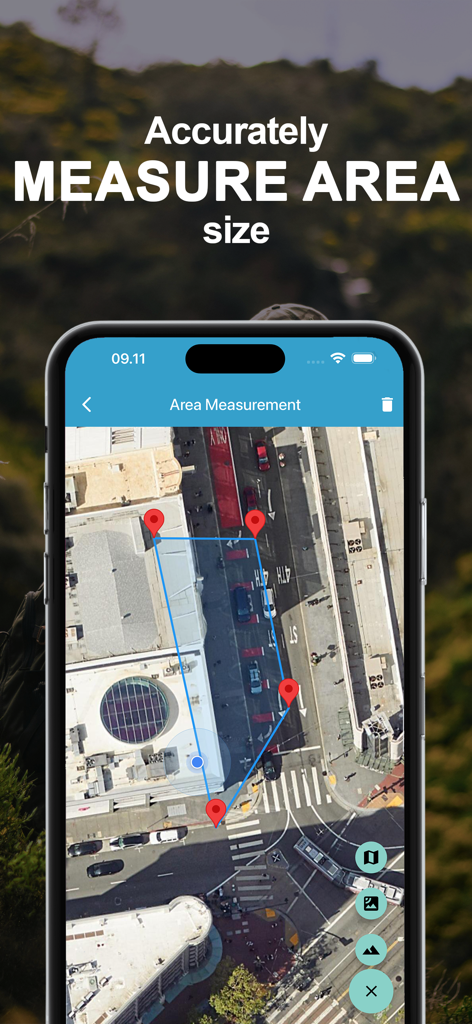
핀 마커로 토지 면적 측정을 보여주는 위성 지도 인터페이스입니다.
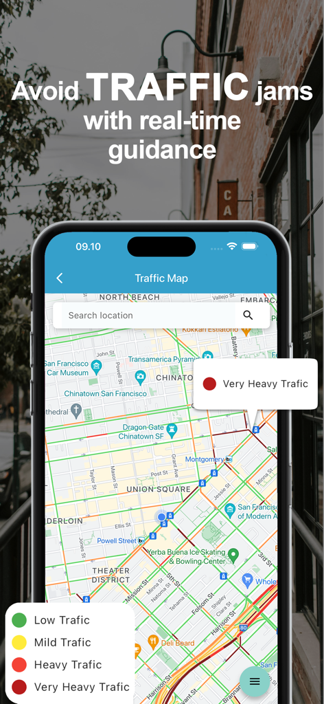
색상으로 구분된 교통 밀도와 검색창이 있는 실시간 교통 지도를 보여주는 모바일 앱 인터페이스입니다.
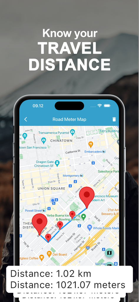
도시 지도에서 여러 핀으로 총 거리를 킬로미터로 계산하는 여행 거리 측정 도구를 보여주는 스마트폰입니다.
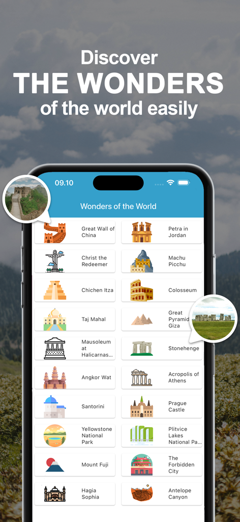
만리장성, 마추픽추와 같은 세계적으로 유명한 랜드마크와 관광지 목록을 표시하는 모바일 앱 인터페이스입니다.
설명
Download
비슷한 앱
같은 카테고리의 상위 앱

Google Maps
Google LLC

Waze Navigation & Live Traffic
waze

AMap Global
AutoNavi Information Technology Co. Ltd.

百度地图-路线规划,出行必备
Beijing Baidu Netcom Science & Technology Co.,Ltd

Moovit: Bus & Transit Tracker
Moovit App Global LTD

Transit • Subway & Bus Times
9280-0366 Quebec inc.

ParkMobile: Park. Pay. Go.
Parkmobile USA, Inc

腾讯地图-路线规划,导航地铁打车出行
Shenzhen Tencent Computer Systems Company Limited

Île-de-France Mobilités
Ile de France Mobilites
이 페이지는 앱이나 개발자의 공식 페이지가 아니며, 정보 제공 및 논평을 목적으로 작성된 독립 편집 간행물입니다. 명시적으로 달리 언급되지 않는 한, 해당 앱이나 개발자는 MWM, Apple, Google Play, 앱 퍼블리셔 또는 앱 개발자와 제휴, 보증, 후원, 승인 또는 공식적으로 연결되어 있지 않으며, 이 페이지의 어떤 내용도 해당 앱이 MWM의 서비스를 사용하여 개발되었음을 의미하지 않습니다. 모든 상표, 로고, 스크린샷 및 기타 콘텐츠는 해당 소유자의 자산입니다.