이 페이지는 앱이나 개발자의 공식 페이지가 아니며, 정보 제공 및 논평을 목적으로 작성된 독립 편집 간행물입니다. 명시적으로 달리 언급되지 않는 한, 해당 앱이나 개발자는 MWM, Apple, Google Play, 앱 퍼블리셔 또는 앱 개발자와 제휴, 보증, 후원, 승인 또는 공식적으로 연결되어 있지 않으며, 이 페이지의 어떤 내용도 해당 앱이 MWM의 서비스를 사용하여 개발되었음을 의미하지 않습니다. 모든 상표, 로고, 스크린샷 및 기타 콘텐츠는 해당 소유자의 자산입니다.

Live Earth Maps 3D GPS View
몰입감 넘치는 위성 보기와 실시간 거리 내비게이션으로 세상을 경험하세요. 다음 로드 트립을 계획하든 집에서 세계 랜드마크를 둘러보든, 저희의 올인원 탐색기가 지구를 여러분의 손안에 가져다줄 것입니다.
다운로드
2K+사용자 평점
총 평가 수
0개발사
카테고리
Navigation지원 언어
1최신 버전
2.0크기
60.4 MB출시일
2024년 8월 25일세상을 이전과는 다르게 보세요
모든 여정에 맞춰진 고화질 3D 보기와 실시간 위성 이미지를 통해 더욱 몰입감 있는 탐색 및 발견 방법을 경험하세요.
몰입감 넘치는 3D 거리 보기
도착 전에 주차 공간, 입구 및 주변 환경을 미리 파악하기 위해 목적지를 가상으로 '걸어' 다니며 여행 불안을 해소하세요.
나만의 가상 여행 가이드
호기심 많은 탐험가를 위한 흥미로운 국가 정보와 함께 세계 7대 불가사의와 세계 랜드마크를 놀라운 디테일로 탐험하세요.
자주 묻는 질문
에 대해 알아야 할 모든 것 Live Earth Maps 3D GPS View
라이브 어스 맵스 3D GPS 뷰 앱의 주요 목적은 무엇인가요?
라이브 어스 맵스 3D GPS 뷰 앱은 실시간 지도, 스트리트 뷰, 3D 위성 뷰를 결합하여 실시간 전 세계 탐색 기능을 제공하며, 내비게이션, 랜드마크 투어, 주변 장소 찾기에 유용합니다.
라이브 어스 맵스 3D GPS 뷰는 실시간 GPS 내비게이션을 제공하나요?
네, 라이브 어스 맵스 3D GPS 뷰 앱은 실시간 GPS 내비게이션 및 경로 계획 도구를 제공합니다. 실시간 추적 기능을 통해 사용자가 안심하고 여정을 안내받을 수 있습니다.
라이브 어스 맵스 3D GPS 뷰를 사용하여 주변 장소를 찾을 수 있나요?
네, 라이브 어스 맵스 3D GPS 뷰를 통해 사용자는 주변 명소를 탐색할 수 있습니다. 지도 스트리트 뷰를 사용하여 레스토랑, 주유소, ATM, 병원, 공원과 같은 장소를 찾는 데 도움이 됩니다.
라이브 어스 맵스 3D GPS 뷰는 내 현재 위치를 찾는 데 어떻게 도움이 되나요?
라이브 어스 맵스 3D GPS 뷰 앱은 라이브 지구 지도와 3D 위성 뷰를 사용하여 현재 위치를 정확하게 찾습니다. 대화형 지도에 사용자의 정확한 위치를 표시합니다.
라이브 어스 맵스 3D GPS 뷰는 몰입감 있는 스트리트 뷰 경험을 제공하나요?
네, 라이브 어스 맵스 3D GPS 뷰는 몰입감 있는 스트리트 뷰를 제공합니다. 사용자는 상세한 스트리트 뷰 지도 기능을 통해 전 세계 거리를 가상으로 걸으며 다양한 장소를 탐색할 수 있습니다.
라이브 어스 맵스 3D GPS 뷰 앱에서 즐겨찾는 장소를 저장할 수 있나요?
네, 라이브 어스 맵스 3D GPS 뷰는 사용자가 즐겨찾는 장소를 저장할 수 있도록 허용합니다. 사용자는 중요한 장소를 북마크하여 고해상도 3D 위성 뷰와 GPS 실시간 스트리트 뷰로 언제든지 다시 방문할 수 있습니다.
라이브 어스 맵스 3D GPS 뷰는 3D로 랜드마크를 탐색하는 것을 지원하나요?
네, 라이브 어스 맵스 3D GPS 뷰는 3D로 랜드마크를 탐색하는 것을 지원합니다. 사용자는 고급 3D 뷰 도구를 사용하여 에펠탑이나 빅벤과 같은 세계적인 상징적인 랜드마크를 둘러볼 수 있습니다.
라이브 어스 맵스 3D GPS 뷰를 사용하여 국가에 대한 사실을 배울 수 있나요?
네, 라이브 어스 맵스 3D GPS 뷰는 사용자가 국가에 대한 흥미로운 사실을 배울 수 있도록 합니다. 이 기능은 라이브 지도 위성 뷰에서 볼 때 교육과 탐색을 결합합니다.
다음 스크린샷과 설명은 앱의 공식 스토어 목록에서 직접 가져온 것이며 앱 개발자의 자산입니다.
앱 스토어
스크린샷
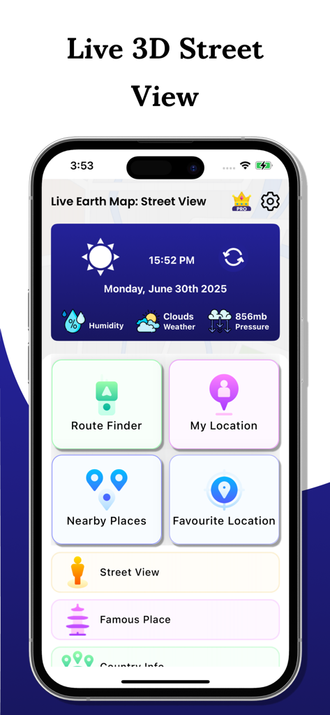
내비게이션 및 날씨 도구가 있는 라이브 지구 지도 3D GPS 보기 앱의 홈 화면 대시보드
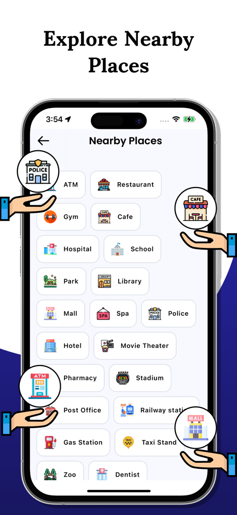
레스토랑 및 주유소와 같은 다양한 주변 장소 카테고리를 보여주는 라이브 지구 지도 앱 화면
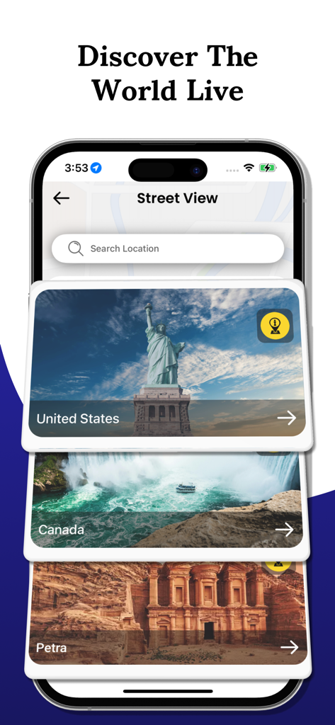
미국, 캐나다, 페트라에 대한 거리 보기 옵션과 '세계를 라이브로 발견하세요'라는 텍스트가 있는 모바일 앱 인터페이스
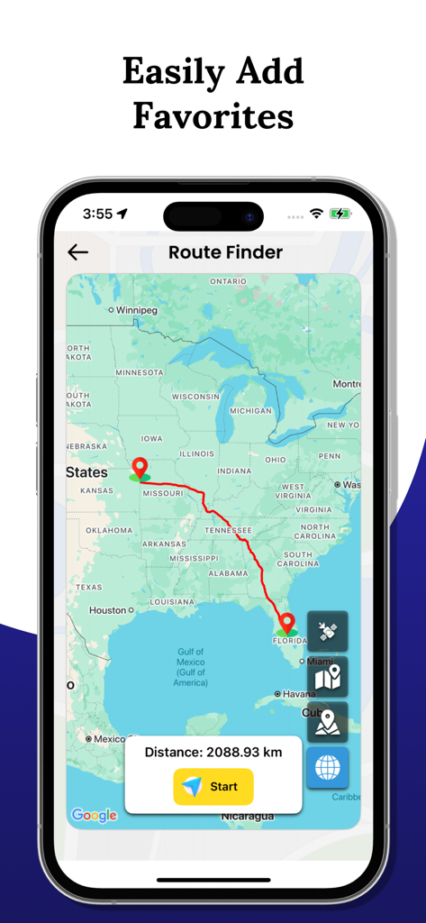
미국 지도에서 중서부에서 플로리다까지의 경로를 보여주는 경로 찾기 기능이 있는 라이브 지구 지도 3D GPS 보기 앱의 인터페이스
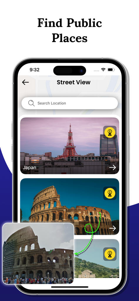
도쿄 타워와 콜로세움 이미지가 있는 거리 보기 기능의 스마트폰 화면
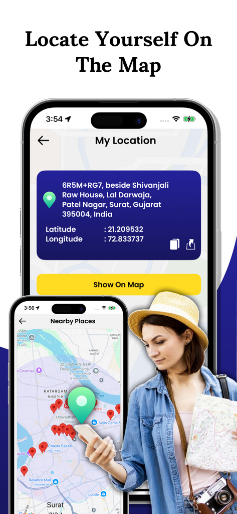
3D 지도에서 사용자 위치를 찾고 주변 장소를 찾는 모바일 앱 인터페이스
설명
Download
비슷한 앱
같은 카테고리의 상위 앱

Google Maps
Google LLC

AMap Global
AutoNavi Information Technology Co. Ltd.

Waze Navigation & Live Traffic
waze

百度地图-路线规划,出行必备
Beijing Baidu Netcom Science & Technology Co.,Ltd

Moovit: Bus & Transit Tracker
Moovit App Global LTD

Transit • Subway & Bus Times
9280-0366 Quebec inc.

ParkMobile: Park. Pay. Go.
Parkmobile USA, Inc

腾讯地图-路线规划,导航地铁打车出行
Shenzhen Tencent Computer Systems Company Limited

MapXplorer: Map Radar Navigate
GOLDLAB APPLICATIONS YAZILIM VE BILISIM ANONIM SIRKETI
이 페이지는 앱이나 개발자의 공식 페이지가 아니며, 정보 제공 및 논평을 목적으로 작성된 독립 편집 간행물입니다. 명시적으로 달리 언급되지 않는 한, 해당 앱이나 개발자는 MWM, Apple, Google Play, 앱 퍼블리셔 또는 앱 개발자와 제휴, 보증, 후원, 승인 또는 공식적으로 연결되어 있지 않으며, 이 페이지의 어떤 내용도 해당 앱이 MWM의 서비스를 사용하여 개발되었음을 의미하지 않습니다. 모든 상표, 로고, 스크린샷 및 기타 콘텐츠는 해당 소유자의 자산입니다.