이 페이지는 앱이나 개발자의 공식 페이지가 아니며, 정보 제공 및 논평을 목적으로 작성된 독립 편집 간행물입니다. 명시적으로 달리 언급되지 않는 한, 해당 앱이나 개발자는 MWM, Apple, Google Play, 앱 퍼블리셔 또는 앱 개발자와 제휴, 보증, 후원, 승인 또는 공식적으로 연결되어 있지 않으며, 이 페이지의 어떤 내용도 해당 앱이 MWM의 서비스를 사용하여 개발되었음을 의미하지 않습니다. 모든 상표, 로고, 스크린샷 및 기타 콘텐츠는 해당 소유자의 자산입니다.
MapCam - GPS Map Camera
GPS 좌표, 타임스탬프 및 전문 메타데이터를 사진에 즉시 오버레이하세요. 100% 개인 정보를 염두에 두고 제작된 현장 전문가 및 아웃도어 탐험가를 위한 올인원 문서 도구입니다.
주요 수치
다운로드
2K+
사용자 평점
4.8/5
총 평가 수
0
개발사
HKINFOWAY TECHNOLOGIES
카테고리
Navigation
지원 언어
12
최신 버전
1.5
크기
37.4 MB
출시일
2025년 6월 15일
기능
모든 프레임에 담긴 전문적인 정밀도
현장 작업자와 모험가를 위한 최고의 지오태깅 도구입니다. 자동 GPS, 타임스탬프 및 환경 데이터를 사용하여 사진을 캡처하여 절대적인 정확도로 작업과 세상을 문서화하세요.
즉각적인 지오태깅 및 증명
위도, 경도 및 타임스탬프를 사진에 자동으로 스탬프하여 검사, 부동산 또는 여행 기록에 대한 강력한 지역 증거를 제공합니다.
풍부한 메타데이터 오버레이
고해상도 이미지에 고도, 날씨 조건, 습도 및 나침반 방향을 직접 포함하여 위치를 넘어선 풍부한 정보를 제공하여 전체 컨텍스트를 제공합니다.
다음 스크린샷과 설명은 앱의 공식 스토어 목록에서 직접 가져온 것이며 앱 개발자의 자산입니다.
앱 스토어
스크린샷
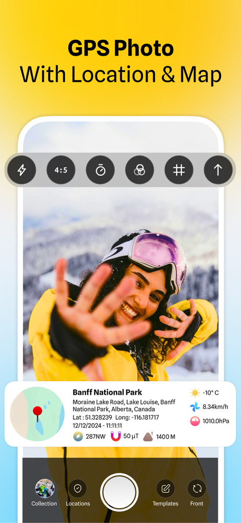
GPS 좌표 지도 및 날씨 데이터가 있는 사진이 표시되는 MapCam 인터페이스
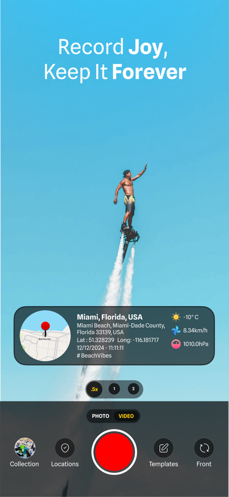
GPS 위치 및 날씨 스탬프가 있는 플라이보더를 보여주는 MapCam 앱 인터페이스
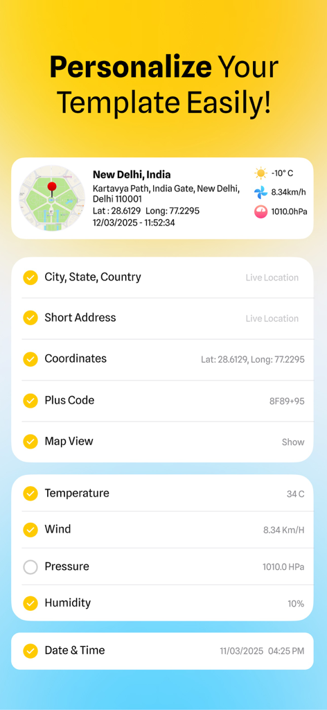
GPS 좌표, 주소 및 날씨 데이터로 사진 스탬프를 사용자 지정하는 옵션을 보여주는 MapCam 앱의 인터페이스
GPS 위치 및 날짜 스탬프 오버레이로 요가하는 여성
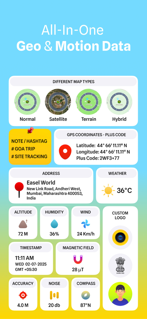
사진 및 비디오를 위한 GPS 좌표 날씨 고도 및 지도 유형을 보여주는 인터페이스.
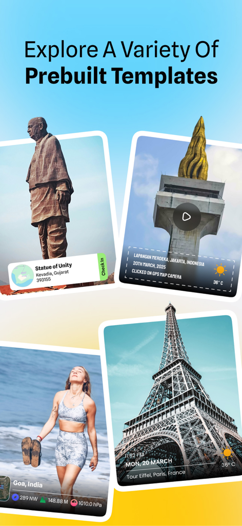
GPS 위치 및 타임스탬프로 사진 지오태깅을 위한 다양한 사전 제작 템플릿 쇼케이스
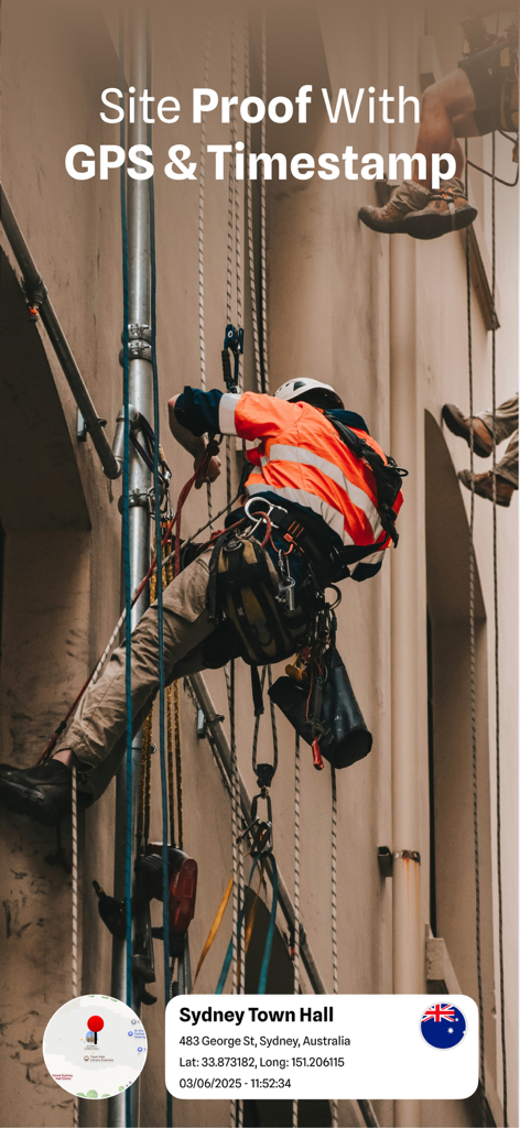
GPS 좌표 및 타임스탬프 오버레이로 현장 진행 상황을 문서화하는 건설 작업자
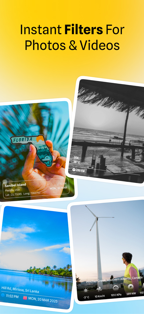
MapCam 앱의 GPS 위치 스탬프 및 시각적 필터가 있는 사진 예시
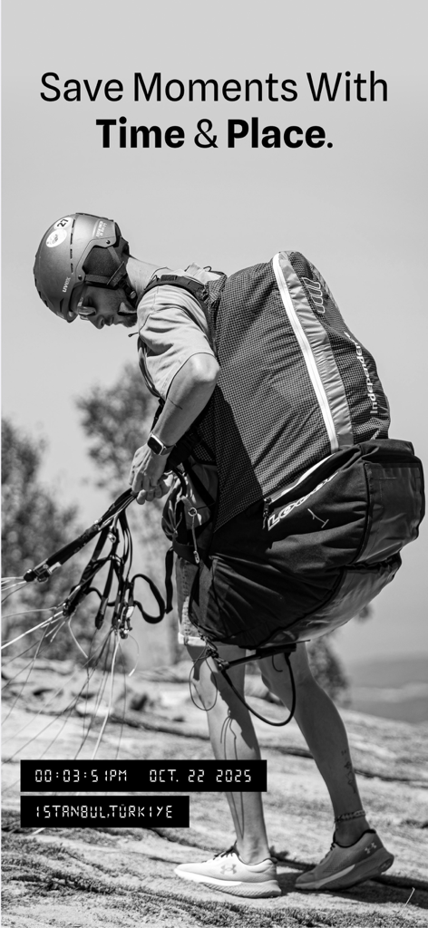
GPS 및 타임스탬프 태그가 있는 패러글라이더 사진을 보여주는 MapCam 앱
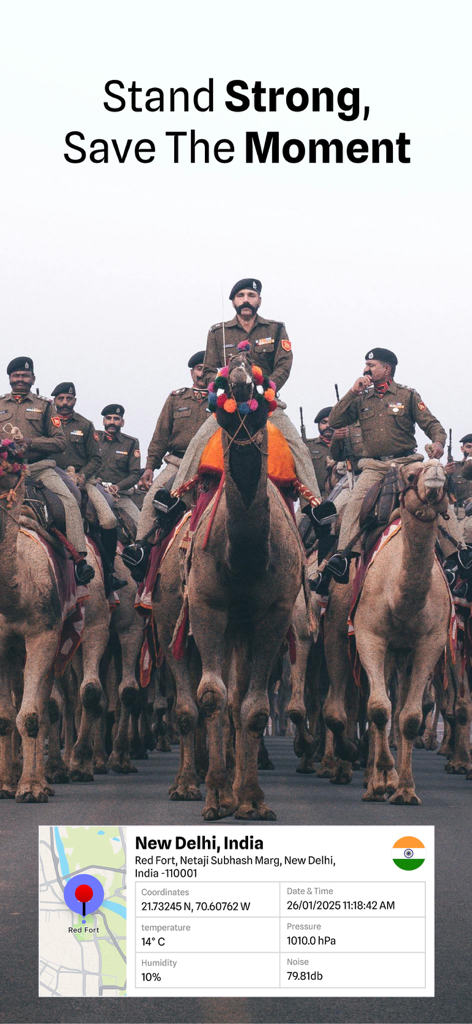
GPS 위치 및 환경 데이터가 포함된 뉴델리 낙타 퍼레이드의 지오태그 사진
설명
Capture, Tag, and Organize Your Photos with GPS & Timestamps! MapCam - GPS Map Camera is a powerful geotagging photo editor app designed for travelers, professionals, and field workers who need accurate location markers on their images and videos. Whether you're documenting a project, capturing travel memories, or providing proof of area for business, this app allows you to add geolocation coordinates, timestamps, and map details to your pictures with ease. With just one tap, capture shots with latitude, longitude, date, time, and compass direction—plus extra details like altitude, weather, temperature, humidity, and wind speed—to ensure every portrait is accurately marked. Ideal for surveying, real estate, journalism, street documentation, outdoor adventures, and more! Why Use a MapCam? Add GPS Coordinates to Photos: Geotag images and videos with accurate latitude and longitude using your live location or by manually selecting a spot on the built-in map. Add Timestamps and Custom Text: Overlay date, time, and place names on images, or add personalized notes with multiple layout and font options. Map Location Picker: Use an interactive map to pin any area or search by address to assign coordinates to a video or image. GPS Camera with Live Tags: Capture portraits directly within our app with real-time live location marks, dates, and custom tags applied automatically. High-Resolution Output: Maintain original image quality while adding geo mapper tags and timestamps. This app supports high-resolution exports. No Data Collection—100% Privacy: Our app does not collect, upload, or share your data—your photographs stay secure on your device. Advanced Features: - Customizable Stamps—Choose from multiple layouts, fonts, and colors. - Front & Back Camera Support—Capture photographs or videos using either camera with real-time location stamping. - Overlay Metadata Without Changing the Image—Keep your original photo intact while adding place markers and time stamp overlays. - Built-in Gallery & File Browser—Access, edit, and share geotagged photos quickly. How does it work? - Open MapCam and grant location access. - Capture a photo—geolocation coordinates, date, and time will be added automatically. - Customize your stamp layout, font, and marker format. - Save or share your geotagged marked videos & images with just one tap! Who Can Benefit from MapCam? - Tourists & Travelers—Keep a record of trips with location-stamped photos. - Surveyors & Engineers—Document projects with geotagged images. - Real Estate Agents—Capture property listings with verified site details. - Outdoor Enthusiasts—Track hikes, nature photography, and expeditions. - Investigators & Journalists—Save timestamped area-based evidence. - Businesses & Service Providers—Improve locale-based project documentation. - Field Workers & Engineers—Capture on-site progress, inspections, and project conditions with timestamped, geotagged images. - Social Media Creators—Create content enriched with place stamps and custom text, ready for posting. MapCam makes photo documentation simple, accurate, and professional. Whether on an adventure, working in the field, or capturing business records, this app ensures your images are always tagged with the correct GPS location details. Download today and start capturing GPS-stamped photos and videos with precision! Privacy Policy: https://gpsmapcamera.wallzy.app/privacy-policy Terms of use: https://gpsmapcamera.wallzy.app/terms-condition
이 페이지는 앱이나 개발자의 공식 페이지가 아니며, 정보 제공 및 논평을 목적으로 작성된 독립 편집 간행물입니다. 명시적으로 달리 언급되지 않는 한, 해당 앱이나 개발자는 MWM, Apple, Google Play, 앱 퍼블리셔 또는 앱 개발자와 제휴, 보증, 후원, 승인 또는 공식적으로 연결되어 있지 않으며, 이 페이지의 어떤 내용도 해당 앱이 MWM의 서비스를 사용하여 개발되었음을 의미하지 않습니다. 모든 상표, 로고, 스크린샷 및 기타 콘텐츠는 해당 소유자의 자산입니다.