이 페이지는 앱이나 개발자의 공식 페이지가 아니며, 정보 제공 및 논평을 목적으로 작성된 독립 편집 간행물입니다. 명시적으로 달리 언급되지 않는 한, 해당 앱이나 개발자는 MWM, Apple, Google Play, 앱 퍼블리셔 또는 앱 개발자와 제휴, 보증, 후원, 승인 또는 공식적으로 연결되어 있지 않으며, 이 페이지의 어떤 내용도 해당 앱이 MWM의 서비스를 사용하여 개발되었음을 의미하지 않습니다. 모든 상표, 로고, 스크린샷 및 기타 콘텐츠는 해당 소유자의 자산입니다.

Maptrails
오프라인 지형도, 고급 GIS 레이어, iPhone, iPad, Mac, Apple Watch 간의 원활한 동기화로 야외 활동을 마스터하세요. 구독 피로 없이 하이킹, 사냥, 탐험에 필요한 모든 기능.
다운로드
30K+사용자 평점
총 평가 수
300개발사
카테고리
Navigation지원 언어
11최신 버전
2025.7.2크기
28.0 MB출시일
2020년 8월 2일진지한 탐험가를 위한 고급 내비게이션
Maptrails는 구독 없이 기술적인 하이커, 사냥꾼, 내비게이터를 위해 전문가 수준의 매핑과 원활한 Apple 생태계 통합을 제공합니다.
원활한 Apple 생태계 동기화
Mac 또는 iPad에서 Apple Pencil 지원으로 트레킹을 계획하고, iCloud 동기화를 통해 iPhone 및 Apple Watch로 자신 있게 탐색하세요.
전문 데이터 및 오프라인 지도
정밀한 계획을 위해 GPX, KML, Shapefile을 가져오세요. 가장 깊은 오지에서도 100% 오프라인에서 사용할 수 있도록 지도 타일을 다운로드하세요.
다음 스크린샷과 설명은 앱의 공식 스토어 목록에서 직접 가져온 것이며 앱 개발자의 자산입니다.
앱 스토어
스크린샷
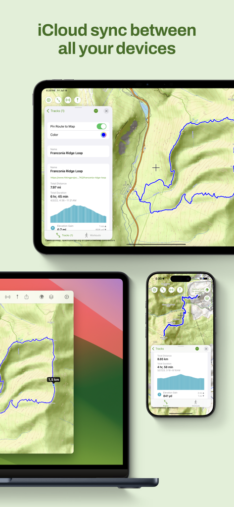
iPad, Mac, iPhone에서 Maptrails 앱 인터페이스가 하이킹 지도 및 트랙의 iCloud 동기화를 보여줍니다.
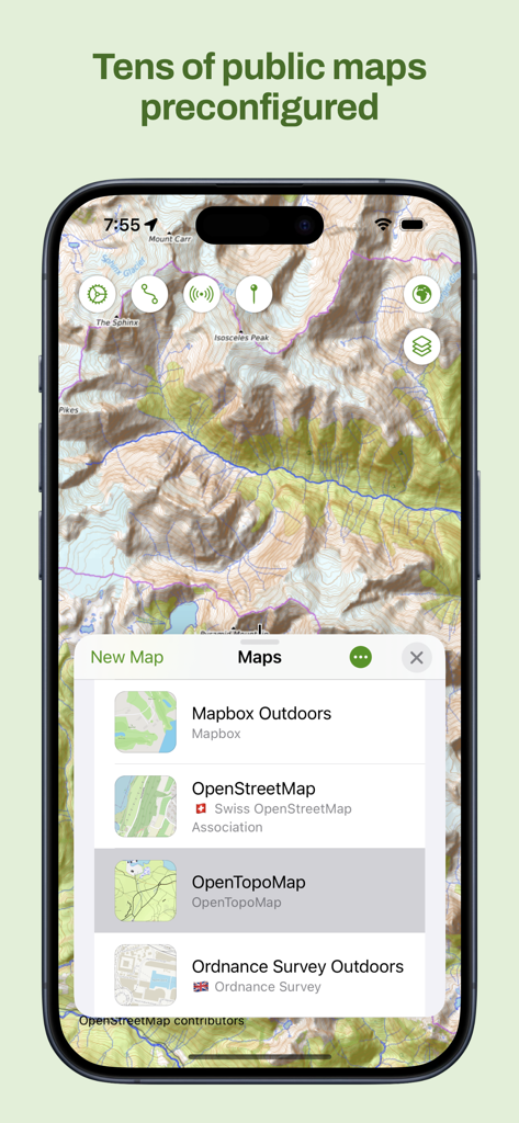
Maptrails 앱의 iPhone 스크린샷으로 OpenTopoMap과 같은 사전 구성된 공개 지도 목록과 지형도를 보여줍니다.
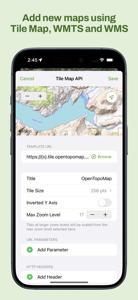
Maptrails 앱 인터페이스에서 사용자 지정 타일 맵 WMTS 및 WMS 레이어 추가
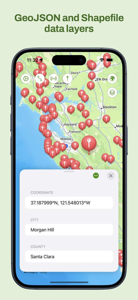
Maptrails 앱 인터페이스에서 위치 핀 및 좌표가 있는 GeoJSON 및 Shapefile 지도 레이어를 보여줍니다.
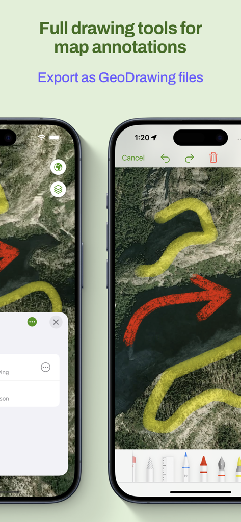
다양한 색상의 그리기 도구와 내보내기 옵션으로 지도 주석을 보여주는 스마트폰 화면.
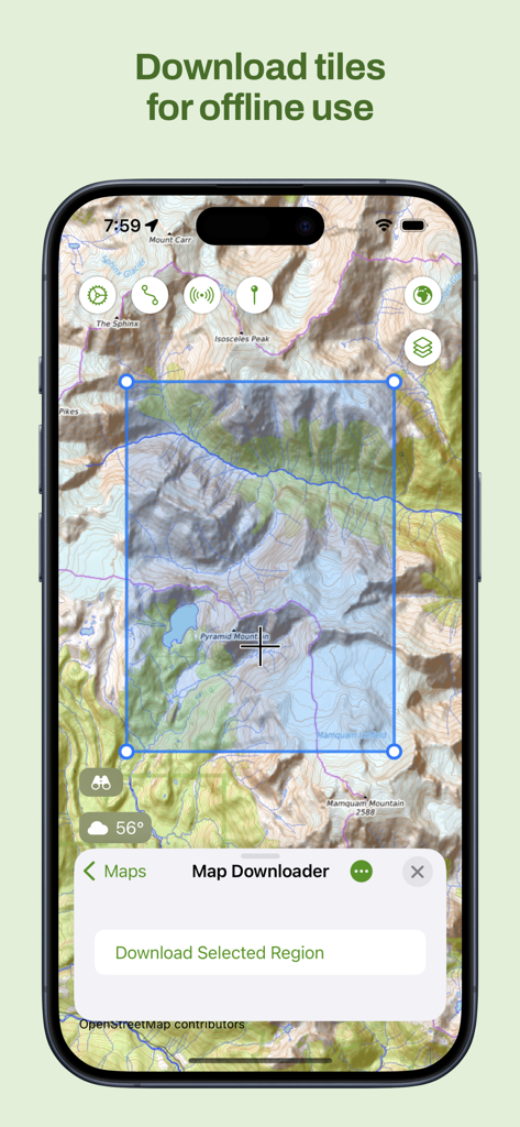
오프라인 사용을 위한 지형 지도 타일 선택 및 다운로드 인터페이스를 보여주는 Maptrails 앱의 iPhone 스크린샷
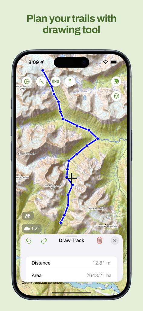
트랙 계획 도구를 사용하여 사용자 지정 하이킹 경로를 그린 Maptrails 앱 지형도 화면.
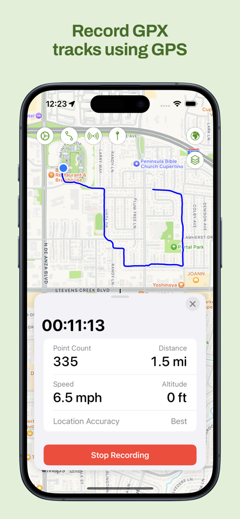
실시간 거리 및 속도 데이터와 함께 지도에서 GPX 트랙을 녹화하는 Maptrails iPhone 앱
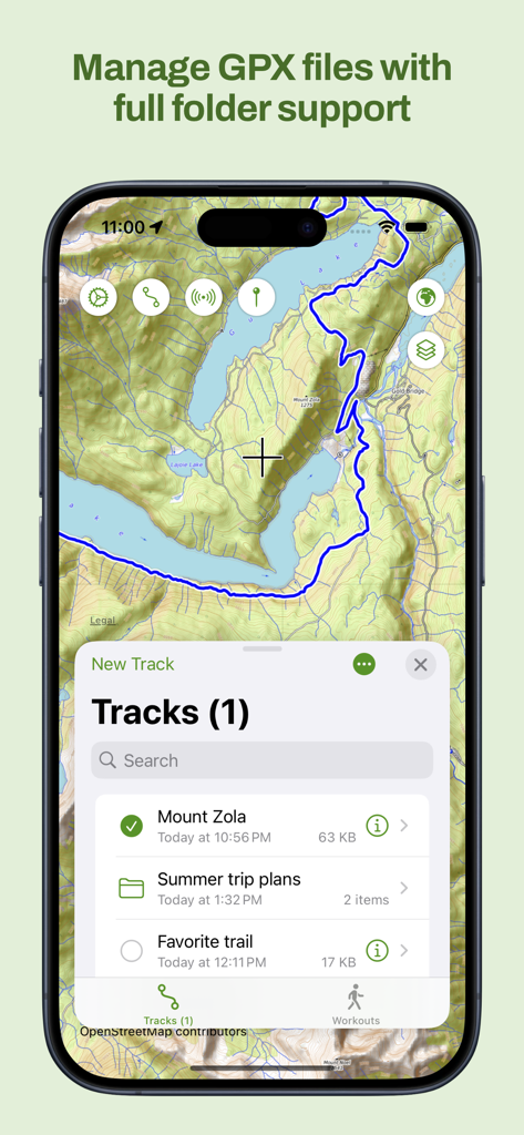
지형도에서 폴더 지원을 포함한 GPX 트랙 관리 인터페이스를 보여주는 Maptrails 앱
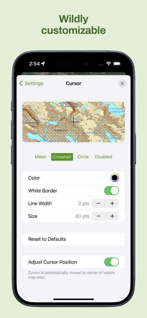
지형도에서 색상 및 크기와 같은 자세한 커서 사용자 지정 옵션을 보여주는 Maptrails 앱 인터페이스
설명
Download
비슷한 앱
유사한 기능과 사용자 경험을 가진 앱

PredictWind — Marine Forecasts
PredictWind Limited

Navily
The Navigation Family

Argo - Boating Navigation
Argo Navigation, LLC

SEAiq Pilot
Sakhalin, LLC

KartenWerft NavGo 2.0
KartenWerft GmbH

MarineTraffic - Ship Tracking
MARINETRAFFIC APPLICATIONS LTD

Wavve Boating: Marine Boat GPS
Wavve Boating Inc

Savvy Navvy Boating Navigation
SAVVY NAVVY LTD

Aqua Map Boating
GEC s.r.l.
이 페이지는 앱이나 개발자의 공식 페이지가 아니며, 정보 제공 및 논평을 목적으로 작성된 독립 편집 간행물입니다. 명시적으로 달리 언급되지 않는 한, 해당 앱이나 개발자는 MWM, Apple, Google Play, 앱 퍼블리셔 또는 앱 개발자와 제휴, 보증, 후원, 승인 또는 공식적으로 연결되어 있지 않으며, 이 페이지의 어떤 내용도 해당 앱이 MWM의 서비스를 사용하여 개발되었음을 의미하지 않습니다. 모든 상표, 로고, 스크린샷 및 기타 콘텐츠는 해당 소유자의 자산입니다.