이 페이지는 앱이나 개발자의 공식 페이지가 아니며, 정보 제공 및 논평을 목적으로 작성된 독립 편집 간행물입니다. 명시적으로 달리 언급되지 않는 한, 해당 앱이나 개발자는 MWM, Apple, Google Play, 앱 퍼블리셔 또는 앱 개발자와 제휴, 보증, 후원, 승인 또는 공식적으로 연결되어 있지 않으며, 이 페이지의 어떤 내용도 해당 앱이 MWM의 서비스를 사용하여 개발되었음을 의미하지 않습니다. 모든 상표, 로고, 스크린샷 및 기타 콘텐츠는 해당 소유자의 자산입니다.

Wavve Boating: Marine Boat GPS
복잡한 차트 플로터 사용에 어려움을 겪지 마세요. 보트 흘수 깊이에 맞춘 맞춤형 해도, 실시간 날씨, 친구 실시간 추적 기능을 하나의 사용하기 쉬운 앱에서 이용하세요.
다운로드
866K+사용자 평점
총 평가 수
5K+개발사
카테고리
Navigation지원 언어
1최신 버전
5.5.9크기
181.6 MB출시일
2017년 8월 12일모든 선장을 위한 간편한 보트 항해
복잡한 차트는 잊으세요. Wavve는 직관적인 항해, 실시간 안전 데이터, 소셜 연결 기능을 결합하여 물 위에서의 모든 날을 스트레스 없이 즐길 수 있도록 합니다.
맞춤형 안전 지도
보트의 흘수 깊이를 설정하면 Wavve가 어디로 안전하게 갈 수 있는지 보여줍니다. 빨간색 위험 구역을 피하고 파란색으로 표시된 안전한 경로만 따라가면 값비싼 프로펠러 손상을 방지할 수 있습니다.
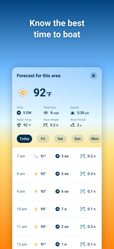
실시간 해양 날씨
7일 예보 및 조수 예측으로 날씨에 맞춰 계획을 세우세요. 부두를 떠나기도 전에 파도 높이와 바람 속도를 미리 파악할 수 있습니다.
자주 묻는 질문
에 대해 알아야 할 모든 것 Wavve Boating: Marine Boat GPS
Wavve Boating: Marine Boat GPS는 무엇인가요?
Wavve Boating: Marine Boat GPS는 보트 이용자를 위한 내비게이션 앱입니다. 해양 항해를 위한 상세한 해도, 조수 예측, 일기 예보를 하나의 사용하기 쉬운 도구로 제공합니다.
Wavve Boating: Marine Boat GPS 구독료는 얼마인가요?
Wavve Boating: Marine Boat GPS 구독료는 월별 옵션의 경우 월 $11.99, 연간 옵션의 경우 연 $59.99입니다. 14일 무료 체험 기간을 이용할 수 있습니다.
Wavve Boating: Marine Boat GPS에 무료 체험 기간이 있나요?
네, Wavve Boating: Marine Boat GPS는 14일 무료 체험 기간을 제공합니다. 사용자는 구독하기 전에 앱을 무료로 다운로드하여 기능을 사용할 수 있습니다.
Wavve Boating: Marine Boat GPS의 해도 데이터는 어떤 지역을 포함하나요?
Wavve Boating: Marine Boat GPS는 미국, 캐나다, 호주, 영국의 해도 데이터를 제공합니다. 사용자는 Wavve Boating 웹사이트에서 전체 커버리지 지도를 확인할 수 있습니다.
Wavve Boating: Marine Boat GPS는 해도 사용자 정의가 가능한가요?
네, Wavve Boating: Marine Boat GPS는 해도 사용자 정의가 가능합니다. 사용자는 자신의 보트의 흘수선(draft)을 설정할 수 있으며, 앱은 특정 보트에 맞게 해도 데이터를 다시 그립니다.
Wavve Boating: Marine Boat GPS는 조수 예측을 제공하나요?
네, Wavve Boating: Marine Boat GPS는 조수 예측을 제공합니다. 수위 변화를 추적하고 북미 지역의 경우 최대 18시간 앞의 예측 수위를 보여줍니다.
Wavve Boating: Marine Boat GPS에 일기 예보가 포함되어 있나요?
네, Wavve Boating: Marine Boat GPS는 포괄적인 일기 예보를 포함합니다. 북미 지역을 위한 7일 예보를 제공하며, 기온, 풍속, 파고를 표시합니다.
Wavve Boating: Marine Boat GPS에서 친구들과 위치를 공유할 수 있나요?
네, 사용자는 "Fleets of Friends" 기능을 사용하여 Wavve Boating: Marine Boat GPS에서 친구들과 위치를 공유할 수 있습니다. 사용자는 자신의 위치를 숨기도록 선택할 수도 있습니다.
Wavve Boating: Marine Boat GPS는 보트 이용자들이 위험을 피하는 데 도움이 되나요?
네, Wavve Boating: Marine Boat GPS는 보트 이용자들이 위험을 피하는 데 도움이 됩니다. 수면 위의 잠재적 위험을 강조하기 위해 색상으로 구분된 구역을 포함한 명확한 시각 정보를 제공합니다.
Wavve Boating: Marine Boat GPS를 오프라인으로 사용할 수 있나요?
네, Wavve Boating: Marine Boat GPS는 오프라인으로 사용할 수 있습니다. 사용자는 활성 인터넷 연결 없이도 항해를 계속하기 위해 해도 데이터를 다운로드할 수 있습니다.
Wavve Boating: Marine Boat GPS에서 관심 지점을 표시하고 공유할 수 있나요?
네, 사용자는 Wavve Boating: Marine Boat GPS에서 관심 지점을 표시할 수 있습니다. 지도에 공유 또는 개인 핀을 추가할 수 있으며, 공유된 지점에 대해서는 커뮤니티 투표가 가능합니다.
Wavve Boating: Marine Boat GPS는 어떤 다른 해양 GPS 앱을 대체할 수 있나요?
Wavve Boating: Marine Boat GPS는 Navionics, Embark, Garmin Active Captain과 같은 전통적인 차트 플로터 및 애플리케이션을 대체할 수 있으며, 해양 해도 데이터를 통합합니다.
Wavve Boating: Marine Boat GPS에는 자동 경로 설정 기능이 있나요?
네, Wavve Boating: Marine Boat GPS에는 자동 경로 설정 기능이 있습니다. 이 기능은 효율적인 해양 항해를 위해 설계된 포괄적인 도구 모음의 일부입니다.
다음 스크린샷과 설명은 앱의 공식 스토어 목록에서 직접 가져온 것이며 앱 개발자의 자산입니다.
앱 스토어
스크린샷
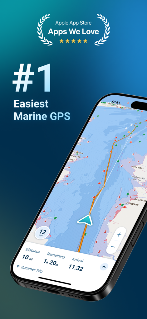
해도와 항해 정보가 표시된 Wavve Boating 해양 GPS 네비게이션 인터페이스를 보여주는 스마트폰
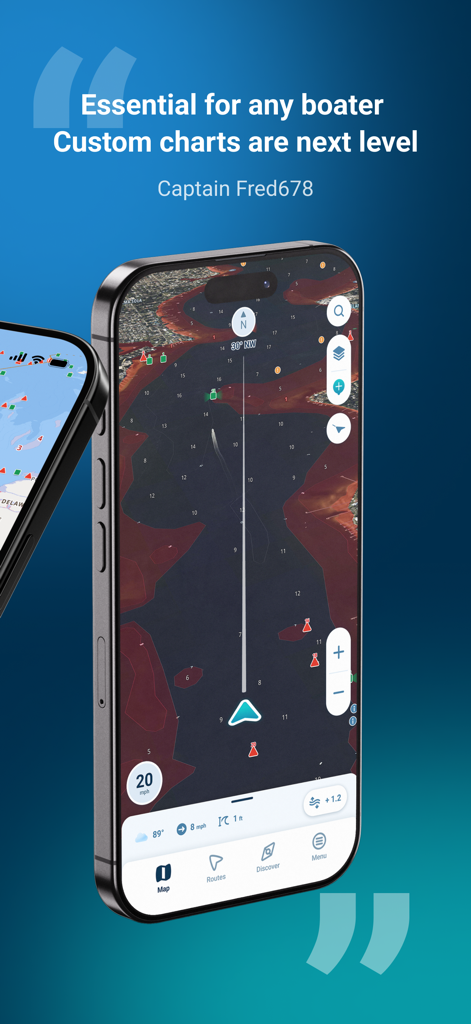
Wavve Boating 해도와 긍정적인 사용자 리뷰를 보여주는 스마트폰 화면
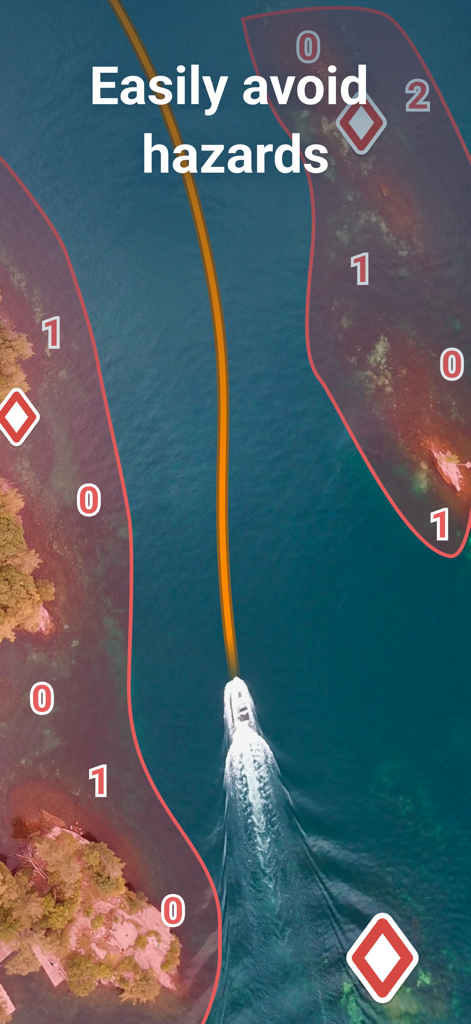
Wavve Boating 해양 GPS 앱에서 빨간색 위험 구역 사이의 안전한 파란색 경로를 통과하는 보트
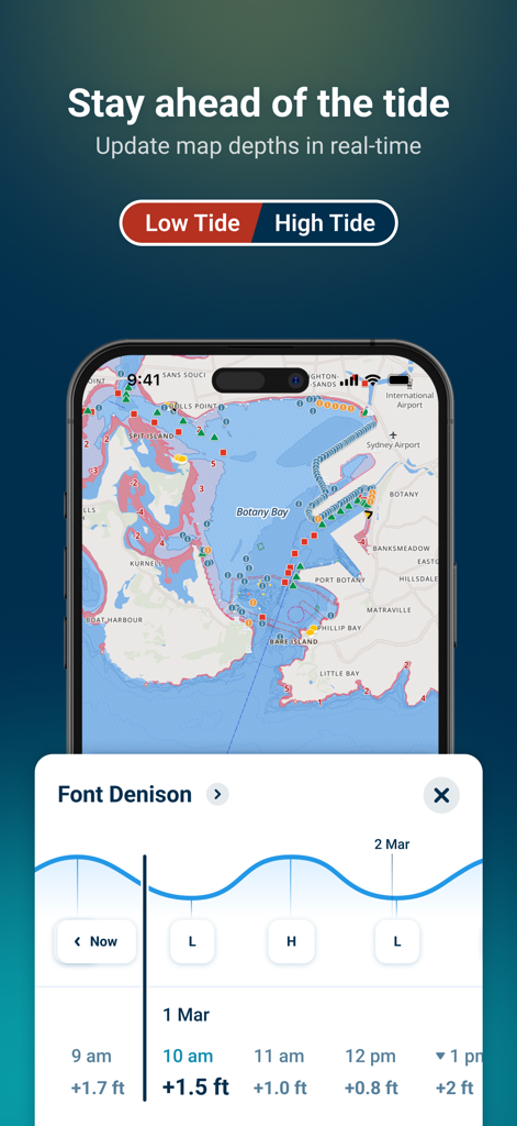
Wavve Boating 앱이 해양 GPS 차트에 실시간 조수 예측 및 수심 업데이트를 표시하고 있음
바람 속도와 파도 높이를 포함한 해양 날씨 예보를 표시하는 Wavve Boating 앱의 모바일 인터페이스
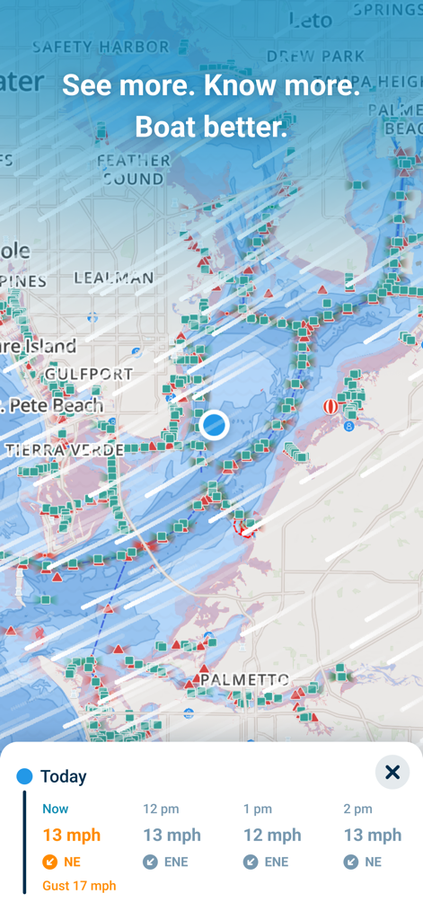
실시간 바람 속도 및 날씨 예보 패널이 있는 해상 항해 지도를 표시하는 Wavve Boating 앱 인터페이스
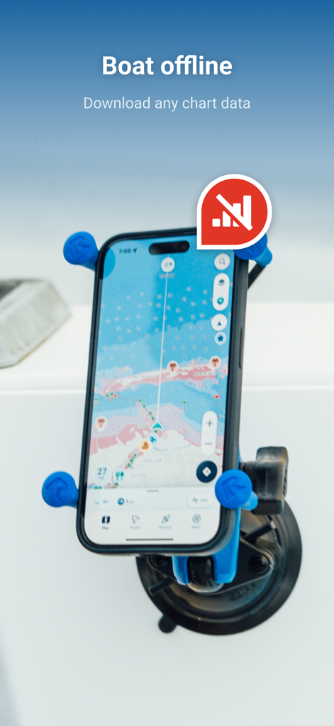
오프라인 해도 기능을 갖춘 Wavve Boating 앱을 표시하며 보트에 장착된 iPhone
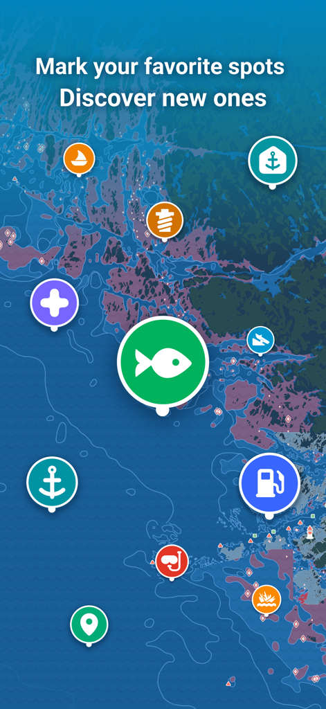
낚시, 연료, 정박지 등을 나타내는 다채로운 아이콘이 있는 해도
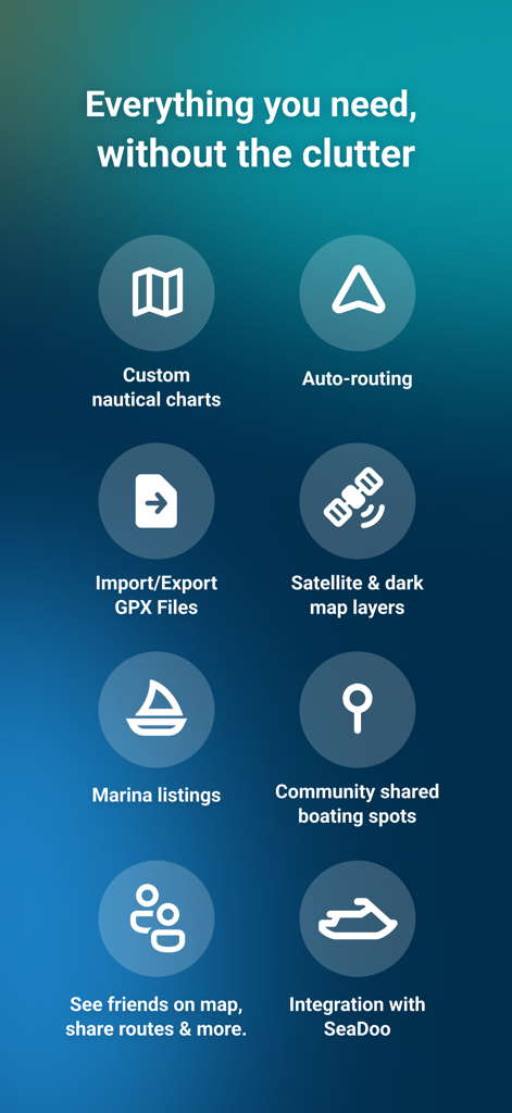
맞춤형 해도, 자동 경로 설정, 소셜 네비게이션 도구 등 Wavve Boating 앱 기능 목록
설명
Download
비슷한 앱
유사한 기능과 사용자 경험을 가진 앱

PredictWind — Marine Forecasts
PredictWind Limited

Navily
The Navigation Family

Argo - Boating Navigation
Argo Navigation, LLC

SEAiq Pilot
Sakhalin, LLC

Maptrails
Pasi Salenius

KartenWerft NavGo 2.0
KartenWerft GmbH

MarineTraffic - Ship Tracking
MARINETRAFFIC APPLICATIONS LTD

Savvy Navvy Boating Navigation
SAVVY NAVVY LTD

Aqua Map Boating
GEC s.r.l.
이 페이지는 앱이나 개발자의 공식 페이지가 아니며, 정보 제공 및 논평을 목적으로 작성된 독립 편집 간행물입니다. 명시적으로 달리 언급되지 않는 한, 해당 앱이나 개발자는 MWM, Apple, Google Play, 앱 퍼블리셔 또는 앱 개발자와 제휴, 보증, 후원, 승인 또는 공식적으로 연결되어 있지 않으며, 이 페이지의 어떤 내용도 해당 앱이 MWM의 서비스를 사용하여 개발되었음을 의미하지 않습니다. 모든 상표, 로고, 스크린샷 및 기타 콘텐츠는 해당 소유자의 자산입니다.