이 페이지는 앱이나 개발자의 공식 페이지가 아니며, 정보 제공 및 논평을 목적으로 작성된 독립 편집 간행물입니다. 명시적으로 달리 언급되지 않는 한, 해당 앱이나 개발자는 MWM, Apple, Google Play, 앱 퍼블리셔 또는 앱 개발자와 제휴, 보증, 후원, 승인 또는 공식적으로 연결되어 있지 않으며, 이 페이지의 어떤 내용도 해당 앱이 MWM의 서비스를 사용하여 개발되었음을 의미하지 않습니다. 모든 상표, 로고, 스크린샷 및 기타 콘텐츠는 해당 소유자의 자산입니다.

Merge GPX
다일 녹음과 GPS 간격을 손쉽게 연결합니다. 지구력 운동선수가 전체 모험 이야기를 시각화하면서 심박수 및 고도 데이터를 보존하는 강력한 오프라인 도구입니다.
다운로드
3K+사용자 평점
총 평가 수
0개발사
카테고리
Navigation지원 언어
1최신 버전
1.0.9크기
1.5 MB출시일
2025년 6월 17일지도를 마스터하세요
다음 장대한 모험을 위해 다중 세그먼트 GPX 파일을 단일 고품질 루트로 통합하는 가장 빠른 방법입니다.
깨진 녹음 수정
GPS가 실패하거나 배터리가 방전될 때 간격을 연결합니다. 스마트 경로 지정으로 세그먼트를 하나의 연속적인 선으로 다시 연결합니다.
프로급 데이터 보존
성능 지표를 그대로 유지합니다. 정확한 훈련 분석을 위해 모든 심박수, 파워 및 케이던스 데이터를 보존합니다.
다음 스크린샷과 설명은 앱의 공식 스토어 목록에서 직접 가져온 것이며 앱 개발자의 자산입니다.
앱 스토어
스크린샷
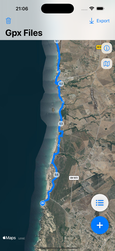
Merge GPX 앱에서 해안선을 따라 병합된 GPS 경로를 보여주는 위성 지도 보기
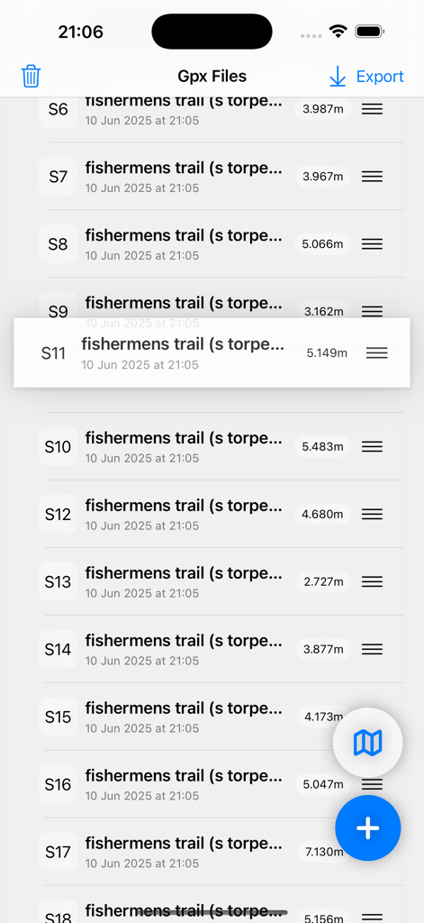
Merge GPX 앱 인터페이스 내에서 수동으로 재정렬되는 GPX 트레일 세그먼트 목록
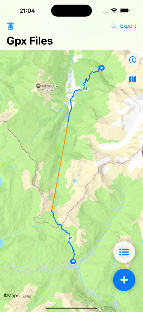
Merge GPX 앱의 지형 지도에 S1과 S2로 표시된 두 개의 파란색 GPS 트랙 세그먼트가 주황색 선으로 연결되어 있음
설명
Download
비슷한 앱
같은 카테고리의 상위 앱

Google Maps
Google LLC

Waze Navigation & Live Traffic
waze

AMap Global
AutoNavi Information Technology Co. Ltd.

百度地图-路线规划,出行必备
Beijing Baidu Netcom Science & Technology Co.,Ltd

Moovit: Bus & Transit Tracker
Moovit App Global LTD

Transit • Subway & Bus Times
9280-0366 Quebec inc.

ParkMobile: Park. Pay. Go.
Parkmobile USA, Inc

腾讯地图-路线规划,导航地铁打车出行
Shenzhen Tencent Computer Systems Company Limited

Île-de-France Mobilités
Ile de France Mobilites
이 페이지는 앱이나 개발자의 공식 페이지가 아니며, 정보 제공 및 논평을 목적으로 작성된 독립 편집 간행물입니다. 명시적으로 달리 언급되지 않는 한, 해당 앱이나 개발자는 MWM, Apple, Google Play, 앱 퍼블리셔 또는 앱 개발자와 제휴, 보증, 후원, 승인 또는 공식적으로 연결되어 있지 않으며, 이 페이지의 어떤 내용도 해당 앱이 MWM의 서비스를 사용하여 개발되었음을 의미하지 않습니다. 모든 상표, 로고, 스크린샷 및 기타 콘텐츠는 해당 소유자의 자산입니다.