이 페이지는 앱이나 개발자의 공식 페이지가 아니며, 정보 제공 및 논평을 목적으로 작성된 독립 편집 간행물입니다. 명시적으로 달리 언급되지 않는 한, 해당 앱이나 개발자는 MWM, Apple, Google Play, 앱 퍼블리셔 또는 앱 개발자와 제휴, 보증, 후원, 승인 또는 공식적으로 연결되어 있지 않으며, 이 페이지의 어떤 내용도 해당 앱이 MWM의 서비스를 사용하여 개발되었음을 의미하지 않습니다. 모든 상표, 로고, 스크린샷 및 기타 콘텐츠는 해당 소유자의 자산입니다.

ok2fly
심각한 취미 조종가 및 ReOC 소지자 모두를 위해 설계된 실시간 CASA 안전 규칙, 4D NOTAM, 정밀 시간 계획으로 호주 영공을 마스터하세요.
다운로드
43K+사용자 평점
총 평가 수
0개발사
카테고리
Navigation지원 언어
1최신 버전
1.6.0크기
75.6 MB출시일
2022년 1월 12일완벽한 자신감으로 임무를 계획하세요
전문가 및 레크리에이션 드론 조종사를 위한 최고의 안전 도구로, CASA 규정 준수 데이터와 고정밀 4D 상황 인식 기능을 결합하여 장비와 면허를 보호합니다.
공식 CASA 통합 규정 준수
CASA RPAS 플랫폼과 완벽하게 통합된 도구를 사용하여 완전한 마음의 평화로 비행하세요. 현재 안전 규칙을 준수하고 공식 Airservices Australia 허가 시험에 직접 액세스하세요.
초지역별 상황 인식
'녹색 신호' 이상의 것을 얻으세요. 4D 제한 영공, 공항 권역, 실시간 NOTAM을 학교, 교도소, 공원과 같은 지역 랜드마크와 함께 시각화하여 법적 분쟁을 피하세요.
자주 묻는 질문
에 대해 알아야 할 모든 것 ok2fly
ok2fly는 무엇인가요?
ok2fly는 조종사가 임무를 계획하고, 영공을 시각화하고, 규정을 준수하도록 돕는 드론 안전 도구입니다. 상세한 지도와 실시간 운영 환경 분석을 제공합니다.
ok2fly는 드론 비행 금지 구역을 표시하나요?
예, ok2fly는 활주로 유출, 공항 구역에 대한 상세한 시각화를 제공하며, 제한 및 위험 구역을 자동으로 시각화합니다. 활성 관제탑을 기반으로 비행 금지 구역을 식별합니다.
ok2fly는 비행 계획에 어떻게 도움이 되나요?
ok2fly는 구성 가능한 반경으로 즉각적인 드론 비행 영역을 조사하고, 상세한 위치 보고서를 제공하며, 예정된 비행 시간에 맞춰 지도 정보를 조정합니다.
ok2fly는 호주 CASA 규정을 준수하나요?
예, ok2fly는 CASA RPAS 안전 규칙을 완전히 준수하며 CASA RPAS 플랫폼과 통합됩니다. CASA / Airservices Australia 영공 승인 시험에 참여했습니다.
ok2fly는 상세한 비행 보고서를 제공할 수 있나요?
예, ok2fly는 위치 주변의 영공을 분석하고 상세한 위치 보고서를 제공합니다. 이 보고서에는 운영 영공에서 감지된 모든 알려진 랜드마크가 포함됩니다.
ok2fly는 드론을 비행할 수 있는지 여부를 알려주나요?
예, ok2fly는 예정된 비행 구역 및 선택한 조종사 자격에 대한 분석을 기반으로 "비행 가능", "비행 불가" 또는 "조건부 비행 가능"과 같은 명확한 표시를 제공합니다.
ok2fly는 호주의 어떤 지도 데이터를 제공하나요?
ok2fly는 호주 전체의 거리 수준 벡터 지도를 제공합니다. 일반적인 거리 정보, 장애물, 저고도 항공 활동 및 레크리에이션 장소와 같은 항공 정보를 자세히 설명합니다.
ok2fly에서 지도에 오버레이를 추가할 수 있나요?
예, ok2fly는 항공 교통, 날씨, 번개와 같은 동적 옵션을 포함하여 추가 지도 오버레이를 지원합니다. FIA 주파수 경계 및 통제 영공과 같은 정적 오버레이도 사용할 수 있습니다.
ok2fly는 드론 운영에 대한 실시간 NOTAM을 표시하나요?
예, ok2fly는 드론 운영에 영향을 미치는 NOTAM 활동을 자동으로 시각화합니다. 유료 구독 시 제한 및 위험 영공에 대한 지속적으로 업데이트되는 NAIPS NOTAM 정보도 제공합니다.
내 특정 드론 조종사 자격에 맞게 ok2fly를 구성할 수 있나요?
예, ok2fly는 Micro, Recreational, Commercial Excluded 및 ReOC의 네 가지 CASA 조종사 유형을 지원합니다. 사용자는 설정을 통해 자격에 맞는 조종사 유형을 설정할 수 있습니다.
ok2fly의 모든 기능에 유료 구독이 필요한가요?
아니요, ok2fly의 일부 고급 기능에는 유료 구독이 필요합니다. 여기에는 Commercial Excluded 및 ReOC 조종사 유형, Layers 옵션, NAIPS NOTAM 검사 및 무선 주파수 데이터가 포함됩니다.
ok2fly 유료 구독에는 무엇이 포함되나요?
유료 ok2fly 구독에는 Commercial Excluded/ReOC 조종사 유형, 고급 지도 레이어, NAIPS NOTAM 검사, 무선 주파수 데이터 및 AvPlan-EFB Standard Plus 액세스와 같은 기능에 대한 액세스가 포함됩니다.
ok2fly는 다른 디스플레이 모드를 제공하나요?
예, ok2fly는 사용자 선호에 따라 밝은 모드와 어두운 모드를 모두 제공합니다. 사용자는 다양한 조명 조건에서 가시성을 최적화하기 위해 이 모드 간에 전환할 수 있습니다.
ok2fly 제공업체인 AvSoft Australia는 인증된 데이터 제공업체인가요?
예, ok2fly 개발사인 AvSoft Australia는 CASA Part 175 승인 데이터 제공업체입니다. 이는 앱의 데이터가 공식적이며 항공 표준을 준수함을 보장합니다.
다음 스크린샷과 설명은 앱의 공식 스토어 목록에서 직접 가져온 것이며 앱 개발자의 자산입니다.
앱 스토어
스크린샷
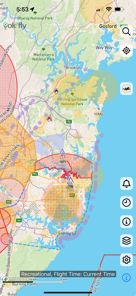
ok2fly 앱에서 제한된 비행 구역과 안전 정보를 보여주는 상세한 드론 영공 지도
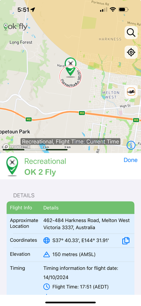
지도와 레크리에이션 드론 비행 계획 세부 정보를 보여주는 ok2fly 앱의 스크린샷
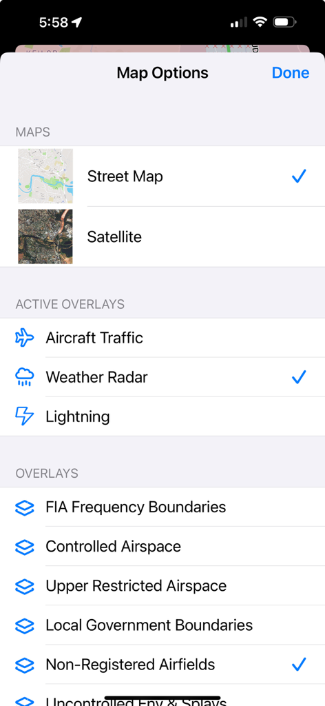
날씨 레이더 및 통제 영공과 같은 항공 오버레이 및 거리 지도 위성 보기 옵션을 보여주는 ok2fly 앱의 지도 설정 화면
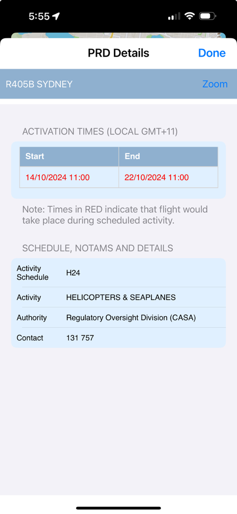
ok2fly 앱이 활성화 시간 및 헬리콥터 활동 일정을 포함한 시드니 PRD 세부 정보를 표시함
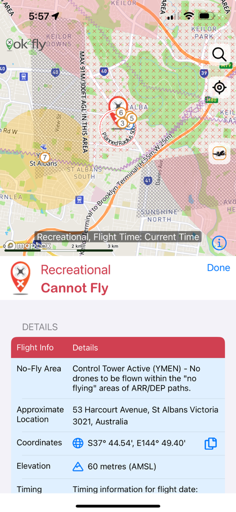
호주 관제탑이 활성화되어 드론 비행 금지 구역이 표시된 ok2fly 앱 스크린샷
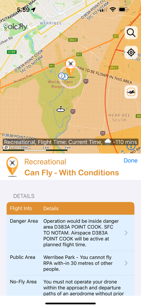
레크리에이션 조종사를 위한 드론 비행 안전 조건 및 지도를 보여주는 ok2fly 앱 스크린샷
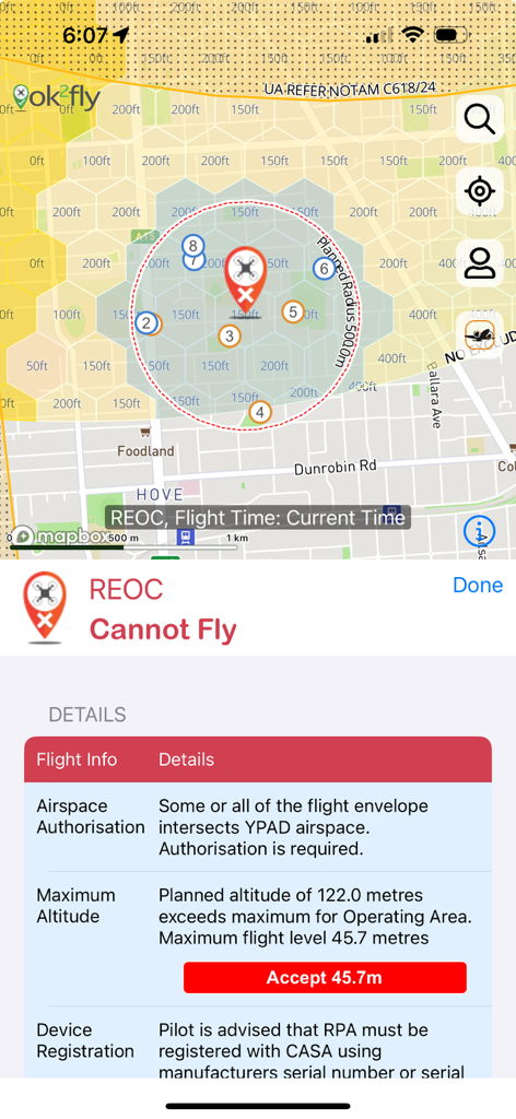
REOC 조종사를 위한 제한된 드론 비행 구역 지도와 상세한 안전 경고를 표시하는 ok2fly 앱 스크린샷
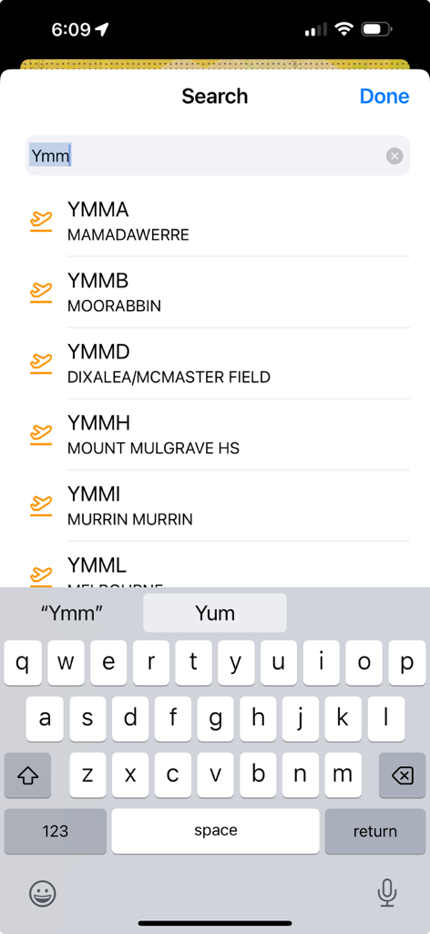
ok2fly 앱 검색 화면에 호주 공항 코드 및 이름 목록이 표시됨
설명
Download
비슷한 앱
같은 카테고리의 상위 앱

Google Maps
Google LLC

Waze Navigation & Live Traffic
waze

AMap Global
AutoNavi Information Technology Co. Ltd.

百度地图-路线规划,出行必备
Beijing Baidu Netcom Science & Technology Co.,Ltd

Moovit: Bus & Transit Tracker
Moovit App Global LTD

Transit • Subway & Bus Times
9280-0366 Quebec inc.

ParkMobile: Park. Pay. Go.
Parkmobile USA, Inc

腾讯地图-路线规划,导航地铁打车出行
Shenzhen Tencent Computer Systems Company Limited

Île-de-France Mobilités
Ile de France Mobilites
이 페이지는 앱이나 개발자의 공식 페이지가 아니며, 정보 제공 및 논평을 목적으로 작성된 독립 편집 간행물입니다. 명시적으로 달리 언급되지 않는 한, 해당 앱이나 개발자는 MWM, Apple, Google Play, 앱 퍼블리셔 또는 앱 개발자와 제휴, 보증, 후원, 승인 또는 공식적으로 연결되어 있지 않으며, 이 페이지의 어떤 내용도 해당 앱이 MWM의 서비스를 사용하여 개발되었음을 의미하지 않습니다. 모든 상표, 로고, 스크린샷 및 기타 콘텐츠는 해당 소유자의 자산입니다.